


Live Your Best Lives
Appalachian Trail Reviews
4.8
544 of 4,484 Best Attractions in Georgia


Reviews

Great Day Hike
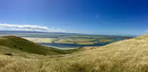
We hiked the Springer Mountain Loop trail at the beginning of the the AT. We had a fantastic time. If you head out away from Springer Mountain at the trail head you have gentle uphill climbs to a viewing area just before Ball Mountain. When you get to Springer Mt you can see the marker for the beginning of the AT.

A bucket list adventure
I visited this attraction on 1 June 2016 with my two boys (13 and 10 yrs. old).
To access it by car you have to drive up a 10.4-mile dirt/gravel road to the Chattahoochee National Forest parking lot (fwiw, Google Maps guided me there just fine). This parking lot is free and you may park there for up to 14 days (presumably that would give you enough time to hike the Appalachian Trail 160 miles roundtrip to North Carolina and back). It is also one mile north of the southern terminus of the Appalachian Trail. The terminus is marked by a plaque in the stone. If you venture past the terminus, you will enter the "Appalachian Approach Trail" to Amicalola Falls which is 7.8 miles away. If you park and walk to the terminus but want to hike the Appalachian Trail 2,190 miles north to Maine, then you will have to backtrack past where you parked. The boys and I hiked about 6 miles in 3 hours (the path was up, down, and sinusoidal over many rocky portions).
Pros: lovely, dense green scenery; it's cooler in the mountains compared to sea level; nice bonding experience with family and nature
Cons: It took me almost an hour to reach the parking lot by car along some treacherous blind spots with a half-dozen vehicles (including some U.S. Army HMMWVs) going the opposite direction forcing me to the edge. Portions of the trail from the parking lot to the southern terminus are very rocky so watch your step and wear good hiking boots to protect your ankles.
Other: Recommend venturing forth wearing comfortable hiking boots and a backpack (keep your hands free for balancing) that includes water, snacks (e.g., trail mix, power bars), bug spray (lots of mosquitos are around), a parka (it could rain at any time), a compass, and a map of the area that includes landmarks such as shelters.

Blonde Bambi's on the AT
My girlfriend and I recently hiked the majority of the georgia AT. October was a great time of year for visual aesthetics as well as listening to the leaves crunching under our feet. No bear or water issues to speak of but we did hear a lot of gunshots as we were hiking during Hunting season. Fortunately we came prepared and wore orange caps to avoid our blonde hair resembling "2 deer tails" wandering thru the forest :-)..

Fun and conditioning
The AT starts at Springer but I also love the approach trail from Amicalola where the lodge is worth a trip in itself.

Great trail anywhere along the route
Springer Mountain, which is the southern terminus for the Appalachian Trail is really a beautiful place to visit for a quick trip on the AT. It starts with a moderate 1.1 mile climb from the Spring Mountain parking lot and ends at the AT trail head. You have a beautiful view of some mountains and is a favorite spot to watch the sunset. Just be sure to bring your tent to stay over or a flashlight to get back. If you are really up for a hike, you can park at Amicalola Falls State Park and take the 8 mile trail to this spot.

Beautiful and challenging trail
Took a trip to the Len Foote Hike Inn. You need to be trained on walking. Trail is purely natural, which means uncountable stones and tree roots. A walking stick is absolutely helpful, trail boots as well. The Len Foot Hike Inn with its rockin chairs provides a million dollar view. Overnight stays include homemade dinner and breakfast.

Getting a Taste of it
After hiking the AT across Maryland and down along the VA/WVA border area, I came to Georgia to get a taste of how the trail starts out. It was a great experience. I loved meeting a number of through-hikers and loved the freedom of being able to camp quite easily (which is not always so up north). Definitely a work-out as you hike up and down the mountains.

Great day hike near Dahlonega
Park at the Springer Mountain Trail parking lot (via gravel forest service road) and walk the Springer Mountain Loop. Great Views ! Not as crowded as the AT.

2179 Miles Trail
Appalachian Trail, a route in the eastern United States that runs from Maine to Georgia.The trail was originally conceived by forester Benton MacKaye who envisioned a grand trail that would connect a series of farms and wilderness work/study camps for city-dwellers.We did not venture in to the trail walking as it was getting late for us

Best Trip!
I went with an organization to have a guide! I had the most incredible trip! There were 7 of us who hike a 17 miles portion of the AT! We camped and carried all our gear (40 pounds). It took a lot of training, but we went during late September (which is perfect!). No snake sightings, yay! An incredible week!

I done all 70 something miles on the Georgia trail. I would do it again and pack light.

Bucket list item
As we planned our vacation in Blue Ridge, Ga., I wanted to make sure we visited the Southern Terminus of the AT at Springer Mountain. Not only did we accomplish that, we also made the hike from the Byron Reece Trailhead up to the summit of Blood Mountain a couple of days later. Granted, we only hiked about 2.5 miles of the AT in any one direction, the parts we were able to do gave us a great introduction and appreciation for the trail itself, and certainly for those who have hiked the full 2,200-mile length during their lifetimes. I can only imagine what that might be like. Hope to return one day and during a different season to hike MUCH more of this great trail!

Fun day in Ga
We drove 1 hr from north of Atlanta to Neels Gap (north of Dahlonega) on hwy 19. Parking is 1/4 mile up from the hiker's store. The store on the right side of the road has supplies, restrooms and only 20 mins parking. You can drop people off here and find longer term parking on the left side of the road. All of the parking was free; however it can fill up, so you might want to solve the parking issue before lingering at the store if you plan to hike to Top of Blood Mountain. Both store and parking lot trails intersect for continuing to the top. If you leave from the parking lot; you will follow the blue trail markings and then turn right and take the white trail markings (AP). 7/10 of mile. This intersection was not labeled to " Blood Mountain.". It took us 3 hrs round trip. Nice shady path, steep climb for 1st and last portion. Just keep following the white markings. Best in good hiking shoes; but I saw tennis shoes in use. I use a walking stick; my husband does not.
It is very interesting in seeing the thru hiker's; and weekend hiker's. Everyone was friendly
and for a Saturday not as crowded as I would have expected. Be sure to bring water and it is great to have a snack or lunch at the top. It is a beautiful vista all around at the top. There are several nice rocks to have your lunch. There is a stone shelter at the top and also a privy at the top; but no water, so be sure to bring enough for your entire hike. There are open areas for views and also shady areas at the top.
After our hike, we stopped in Dahlonega and listened to the locals jamming every Sat 2-5 at the town square and then had a great dinner at the award winning Smokin' Gold BBQ 59 East Main Street just off the town square. A fun day; especially if one wants to get out and hike.

Clingmans Dome
This section of the Appalachian trail is just gorgeous, is part of the great Smokey mountains national park, an elevation of 6,643 feet, it is the highest mountain in the Smokies, the highest point in the state of Tennessee, and the highest point along the 2,174-mile Appalachian Trail.

Neels Gap
This was my first AT experience. Neels Gap delivered in an amazing way! There was an easy place location to park with no cost involved. There was a store called Moutains Crossing that was AMAZING! They had tons of really cool gear and supplies that were really helpful. The staff was answered all of my questions are really helped me plan my course. Definitely stop by before heading out.
This was my first trip and I was solo and choose to hike away from Blood Mountian. One because it was bear season and I was solo, but two, Blood Mountain had a ton more people. Neels Gap was my perfect solitary escape. I couldn't have asked for anything more from a first trip.

Gorgeous in April!
Hiking part of the Georgia section of the Appalachian Trail was very tough but well worth it! The shelters and water sources were great and the scenery was beautiful. The through hikers were still beginning so we decided to do our section hike heading south. There were some amazing people and great stories!

The view is amazing
While we have taken this climb to Blood Mountain in the past, this was the first time we took the five mile roundtrip in the snow. Started today at the store at mountain crossing and took the trail up to Blood mountain. The weather this morning was extremely cold and the wind was blowing 20+ miles per hour. It was snowing, while not hard, enough to cover the ground.
We almost decided to give up, but once we were about half way the wind died down and snow let up. The views from the top of Blood mountain are amazing and this is the first time we were able to do the climb and see snow all around.
Remember to take at least 2 bottles of water and take your time. I would allow around 3-4 hours for the round trip if you don't stop alot.

Challenging Trail That Provides Spectacular Views
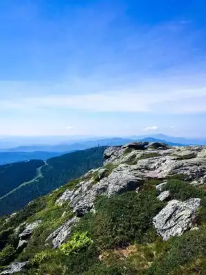
My brother & I recently hiked the Appalachian National Scenic Trail from Mountain Crossing at Neel’s Gap to the summit of Blood Mountain. The natural terrain trail gains elevation while winding through the forest. As you near the tallest peak on Georgia’s stretch of the Appalachian trail on a clear day the views are spectacular. At the summit you will also find a rock shelter. On a clear weekend day you will have lots of company as this trail is one of the most popular hiking destinations in Georgia. We had a fantastic hike and will definitely return. Parking is limited to 24 paved spaces & 14 gravel spaces at the Bryon Herbert Reece trail head. FYI… No on site water or restrooms.

Wonderful scenic drive
We took this drive on April, and it's amazingly beautiful. We could only wonder how much more beautiful it should be in autumn. We went from Dahlonega to Blue Ridge and it's quite a ride. A lot of curves so if you tend to get dizzy, I strongly suggest you take a dramamine

A must do!
I hiked the first leg of the AT with my son. We began at Springer Mountain and I got off the trail at Plumorchard Gap near the NC border. Most intense thing I've ever done. Didn't know I could hurt like that. Hiked two weeks. Would do it again in a heart beat.

treked up to springer mountain
we went for a nice .9 mile hike to the summit of springer mountain in GA to see the start of the Appalachian trail...it was kinda steep and rocky but well worth the view, etc

Blood Mountain, Woody gap to Neels gap
I took a short one night solo backpacking trip over Blood Mountain. I left my car at Neels Gap and got a shuttle from thestore over to woodys gap ($40). The hike has a lot of nice views and rolling hills. I stayed the night in wood holes shelter. It had a privy so that was a bonus! finished the next day over Blood, only took me a couple hours to hike out. A nice hike, moderately strenuous, tallest point on the Ga section of the AT. The views made the entire trip worth it. Only been better if i had come earlier in the season to see the leaves change.

Metro North - Only Train Stop On The Appalachian Trail
This is a trip we have decided will become a regular getaway from NYC during the summer. Two adults and one child can get a roundtrip from Harlem-125th Street to, yes, The Appalachian Trail stop for only $63. No car rental hassle, just put on your backpacks, get to the train and, after one transfer, you exit off of the back of the last car on the train and head off into the hills, either east or west (that's north to Maine or south to Georgia).
We took our 6-year-old son up two Sunday's ago and just did an overnight at the Telephone Pioneers Shelter. We brought a tent, just in case, but only ran into one other person at the shelter. Another couple arrived a little later and pitched their tent down the hill, even though there was plenty of space for more people in the shelter. Nice to have options!
Our son is a particularly active kid, and he packed in his sleeping bag, sleeping mat and essential clothes and toys on his back. However, it's a very doable hike, pretty mellow. Even if you take the 10 o'clock train and arrive near noon, you'll still be able to get to the shelter with plenty of time left for exploring and making dinner, especially in late spring and early summer when the days are longer. (There's a pit toilet at the site, so be prepared for semi-primitive living).
We are thinking about going again this weekend, though the forecast has a chance of rain. That's what plastic bags are for, though, right?
If you like to camp and you're tired of car camping, this is the ticket!

Physically demanding, but beautiful
Hiked 20 miles on the AT in three days. It was the most physically demanding thing that I have ever done. The scenery was beautiful and it was an experience that I will never forget. If you are thinking about hiking it please take the right equipment and do your research. You want to enjoy your hike not be wishing that you never started.

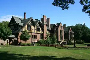
The Civilian Conservation Corps made its mark here
The staff at Vogel State Park, outside of Blairsville, GA, picked up on my interest in the history of the Civilian Conservation Corps, who were largely responsible for developing Vogel State Park in the 1930s. So they recommended we drive down Rt 129 to a surviving CCC building called Walasi-Yi. The building was almost torn down many years ago, but is now thriving as a stop for serious Appalachian Trail hikers.
The Mountain Crossing outfitters store is incredibly well stocked for those rugged hikers. Our interest was in the historic building, the rafters, the stone work, and the "Neels Gap" point of interest- the only point where the Appalachian Trail goes through a man-made structure. The views at Walasi-Yi are breath-taking.
I might not take up serious hiking, but Walasi-Yi was a very interesting stop for us, as we "played tourist" in this area of Georgia.

Great for day hikes, too!
Casual hikers and families will enjoy the Georgia segments of the trail, as there is easy access and beautiful scenery. Some of the trails can be steep, though. There is a great trailhead between Helen and Hiawassee (on 75, about halfway between the two towns) with excellent hiking on both sides of the road/parking lot.
Popular Attraction Reviews


Tough but extremely rewarding trail
I did this trail from the Bryon Reece trail. The trail head is just up Hwy 19 between Cleveland and Blairsville. From my memory the trail is about 2.5 miles one way. It starts off near a stream and about mile .75 it stars climbing steeply with a number of switchbacks. It connects with the AT around 1 mile or so. The AT section is steep but has switchbacks. It was an amazing trail to do in early Winter. I did this in December. Towards the summit there are rock out-croppings that are shown in the photos that provide some great views. There's lots of hikers to chat w/ at the summit and overall just a really rewarding hike. I rate this easily as one of the top 5 in Georgia. It is rated as stenous but if you are in decent shape, drink plenty of water/drinks, and take it slow I think anyone in decent shape will be able to complete this trail. This is a must for any outdoor enthusiast in Georgia and a great taste of one of the best sections of the AT w/o having to do the entire AT :)