


Live Your Best Lives
Fiery Gizzard Trail Reviews
4.7
557 of 3,770 Best Attractions in Tennessee


Reviews

Hardest trail I have ever done
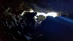
Went on July 10; started at 8:30 and finished at 4:15. We left a car at foster falls and took other car back to the other end. Nice parking at both ends, bathrooms at both ends. We went in to the day loop to the left and went into the gizzard. We took the dog hole trail. If dog hole is the easiest one I would hate to go thru on the gizzard trail down in the gorge. Here is what to expect: There is no way of knowing where you are at hardly any point on the trail. You know where the dog hole leaves because there is a sign. Then you find a sign that says you are 4.2 I think it said in and 8.2 or so to foster falls. Then you know where you are at again at the small wilds campground. There are 2 places on the trail that are extreme up and down. One has a lot of rock steps up and down but is very difficult and steep. The other bad part is before you climb out near the small wilds campsite. No steps here just down the mountain and cross a foot bridge and right back up the side of the mountain. You have to hold onto tree limbs and rocks to get down and up.
Pros: beautiful, secluded (seen no other hikers either way), challenging, well marked with plenty white blazes, pretty clean trail maybe 5 blow downs total across trail
Cons: you don’t know you location hardly at all, scarce water sources (again we took dog hole)
My advice: be sure you can do this before you try it, carry plenty of fluids, keep pack weight down as low as you can, clothes should be breathable and dry fit , no cotton

Heavenly
Even if you don't have time to hike very far, this is worth a visit. The trail starts to descend almost immediately from the parking lot, and you are next to the stream within 10 minutes. Trail is in very good shape, parts of it are steep (I'm 58 and in moderately good shape, but I needed hiking poles to feel safe and comfortable.) Beautiful old-growth trees, ferns, peace and quiet. On a Monday morning, there were just enough people around that I felt OK hiking by myself.

Pleasant Hiking Experience at Fiery Gizzard North Trailhead
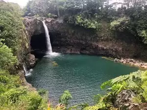
This was a very pleasant hike. My husband and I hiked the Grundy Forest Day Loop Trail which was about a 2 mile loop. I would classify the trail as moderately difficult. I was happy to see families with very young children as well as older people enjoying the trails. Make sure to wear sturdy shoes and thick socks for optimal foot protection since there are many rocks and tree roots to step over. Be sure to take plenty of water and maybe even a swimming suit to cool down in the various natural pools of the creek.

Hiking the Fiery Gizzard - A Wonderful Hike!
We hiked the Fiery Gizzard trail yesterday (a group of 4 girls in our 30s). We stopped at the South Cumberland State Park Welcome Center and talked with Cina before our hike. She was wonderful! I highly recommend that you stop and see her there before your hike. While you’re here, you can grab maps and ask questions about the trail. We heard that a lot of people do a 2 mile loop at Grundy Forest, or they hike the trek from Grundy Forest to Raven’s Point Overlook and back (which would be about 4/4.5 miles each way). We opted for the point to point hike from Grundy Forest to Foster Falls (13 miles; around 14 with the .5 mile hike each way to view the Raven’s Point Overlook).
Once we left the Welcome Center, we headed out to hike the Fiery Gizzard. The trail was great! We started at the Grundy Forest parking area and went past Blue Hole Falls. Then we took the Dog Hole Trail and bypassed the Fiery Gizzard, bottom of the gorge portion which is very rocky and strenuous (or so we heard). I’m very glad we took that recommendation!
Then we hiked out to Raven’s Point Overlook, and we saw spectacular views and had lunch at the overlook. We then hiked the Fiery Gizzard Trail to Foster Falls parking area and bypassed the Climber’s Loop. (From the intersection of Raven’s Point Campground, you have 8 miles to Foster Falls.)
During the last 2 or 3 miles, there was some pretty strenuous climbing through rocks and boulders. After that, you have to climb up a gorge back to the top of the mountain (pretty much straight up rocks and boulders). It was tough, but totally doable! We hiked an estimated 14.6 miles (with the trip to Raven’s Point Overlook and additional stops and detours) and it took us from around 10am to about 6pm (8 hours). We stopped a lot to take in the scenery and rest, but we made pretty good time as large portions of the trail were relatively flat. This was a beautiful trail, and we had a great time! It definitely tested our limits, but we loved every second. If you’re in pretty good shape, this will be no problem.

How To Hike Fiery Gizzard And Live To Tell The Tale
We just hiked this trail with friends while staying at the CCC campground. We went up to Raven Point, which ended up making our entire day an 11 mile round trip hike that is not for the faint of heart. The scenery was absolutely gorgeous, especially since we hit the trail in the fall with lots of autumn color. This is what all of us came up with as far as recommendations for the average person when hiking this trail:
Hiking boots - Please don't wear sneakers to hike this trail. Hiking boots are ugly, let's be honest. I looked all over the freaking city to find a pair that were both comfortable and not as ugly, but I'm beyond thankful that I had them. I bought the J-41 Srina, made by Jeep. They had fantastic tread so I could handle the rocks easily, but they also offered some ankle support, which is crucial on this trail.
Duct tape and superglue - These are listed in lieu of bringing an extra pair of hiking boots. We dubbed this trail the "Sole Taker" because the possibility of you actually losing your sole on this trip is pretty high. Due to the ankle bending, rock strewn, boulder laden trails, you need some serious shoes to tackle the Gizzard. We passed one woman halfway in who had lost the soles off both of her shoes. Later on in the day, the same thing happened to Jessie with her Asolo hiking boots that had only been worn a few times. After we finished the trail, a ranger told us that was actually quite common. Be prepared, people!!!
Moleskin - If you are prone to blisters, or are wearing hiking boots you don't wear too often or haven't fully broken in, this is a must.
Walking stick or pole - This is purely based on personal preference. I think I would have had balance issues and felt encumbered by a walking stick, but for one person in our group, they were lifesavers and helped her navigate some of the rockiest portions of the trail.
High protein food for energy - We brought cut peppers, hummus, and high protein granola bars with us. These got us through the day and we didn't feel like we were starving. They gave us the energy we needed to keep going. Others in the group had jerky, salami, cheese, etc. Basically, bring food that is fuel. Every time we stopped to eat, we felt like we had renewed energy.
Water - Obviously, this is a must. If you don't want to bring 4 bottles of heavy water, bring a camping water filter. There is a gorgeous river that runs along the Fiery Gizzard trail which could be a good water supply with the proper filtration equipment. Otherwise, pack plenty of water, it is essential.
Camera - I have a small Canon Powershot Elph that I love bringing on trips like this. Phone cameras are great, but batteries should be conserved in case of emergency.
PStyle - For women who camp, this is a must!!! This little plastic contraption enables you to pee while standing. I was beyond thankful that I'd spent the money and brought this silly thing along. It was totally worth having and made what could have been an awkward situation pretty easy. Otherwise you could "monkey pole" where you hold onto a sapling, lean back and hope you don't pee all over yourself.
Moisture wicking everything - Before we left on this trip I splurged and bought a North Face base layer at TJ Maxx that was moisture wicking. Even though there were parts of the day when I was really sweating, my shirt never felt soaked and I stayed quite comfortable. I also wore wool socks, Smartwool is best (I've also seen these at TJ Maxx), and my feet weren't swampy or damp. If we were doing this in summer, I'd buy moisture wicking t-shirts or tank tops. The right clothing makes a world of difference in comfort level when you're sweating your way up a trail.
Backpack - If you're planning to do the entire loop in a day and not camping up at Raven's Point, a regular old backpack works. Make sure there are plenty of pockets and straps to carry what you need. If you can find one that has chest and waist straps, that might help eliminate some of the weight on the shoulders.
Ace bandage - Although it's never nice to think of being hurt on a trail, this is one of those things that is lightweight and easy to throw in a bag. If you end up needing it, you will thank your lucky stars that you have it. This trail is brutal on the knees, ankles, and hips. On the way down, there is one hill that is a knee jerker for sure and there are countless sections of the trail where you walk on nothing but rocks. Bring first aid in case something unplanned happens.

KING GIZZARD AND FIERY GIZZARD
the Australian band King Gizzard and The Lizard were here, I was there 2 hours before, UGH oh and they were in TN for the cancelled Bonnaroo
everybody was mad that month!
love the trails every summer and fall

Tough trail, especially in the rain, but BEAUTIFUL
We headed out on Memorial Day. We had stopped at the state park visitor center and spoken to a ranger before starting the trail and they had warned us that the storm from the prior Saturday had most likely knocked down trees and poured rain in to the area and nothing had been cleaned up yet. The trail is a mix of terrains. A dirt path at times but also lots of roots, and in other areas, the trail is actually rocks that you walk on or climb over and at some points you can walk two people side by side and at others, it's one foot in front of the other. It was sprinkling when we started and then pouring by the time we finished which made it slippery so we moved pretty slowly. The hike up to the overlook was described as "an arduous climb" and we wholeheartedly agree with that description but the view is gorgeous.

Wonderful hike
It was a perfect Fall day for a hike. The trailhead was pretty easy to find. The trail itself it somewhat strenuous so make sure you have sturdy boots with really good traction. There are several areas of the trail where you are navigating over just rocks & today the trail was pretty muddy from the rain. We followed the water the whole time we hiked & there are several water falls along the way. We didn't have enough time to do the whole trail because rain started coming in. People had dogs on the trail, but I'm not sure how they navigate the rocks. I can't wait to go back!!!

Great to Get Out of The City
This place is well marked and kept up. The entrance has picnic tables and restrooms. Unfortunately for me I fell on some slick exposed roots along the creek and had to cut my walk short. I look forward to going back.

Challenging but rewarding experience (icy during winter)
Hiked the trail on 2/20/21. Started at 8:40 am. About ~ a mile in (maybe a bit less), there's a bridge you're supposed to cross to the left over the river. The bridge is out, but just a little bit past it is a makeshift log bridge which was fairly easy to cross. About an hour in you get to a fork where you can choose to go right or left to start the loop section of the trail. We opted to go right, i.e. counterclockwise, as was recommended by many other reviewers. This is also the way that starts with the scary sign saying "this is a minimum 7 hour hike" etc. I also highly recommend going this way first, since the first half of the loop up until you get to Raven's Point is by far the most challenging part of the hike. You traverse many many rock fields throughout the first half of the loop which is fun at first, but as you get fatigued it becomes really cumbersome to focus on keeping your footing. It also slows you way down, it took us ~4 hours to complete the first half of the loop (pace of just over a mile per hour). The final part of the first half of the loop is a steep climb out of the river gorge. Once you get to the top you have the option to do a ~1-mile total there-and-back hike to Raven's Point. We were nervous about losing daylight so decided to skip it, but in retrospect, we easily could have done it. The second half of the loop once you pass Raven's Point is an absolute breeze compared to the first half. We were able to double or triple our pace in this section, which was honestly a huge relief. It took us a total of 8 hours from the time we left the car to the time we got back, and my fitness tracker recorded 13 miles. This included us backtracking the few times we got off-trail as well as brief rest breaks plus three longer 10-20 minute breaks to eat. It can be easy to get off-trail in the rock field section, so make sure to look up often to keep your eye on the next trail marker. We went on a colder day (high temp of 43) which was wonderful once we got warmed up. However, the entire first section of the trail (before the fork) was covered in ice, which really slowed us down and required extra caution. I went with two other friends - all of us are generally fit people, however, none of us have done any recent hiking (or cardio for that matter) so we were essentially going into it untrained. It was still doable for us. This is definitely a challenging and long hike, so I would not recommend it to people who are very out of shape or that can't walk long distances. The rock field section can also be hard on the ankles and knees. I highly recommend wearing sturdy hiking boots or shoes, because your feet will get wet otherwise (my friend somehow managed to do the whole thing in sneakers, but I wouldn't recommend this). The scenery was absolutely gorgeous though, and even though it was challenging at times, I'm super happy I did the trail. Left with some sore feet and calves, but a happy heart :)

Beautiful and challenging
Us Goats (7 women who have been doing grueling trails across the US) loved the Fiery Gizzard. It was definitely challenging, lots of tree roots and unstable terrain but overall a beautiful trail. We left the car at Foster Falls and wonderful Dorothy drove us to the trail head. Navigation was a bit difficult at times (look for white reflector strips on the trees) but an overall rigorous hike (took the dog trail, still difficult). 7 hours from start to finish.

Planned stop
This was one of the planned hike in the South Cumberland Park,others in a different review. Did the loop and the CCC camp, very beautiful some of flowers were begin to bloom /waterfalls swim pools would be nice on hot days coming up. Trail narrow and steep in places. When in area this is a MUST do !

Hiking the trail at the Foster Falls Loop HARD but great hike!
We hiked down to Foster Falls and from there, with our dog, hiked the Fiery Gizzard trail from Foster Falls. When they say this trail is challenging, they are not kidding. This trail starts off medium and gets harder. It is a typical dirt trail but soon becomes rocks and boulders that you have to walk over to keep going. At one point we thought we had hit the end of the trail. If it hadn't been for someone coming towards us telling us that this was the trail we would not have gone further. But, she was right. it did keep going. At the end where you climb back up and circle back to the foster falls parking lot it is VERY steep; I mean like straight up a ladder steep. You climb up one ladder to a landing, and then you climb up another ladder to get to the top of the trail that loops back to the parking lot. You can keep going and hike the rest of the fiery gizzard which goes on for many more miles but you'll be spending the night on the trail if you do! This Foster Falls Loop trail wil have MANY rock climbers on it so be prepared to get educated. They are around every corner. You will see ENOS everywhere too. It's quite a challenging trail but it's worth it and you will see so many things. Kids can do it but they have to be familiar with hiking and going over large rocks. Don't take your kids if they are complainers and lazy. They'll make you miserable and you'll wish you hadn't . Take kids who appreciate nature, a good hike, and a challenge and want to keep up with mom an dad.

Wilderness Beauty
Great hiking and backpacking trail. Moderate to strenuous hike, 12 to 13 miles from Grundy Forest to Foster Falls. Take the spur trails at big fiery gizzard creek to see chimney falls and sycamore falls! Overnight camp at ravens point.

13 mile hike
Lots of climbing to be done on this 13 mile trail. There are waterfalls you can swim near. Ample parking. Park is free to enter. Make sure to pack a lot of water and snacks. There are campsites along the trail, but you have to reserve them.

Signs inadequate for trail difficulty
We hike a lot on a variety of trails and are not intimidated by much. Not our first visit to Fiery Gizzard. This time, we went up Dog Hole trail which ends 4.3 miles from trail head. Signs at the end of this trail described distance to Foster Falls (8 miles), back via Dog Hole (4.3), distance to Raven's Point (0.4) & distance via the other trail back to trail head (4.5). Wow, only 0.2 mi different to take the new trail?! Sure, why not?. Well....extremely steep down the mountainside, requiring backing down the trail, holding to tree roots for support, scooting down steeps not navigable even using hiking poles. Then you hit the rock bars, multiple rock bars, & all that those entail with the trail only evident with intermittent blazing of trees. Maximum speed 0.5 mph with early dark coming on in November. Some stretches are good along the river, but it winds back up into the hills & rock bars many times. Finally, we reach the bottom & find a red sign on a tree that said: WARNING Very Difficult Trail no phone service, etc, cautioning hikers to not proceed unless prepared for a very strenuous hike. Now, my question is: Why didn't they also have this sign at the top along with the other one that only listed the trail name & distance?? After all, the trail is equally bad in either direction! Thankfully, we are physically able & always come prepared on a hike, but many are not. The warning needs to be at both ends of that trail!! The mile marker signs are confusing too, but that's another story. Anyway, we got out unscathed and a few minutes to spare before dark. Just know to be extra careful & prepared in case you find yourself in a bit of a mess hiking these trails.

Definitely worth the hike!
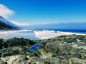
Lovely place to visit, absolutely gorgeous! Photos do not do justice, and there were so many beautiful scenes.
Some of the trails are a bit narrow and stones could be tricky to navigate for people not able to walk so well.

Easy hike
Great hike on a beautiful Easter weekend! Lots of small waterfalls that are photo worthy. The hike wasn’t too bad in the 1mile but got harder after that.

The Fiery Gizzard/Doghole Trail Loop to Ravens Point vs hiking to Foster Falls using the Doghole Trail.
Last year, at age 76, I hiked the 12.5 mi Fiery Gizzard Trail from the Tracy City Trailhead to Foster Falls parking lot, using the easier Doghole Trail. It took just over 8 hrs. In March this year, at age 77, I did the Fiery Gizzard Trail to Ravens Point, and completed the loop using the Doghole Trail. It took longer for me to complete this loop this year than it took took to hike to Foster Falls last year. The abundant rock fields on the Fiery Gizzard Trail from where it splits from Doghole Trail to where they re-connect near Ravens Point.

Great hike to the waterfall.
My father used to live near the area in Sewanee, and I used to go every trip up there, and lo and behold it's on T/A!

A beautiful hike!!
A great hike!! Be prepared to stay all day....We hiked 17 miles over a pretty strenous trail. Not for the unfit!! Make sure you take a backpack full of water, trail mix, jerky, etc. Beautiful waterfalls and overlooks that can only be seen on the trail.

Weekend Hiking in Tennessee
Had a list of places to hike and stumbled upon this trail while deciding on the next day of hiking. This place did not disappoint!

Awesome hike!
I read all the great reviews on this trail which really helped me to plan well. We camped at the CCC since we didn't have time to hike in any further. The campsites are spacious with a fire ring. Saturday we loaded our stuff back up and made the trek. The falls, swimming holes and rocks are beautiful. All the unsteady rocks are quite the workout on the ankles. Raven Point is a beautiful place to eat lunch and just hang out for a little while. We did the 10 mile loop coming out on the Dog Hole Trail. Much easier coming out than going in and up. :) We saw 2 snakes other fun critters and lots of grand daddy long legs. I will definitely go back.

Just a nice walk out to the campground. We thought about day hiking the tough part but decided against it.
We walked about 2 miles from Foster Falls parking lot to Small Wilds campground. The trail was flat all the way out tro tge campground but after the campground the trail drops.very steep. This is where the sign is telling you to go back if you are tired, running slow, or low on food or water. It should be heeded from what I saw and have read.

Challenging
Rocky and challenging. Beautiful waterfalls. Could be marked better. Watch your time so you can be out before dark. We were there the week before Thanksgiving and due to the steep topography the shadows were already getting long by mid-afternoon. We didn’t make it to Raven’s Point because we underestimated the difficulty, but the trail is so beautiful that we definitely want to try it again. Recommended for experienced hikers only.

A must see
Love this place. Especially to get to the Blue Hole. Pack a lunch and enjoy the lovely sights of Grundy Forest.

Awesome hike , and beautiful view
Don’t come here if you don’t like 6 inch 2 pound furry spiders , but great hike , beautiful views and experience , and would recommend to people like don’t mind spiders

Challenge yourself
Head a little ways outside of Chattanooga, and you'll find the Fiery Gizzard Trail. It is well worth the hike to see all the waterfalls along the way. It is not a highly traveled trail, so you just might have most of it to yourself. It has a great canopy of trees, so you won't "cook" on a summer's day. Be sure to bring bug spray because you will be in the woods for this one. We loved it!!!!

Beautiful Hike!
If you haven’t made it to the trail, you are missing out. Came here with a friend and this was instantly my favorite place to hike. It is never boring, with waterfalls at every turn, spurs to explore, rock formations, caves, swimming holes, and the list goes on. We did the Grundy Day Loop but ventured about a mile up the Gizzard past the loop. It gets more strenuous the farther you go, with rock scrambling and some steeper inclines. You are deep in the gorge for most of the loop with steep hillside on either side. Take plenty of water, wear good shoes, and be ready for a great time.
Popular Attraction Reviews


Beautiful rugged hiking adventure
The scenery is stunning & picture postcard perfect. The trails are well marked (follow the small orange signs on trees), can be very rugged. Watch for large rocks & tree trunks hidden under fallen leaves. It's a fabulous full day workout.