


Live Your Best Lives
Tiger Mountain Reviews
4.4
6 of 45 Best Attractions in Issaquah


Reviews

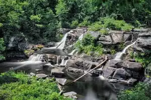
Great Views!
Great weather in early August. Great views. My boyfriend went for the paragliding and I went for the hiking. Both had a great time.

Alpine experience so close to metro Seattle
Trails abound on Tiger Mountain, only a short distance east from Issaquah. You need the Discover Pass to use the parking lots, but can avoid it by parking on the road using the High Point Rd. exit from I-90. There are options for all hiking abilities. Such a treasure to have so close to home.

One of the best places for trail running or hiking
It can get kind of steep, but the trails and views are amazing and it is never too crowded - even in summer months.

keep exploring
great mountain biking, or hiking. this area is rather large biking generally is from hwy 18 side, hiking from i90, if you flip flop those you will probably get angry looks from the other users.

First did this climb with a mountain bike, which was over my skill level. It's much more fun as a day hike. Not for the out of shape, but also great for kids that have at least a little energy.
Beautiful views from the top, and a great place for a picnic and photos.
Beware leaving valuables in your car at the bottom. This is a known car burglary zone.

Took an Unusual Trail
We went up the south side of the mountain, up the Tiger Mountain Trail. Branching off, we hiked up the south peak, which wasn't crowded at all--it looked like we were the first ones there in some time, so I highly recommend it for a secluded hike. But I've hiked this mountain a lot, and it's always been a favorite of mine.

Lots of options
Tiger mountain is gorgeous and has hiking trails extending well beyond poopoo point. Poopoo point is one of my favorite hikes but gets very crowded. Look for some of the less well known routes to enjoy nature without the crowds.

Great Hiking in Issaquah
Tiger Mountain trails are easily accessible from Seattle via Public Transportation or driving. (If you live in Issaquah you're already there) There are many trails to choose from with a wide variety of length as well as elevation gain. (From super easy to more challenging) I would recommend going online (if you've never been) and looking at all your different options, on a map.

This mountain is YUGE!
Big mountain, excellent bike trails.. Go up th trail to the summit. Come down on the Predator or Off the Grid Trail. Bring your brass balls.

Beautiful Hike!
My husband, daughter, and I hiked from the Tiger Summit Trailhead to East Tiger Summit via the gravel road, and returned via the road and turned off onto Master Link back to the parking lot. Tip: if you have the Discovery Pass, go to the upper parking lot and park.
The trip up was steep and pretty sunny. We got a fairly early start, so temperature wasn't really an issue. We hadn't really planned on such a long hike, but when we got within a mile of the top, we decided to try for it (I'm 62, and my husband is 63).
Coming down, we found the Master Link trail off to the right and entered the cool shade. The trip back down the way we'd ascended would have maybe been shorter, mile-wise, but it would have been a thigh-burner--very steep. Master Link is one way up for mountain bikers, so we had good warning time to get off the trail to yield to cyclists. It was Memorial Day, so there were a lot of folks using Master Link, but it wasn't a problem hiking down on the easy grade.
Round trip time was just over four hours for a nine mile trip. We couldn't see Seattle as a layer of clouds covered the area and the bay, but Rainier was looking pretty awesome from several viewpoints.

Tiger is Amazing
The mountain biking on Tiger is world class. Aside from a vast network of trails, the rugged nature of the mountain allows for a perfect retreat close to the city.

Keep going!
Hike the Chirico Trail. It's a fairly steep 2 miles, but the vistas are worth the effort. The first open area rewards you with a great view of Mt. Rainier. The second vista offers a beautiful view of Lake Sammamish and on a clear day you can see all the way to Seattle. If you are lucky you will see the parasailors taking off or flying overhead. Great way to spend the day!

Poo Poo Point
This is a very good hike for people that are in shape. The trail that goes up the face of Tiger Mountain is well marked and well traveled. Its an easy hike so if one suffers from knee or back problems this is not for you. In recent years, the hike has drawn more people than there is parking available for. In addition, the trail is getting way to much pressure from people wanting to take the hike.
On the plus side, the view from the top is spectacular offering an up close and personal look at Para Gliders. Take water and snacks as you will burn calories on this hike. It is windy on top so pack appropriately. There is an easier route up an old logging road but as I recall its a bit longer hike. This is a wilderness area so be aware of the critters that live there. Avoid taking animals with you as they may become food.

Get the 554 bus from central Seattle to this beautiful hiking spot.
Get off in Issaquah, opposite the City Hall, walk south on the Rainier Trail, and pick up the trail-head for PooPoo Point. There are toilets at the point but take plenty of water and some snacks. This steep track rewards you with wonderful views.

Love Tiger Mountain!
Tiger Mountain offers so much for outdoor lovers! Hiking, paragliding, dipping your feet in the lakes, streams, etc.

Not clearly marked
The passage ways are not clearly marked. We found it nearly impossible to follow the prescribed pathways.

I read several reviews on line for Tiger Trail #3 stating that this was a good beginner hike, but I would take that with a grain of salt. I am definitely a beginner (this was only my 2nd hike) and it was strenuous - I took lots of breaks to catch my breath.
The first 1.5 miles is a straight incline. The mile marker signs are contradictory and this particular weekend there was snow the last .9 mi. Up at the summit which was fairly small, the view was very underwhelming, as there was fog and couldn't see beyond about 50 feet. Maybe a good hike later in the season or when the weather is clear. Very well traveled, saw lots of folks of all ages along the way, pretty scenery. There are several trails in the area and we didn't hike the lake trail but was told by another hiker that it was more level and a nice beginner hike.
All total, it took about 3 hours to the summit. I wouldn't discourage someone from hiking it, but would classify this hike as more intermediate intensity.

Breathtaking views
We went up to watch the paragliders and had a great time. The area is pretty busy but parking was no problem. Hiking trails in the area are well maintained - nice spot to spend an afternoon.

Great!
Had a wonderful time at the mountain with our whole family and friends. Nice view, atmosphere and really memorable camping there.

Good option for winter hiking
Tiger Mountain is a great place to hike any time of year, but especially in winter when higher elevations are snow covered. The High Point trailhead offers easy walks around Tradition Lake as well as starting points for more challenging hikes. A tip is to park along the road before the gate if you don't have the Discover Pass. There is a trail from there up to the main parking lot. The road beyond the gate is ridiculously filled with potholes.

Great place to hike!
There are so many trails on Tiger Mtn. So beautiful all year. If you want an easy hike you stay on the lower trails and if you want to hike to PooPoo point for a more strenous hike. I've started at the high school trail and hiked to Poo Poo Point and walked down to the paragliding landing and parking lot. You park one car at the paragliding parking lot and drive the other car to the Issaquah High School area and take the trail from there.

Review of Lake Trail
We needed a hike for guests who wanted to see the beauty of Washington State without the physical exertion needed for many trails. The Lake Trail was a great choice. There were no steep slopes and the views were great. Even in the summer, the temperatures on the trail were moderated by tree cover. An excellent choice under the right circumstances.

Expanded trail system offers access for all
I started riding TM in the early 90's and still love the place. The parking lot is much safer and the trails are well marked there are walking trails for families at the lower levels and double black diamond trails for the experts only riders. The trails criss cross the main road so it's nearly impossible to get lost. The ole' standby, Preston-Railroad trail is still my favorite. The main road to the top is shared by bikers and hikers. It's annoying when stupid people use this as an Off-Lead park for their dogs, needless to say it's also dangerous for riders and the dogs! arrrrg! bring plenty of water on your excursion, there's no watering stations or shelter.

Beautiful Drive
The drive from Sea Tac through Kent, Auburn and Enumclaw is so breath taking! I would recommend going south on 167 to Auburn and then taking 164 South and East to Enumclaw. You can see Mount Ranier the entire drive! There are places along the way to stop and eat too

Beautiful
Many beautiful trails ..look for the bus but watch out for bears! Be sure to sign in at the trailhead and get a map.

great hikes with great views
has some great trails for a good day of hiking. You'll be rewarded with some great views at the top.

Worth the trail
It's two hrs hike. Elevation would be 3000 FT once you hit the summit. Very calm hike with not too many annoying people around you.

Tiger Mountain - Hiking and Biking
A great place to do hiking and mountain biking. The eastern peak of the Issaquah Alps has everything from paragliding off Poo Poo Point to hiking the West Summit, Lake Tradition and many, many miles of great mountain biking.

The sky is the limit as to the number of options for hiking trails and total mileage, all walking distance from my home in Newcastle. Well maintained trails and something for every age and ability. Look for mines, look at the scenery, look for history, look around and if you aren't careful , you can find your car in Newcastle and yourself in Issaquah! The trails are good for walking and running, carry water and snacks and your phone.

Steep hike, but worth the effort
We hiked to poo poo point which is steep all the way up and down (but not steep that you need to climb down on your butt, but need definitely a good pair of hiking boots). Still the climb is worth it for the view. You can also see paragliders in summer time.

Challenging for the person who hikes only 3-4 times a year but a gorgeous and great workout with the reward of a gorgeous view at the end!

We hike Tiger Mountain every Thursday night. By all the cars at the trailhead, it would seem like a crowded trail, but we seem to pass few groups. Roundtrip, the hike takes about 1.5-2 hours. There are lots of switchbacks and the grade is very doable for a beginner or as first hike of the season. By the time you get to the top, the grade is steeper, but you are warmed up, so it's not too killer. The view is South West. Along the way you get views through the trees East and then West.
People park outside of the gate instead of right at the trailhead because the gate closes at dusk. If you park outside the gate, expect a 1/4 mile walk on the gravel road to the trailhead/picnic area.
elevation gain: 2000+ feet
distrance: 5.2 miles round-trip
Dogs: OK - should be leashed, but none that I saw were.
Directions: From Seattle, drive east on I-90 to Exit 20, High Point Road. Take a right, and then another quick right, following the sign for Tradition Lake Trailhead. The gate is open seven days a week dawn-8 p.m.

Great place to get a little picnic nooky
Take your gal, hike up to the picnic tables and on some late afternoons, you've got the place for yourself...all in all, great spot for romance and picnicing.

I'm local and love this.
There are many trails that interconnect, so there are a lot of time choices. It does get crowded on week-ends because it is convenient. These hikes are great for Fall and Spring, when I do not see many hikers. And, the "trail runners" tend to use only the steep and well used trails. Dogs are supposed to be on a leash. Looking forward to the new latrines being fully installed.

TIger Mountain is and easy trail
Tiger mountain is an easy trail, best to do mid week early morning to avoid the crowds. Through the years the view from the top is almost not existent, which makes the hike not so interesting.

Views All Around
Great hikes in a setting that is beautiful, calming and can be challenging. There are lots of hikes to choose from that fits almost everyone's needs - from a flat and easy stroll to a challenging 1000 foot vertical straight up the power line trail. Weekends, when the weather is nice can be busy but worth the trip.

Family Hike Day.....
Great area to hike. Took the kids and they also enjoyed it. Will be going again! Trails are marked clearly with distance on them. We saw a lot of mountain bikers also, so if you like to mountain bike this would be a good place to go.

Terrific for a Family Hike Near Seattle
Tiger Mountain was always a favorite for my family as we raised three lively sons. The trails are a mix of very easy to slightly challenging. And there are many surprises to be found on various trails. The Talus Caves (caves made from a long-ago rock slide that left holes between the rocks to climb through) were always a target for our hikes when the kids were young. The cave entrances were just the right size for the boys but too small for dad - so leaving was sometimes like a game of "Whack a Mole" - just when you think you've got them out another head pops up from another hole and you are back on the chase.
If you are adventurous enough to make it all the way to the top of Tiger Mountain you are rewarded with a great territorial view, including nearby Cougar Mountain. With the winds blowing on the gentle South slope its a great treat to lay there and take inventory of all the cloud animals as they pass over you. Plenty of fauna and animals around to do some environmental training. A few fun creeks to temporarily dam to teach early engineering skills.
All-in-all a really fun place for a family outing. It also works as a great get-away hike when the opportunity presents itself and you don't want to go on a long drive to a trail head. Enjoy

Beautiful Hike and Paragliders
Tiger Mountain is a really great place for a strenuous and rewarding hike. The trailheads are close to Seattle, about a half hour away on I-90. Tiger Mountain is a state nature preserve in the foothills of the Cascades. It's part of the 'Issaquah Alps', the set of three or so small mountains that ring the once small, rural town of Issaquah. Issaquah is now a bedroom community for Seattle, but retains its charm and beauty, and hiking.
The trail leads through second growth forest with some very large trees, and typical Cascade vegetation. We hiked on a sunny, cold day and were delighted with the way the sun's rays shone down through the trees into the dark forest. It's a two thousand foot climb in about 4 miles, which is a good workout. It took us two hours to get up and one to come back down.
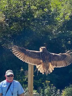
Our destination was Poo Poo Point, a world-renowned paragliding and hang gliding destination. There must have been good conditions for paragliding because they were lined up to launch at the top for as long as we stayed there watching. At one point we counted 25 in the air at the same time, circling in the updrafts together with the birds. It was a majestic site!
There's a little known trailhead on Second Ave in Issaquah. Take Front Street south, past the downtown area toward Maple Valley. Watch for a traffic signal at Second Ave and then a small parking lot immediately on the right. There's room for about six cars. From there hike in and take the first right and on up. The trails are well marked with signs.

Great hike
When to the top. Trail in good shape. Not too strenuous but a fair amount of vertical. Most of walk is under canopy of leaves. Very pleasant.

Nice hike
This is very scenic with trails offering different levels of difficulty. There is a lot of scenic beauty along the trail and the summit is incredible.

not as moderate as stated
Beautiful hike through the forest. Lots of uphill going up the mountain and not as moderate as some state. Very peaceful and when you get to the top of poo poo hill the views are fantastic. Even saw some parasailers this day. Took us about 3 hours round trip. 3.7 miles up and 3.7 miles back. Walking stick sure helped coming down the mountain

Summer Vacation
Do this hike all the way to the top of this mountain. Breathtaking views. Great place to take amazing pictures. The hike takes a good 45 min to an hour to get up but it's beautiful all the way up. Parking is free but limited so get there early and bring plenty of water.

How do you rate a mountain?
I live at the edge of Tiger Mountain, it is beautiful. There are lots of maintained trails you can access for hiking. Some are more crowded than others so check for reviews online or read a guidebook to see all your options. Lots of people default to just certain trails but there are many choices.

With many lovely hikes, varied terrain and occasional great views, TIger Mountain is a great way to spend a morning.

Beautiful view of Mount Rainier from the top
My SO and I are in really good shape and work out daily and it took us a little over an hour to get to the top. The walk has tons of switchbacks but is not extremely challenging, it just takes a while to get to the top. We climbed camelback mountain the month before and it was nothing for us compared to that climb. This hike is defiantly worth it because the view of Mount Rainier from the top is breathtaking! They have multiple trails that you can take, bikes can be on the same trail on the way up but on the way down they have a separete trail that they take which is nice. I would suggest going early in the morning to beat the crowd and heat if it is summer time. Parking was not the best here. There is parking right when you pull in and that was the only place that we found to park. After asking around most of those other areas required a parking pass. You have to walk just over a half mile to get to the actual trail from the free parking lot.

Good hiking that is frequently overlooked
In the spring while Snoqualamie pass trails are still under snow fields, Tiger offers some challenging trails with views and boulder fields close to Seattle. Wildflowers start in April-May. There are moderate trails also with quite a few geocaches.

Great, challenging half-day hike.
We hiked up Tiger Mountain Trail about 7 miles round trip. The well marked trail took us by gorgeous scenery, and beautiful views. Old growth forests, streams, even the logged areas had breathtaking views. We saw lots of wildlife including a bear. Take water and snacks. Dress in layers. As you get to the top of Tiger peak the trail becomes very steep. There aren't any vistas at the peak, but the trip is worth it for the scenery along the way.

This park owes its orgin to the Washington State DNR, and conservationists who prevented it from being a large housing development. Miles of wonderful hiking and mountain biking. Always something new to see, all year around. Download maps before venturing into the park. Great view from the on top of Tiger Mountain, as well.

Tiger Mountain has a lovely hiking trail which is occasionally in the clouds, which makes it even more fun...the trail is a great family activity...just pack some lunch and water....you will find it well worth yr time....and efforts.

Hundreds of Miles of Pristine Mountain Trials
Tiger Mtn is awesome. You can start at one of the several trailheads and keep walking/exploring for days (if you'd like). The trail system is very well maintained and connects to other mountain systems. You can hike, mountain bike, run, and watch wildlife. Best part: you can jog/run/bike out of Tiger Mtn and often you are just a few blocks from a cold beer and dinner. Bears, cougars, owls, deer, and bobcats live/travel here along with many other wild creatures. Check out the Issaquah Alps trail community for tours and volunteer opportunities.

Great spot for a hike or Mt Bike ride!
There are tones of trails on all sides of Tiger Mt and depending which one you take there are fantastic views of Mt Rainier to the south or Lake Sammamish to the North West.

Great hike for the fall
Short and steep, the fall is a great time to hike Tiger Mountain. Parking at the trailhead is possible and the overwhelming crowds have dropped to a reasonable amount.

Tiger Trail #3 - Not much view from the top
If you take this trail to the first view point (based on the sign), you will be disappointed. It says there is a view but I hiked with my wife and kids for over 3 miles up hill only to discover that you couldn't see anything from there. Later someone explained to us that there is another peak at Tiger that does have awesome views but it's not at the top of Tiger Trail #3 so just be aware.

Watching the paragliders
This is an amazing hike, pretty steep, and it takes about 1.5 hours constant uphill. At the top you will see amazing views of Mt Rainier on one side, and continue up 5 more minutes to watch paragliders smoothly transition off the mountain and into the sky above Issaquah, with Bellevue in the background. Amazing!

Close In Gem
I hike there about once a week. It is convenient. There is plenty of parking during the week. I don't go there on the weekends. Pick your hike or or walk--there is something for everyone. A Discover Pass is needed for the trailhead at High Point.

Happy Trails
I can't really hike any more, but the trails on this mountain are quite inviting. The trip to the top can be pretty rigorous for inexperienced hikers, but it's not necessary to go all the way to the top.

Simple hikes for all ranges of hikers. Some great views on the right trails.
Hike through some great second-growth forest to reach the second highest summit (West Tiger #1) in the Tigers. Then enjoy a superb viewpoint a short distance west of the #1 summit.
Tiger offers trails for all levels. Nearly level trails to the Cable Line Trail climbing over 2,000 feet in just 1.5 miles to the summit of West Tiger 3 for a challenge.
I did West Tiger #2 and #1 in a 10 mile loop on an uncrowded weekday. Weekends can be jammed.

A Beautiful Place for all levels of hikers.
I am in my mid 70's, so I only took the around-the-lake trail with a short excursion up the bus trail. However, it gave me so many beautiful views in that short distance. Plus, I saw a colorful slug along the trail. My daughter has used all of the trails including the most difficult to the top, and it is also a favorite of hers.

Lots of beautiful trails
Tiger mountain is very accessible from Seattle although some of the trailhead parking can be packed on nice days. Lots of well-signed trails but I’d recommend downloading a free map before heading out.

Take the High Point Way exit for an amazing network of trails around Tiger Mountain. Be sure to bring either a map or a pencil & paper for sketching your way back, because it can be easy to get lost! The hike to the top is a strenuous workout that's well worth the effort, with views stretching over Seattle out to the Olympic Peninsula. For less ambitious hikers, The Talus Rocks (formerly the Talus Caves, but now closed to adventurers) is a nice, family-friendly picnicking hike.

Beautiful hikes for all levels of hikers. Whether you just want a stroll around a nice lake or a rigorous hike up a mountain, this is the place for you.

Great walk
Very easy trail in the woods, away from the city, just 40 minutes drive from downtown.
Perfect walk for children an elderly people

Such beauty
Our kids loved this hike! The trail is beautiful, and not too hard while carrying a child. I would like to go back with just the husband.

challenging hikes
Tiger Mountain is full of trails of all levels for hiking. My favorites are the trails leading to Poo-Poo Point, where the paragliders take-off. The Chirico Trail takes off from the paragliders' landing spot on Issaquah-Hobart Road and pretty much goes straight up (switchbacks) to the top. Very good athletes can do it in less than 1/2 hour, but beginner hikers should expect the hike up to take over an hour (maybe even two), with several stops to rest on the way. Most of the trail is covered with tree canopy, thus shady. There are not really any views on the way up, until you make it to the first clearing which faces southwest toward Mount Rainier. If you get to the top and the main take-off field on a clear day, the views from there are amazing (Issaquah, Bellevue, Lake Sammamish, Olympic Mountains...). If you are lucky in the afternoon, you may get to see paragliders taking off. There are simple bathroom facilities at the top. The trail can be very busy on the nicer days, so I feel rather safe doing the hike alone (I am female). Even on horrible weather days, there are usually some dedicated souls hiking to the top. The way down goes much faster, but is hard on the knees.

The hike to the top of Tiger Mountain takes a few hours and is lovely if you are looking for a walk in the area that is not too challenging. The only downside is that you do not get any vista's during the hike - only at the top.

Trail to Poo Poo Point
I checked out the longer route to Poo Poo Point today - my first time. Parking was a little tough to find - there is a small unmarked lot on 2nd Street just off of Front Street. The trail varies between level and steady climbing. The surface is mostly good, with smooth rocks scattered about. On my way back, I got caught in a sleet and rainstorm. The trail does not drain all that well, although it was not particularly muddy either, thanks to the rocky surface. Total distance using this route is about 8 miles round trip.

A Seattle-area Standard
Probably the most heavily travelled 2000 vertical feet in the region, Tiger has innumerable trails ranging from flat to straight up! I try to hike it once a week, and though it is very familiar, there are always new things to find and experience. Most begin from the Tradition Lake trailhead at the Highpoint Way exit from I-90. You need a DNR Discovery Pass to park in the dirt lot, but many folks park on the pavement just outside the gate where permits are not required.

A playground for all ages just off the interstate
I have it easy: I live within a block of a Tiger Mountain trailhead, so I'm up there nearly every day with my dog or a friend. But since it's about a 15 minute drive (not in rush hour) from downtown Seattle, and is accessible by the Sound Transit 554 bus, anyone can enjoy the wonders of Tiger.
There are trails for every kind of hiker, from flat strolls along the Tradition Lake Trail (off Exit 20), to long, loop hikes (last spring I took a "9-5" hike and went about 18 miles) that traverse mossy woods, endless berry bushes (in season) and offer amazing views from the many peaks along the long ridge. Most of the trails are accessible all year round, although the upper reaches can be beautifully snowy from late fall to early spring. And best of all: there are 90 MILES of trails, so you have endless exploration possibilities.
I recommend finding the less traveled hikes that don't have hordes of people, or going on a weekday if you like quiet and solitude. Maybe I'll see you on the trail!

Hiking
This can either be an easy or an incredibly difficult hike. It is beautiful and we have always seen critters. Also a great place to geocache. My grandon found his first there

Chirico Trail up Tiger
Made it to the trail from Seattle by taking the 554 Sound Transit bus to Issaquah. (Get off the stop after the Transit Center)
Around a mile and a half walk along the Issaquah Hobart road going south to the trailhead. The trail - Nice pretty relentless climb with few flat stretches but pretty well maintained given the heavy foot traffic. Several switchbacks to the top with snow on the trail increasing till deep at the top. Spectacular views of the parasailing taking off from the snowy plateau. Well worth doing though a cardio test take advantage of the great dollar store in Issaquah for a great range of trail snacks and drinks.

Beautiful hike
We decided to explore Tiger Mountain from the High Point entrance, hiking up the trail from the main parking lot rather than get the Discovery Pass to drive up to the lot closer to trail entrances. Even after a wet week in Seattle (first week of November), the trail wasn't too muddy. Then after arriving at the trailheads, we decided to hike the Tradition Lake trail and then take the Powerline trail for a complete hike around the lake. The weather was beautiful. There were a few people out, many with dogs (on leashes). It's nice to see a place where you can take your dogs and I was wishing I had mine with me at the time. Good birdwatching spots at certain spots along the lake as well.

Stunning Vistas as a reward for a great hike
Many routes to traverse to hike Tiger. My favorite is the one from the paraglider take-off area on Issaquah-Hobart Road. The hike is all up-hill with no breaks, but the vistas at the top are unbeatable. Sit and enjoy your hiking snack while watching the paragliders take off, framed by the beautiful views over Issaquah and way beyond. Amazing suburban hiking experience.

Tiger Mountain Round about
Tiger mountain offers multiple hiking options for all levels of hikers, from the flat family friendly trails on the Tradition Lake Plateau to a number of more strenuous hikes that you can link together to the numerous summits that comprise Tiger Mountain. The best views can be found at Poo Poo Point, West Tiger 1 and East Tiger Mountain. This paticular hike was a great all day hike, perfect for an intermediate hiker that likes exploring both the popular trails and ones you get all to yourself. Began at the Chirico trail head. This trail head has exploded in popularity so parking can be a challenge. It is also where the Paragliders land. There are three Portable Toilets at the parking lot. The Chirico Trial rises at a steady grade and is quite popular. The trails ends at Poo Poo point where the views of Lake Sammamish, Bellevue and even Mt Baker are spectacular. It is also the take off point for the Paragliders. There is a restroom just off the Point. From the point, head east on the Poo Poo Point trail until the junction with the One View Trail. Once on the One View Trail, solitude abounts. Take the trail for about a mile, linking up with the Tiger Mtn Trail (TMT). Contiune east on the TMT on an easy farily level trail, with broken views to the south. At the Paw Print Rest stop, the Paw Print Connector goes north east begining on a logging road and ends in a nicely forested area where the junction with the Bootleg trail can be found. Take the Upper Bootleg trail and in a little over a mile your at one of the best lunch spots on the mountain, West Tiger 1. Mt Rainier, Seattle, the Olympics and the Paragliders off in the distance, are just some of the views. There is a bench to sit on and soak in the views. From there it is down the access road and through the gate that is marked No Trespassing to the road to West Tiger 2 (To your right is the trail sign). Views from West Tiger 2 are more filtered. From West Tiger 2, the trail to West Tiger 3 is a little hard to see as its just shy of the summit. Take that trail to the junction with the TMT and they take a left on the TMT, back to the One View trail. A right on the One view trail and within a mile your back to the Poo Poo Point Trail. Take a break at Poo Poo Point, and watch the Paragliders saoring over the area before heading back down the Chirico trail. The hike is pretty much accessible year round and the trails are in great condition.

Hiking to a view!
Great place to train for mountaineering or just get some exercise at a more moderate pace. Takes me about 1 1/2 hrs to get to top & 1 hr to come down. Parking can be a bear. Go at off times or bring $5 cash for ad hock parking down the road. Views are wonderful. Can bring food and hang out, watching the paragliders jump off the top. There are 2 views - the 1st is of Mt. Rainier (on clear days) & the 2nd is of the Issaquah valley. A must see & do activity!

This was one of the most amazing experiences ever!
Mark was an amazing instructor and awesome to fly tandem with! I can not say enough how incredible this experience was! Take yourself to the next level and do this! Great flight club, great instruction, great flight, and great well deserved beer awarded at the end!!! Thank you to Mark and his team!!!!!! Will be doing this again!

Beware the access road!
DNR has a terrible time keeping up with the maintenance needs on the road into the parking lot. Even folks with Discover Passes (which are necessary only if you park beyond the gate) are filling up the paved portion of the access road now. The pot-holes re-appear within weeks of the periodic grading of the road beyond the pavement, and have become so deep my frame scrapes regardless of the path chosen. Yeah, the parking lot is overflowing on the weekends with people who have paid the state for the privilege, so it would seem some of those $$$ could be brought back here to do more than simply running a grader over the road, a job that never does more than temporarily filling the holes with loose gravel. I love Tiger, and am up it weekly in my attempt to stay in shape, but I sure wish DNR and Issaquah would take note of its well-deserved popularity and pave the last few hundred yards into the parking lot.

Endless beauty
The only downside to this fabulous series of trails is how close it is to the city and thus more populated. However, if I lived in the city (and not adjacent to the mountain) that would be a huge plus. Share the trails and enjoy!

Great Area for Hiking
Tiger Mountain, just east of Issaquah is a great place to hike, with a variety of trails for all levels of experience and abilities. If you choose to hike to the top, the views are splendid. This can be busy on the weekends but great of a quick hike after work, for a summer's evening.

The hike was steep but good when we got to the top we watched hang gliders taking off from the summitt which was very cool.
Popular Attraction Reviews


Not too far from town
It's an medium difficulty trail east of Seattle. I'd say try Rattle Snake Trail (swim in summer too) or Cougar Mountain for easy trail in Issaquah.