


Live Your Best Lives
Tom's Thumb Trailhead Reviews
4.8
2 of 226 Best Attractions in Scottsdale


Reviews

Nice, varied trail!
Loved that there were ups, downs and flat land. Beautiful scenery. Lots of rock formations to imagine shapes in. Great hike!

Quiet, well maintained
This hike is about a half hour drive from North Scottsdale and easy to find following google maps. There is plenty of parking at the trail head as well as pit toilets but no water. 4.2 miles from car to Tom's thumb and back. Took 2 hours and 20 minutes with a 20 minute stop at the thumb. The first 1/4 mile is a gradual ascent up a gravel path. The next mile is steep switchbacks. After that it's a much more gradual ascent through the boulders to Tom's thumb. The trail is well traveled, well maintained and well marked, with signs at each of the many junctions with other trails. A very nice, quiet alternative to camelback mountain.

Great hike
Great terrain. Picturesque.Our hike was just about 4 miles-two in and two out. My phone indicated 14 floors,so there are quite a few terrain changes.

Beautiful every time you climb it !
We always make a point of hiking it a couple of times when we are in the Scottsdale area . The trail is a bit of workout , but slow and easy wins the race . The rock formations are especially beautiful at the top , and we were fortunate to see some Desert wildflowers . Well marked trail and usually lots of folks hiking this trail . This year it snowed and they closed this trail for a few days . Hard to believe ..

Excellent Hike on Tom's Thumb Trail
This trail is wonderful. The scenic view was spectacular and the people we met were friendly and helpful.

Great Hike with Amazing Views
We are visiting Arizona for a few weeks and decided to take on this hike. We went the easy route but this hike will take your breath away in terms is beauty and hike impact. We went early in the morning and it was a bit on the chilly side this time of the year. We found many hikers on our way up. Wear shoes with great traction and take it easy. It is a fast climb well worth the effort. Highly recommended.

Great Views!
And a bit of stairclimber to get there. Busy trail, start early. Lots of dogs on a weekday, all on leashes.
Every other review has more advice so I'm not going to repeat any other reviews except to say, "Their pulled pork & chicken is to die for!"

Tom Thumb in the usn
Got up early and headed to 5he Tom’s Thumb Trialhead. Bring water, bring water. Met a lot of great people on the trial. Crested at 8am, back at the trialhead at 8:41am. Note: when going to the trailhead using gps, watch the signs. The gps will take you into a development.

Short hike with 360 views
It is hard. Do not be fooled by short distance. It is all up hill 1300' in about 2 miles! Typical Arizona views from the top. As other have said it's hot, no shade or water, loose gravel... be prepared. We hike about 250 miles annually, this will be difficult if not up to it.

Killer hike
Outstanding hike. Clean views. Beautiful rock formations everywhere. Nothing looks the same as you weave up and down back and forth. Pretty steep climb but nothing too hard if your in decent shape. Really loved this one.

Good hike.
Probably a 6.5 out of 10 difficulty for the average hiker. Very clean facilities, be aware there’s no water here. Trail maintained, marked, and mapped all very well. Slightly nosy volunteer on premises for questions, there was a skirmish between him and a few hikers coming off the trail with a dog. Temps were cooler than town, and nice and breezy at the top.

Great hike anytime of the year
This is one of my favorite hikes. Great workout. Definitely consider this an intermediate hike. Good gradual vertical climb. Dog friendly. No water at the trailhead but they do have restroom facilities.

Great Hike
This is one of my favorite hikes in the Phoenix area. Fairly steep going up but not a "stairstepper" like some hikes are. The views at the top are spectacular. If you go beyond the "thumb" to lookout point you'll find another scenic viewpoint you shouldn't miss. Wear sturdy shoes with good grip on the bottom, the lose gravel can be slippery.

Outstanding challenge within minutes of North Scottsdale.
Tom's Thumb is accessible from several trailheads. I have always entered from the Tom's Thumb trailhead, behind the McDowell's, so to speak. One enters via Happy Valley Rd, passing the turnoff for Pinnacle Peak, heading NE towards 124th Street. Brown signs guide you to the trailhead, which has ample parking.
Your hike begins with a gently sloped compacted gravel walk, shortly gaining slope and altitude with multiple switchbacks. An easy stroll midway through a 'saddle' of canyons leads to a steeper ascent through amazing rock structures. The Thumb itself has great views, split rock cave formations and great photo ops.
Returning, consider looking for a geocache, the Ogre's Den (or Miner's Cave). Don't forget to sign the logbook!
Bring at least two large water bottles.
Rating: Moderately difficult.

Great hike and lovely views!
Although the trailhead requires a longer drive to get to, it is worth it to be on the 'backside' of the McDowell range. As you hike this trail you start at a moderate uphill and then have a series of switchbacks that require a bit more stamina. The last third of the hike is more moderate as you go across a ridge with spectacular views. This hike is much less crowded than Pinnacle Peak or other hikes closer to Scottsdale. We heard about a rattlesnake on the trail but didn't see it, but did get to see a Gila Monster between some rocks! The other trail at this trailhead (Marcus Landslide Trail) is much less uphill and differnt topography but also worthwhile with interpretive signs and great views over the Verde Valley as well!

Tom's Thumb Hiking
I've hiked trails in Tom's Thumb Trail area a number of times. Tom's Thumb Trail area offers a wide selection of trials from easy to challenging. The views of the valley are wonderful. The easier hiking trails are conducive for hiking with your dog. Bring an adequate supply of water.

Challenging but well worth the effort
I was definitely impressed with this trail for a number of reasons. First, it's challenging. Second, the views are beautiful. Finally, the trails are well marked (except for where Tom's thumb actually is) and easy to follow.
I saw other reviewers say it take about two hours, but it can be done quicker than that if you are looking for a real workout and willing to do some jogging. My brother and I (36 and 31) jogged about 80% of the trail and it took us around an hour and a half. That included a few stops for the scenery and a little backtracking at the top to find Tom's Thumb. The way down took us about 25-30min. We were sweating like crazy and it was about 60-65 degrees! My legs were a little sore the next day-we definitely pushed ourselves. The trail itself has a lot of rocky sand and not too many bigger rocks to navigate-it's a lot less technical than something like Camelback.

Great hike! Awesome views
Great hike! Be aware no water available at trailhead (although they have the nicest composting toilets I have ever seen). Also, there is a significant uphill climb and then it levels off a bit. We went on to the Lookout which was nice because most people turn around at the thumb. Much less crowded and a GREAT view. Drawbacks: despite multiple signs instructing dog owners to pick up poop (“there is no poop fairy”) there was a significant amount of dog poop on the trail, some of it bagged (I don’t get it….)

Fun hike
We took the easier loop as our group had a large age range. The trail is well maintained and well marked. The varieties of cactus were intriguing. Just remember the teddy bear cholla is not huggable. haha. One of our party accidentally brushed up lightly against one and we had to remove a few needles. Nothing serious. The views are spectacular. If you enjoy hiking, put this one on your to-do list!

Easy access, various levels, descriptive markers
What a pretty drive from the Scottsdale area! The trails are well-marked with a variety of difficulty and trail lengths. Clean bathrooms. Gorgeous AZ landscapes and cool markers explaining the terrain and history. I am 58 and in decent shape and did a med-difficulty hike. It was easy and super fun.

Great afternoon hike, but not for the faint of heart.
This is a fun afternoon hike. The desert views are wonderful. Go later in the afternoon so you get the late afternoon light for great desert pictures. Be aware, this hike is somewhat strenuous.

Well marked trails with great site markers
The road up to the start of the trail is more fun to ride a bicycle on than you can imagine! I did that a few times alone, and in the end, we drove up and parked, for free.
There is a giant map to help you decide which trail to go on. Clearly marked. We chose the Marcus Landslide Trail. There is an extra 1 mile loop, worth the ups and down if you can hike like that, not flat and we worked up a sweat. Two great features, the trail was clearly marked, never any doubt and there were permanent explanation markers to give detail into what you are looking at.
We had water, there is none available.
There is a bathroom, an enclosed outhouse, we did not use.
Our trail was considered moderate. You need to be able to go up, at an easy pace this is a great trail to work up a little sweat.

Exciting challenge
We loved our hike up to Tom's Thumb. The scenery is out of this world. The hike is strenuous, but absolutely worth the effort. It is important to watch for the signs so you take the right path to Tom's Thumb. It is a small dirt path at the beginning. It would be easy to miss. You also have to be careful coming back from the Thumb. We know people who turned right instead of left when they arrived at the end of that same dirt path.

Has a little tough start - but gets better
This was my first hike in this part of the world - and I went with a great gang of gals, who had already done this hike earlier. We started early (around 7 am). The hike starts a bit tough but got better in the second half. Loved the views from the top and on the way up/down. Do carry some light snack and a bottle during the hike.

Amazing views!!!
Wonderful hiking trails and amazing pay-off at the top with views that continue to get better and better as you go up. This is not a hike for novice hikers and you need stamina to get to the top. Pack lots of water and some snacks.

Tom's Thumb Trail
It is not a very difficult hike, I passed many families on the trail. I was able to hike in my running shoes . I hiked 4 1/2 miles and it took 1hr and 45 mins. That was with photo breaks. Bathroom's were clean and parking lot is big. There is no water available!!

Nice hiking area
Nice hiking area. Intermediate difficulty. Views from the top are exceptional. Worth the trip. Give it a try.

Awesome views!
The switch backs up the face of the mountain are very strenuous but if you take them slow and rest when you need to anyone can brave this trail. After the initial assent up the switch backs the trail is much less strenuous. Talke plenty of water. This trail is dog friendly buy you must have a leash.

Exceptional Brisket
Great brisket with an arrange of sauces, some were super spicy and others were more tart or sweet. I love the choices with either lean or fatter pieces to choose from. Great patio as well!

109 Flights of Fun
We are from a very flat land (Illinois) this hike was full of elevation challenges but reaching the top was a great feeling. Smooth path, nice views especially as the flowers were just starting to bloom.

One of Scottsdale's best hikes --- worth the climb!
If the giant granite boulders in the north McDowell Mountains capture your explorer DNA, you are going to enjoy the Tom’s Thumb trail. This 5-mile round trip takes you steadily uphill 1000 feet, through hillside scenery like a movie setting: huge granite boulders tumbled together with saguaro cactus, desert bushes and (at this time of year) tall grasses and spring flowers. We’ve not had much rain in early 2016 so right now the flowers are few.
A different view is around every corner. The trail is wide and well maintained. Moderately steep switchbacks are interlaced with flat saddles crossing hilltops for a chance to catch your breath and enjoy this unique scenery.
After 60 minutes, you'll reach another saddle overlooking a distinctive bowl-like area, where the East End trail intersects with Tom’s Thumb trail. Stay on the wider, well-marked Tom’s Thumb towards the right and in another half mile you’ll reach this iconic Scottsdale landmark (Tom’s Thumb is the second of the two granite towers ahead of you).
A trekking pole comes in handy on the downhill return where a few steep areas have loose pea-size gravel.
The access road to the trailhead is paved and there is lots of parking. The large trailhead facility is covered, providing welcome shade. There are bathrooms with compost toilets but no running water is available; carry what you’ll need. Free trail maps are plentiful. There are excellent interpretive displays that describe the geology of this area.

Difficult trail which I could not do,but other active family members loved.
This is a beautiful area with lots of interesting trails. Tom's Thumb is too hard for me (76 years old with bad knees) but other family members have done it in the past.

Great Trail
We had a great hike on this trail. As others have posted there are some steep parts & wearing hiking shoes definitely work better then regular tennis shoes. Lastly bring plenty of water.

Beautiful hike!
Hit up this hike during our first visit to Arizona. Beautiful hike, challenging at times, but worth the trek. Easy to follow trail. Bring lots of water.

Nice hike!
Great hike, and can either be challenging or easy depending on your hiking level. The first half is steep uphill switchbacks, which is the most difficult part. The second half is more rambling, still climbing up but not as steep. Pause at Vulture View for a good breather if you need it. People were running and walking, each at their own pace. The top was closed off, which was a little anti-climactic, but a nice day all together. There are restrooms at the entrance but no water; hand sanitizer in the restroom.

Beautiful
Beautiful area! Very nice to get out of the city. This was my first visit. There were some guides there to answer questions. There were also restrooms, not port-a-potties. Will definitely go again.

Great Hike
At the parking lot there is a trail map of the area although you wouldn't need it to get to Tom's Thumb as the trail is very well marked. Restrooms available.
The climb is a bit of a slog as it's quite steep but if you take your time and stop to enjoy the views (aka catch your breath), you'll be just fine. Hiking poles for me were really helpful.
It's an interesting climb through rock formations.
The volunteer told us at the bottom that at 1 p.m. there is a large fountain that goes off at 1 p.m. (and perhaps every hour on the hour) in the Valley -- once you've made it to the top, walk for a bit, you'll see the East Trail marker - the fountain is in the valley below. We were lucky enough to see it.
As you get closer to Tom's Thumb you'll see a marker for the East Trail -- some locals told us to walk down it for 5 minutes to get views of the valley and cactus. We did this and it was worth the short diversion to see different scenery.
This hike is definitely worth the effort.

Great Scenery-Tough Climb
This is a tough trail but the scenery was great as far as we got on this occasion, our second visit. It is an 8 KM round trip walk and a climb up 410 meters which after 7 KM on the Marcus Landslide Trail was just too much on this occasion. The views back across the Verde valley and the Superstition's was excellent

Quick and Steep.
The trail is nice and steep—gets your heart pounding. It is pretty crowded on weekends. Good parking and many connector trails to make it a longer adventure.

The workout!
This trail will take most of two hours and have plenty of mountain views. It is not for the casual flat walker. The trail winds back and forth as it works it way to the top and beautiful views.

Top O' The Heap, Scottsdale VIEWS unprecedented.
Imagine the McDowell Mountains of Scottsdale twice as high as they are now. Now imagine that you are on TOP of that mountain, and can see for fifty miles or so. If you can see this in your mind's eye, you are standing atop the highest rocky crag in this part of the world. It ain't THAT high, you can hike (rigorous) to the top of this granite monolith, up and down in an afternoon. Take plenty of water and be sure to pee before you embark, there are no facilities on this rugged trail. But the view is worth it, so says my son who took his mountain bike to the top! If you wanna see the top, this is it!

Great volunteer interaction
The trailhead is very nice. The route to the “thumb” is somewhat challenging but there are sufficient “resting” areas to allow others proceed. Great views and a wonderful trail.

Great for avid hikers
Beautiful area to hike especially in the winter & spring (summers can get really hot so go EARLY!) There's also an area for experienced rock climbers/rappelling.

Thumbs up for Tom’s Thumb!
Family of 4 (kids 7 & 10) made it to the top and back down in about 2.5 hours. Tough hike up but worth the gorgeous view from the top! Made for great photos too! This is a must do on a trip to Phoenix!

Nice trail- bad signage
This is a good easy trail.
The sign telling you the trail is
Straight ahead is placed at the wrong place. It should be right before e. Alamadea rd instead of just after.

Huff and Puff Hill
What an adventure. Jack the guide at the begining of the trail gave us great information about the elevation and type of shoes needed. There are two trails one easy and one with elevation. Both are beautiful and Jack can give you information on which one is right for you.

Hiking-very good
You may see rattlesnakes here but just don't get them mad. Bring your camera for the views. Heck bring your camera to EVERY hiking trail in AZ. Bring water, sunscreen and a hat and I also bring gloves to protect my hands. Did I mention shoes?? BE smart!

Steep climb with excellent views
Scottsdale bought thousands of acres of land in an area called the Preserve. Tom's Thumb is part of this. It is in the north end of Scottsdale and is surrounded by pristine desert. Not at all like hiking Camelback in the middle of the city. It is not crowded like Camelback or nearby Pinnacle Peak. The trailhead has a bathroom but no running water. The trail is steep so be prepared for a good hike, but the views are amazing. It is pet friendly. If you think it is too steep the is a trail that loops around the bottom of it that is flat and lovely, with boulders that are mingled in it. It also has nice views. You can get directions on Google maps. It is approx. Pima and Dynamite, near Pinnacle Peak.

Second favorite Hike in the valley.
So much better than the crowded Camelback trail. Loved the view of the fountain in Fountains Hills. Nice workout

Great hike
Medium intensity and dog friendly. An advantage is that its not too busy during the week. Beautiful vistas from the top.

Big rocks!
Not much to add to all that's been written. Landscape here very different from Tucson (very few saguaro cacti). Late March, lots of poppies blooming. Awesome rocks, reminds me of the northern border of Joshua Tree a bit, or Texas Canyon near Tucson, or the mountains along I-8 between Yuma and San Diego (In-Ko-Pah). Not far from North Scottsdale so if staying near Kierland, great way to see some beautiful desert scenery, get a workout, a half day adventure.

Effort Pays Off
I hiked this trail with my sons. We all agreed of the trails we hiked, this was our favorite. It is challenged enough without being too daunting. However, it proved to be more work than we originally expected as well. The trail has many inspiring views.

HARD hike with AMAZING views
This is a very hard uphill hike and I wouldn't recommend it for beginners or in the heat, but once you hit the top of the crest you can see the Fountain Hills Fountain and continuing onto the Thumb the views are spectacular!

One of the finest hikes in the scottsdale/phoenix area
This is a wonderful, somewhat strenuous hike of about 10km return. Taken from the north side of the Mcdowell mountains, the trail has considerable shade along its steepest part, especially if done in the morning or late in the year. The trail climbs steadily from sonoran desert to cactus laden high desert where beautiful rock formations and much plant life are seen. The summit is Tom's Thumb, a huge granite plug visible from the Phoenix basin. The views are amazing the air fresh and the trail superbly maintained

Prepare
We loved finally getting to Tom's Thumb after trying several times via the Gateway trailhead. We finally made it by going to the Tom's Thumb trailhead off of Happy Valley.
This trail kicks up the adrenaline fast and what's different is the people on the trail are so encouraging. We felt we were there with kindred spirits. Enjoy!

Great hike!
Although trail was fairly crowded the hike was a good way to spend a good part of the day (including getting there); go all the way to the lookout beyond the thumb - well worth the extra time!

Quick access to Tom's Thumb which is a awe inspiring rock formation.
This trailhead is a little steep, but it is short (4 miles) and gets you to the top quickly where you can look out over the valley. The Tom's Thumb area is just a wonderful playground of rock formations. You'll love it.

Hiking in the dessert
Great trail system that is well maintained and many trail choices as you hike. Trail was a little rocky with loose rock that made it hard to trail run at times.

Great Hike Lost Earring
Great hike but I lost an earring I've had since I was a kid! If you see a hoop earring please contact me!! Laura_gallo@mail.com

Grest workout
Amazing views and a great workout. This is a must do hike when you are in North Scottsdale.Great elevation to get your heart and lungs working.

Great view from the north of the surrounding cities
The McDowell Mountains sit about 30 minutes north of central Scottsdale. Within the vast park they provide opportunities to bike, ride horses, and hike. One of the most popular trails here is the Tom’s Thumb trail. When we looked up the trailhead on google maps it didn’t send us to the main area. Since there are many residential areas surrounding the park there are several private trail entrances in neighborhoods which is where the directions sent us. We suggest getting the directions and following them until you start seeing signs directing you to the trail and the main parking lot. When we went they were rebuilding the road to the parking lot so they had a bumpy dirt road in the meantime but nothing that you can’t access with any form of vehicle. Since there are many trails that start at this main lot there is plenty of space to park with well over 100 spaces. However, since there are several trails and spaces available it is very popular and can fill up very quickly so it’s best to get in very early or wait until the first wave dies down around 12 or so. There are some restrooms at the entrance along with water but aside from that there are no other amenities along the way. The trail is 2.5 MI (4 KM) and ascends over 1,300 ft (396 M). Along the way there are also areas for rock climbing for those who enjoy that as well and the area is also accessible to mountain biking. The hike is in the sun for a majority of the time and can be difficult on the way up before evening out as you're near the top. From the top you can get panoramic views of the city and get some great photos. Overall, this is a great park with lots to do and not too secluded from the city. We hope to be back and explore some of the other less-popular trails in the near future!
- @wanderingwithustwo

Challenging
Sharp curves and steep inclines are the theme of this hike. Awesome views near the top. You should be in good shape in order to enjoy the hike.

Toms Thumb hiking trail - Scottsdale, Arizona
A medium level 3.4 mile hike, located in the McDowell Sonoran Preserve, near Scottsdale. I visited Tom’s Thumb hiking trail in November, when the temperature is more tolerable. The high was about 80 degrees. There are clean restrooms and posted information at the trailhead and along the trail. Being from the Pacific Northwest, I enjoyed different desert terrain. Lots of great views along the way.

Steep...Not for senors!
Great views but challenging. Need shoes with a good tread. Slick and slippery when wet..Easier up than down.

Beautiful views and well maintained trail
My first hike! I am hooked The trail offered lots of options for various fitness levels Dogs are allowed on the trail-nice to so many pups

Steep hike, but worth it for the views
Hiked this in mid september. We went on Friday morning, so it wasn't too busy. The trail gets steep in a hurry. It was in the shade for the steep portion, which made it a nice cool hike, even though it was in the 90's. Lots of quail, black throated sparrows, and Abert's towhees. Great views up top. Would definitely do it again.
There are restrooms at the trailhead, but no water, so bring your own.

Steep climb to spectacular views
We went up and back in an hour forty with ten mins at the top break. It is hard work in parts but with huge payoff. Beauty at every turn keeps you going. Our kids are 8 to 14 and had no problems with only small sections of complaints. Wear good shoes and take hats and water. The guides scattered at points are a wealth of knowledge and worth seeing if you can.

Switchbacks made it easier. Bring water and a hat with you.
I did this hike alone and didn't feel nervous or scared. I did have an encounter with the Teddy Bear Cholla which was not fun - stay away from those plants! Nothing really special about the hike but decent views and good cardio exercise.

Have done this one twice and love it.
We love challenging hikes and this is one of them. It is a highlight of our hiking there. It's a great workout and the views along the way are incredible. Great for amateur photographers. This time the wildflowers were blooming, which we have not seen before. Colours were awesome.

Amazing desert foothills views for miles and miles
The trail is fine gravel, well maintained and marked. Moderately steep with switchbacks on the uphills. The granite boulders and peaks in the distance make this one of my favorites. I ran/hiked the out and back in 1:10 with no stops. It’s about 4 miles.

Top of the area
Trail to the base of Toms Thumb is well marked, It is possible to get to it from Gateway Trailhead, off Thompson Peak Pkwy, but that is a long walk and return. Closer access is from Toms Thumb Trailhead, at the southern end of 128th Street, from Ranch Gate Road. Great views from the top and also from the saddle 2/3 of the way up. Steep sections with switchbacks in the first 1/2, but mostly sand on a groomed path.

A Family Favorite
My first time in our group of four, the others had been there before. Beautiful location. Trail well maintained. This New England girl petered out part way up, but enjoyed my faster pace back down and the shade provided by the pavilion where I stretched and kept moving. This is a regular go to hike for the more fit West Coast members of our family and close by from a family home. A different group of four returned Easter Sunday morning carrying quite the amount of water and love it each time they get to the top and the special spots that are there. Note: No water on site, bring plenty. Looking forward to returning when it's cooler and earlier in the day.

Nice Hike
Enjoyed this hike very much--it's steeper than you might expect, but the rewards are nice views of the Valley. I did see a rattlesnake, so beware of your surroundings!

Great place
The food was ample and very good. They have a great gift store with lots and lots to choose from. It is in a shell gas station and very easy to miss from the road.

Great hike!
This trail delivers a great view as reward for a demanding hike up the mountain. We took the trail on a weekday morning during prime tourist season (Spring Break). The trail was challenging, but gave plenty of opportunities to stop, rest and enjoy the views. Make sure to bring plenty of water.

Good walk with great views
Nice walk. Easy to navigate with good paths. Some great views and beautiful flowers and cacti at the sides of the path. Free parking at the start of the trail.

Very challenging hike for tourists and to get your lungs pumping
This is a fairly short hike 3 miles or so from bottom to top. Trail is excellent, some hills and great views of valley

Enjoy the view while you can
This park and nearby Pinnacle Peak used to be in the middle of nowhere. Now, the area's exploding population has ringed Pinnacle Peak with a golf course and expensive homes right up to the parks borders. It's still a good hike and good views, but a lot of the true desert feel has been lost. Alas, the same fate is in motion for the Tom's Thumb trail, with one house already on the park's border and signs announcing more to come.
As others have noted, it is by no means an easy climb, unless you happen to be in top physical condition. The area is beautiful and the views are excellent. Just be advised that 2019 is probably going to be the last year to see miles of surrounding open desert.

Beautiful hike minutes from Scottsdale
Very well maintained trail, easy to navigate with an uphill climb. There are several switchbacks. It is rated as a very difficult hike, but most people should have no problem as the trail is wide and well maintained. It is a gem of a hike, minutes from Scottsdale. We went on a Sunday morning and there were very few people there. Quiet, peaceful and a beautiful view from the top. The view was amazing!

Beautiful hike
I went with a friend. I am fit, but was nervous. It's a great 5 mile hike. The first mile is the most difficult. We stopped and took in the magnificent views when we needed. Remember to take water. The hike is well worth the effort!

Beautiful and very challenging hike
We hiked the short version of this trail, starting at Tom's Thumb trailhead and ignoring the related trails that made a loop to the trail. The four of us hiked up to the rock climbing access, which is worth seeing even if you don't rock climb. It takes you directly to the base of the thumb, which is huge and cool to see up close, and also has a nice view of the area. We then backtracked and took the lookout trail, which was beautiful! I highly recommend this trail, and keep a look out for the little side trail that goes to the top of the mountain and gives an incredible 360 view of the area. That view was what made the climb worth it! The climb up is very steep and gravelly for the first mile plus - definitely a challenge for those of us who weren't frequent hikers. It levelled out closer to the thumb and gave a few more plateaus to catch your breath while moving, but the entire hike gave nice views. I would recommend this hike for a great viewpoint and serious workout, but make sure you have great shoes with really good grip, because going down the loose gravel is a bit never wracking. Bring your camera and a lot of water also! The trailhead has restrooms but no water. Leave plenty of time - for us casual hikers, it took about 4 hours including maybe 30-45 minutes of breaks to enjoy the views, for the 6 miles we hiked.

Get lost!!
Nice little hike out in the middle of nowhere. A good place to get cooler. Looked like interesting rock climbing.

Great early morning hike!
We went right away in the morning, always check for when they are going to open for the day! It was beautiful and has rained a lot lately so the greenery was beautiful, it is a hike, not hard but know your limits and bring lots of water!

Beautiful, challenging hike
I had heard wonderful reviews about Tom's Thumb prior to coming to Scottsdale and was excited to check it out. This hike was challenging and very scenic. I hiked until the trail cuts off for the rock climbing section. I wish I had more time to check out the other trails in the McDowell range. Only downside was I saw no wildlife, not even a bird!

Great trails
This place is great! You can take a short easy hike on a trail or go for a workout on a more intense trail. No fee here. Beautiful views included!

Difficult but worth it.
Hiking to the top of Tom’s Thumb is a challenge, especially in the heat. Bring plenty of water as there is none at the trailhead. Check out the Marcus Landslide Trail to see some awesome rock formations called “mushrooms.”

Among the hardest, and yet the best.
This trail, from either Thompson Peak or Gateway Trailheads, is only for experienced hikers and/or mountain bikers. Regardless of how you attack the trail be prepared for a significant challenge and BE SURE to have enough water for all people and animals on the trek. From the Gateway approach you may be surprised by the oasis at the bottom of the climb. It's worth the effort to get just that far and then turn around if your party can't make it ok.

Great pulled pork
Great pulled pork and ribs. awesome local food. Great price and service. A hidden gem. I order to go at least once a month

Lace up those hiking Shoes!
Although my bad leg wouldn’t let me get to the top, this trail is really fun. It is quite even going, although quite steep. Family members have gone to the top and it’s a real long and tough hike, but very doable. We got half-way and the views were amazing up so high. When I get my new knee I’m heading for the top!

Wonderful hike
This hike was perfect for us as it was a bit of a challenge but well worth it as the views and rock formations were spectacular.

Beautiful location to hike
Great location to hike with friends and family. There are mulitiple paths so make sure you review the map with each path to determine the best one for you. Don't forget to bring bottled water.

Fantastic family fun!
With a little good advice, planning, preparation, lots of water, some food, layers (depending on the time of year), and sunscreen, the climb can be fun and enjoyable for a whole family. Some of it can be quite challenging but still highly recommended.

One of the Best Hikes in North Phoenix/Scottsdale
We loved this hike. The first mile is challenging, but the payoff comes once you reach the flatter area. At that point it goes from being strenuous with good views to spectacular mountain/desert landscape. Other than the views there is lots to like -- well maintained paths, good parking, plenty of maps, clear trail markers, clean restrooms at base.

Great hike!
This trail is well maintained and can be a 4.6 mile round trip hike to its namesake, the Tom Thumb rock formation. From that point the trail continues 2.7 miles to the Inspiration VIewpoint on the Windgate Pass trail. This is a strenuous hike with an elevation change of 1,363 feet.

Beautiful hike
This is a great hike. We did it 3/16/17. The desert was in beautiful bloom and it was a sunny 70-75 degrees when we started about 8:30. Could not have asked for anything better. The trail was active, but not crowded. There were workers on the trail, which was amazing to see. The were very polite, talkative and appreciative of our thanks to them for a job well done. The path is more just walking opposed to stair stepping it up Squaw (Piestewa) Peak, which is great too, just wanted to point out the difference. I would highly recommend this. THERE IS NO WATER AVAILABLE, SO GO PREPARED, AS ALL GOOD HIKERS SHOULD. Enjoy.

Tom’s Thumb on ice!
Tom’s Thumb is slightly challenging trail mostly because the elevation gain during the first mile or so. This was our second time hiking Tom’s Thumb. This time we were met with something unexpected. ICE!!!!!!! The higher parts of the trail that remained in the shade were complete ice!!!!!! The other hikers seemed as surprised as we were. We took our time, enjoyed the views and managed to stay on our feet. This is a popular trail. Even midday during the week it was at least moderately busy. The views on the way up and especially at the top make this trail worth it.

If you want to Miss the crowds at Camel Back or Squaw Peak
This is one of the must hikes in the Phoenix area. If you want to miss the crowds at Camels Back or Squaw Peak come do this hike. You can also do this hike from the back of the mountain by starting at Gateway Trail Head. Water is a must and its a moderate hike. Incredible views !

Excellent Hiking Trail
A fairly challenging hiking trail in the McDowell Sonoran Preserve but totally worth it when you reach the top of the trail. I loved the different views one got at each turn and bend. On my way back, had to use the sticks to help me come down without losing my footing. I am one of those who doesn't like looking down. Hikers, do not miss this trail.

Busy trail but great views
This trail is heavily used can can be very crowded when the weather is nice. It connects into many other trails as well. Good option for Canyon hike training is the 13 mile Tomes Thumb to Windmill to East End - Challenging!

Great Hiking area
We went in the morning in March. It was an open trail, no shade, so it would be very hot at times. Plenty of water is advised!
There was a main trail to start, then several trails that come off and I believe it connects to other areas. Rock climbing and trails of various skill levels and distance. The trails are well marked.
There are restrooms as the trail head and a drinking fountain. Fairly large parking area.

Challenging Reward
Tom's Thumb is one of the most iconic mountain peaks in the Phoenix Valley. Round trip is roughly 4.2 miles and contains a lot of switch backs, steep inclines and some light rock obstacles. The path is well kept up and the nature, wildlife and views are one of a kind. This double diamond hike that climbs over 3k in elevation is not for beginners. It requires a individual be in good condition and strength to get to the top. Wear proper hiking shoes. There is no running water available so prepare ahead of time to ensure proper hydration. If you venture this hike, you will not be disappointed and the rewards of the scenic views at the top are well worth the effort!

Great hicking for beginners
New to hiking and Marcus Landslide is a great trail. Not as steep as Tom's Thumb but a good workout with beautiful sights.

great views
The views are spectacular on this hike. I like that there are different trails, so you can make it as long or short as you want. I found this hike pretty challenging because the majority of it is up or down hill. Can be slippery going downhill when the gravel slides under your feet. As other's have said, bring plenty of water. There's restrooms at the parking lot, but now sink or soap to wash your hands fyi. I highly recommend starting early in the day because the hike takes a few hours and it gets hot quickly. Otherwise, this is a beautiful hike and trails are well maintained and signs were helpful.

Rugged beauty
Great walk - mostly on gravelly paths so like walking on the beach start early there’s no shade ! 3miles with information points about the area and history Ect - we saw lizards and jack rabbits and loads of butterflies. Start early so you’re on your way back before the heat is too much. There is plenty of car parking and toilets are at start of trails

Steep claimb but the view worth it.
Allow yourself 3-3 1/2 hours for the hike. If you are over 60 and not above average condition it might not suit you. You'll see giant boulders, lonely Saguaro's and a great view of the city.

Please avoid this place!
Please don't go there! :) I want to have it just for myself :)
Please let me welcome sun on my own and let me climb my heights.
Let me sniff these all pretty herbs and flowers on my own.
Let me have my eyes to look at landmarks will never forget..let me talk to mountains.. they listen.. and they pray.. . . for us...

Quick hike to fill some time.
This was a very busy trail but everyone was trail courteous and the views were amazing. It was easy to find and had several options.

Great Views, But Come Prepared
I had the opportunity to hike a portion of the Tom Thumb Trail this past week. The views become better and better as you wind your way to the top. It's a very doable hike, but it is rather steep in places and the footing can be challenging, especially on the way down. Make sure to wear good hiking boots and hiking sticks will make a big difference as well. As long as you're properly prepared, this is a great hike!

Perfect Hike
Hiked Tom's trail with my 14 year old daughter. We went 1.5 miles then turned around and went back the other way. Definitely a more difficult hike than pinnacle peak. The incline is significant in parts and the trail can feel slippery which makes going down tricky at points. There is also another trail that is less rigorous for those ho may feel Tom's trail is too difficult. The views are amazing no matter which trail you choose. Bring a full water bottle because you will need it. I highly recommend.

Great hike with lovely views the entire trail.
In thirty days we hiked over 100 miles in the Phoenix area. This was our favorite hike over Camel back and Picacho Peak. Although not as challenging it's still a nice bit of uphill and the scenery is great.

Good views but slippery
This trail has good elevation and great views, but the surface is nearly 100% gravel and consequently is slippery, especially going down. I personally prefer something like Pinnacle Peak or Camelback that is more rocky and to me, more fun.

Nice hike, really glad we took poles
Hike gets steep pretty quickly and the first mile is rough if you aren't in shape or hike much. Trail is crushed rock so slick in places. Large boulders in last section before reaching Tom's Thumb. Very nice hike, would do it again. Take your time, take enough water and get moving.

Rocky beauty
Enjoyed this hike. Terrain was rockier than I liked or expected and it caused me to look down a lot more than look out at the dramatic scenery, but that just might be Arizona hiking. I'm a visitor to the state and we only stayed long enough for this one hike. Really liked the distance (right around 4.5 miles) and intensity (some steady uphill sections that were a good intermediate level). The desert was in bloom and that made the views really stunning.

Perfect Spot To Rock Climb And Hike!
Beautiful spot! I went rock climbing here on the perfect day. The preserve is carefully maintained and you feel like you are really in undisturbed nature! There were a variety of plants and flowers in bloom. The rock climbing areas (marked) were perfect for beginner to intermediate climbers. Perfect spot to experience the true beauty of Arizona. There is also a hike up to the top of Tom's Thumb if you are interested.

Tom's Thumb Trail
This is steep hike, be sure to wear proper footwear and bring plenty of water.
The descend is more difficult for someone with knee problem like me.

Great hike!
I met up with a friend who lives nearby while I was in Scottsdale for business and she recommended we hike Tom's Thumb. We didn't get started on the trail until 10 a.m. and with the heat, wished we had started a little earlier. Up and back took us about 2 hours (I believe it is five miles round trip?) Pack lots of water. I noticed many hikers using hiking poles which would be necessary if you have any balance issues.

Challenging and scenic!
This is my favorite trailhead on the McDowell Sonoran Preserve. It is challenging and scenic. But don't be afraid, you can do this...just take your time. You will appreciate the view from the top! It is worth the work.

Great hike
This is a great hike. Extremely well marked trails and a lot of fun. No water, so bring some. This trail has great views.

Beautiful hike
By husband and I went this morning and it was amazing. I was a bit concerned about snakes but we did not see any! We went all the way up. We are 69/62 and were able to keep up with younger hikers. I really wish we had hiking poles, especially on the way back. Good shoes are must, sunscreen and hat. There is no shade on a trail. Bring extra water. Beautiful hike, definite would do it again.

What views!!
Not for the squeamish! Take water and take your time! The views are so worth it.
Wear the correct shoes and enjoy.

What a hike
Great time, it is much harder but take your time. Spectacular views from all angles. The weather was perfect.

Great first time hike
I recommend hiking early in the morning before it gets too busy. It was a challenging hike for us beginners but definitely doable!

The EASY trail? Landslide
Great hike on a warm sunny October day! We opted for the easy trail and it was pretty good - lots of ups and downs so not to get tired either way. Trails well marked. Views fantastic. I did slip and scrape up my leg pretty bad wearing traditional running sneakers. Lots of loose gravel (small stones) that make it slippery. Using a walking stick or hiking boots would likely help.

Wow! Very hard hike that takes all day
Please listen. Not a hike for the beginner. Very hard a lot of elevation changes. Were we started at the McDowell Mountain park it is a 5-6 hour hike one way. If you are hardcore try it. If not don't even think about it.

Beautiful View and Good Workout
I climbed all the way to the top and it was a workout. It was around 5 miles but definitely hard. It was a lot of vertical hiking but the views were worth it. When I was there it was raining so there were not many people. I think on a nice day it would be quite crowded.

Moderate difficulty hike with great view
This hike is definitely not an easy hike. Make sure you have good shoes as there are many uphill and downhill, and bring plenty of water. The views are excellent, and we managed to see a Falcon. Not recommended for people with bad knees as coming back down puts quite a bit of strain on the knees.

Excellent hiking.
Our group of 4 adults and a 10 and 12 year old hiked Pinnacle Peak, Camelback, and YTom's Thumb. Tom Thumb was our favorite of the three. Only complaint is no water fountains at the trailhead shelter.

Easy and Scenic
Easy compared to most trails offering this amount of climb and views. Two semi steep climbs but plenty of room to stop for a breather. Highly trafficked so it can get crowded at peak times. No water available on site, but large parking lot. Lots of great rock climbing and bouldering available.

Enjoyable
To me, I love Arizona and all it's attractions! You can be any age & it still is enjoyable, beautiful scenery!!!

Great hidden trail
Note: this is not a BBQ joint or a super nifty gas station. That's "The Thumb". Don't be fooled by food reviews here. Not that The Thumb isn't awesome, but it's not this.
This trail starts with a pretty steep climb that's about a mile long. It's fairly tiring, but worth it. Once you get up on the main ridge, it's smooth sailing between all the huge rocks and looming saguaro. If you go in the peak bloom time (Mar-May), you'll be treated to an amazing color display of flowers. If you go in the summer, then GO EARLY. I'd suggest arriving at the trailhead no later than 7am.

A Gorgeous Hike
We really liked this hike, but it is NOT for those who are not in good shape. There is lots of elevation change involved on these trails and it can get hot and dusty too, so taking plenty of water is a must. Take some nutrition with you too. The views up top are terrific, but it takes time and effort to get there. This is a serious hike. Check the weather and temperatures before you go.

More rugged than the others
This trail is a little more rugged than some of the other trails we took here. The first part is the most rugged. We saw som hikers turn around ango back but we decided to trudge on and glad we did because it didn't seem as rugged and oh-the views we would hav missed.

Fun Hike
Excellent hike to a neat rock formation with a great view of the surrounding area. The hike is pretty steep in parts so be ready for a workout. Be careful coming down, as the gravel in some of the steeper areas can be loose and slippery.

Great hike with many choices of length and difficulty.
This hike has choices of difficulty. One can choose a very moderate hike, but can also expand and lengthen the hike, or can choose a much more strenuous hike.

Harder than expected
I wasn’t expected this to be a harder hike, due to elevation rise, but it’s worth it! Great workout for the legs. We added a mile to our hike by checking out one of the side trails near the top. Ranger at trailhead to answer questions. Bathrooms there, but no running water. After descending, I got a sticker from the volunteer “ranger”!

Great hike with rewarding views
We have done this hike a lot and continue to do it every year when we go down to Scottsdale. It’s worth it to do the extra bit from the “thumb” up to the viewpoint. The trail is high quality and very well marked. No issues getting lost if you have faster family members that want to go ahead. If they can read a sign they are good!

Great hike-beautiful views
Up and down the North Tom's Thumb trail multiple times in a row is great training for the Grand Canyon! All trails in the McDowells are very well marked and very well taken care of.

My favorite hike in Scottsdale
I have lived in Scottsdale for 8 years now and still call Tom's Thumb my favorite hike! Although it is a bit of a drive out Pima Road, it's worth it. There are may cool rock formations and the crowds are never too bad. There is a decent bathroom area at the trail head which is not always found in Scottsdale. You will get a pretty spectacular view once you get to the thumb!

Tough but worth it
The first 1/4 mile are killer: narrow switch-backs that never seem to end. but then the trail opens-up and you have the rest of the preserve at your feet. Great trail if a little daunting for "moderate" level hikers.

Breathtaking
Awesome scenery and experience. Grew up in Midwest where these views do not exist. Had a great time.

Don't miss the spectacular views
Great hiking experience...really good work out. Doggy friendly which is the best...nice trail head. Lots of different levels of hiking here.

Awesome food!
Great casual take out BQQ sandwiches, breakfast burritos & more. Lots of fun gifts, cards!, even has fresh Bakery!
This place rocks!

Great hike!
I went by myself on this trail and it was a nice hike to the top to see Tom's Thumb! The trail was easy to follow and at the top there were signs showing where hawks were nesting, and asked the public to stay away from those areas for the birds. It was a neat thing to see, even from a distance.

A good outing if you are in decent shape
Toms Thumb Trail could be seen as a small blip on the outline of hills that we could see from the balcony of our Scottsdale hotel. It needed a 20-minute drive from our resort North of the city to the trailhead.
On arrival at the base reception area we stretched out a bit and started our climb along the trail. It starts at about 1900 feet and winds its way op to almost 2900 feet. We were not quite sure which peak was the Toms Thumb but the desert scenery and the flora and fauna were impressive. Deserts, even lush ones, look a bit sterile from a distance, but one you get close, the variety of plants, birds and ground animals and reptiles is amazing.
The first part of the trail was easy and rising gradually from the trailhead. About ¼ of the way up the climb started to get steeper and the trail twisted and turned to adapt to the increasing grade.
We kept a decent pace, stopping from time to time to have a drink and admire the view. Some hikers were clipping along but we were here for fun rather than to make it a race.
The trail was a mix of some fairly aggressive steep bits but also some flatter traverses, all with impressive views. The geology of the area includes some large granite slabs and basalt outcrops that made for some real variety in the terrain. We couldn't help but notice how erosion made some of the boulders look like human or animal faces.
We reached the summit after a 90-minute climb and were rewarded with some spectacular views of the Phoenix/Scottsdale metro area and surrounding hills. Toms thumb is giant basalt or granite plug about 100 feet high. Nesting falcons were using some of the fissures. The descent took about 60 minutes and we arrived back at the car tired, but ready for the next activity…. food.

Easily my favorite trail
It's got the right mixture of length, hills, scenery, and people--I tend to like to go when it's a little less packed. But even when there are a lot of people it's a great, great trail.

Great longer hike
This trail is really about the destination, Tom's Thumb, a conspicuous bulb of rock jutting out atop the McDowell Mountains and visible from many places in north Scottsdale. You can approach this trail from the Gateway trail head and take about 5 hrs to do the 11 miles at a quick pace or you can approach it from the E Paraiso Dr. trail head that is usually called the "Tom's Thumb Trail Head" because it provides a shorter 2.5 mile approach with far less elevation gain. This is good for warmer days, days where your not out very early, or days where you drank too much or just don't feel up for 5 hrs of hiking. For some that may be most days, but I hope you still try the Gateway Trail head starting point at some time, because the southern approach as you walk across the ridge of the McDowells is a lot more scenic and a cool breeze also rewards your efforts. It's not even that steep until about half way into the hike, then there are two to three harder areas, but there are ample places to sit and recuperate your energy. Do not stop by the green area that actually has a trickle of running water, about 3.1 hrs into the hike, however, because the water attracts a lot of bees and they don't always like you. Take about a gallon of water for two people on moderately hot days (90's) and stay off the trail on days over 100 unless you are very prepared, experienced, and conditioned for the heat. There is little to no shade on this trail. If you know the temps will be 100+ that day, start at 5am or whenever the gate opens and wear a safari style hat and long sleeves to protect you from the sun. Beduins do it, so trust me, it's better to suffer a degree hotter temperature than to have the sun exposure. Bring an electrolyte drink or snack also. Water retention does not happen unless you have minerals to adhere the water to. Have fun and hike with warmed up ankles also as this trail can roll a few ankles. The trail also has numerous goat's head's (spiked bush droppings) that can get stuck in dog paws (prevalent about 3 hours up) so simply pull them out of your pups paws and carry on. They will let you know when they get one stuck in their little pads. You can also use paw covers, but really we find it's best to let the dogs paws adapt to the trail surface and avoid the days when it's too hot for them to be on pavement anyway.

up and down and all around!
A great short hike with some elevation. It was less crowded than Pinnacle, but it was not as well marked. It may be a little confusing to stay on the trail if you are not an experienced hiker.

Perfect Hike not far from Downtown Scottsdale
My husband and I had some time to spend in Scottsdale and wanted a hike with views. Tom's Thumb delivered. Just the right amount of exercise, and others can always cut it short or make it longer. Bring plenty of water. The trails are well maintained and hikers friendly. Good signage along the way.

Great holiday hike area
Good views and a great place to burn off holiday calories. Steep in spots Marcus landslide is more,flat

Well maintained trail; Moderate hike
This trail is heavily used, but wide and well maintained. The surface is mostly smooth with loose gravel. Moderate climb the first 1.25 miles. Excellent views. There are many side trails if you want to lengthen the out-and-back 4.4 mile hike. One suggestion: wear layers! It was windy on the day I went and the trail is exposed.

A less taxing hike
Nice hike - modest changes in elevation, nothing too taxing - pretty much anyone could do this hike - really more about walking than any sort of climbing. Great desert scenery.

Challenging hike with rewarding views
This is one of my favorite hikes in the McDowells. Tom Thumb's trail provides significant elevation climb but the views and the rock formations are fantastic.

Cool hike, not as hard as they say
Tom’s Thumb is a trail head for about 10 trails, all with different levels of difficulty. FYI, we are in our mid fifties and I consider myself to be in good shape, my wife in pretty good shape. We decided to challenge ourselves and do the “Extremely Difficult” hike to Tom’s Thumb, 2.2 miles each way. It did take us about 2.5 hours but it wasn’t bad at all, very doable for most. Heck we saw some pretty aged people and they chugged along well. I wouldn’t say this is extremely difficult so don’t get worried when you see the sign! Highly recommend the hike, early and on a weekday to minimize “traffic”.

Beautiful View and a lot of Work
My wife and I did the hike with a couple of friends and we would rate it as strenuous. There is a fairly steep incline and the switchbacks can be a killer. The view though makes up for it as it is positively beautiful.

Nice
Bring your water bottle and good shoes for this one...Very scenic and would recommend going in the morning to avoid the heat

Hard work but breathtaking
Completed camelback yesterday which was much more intense and a full body workout. Toms Thumb was much more organized and a great leg workout. My quads and calves loved the workout. The hike is really enjoyable with lots to see. Nice to see so many seniors getting active and passing us. I really look forward to coming back to AZ. Hope you enjoy the adventure too!

1st time hiking Tom’s Thumb
Great hike. A little challenging so wear your hiking shoes and bring you hiking poles but it was well worth it. You will not be disappointed.

Best BBQ
Their pulled pork & chicken is to die for! Most people scoff at the idea of eating at a gas station, but this is no ordinary "gas station"! It has trendy, comfortable dining & a full menu with something for everyone. My husband adores the brisket as well!

Loved this one, up top
A little more remote and quiet, with a good work-out. Up-top, the topography is rather different and interesting. We hiked four different trails and I liked this one best. Toilets + water at a nice base at parking area.

Great sights and nice trails
Good hike for the family with some elevation yet very safe for family's. Trails were all well maintained and plenty of room to pass others who were oncoming.

Jaunt to the Thumb
We did an afternoon hike in December. Beautiful vies of the valley and great Desert Landscape. We went up at a decent rate, so 2 1/4 hours round trip. It is a bit grueling the last 1/3 going up, but aside form the severely obese, all should be fine if they are not in a hurry!! Distance is 2.2 miles each way, bathroom at the starting point - BYOW - Water! Parking is plentiful. WAZE has the trailhead location for driving there.

Harder than we thought!
We are not expert hikers, but usually do fairly well. This trail was more difficult than we thought. We never made it to the two photo-op areas - fat mans pass or the tunnel. We finally gave up, but it was a great hike.

Fun hike with great views
Good workout with nice views at the top. Can see all the way to downtown Phoenix on a clear day. One of my favorite hikes in the area.

Beautiful vista, distinctive rock formations.
Beautiful vista, just about ideal length & climb for Arizona heat with no shade. No real treachery here, but striking rock formations along the way & very well maintained. Several volunteers passed with water jugs, but always bring plenty of your own! Nice shaded structure & plenty of parking at trailhead. Very close to Scottsdale, so good for tourists!

One of best hikes we've done
we're middle aged rather fit and active professionals that don't get out hiking as much as we would like but try to whenever we travel to suitable locations even if we don't review so many but this is one of many reasons we keep coming back to Scottsdale where we can do so much of what we like in a short space of time and distance. Toms Thumb trail such a great example, while busy at trailhead and first mile it became more and more quiet and enjoyable and a bit challenging in places totally enjoyable and a fantastic and memorable hike, very much recommended.

Great hike, amazing views
This was a really cool hike winding through cactus and boulders. Saw lots of wildlife from lizards, rabbits, and hawks. When you get to the top you can touch the thumb and have views for miles

BBQ in AZ
We head to Scottsdale every year for Spring Break and wanted to try a little something different, so when I saw that "Tom's Thumb" was reviewed by "Diner's Drive-ins & Dives", I had to try it! Surprise, what a fun location and the food was AWESOME~ If you love BBQ this place has got you covered!

Lovely trail with great views!
The trail was a bit much for some of our crew, but the rest of us loved it. It was sunny, but not too hot on that day. Saw a rattlesnake on the way down, so keep your eyes and ears open for that.

Great views and hiking
A lovely area to take the family, out of town guests and be your go to place to hike/bike and get back to nature. Great views.

Thumbs up on this hike
This was a family favourite for us despite the fact we were a little cold as the wind was pretty strong especially at the top (at the outcrop of Toms Thumb). Easy to moderate hike that was well marked for the most part. Their was a guide at the trailhead that gave us a pointer or two. Don’t be scared by the “double diamond” designation

Great hike
This is a great hike, a moderate challenge, and once you get to the top, lots of room for hikers to spread out, so does not feel crowded. Several other hikes in the area.

Challenging But Rewarding
Don't go on the weekend. Packed with weekend hikers with poor hiking manners. It gets maddening. Go early am or evening during the week and you'll have the place to yourself.

great trail for every type of hiker
We loved this trail. We first went up to the main Tom Thumb trail. We made it to the first high point. There are two steep climbs.
We then went on two other trails that were much easier. The landslide area is really interesting and the rock formations are spectacular.
We will do this trail a couple of more times and hopefully make it to the top

First time hiker
I have never hiked before this trip and I was so glad that I made it. It is a tough hike for a beginner but it is nice. There were lots of people that hike this often and they were very encouraging.
Wish I lived in Scottsdale so I do hike every weekend.

I nice climb to glory!
If you enter from the north side off dynamite the climb is great and gets you going. En route to the top the desert scapes are gorgeous and you may encounter some wildlife if you go at dawn. Once to the top the multiple valley views are prestine. You won't be dissappointed.

Great hike!
Get there early (by 7:00am) and have the trail to yourself. First 1.3 miles are uphill switchbacks with steep ascent taxing your cardio fitness. Trail well maintained and quiet if you go early. The descent will test your quads, but if you bike, should have no trouble. About 4.2 miles all told.

One of my favorites...
Great hike for out of town guests. Trail is well marked. Close enough to civilization but feels remote enough to get out and experience the desert.

Beautiful Area!
I highly recommend hiking Tom's Thumb Trail. It is a bit more difficult than some as the trail starts climbing almost immediately. Make sure to bring a lot of water and wear appropriate clothing for hiking. The views and terrain are so beautiful. Dogs are welcome, but it would be tough if they are not in good shape. Maps and restrooms are available at the trailhead. Be sure to lock your cars and keep valuable "out of sight" as we have seen some cars with their windows broken while the owners were hiking. So best not to bring any valuables. There are miles and miles of trails in this area, make sure you know the trails or take a map! Enjoy!

Bring your hiking shoes / Falcon anyone
I've hiked this trail a few times now. It's a great 4+ mile total (2 way) hike. The scenery is awesome. You can see off both sides of the mountain many times along the way. I'd recommend hiking shoes due to the loose granite. However, I'd say about 60% of the people I see are wearing tennis shoes / sneakers. The winter time is the best time of year. In Feb / Mar you may see the Falcon's return to hatch their young.

training for Grand Canyon hike
lots of vertical, which is what I needed,,,,a great hike, so glad Scottsdale decided to save these mountains for outdoor experiences for many and not just custom home lots for a few.

Met up with college bud, who's going through cancer treatment.
Met up with college bud, who's going through cancer treatment. We were very surprise he did well on the hike.

Wheeeeeeeeee!
Just driving to the trail head is a thrill. Talk about "dips" in the road. What fun. The trail is breathtaking with views of the mountain range to the east. Nothing short of spectacular. Bring your own water and there is no water at the trailhead.

Beautiful hike
First mile is moderate, but well worth it. View from the top is gorgeous! We were up and back in just under 2 hours, with a 10-minute stop at the top. Very well-groomed trail. Would love to hike this again.

Great hike
This is a great place to hike. A moderately easy hike. Good for a beginner or someone who just wants to enjoy a small hike. You can take it as easy or hard as you would like.

Great hike
Busy hike, lot of people here. It is a people write steep the first 2/3 but you got to walk up to get to the top. It has a great view at the top and some good photo ops.

A little bit of heaven
I stayed in the Scottsdale area for the entire month of Feb. 2017 and hiked every trail available at the Tom Thumb Trail Head. The Marcus Landslide is more so for beginners along with the Rock Knob. Trails are not crowded at all and parking never a problem. Pretty views from everywhere - this is one of my favorite places to hike.
The Tom Thumb hike itself is more of a challenge but well worth the effort. Beautiful majestic scenery from every angle!!! I highly recommend a visit to this gorgeous place.

Love this gorgeous trail!!!!!!!!!
My daughter & I climbed the mountain this week. It is spectacular & we loved it!!!! I would recommend climbing this to anyone. Its not too hard. But its a bit steep going up, but nothing most people in good shape couldnt do. The views and mountain are awesome. Wow! It took about 2.5 hours to go all the way up, going slowly. But it was worth every step. We loved this climb. Do it!! Its awesome.

Easy walk!
This trail is well groomed with gravel. There is a nice short trail that is scenic. We saw some rock climbers on the large rocky outcrops. Pretty cool!

Good cardio workout
Hiked with a group of friends. The facilities are good with lots of parking. Pit toilets are available. Signage is helpful. Many times there are Scottsdale McDowell Sonoran Preserve volunteers who can answer questions. 5 miles round trip, rated difficult because of the grade. If you want to look like a hiker wear closed toe shoes, not sandals or white sneakers (saw both). Take your time and enjoy the views when you reach the top. Also consider the Marcus Landing trail which is reached by the same trail head as the Thumb.

An amazing trailhead in Scottsdale AZ
There are some great trails near Tom’s Thumb which are for a great range of hikers. The views surrounding this area are picture worthy.

An awesome trail
I hated this trail the first time I went up it. Now it is one of my favorite trails. This trail is part of the gateway access area, and can be used to connect to a number of other trails in the area. Getting to the trail has changed in recent years and there is now a new paved parking lot. But the trail is still the same. If you like a more challenging trail that is not hiked as much, this is one to try. We have been to this trail countless times over the past 7 or so years and will continue to hike it and others in the area. You can loop together so nice hikes, if you continue on once you reach the top and travel a little further and down the east end trail which will connect you to a few others just depends on how far you want to hike that day. Just remember to take plenty of water and carry a map of the trail system.

Toms thumb morning hike
Great hike to do in the morning. Incredible desert view and the rock formations are impressive. A fairly easy hike and lots of rest spots if needed. Also great for running if that’s your idea.

Great hike !
I did the Tom's Thumb trail from the west side. The start point was the gateway loop trail head, which had plenty of parking and clean restroom with running water. The trail is well marked and there are great views the whole way up and down. The trail took me about three and half to four hours, I am a pretty experienced hiker and did not take too many breaks. The trail was pretty clear I only saw two people after exiting the gateway loop to the Toms thumb trail. Great hike over all and be sure to take plenty of water (at least two liters, I take a gallon) and sun screen.

Tom's Thumb a good hike
Tom's Thumb is a good moderate hike. It is very open and exposed to the sun. I had hiked it I February, so not as big of a problem. Good view of the city from on top.

One of a kind. A great place for casual dining. Don't miss it!
THE BEST barbecued brisket sandwiches anywhere. One of a kind place! A real surprise that it is co-located with a gas station and carwash. We love the place and visit often.

Great hike, great veiws
Out of the way in the backside of scottsdale. Read that it was difficult. Started at 930 in the morning, first .5 mile is level. Next 1 mile is short switchbacks elevation gain was fast. Great views along the way. Desert flowers and cactus in bloom. Last 2.5 miles are moderate uphill. Once you reach what seems to be the end. Sign says to toms thumb lookout and climbers access. Take climbers access direction to reach the top. Don't forget to touch the wall for good luck. Arrived back at the parking lot at 1215pm. I rate trail moderate. Really enjoyable views in all directions.

Nice Hike
I like hiking this trail because it is somewhat challenging in the beginning and gets easier as you progress further on the trail. I always bring extra water and a light snack. The trail is fairly popular and the earlier you go the better. They keep the trail well groomed and clean. Sometimes I bring my dog, and I always pick up after he does his thing. Please keep this trail nice and we will all enjoy hiking this area for a long time.

great vista
great vista of the area . Legion has in that you can see the Lost Dutchman's Gold mind from Tom's Thumb...
It was much easier getting to the thumb and the Indian ruins before they redid the site

Great hike to take while in the Phoenix area
This is a great hike as it can be done by a wide range of people and has real nice views and picture opportunities along the way up as well as at the top. The majority of the hike is along a fairly smooth path with a limited amount of rocks until you get to the top portion. It does go up around 1,200 feet so there are a number of switch backs along the way, but our group of 8 was all over 50 and everybody made it to the top. It does get busy on the weekends, however it has a large parking area so that was not a problem. If going in the warmer months you will want to start early in the morning.

A grand view and an easy hike
Really popular trail so important to go early in the day. Easy ascent, and beautiful views. Need to bring a good supply of water. Also, please be quiet near the nesting areas. The road into the parking area was a trip in itself, like a natural rollercoaster ride. Fun time

Beautiful vistas. Great hike
We did a morning hike at Tom's Thumb in early May. Luckily we were visiting during a "cool" spell. The initial 1.5 mile of the hike covers the bulk of the elevation. Multiple switchbacks. Once to the thumb there is still much more. The trails connect other trails; we continued on the Lookout trail. These two hikes allowed us to see beautiful vistas.
Take plenty of water as there is none at the trailhead.

Starts steep but worth it!
I loved this hike. A great workout and beautiful views. This is only 2.2 miles to the "thumb." Sounds short but the first mile is pretty much straight up hill. It took me about 4 hours round trip with taking all the side viewing trails and stopping to enjoy the views. I'm in my late 50s and in moderate shape. You could easily do in 3 hours if you don't stop or take the side trips. I rate this hike fairly strenuous the first mile and moderate after that. I saw lots of small children on the trail so it is doable for everyone. Very good trail to hike solo as it is well marked and plenty of other hikers on the trail. Enjoy!

A great hike, my butt is still sore
After disliking hiking the hard side of Camelback Mountain on our last trip, I managed to get my hubby to join me for another hike on our visit to Scottsdale. Tom's Thumb was mentioned by some neighbors, so we looked it up.
The drive in is crazy--like a rollercoaster in your car! Parking is plentiful, and there are many different trails to choose from at the trailhead. Tom's Thumb was a good climb, but you don't have to use your hands to scale anything, so hubby was happy. Beautiful terrain, and amazing views. If you have a dog, it must be leashed--cholla cactus abound, and it's easy for them to get hurt. Maybe that goes for kids, too. There are easier trails that are stroller and child friendly.

Great Views From On Top
We were at the Tom's Thumb Trail in early January. We arrived at 9 am to join up with the McDowall Conservatory group hike. They were on a 9 mile trek, but our schedule didn't allow us to travel the full distance.
We hiked to Tom's Thumb, The Look Out and the Feldspar trail in about 3 hours. The trail is steep at first. One of the group really struggled. I think anyone could do it, but at a slower pace.
There is no water at the trail head. There is plenty of parking and bathrooms. Maps available at the trailhead. Trails are well marked and signed.
You can easily plan hikes that last anywhere from 2 - 9 hours. There are multiple entries to these trails.

Great Sunday AM trek
After driving from Connecticut to Arizona, my legs needed a good stretching... among the Arizona hikes I did, Tom's Thumb was one of my favorites. It is pretty simple and quick, but it offers some really nice views.
The stewards in this preserve are great. I met a number of them in my few days of hiking and while I forget their names, they provided great info & company. Thumbs up to all the volunteers out there... some of the best I've encountered in my trails.
Anyhow, I recommend this hike to locals or visitors... it's an easy hike if you walk in the woods regularly and if you don't, it will surely provide a nice challenge. I believe anyone can do this from young children to old folks... slow and ready... bring plenty of water. You won't regret walking this trail... it's a good one!

Difficult is the word for it
When we got to the Trail head there was a rescue crew and an ambulance there going out to pick up a hiker who had fallen off the trail. This one is rated extremely difficult. We looked it over and decided to take the alternate Landslide trail

Great Hike in the heart of N. Scottsdale
The hike to Tom's Thumb is long (approx. 10 miles RT), but the views and surrounding nature are well worth it. If you do it, you will come across a natural spring that runs 24/7 and creates a mini riparian area at about the 5 mile mark--super cool. Often times, and if you sit quietly and wait, you may see deer, javelina and other animals. Watch out for the rattlesnakes, they are almost always in this area and you may see one if you stop and very carefully look! We have seen green mojave rattlesnakes (a relatively rare sighting) in this area several times.

Hiking Training for the Grand Canyon next month
We went for a beautiful hike and the views were amazing. Although the wind was blowing early, the experience was a little chilling. We were able to complete the loop in approximately four hours and there were very few hikers on the trail. I would definitely recommend this hike if you are in the area and enjoy the desert outdoors.

Wonderful views!
Can't get enough of the views! We have hiked the trail three times, each time taking a slightly different route once we get to the top (takes about 50 to 60 minutes going up to get to the best parts) and we never get tired of the glorious views! We make sure our heart rate doesn't go above 120 without taking a minute to bring it down and enjoy the views, and drink lots of water. Well worth it!

Do it if you can! You won't be disappointed!
I am not a "hiker". I have done several easy to mild hikes in the area. I have only dreamed of hiking to Toms Thumb. One day I decided I was going to do it...I rested a long the way and just paced myself. The scenery was like nothing I've seen before...I was in awe all along the way (from the magnificent views of far off, to the rock formations and fountain hills fountain in the distance...oh wow, once you reach toms thumb, it is so worth it! I wish I could bring everyone I know...I feel bad that not every one can experience the view from there! Do it if you can!Mistake I made, I didn't take enough water (rookie mistake)...it was a hot day too and I was starting to get worried on the trip back...definitely be hydrated & take plenty of water. Wear the right shoes & comfy clothes because this is a pretty serious hike. There were restrooms at the bottom and a nice ranger.

Wonderful Trails Through the Rocks
I like the greenery and flowers at some of the other hiking spots better than this place, but the trails through the rocks can’t be beat. Wonderful hiking with great views close to the rocks.

Must do Phoenix-Scottsdale hike
Nice moderate hike with never ending scenery. Surrounded by breathtaking, capitvating mountains. Very super hike compared to Camleback. Super enjoyable, just keep an eye out for rattlesnakes!!

Beautiful and manageable.
Tom's Thumb allows one to hike as if they are the only one in the desert. It is not crowded. It is scenic and has well maintained trails. The vistas and the rocks are really beautiful.

Beautiful
Beautiful scenery. Fun walk in the heat. Trails are marked very well. Be sure to bring plenty of water and proper shoes.

Great hike, good workout, beautiful views
Completed this hike in early Feb, was a great hike with spectacular views that seem to change as you go along. First half is defiantly a good walking workout that will get your heart pumping. Take lots of water as you will make drinking stops along the way both up and down. Bring yourself some snacks for when you hang out at the top and enjoy your accomplishment.

Another Great part Of The McDowell's
This trail is at the northern end of the McDowells and can be accessed at 128th Street. like all the other trails this one is a great walk and you get close up to the Sonoran desert.

Hike and views
This is a must if you are a hiker. Great trails and beautiful views. You can even bike some trails. Very fun day. Pack a lunch.

Don's miss is you are a hiker
Well maintained trail which I would put in the moderate + category. Views are outstanding and while it somewhat steep in spots, no scrambling is required. We are average hikers and it took us 2.5 hrs R/T. If you have poles and are get uncomfortable on steep downhill, they can be helpful. Don't forget the water!

Challenging for the adults(50’s)-not for the age 20’s kids
50’s adult’s definitely used hiking poles. Bring plenty of water , we brought a backpack. We arrived around 7;15 and parking was fine. Took us about 1 1/2 hours there and an hour back. There are some athletes running the trail. Nice park worker there that took our picture.

Hike for the view.
About a 4 mile round trip with an elevation gain of around 1100 feet. Steady climb so go in the morning or when its cooler. Trailhead has bathrooms, maps, and sometimes a host to talk to. The trail is maintained and should have good runners or hiking runners. Views are great of the desert and Scottsdale all along the way. Toms Thumb is quite a spectacle when you reach it. Worth the effort. Don't pass it up.

Great fun moderate hike
Moderate trail 2 miles up and 2 miles down. Beautiful vistas & rock formations. Great for dogs too. Easy places to stop and enjoy along the way. Highly recommended.

Slippery Descent
Beautiful views, steep ascent, good path. Very well marked. Somewhat strenuous. Very slippery on the descent due to loose gravel. Hiking shoes a must.

Memorable
It was a good hike! A lot for a kid. I am so glad I finally made it up there and looked at it. It is so much different up close. I’ll remember this hike forever

Nice Hike/Run
The trailhead is very nice for this trail (bathrooms, shade, maps). But there isn't water at the trailhead, so come prepared. The trail is well marked and is mostly loose gravel. There is very minimal scrambling required. Head to Toms Thumb then over to the Lookout for great views of the four peaks. Highly recommended hike for all activity levels.

Got to touch Tom's thumb this time!
My second time doing this trail and it was awesome going the extra bit to touch Tom's Thumb! It was not hard to go farther so don't give up! The views are amazing and well worth the arduous 50 minutes of steep ascent at the beginning of the trail.

Spectacular Scenery
Christmas Day hike meant lots of other hikers. Trail was well maintained, easy to reach and beautiful

YUMMY!
Great BBQ in a quirky place. There are plenty of different options and all are freshly prepared. Lots of fun for lunch or dinner.

Great short hike in Scottsdale
If you want to get out of the city and have a nice hike with pretty views, this is a great one. It's a bit of a drive, but very pretty. Not too hard of a hike, but a good morning out.

Great trail
We are a family of 5. Three boys (two teenagers and a 12 year old). We love to hike Tom's Thumb. There are some parts that can be slightly tricky if you aren't careful but mostly very accessible to those in fairly good shape. I would recommend this trail for families.

My favorite place
I always take out of town visitors here to enjoy the views, the silence, and the clear clean air. The hiking trails are well kept. Parking is excellent. There is a nice covered picnic table and recycling bins.

Challenging but rewarding hike in Scottsdale
The climb is at times is exhausting but the hike down is considerably easier. There is also an easy trail at the base of Tom's Thumb trail, Marcus Landslide trail ,for those who want to see beautiful vegetation and flowers without having to exert themselves.

A challenge but so worth it!!
First, I have to point out that there are in fact 2 tailheads, the gateway and on the eastern side of the park, which I see most of the reviews here for. I started at the gateway trailhead and went to toms thumb. It is roughly a 12 mile hike, there and back. I started by 7:30am, though I would highly recommend starting at sunrise, especially during the summer months. It starts on the gateway loop and then you connect to the Tom's thumb trail, and that's where you get into all the switchbacks and inclines. The trails are full of loose and jagged rocks. I wore my trusty Soloman backpacking boots as I had my back pack with 3L of water, 1L of power aid, 2 power energy bars and a banana. Everything was consumed. Point being, take a lot of water and some snacks, you need it!!! However, The reward when making it is the awesome views!!!! And yes you can even see the shorter trailhead below which you could also continue on and finish at, but I chose to return the same way, call me crazy. I finished around 1:00 in the afternoon, also note that going down takes much more time because of all the loose rocks! Take your time and enjoy!!! Just make sure you know where you are starting, you don't want to be on the 12 mile trail thinking you're on the short 3 mile trail!!

This hike will test you
Nice hike up Tom's Thumb. There are some steep parts and switch backs so take care on these areas. Not suitable for dogs.

Almost want to keep this a secret!!
My wife and I hiked this trail last week and it was ABSOLUTELY AWESOME!! We LOVED it!! We have hiked CamelBack Mountain every time we come to Phoenix, but this time we mixed it up and we are so glad we did. This hike I mapped out to 2.7 miles up to LookOut Point and 2.7 miles back down to the car….5.5 miles total! Yet not as difficult as Camelback! (Don't get me wrong, I was sore for days afterwards) A very enjoyable hike and not nearly as crowded as Camelback. Wish I would have kept this a secret, but it's just too good to keep it to myself!

Great views, will get your heart rate up!
Easy to find on map, bathrooms at beginning of trail, well defined trail. Two miles up or can continue to on to other trails. Turn around at any time. Not a loop.

Great hike, many paths to choose from
Yes I can be as easy or aggressive as you would like at Tom’s Thumb. There are many trail spurs that are level to several miles to very steep if you wish to traverse the thumb. Great hiking. One awesome side experience are the cartoonlike roads that you take to get into the park that are just up and down and up and down and up and down quite a nice experience

Interesting hike, within an hour's drive of Phoenix / Scottsdale
Tom's Thumb trail is a nice hike that begins with a 45-60 minute climb. There are a number of trail selections, offering short to long hikes. On top, the view of Phoenix is quite nice. The vegetation and scenery is typical of a desert trail, with more vegetation than other locations.

Plan about 2 hours for this hike
This was a challenging hike even for someone in pretty good shape. It's a very well defined trail but the first 45 minutes can be a challenge. The views to the north and east are breathtaking to match the level of difficulty.

Nice hike near Scottsdale
This trail was really fun! Plenty of parking. Moderate trail but very well kept. It was fairly busy with lots of people. The beginning is fairly uphill and can get tiring but it is not too bad. The middle is easier and the end has a few big rocks to climb around. My 11 year old and 14 year old did it no sweat. It took us 2 hours and 10 minutes to complete about 4.25 miles. This trail is dog friendly. I noticed that many people ran the downhill on the way back. There is some scree so bring treaded shoes. The views are nice at the top. It’s nothing amazing but it was fun, moderately strenuous and can be done easily in about 2 hours.

Great Trail
Tom's Thumb trail takes a hiker up to...Tom's Thumb, hence the name. Tom's Thumb is a monolith sitting on the rim of the McDowell Mountains. It's visible from both the north and south side of the McDowell's. Bring water! The park is free, although Scottsdale does require "professional photographers" to get a permit. I assume there is a cost for that. The park is only open from sunrise to sunset and if your car is still in the lot after sunset, you could be ticketed. There is a parking lot at the base of the trail with room for lots of cars. The trail is rated as a double black diamond in the free map available at the trail head and published by the City of Scottsdale. Although it takes some considerable stamina, it really isn't that bad. The trail starts out simple, the first half mile is a gentle rise. But then it starts climbing up the mountain through various switch backs. The climb up is at least a mile and I had to rest in spots (I'm 67). This is a walking trail, and doesn't require special climbing skills. No crawling on your hands and knees to get over rocks. It is a little narrow at times, but not technically challenging. There are rock climbing routes for those with the skills and presumably the equipment necessary, but the main trail is a clear path. Trail is mostly well marked and well visited. Once you get toward the top of the rim it levels out some, with some shorter downhill and uphill sections. At this point, there are views over to the Superstitions and Mesa. There is a cutoff as you approach Tom's Thumb to the Lookout Trail. The sign says 0.1 mile. Ha, this is to the intersection to the trail. The trail is another 0.5 mile further on. The trail is primitive, narrower and less traveled than the Tom's Thumb trail, but does reward you at the end with some great views. It isn't difficult, just narrow and is mostly in an open area (no scary cliffs). At one point you can even look down at Camelback Mountain in the distance. The trip from the cutoff to the Lookout to Tom Thumb is short, just a few hundred yards or so. As you get close to Tom Thumb, there are a couple areas where you have to scramble over a couple rocks, but it isn't bad. Great hike, it takes some stamina, much of it is uphill, but also some great views of the north Valley. The trail goes beyond Tom's Thumb and eventually connects to the Windgate Pass Trail which will ultimately take you over the McDowell Mountains to the Gateway Trail Head off Thompson Peak Parkway. However, this adds several miles, and you'll be a long ways from where you parked your car. Be sure to take LOTS of water as there is no place to get any on the trail. The trailhead (at the bottom) next to parking has rest rooms, but no water. It took me approximately 4 hours to go up, go over to the Lookout, go to the base of Tom's Thumb, and walk back to the car.

Two 60+ young hikers did it with ease
We hiked to Tom's Thumb in January on a cool, sunny day. It is a hike, not a climb and takes

Good leg stretch
Well worth the effort. Much like Camelback or Squaw Peak in elevation gain but a nice sandy trail and no rocks or scrambling. Pretty direct up and down. Great parkland of climbing rocks to wander around and climb (or not, depending on your rock climbing ability) at the summit plateau. Really nice. I'll be back.

A Perfect January Day
For families with younger children we were recommended to do an easy hike up to Feldspar, hang a left and after arriving at ML 3 - turn right.It ends at a loop where you return back on same trail.
Everyone knows not to touch the cacti but I really wish that a warning was given in the trail guide about the treacherous Cholla Cactus. I got “jumped “ by an appendage because I stood too close for a photo. My daughter removed it along with my skin, with a trail guide! Like a hundred bee stings.
Other reviewers complained about irresponsible dog owners not picking up after them BUT I think what I saw on the Feldspar Trail was Jalena scat. I might be wrong.
OK so back on the trail. Vigorous, but oh so beautiful on the sunny day we went. With a 3 year old and a husband with health issues, we only made it to Harris’s Hawk Vista. Our return trip down on the Feldspar was so serene. We got to experience the tranquility and silence of the desert. Our 7 year old grandson with a keen eye, spotted a heart shaped cactus!
It was a memorable hike.

Day three gentle hike
In our 70s and third day “hiking” we sought and found a moderate to easy trail. We walked the Mesquite Canyon trail, fairly flat, and out and back, but good views, and enough for day three. Weather was cool, an added bonus. Good facilities at the trailhead and plenty of parking

Good Workout, Excellent Views!
Start early in the morning and plan on at least 90 min to 2 hours for round trip. No water in restrooms. Foot traffic lightest and temps best early morning. We loved this hike and did it twice.

Great Hike, Great Views!!
Slow, but sure, I made it up to the Thumb! Some of the trail was steep and rough, which gives it it's moderate rating, in terms of hikes. But it is well worth it! The views, the geology, the plants, are all amazing.

One of the most fun trails for hiking...easy and great views
I was worried that I didn't have my hikers or poles, but this hike requires nothing but comfortable shoes. The views change as you cross a mountain, and the hike is exhilarating. One side had brown views, but the other side had more greenery.
There are many trails and several people were rock climbing in other areas.

Well worth the climb.
Tom’s Thumb is a trail well worth the effort. The trail itself is mostly wide and without rocks to navigate so it is rather easy. There is however a continuous series of inclining switchbacks which takes you almost to the top. That makes the hike up a pretty good workout. But once you reach the top you are rewarded with some of the most gorgeous views you will find. It is best to go early to avoid the crowd (and apparently the snakes once it gets really hot) and be sure to pack your own water as there is none at the trailhead. I highly recommend this trail.

Good Strenuous Hike
If you are a person who is looking for options to fighting your way up Camelback, Tom's Thumb might be the hike for you. Well traveled to busy a lot of the time, there are alternate routes less known and one can see Javalina, Mountain Lion, Bobcats and other desert creatures if you are lucky. Be aware that at certain times of the year, there are protected birds nesting at the top and access to the thumb may be restricted.

Leave a Trail of Jelly Beans...
We hiked this trail starting around 6am since it was summer. Fantastic to see the sun rising behind the mountains as we started. Terrific hike with great views and interesting terrain. Lots of uphill. Pretty flowers in higher elevations. A note of caution regarding the final section. Although nearly all of the trail is extremely easy to follow, you have to clamber over large boulders and through a narrow section, going in different directions, for the last short bit of the hike in order to reach the "thumb". It becomes a little disorienting to find your way back to the path, so be sure to take note and look back as you climb that last little bit. Or leave a trail of jelly beans...

Safety first
Although the trail is challenging and the views are spectacular, I cannot recommend this trail. There was too much loose gravel on extremely steep parts. And the dogs! Ugh. Dog poo everywhere. Really disgusting and disappointing. Many sections are single file and young people don’t seem to know manners. Descending the steep sections with a run is much easier and safer than with a walk (loose gravel) and ascending youngsters show no etiquette. Unfortunately I’m one and done.

Awesome climb
We did this the day after Superstition. And this was awesome. It was a nice easy hike, took us 3 hours total. Easy parking, nice trail. Well marked and not confusing. It was slippery coming down with loose gravel so we moved slower going down than going up. I loved this place.

Good Moderate Climb with great views
This is a great trail for moderate hikers. Plenty of large boulders to stop and rest on. The last half mile is steep to get to Tom's Thumb. Trails are well marked. Take plenty of water for the hike. Free parking.

Excellent experience
This trail is sometimes called moderate. It would only be moderate to a seasoned hiker. It is actually difficult for many hikers who do not regularly hike inclines.
Having said that we loved it, it was natural, and the views were great. Would do this again any day. The trail was a bit busy, but not as bad as Pinnacle Peak.
You must bring up water, but there is a bathroom at the trailhead.
Wear good shoes, the ascending is the hardest part of the climb, and runners or shoes with smooth bottoms will increase chances of slipping on the gravel. Un-reinforced toe surfaces could be a problem for some.
The initial incline is a cardio challenge for sure, and all along the trail there are some extreme switchbacks.
A really great hike if you want a mild challenge.

A good pump!
One of the more popular Scottsdale MSC trails. Bathroom facilities at the th but NO water. A good quik hike to Tom's Thumb connection to other trails in the great MSCV network. Also the th has the mellower Marcus Landslide trail which is beautiful and educational (has great signage) and much mellower.

Trail head with several options
This is one of our favorites in the area. The views are fantastic, it is what I would consider a moderate degree of difficulty, and it has plenty of parking and a restroom at the trail head

Great hike
The first mile is very steep. It is a little confusing the last 1/4 mile but the views are great.
You need to be in average or better physical shape to enjoy it fully.

Toms Thumb Arizona
Great trail. Almost 5 miles round trip to the top and back. It is a lot of going up. There is one area where the rocks are slippery and small and a few people fell down. But people of all ages were hiking here. Just be aware of where you are walking. The view is great and even though I'm not in the best shape, I made it no problem with a few breaks. At first it is a little steep but not the worst. Its about 35 minutes north of old town Scottsdale.

Excellent Hike
We hiked this trail with my brother & his wife. He had wanted to check this out since he had been in the area before.
Nice hike, we did the trail because it's an easier trail than hiking up to the top of Tom Thumb.
We did this hike after visiting the Desert Botanical Garden In Scottsdale. Which really helped us in ID'ing some of the cactus's and other plants.
We saw desert lizards, Jack rabbits, numerous birds.
We all spent some time looking at the rock formations and sharing what for formations looked like; an Owl, flying saucer that had crashed, etc,
There were a number of other people hiking this trail also.
I would classify this as an easy hike, unless you're old & out of shape like we are!

Blooming Flowers
Beautiful Hike this morning. Many flowers are blooming. Best to get an early start to avoid a busy trail. I wouldn’t recommend the entire toms thumb trail for small children as it is challenging and has many slippery areas. I would recommend the Toms Thumb Feldspar Loop for small children it is very nice with less people ,more wildlife and not difficult

Tom’s thumb hike is excellent. Well marked with lots of room for many hikers. It is popular. The views are supper!
This is a 2-2.5 Hr hike. Hard work but well worth it. The views r great & it is well marked & popular. The trail head is very well organized & our all y itself.

Challenging
Make sure you wear some appropriate footwear as parts of this trail are on very loose ground, not bad going up but slippy on the way down .
Anyhow the trail is up and up and challenging with many twists and turns BUT the views are staggering and well worth the effort !!
I do recommend you take water with you.
Go and enjoy 10/10

Steeper than they say
We had read just the beginning was steep. At .8 it had all been steep, then a short reprieve and steep again til 1.2, then a reprieve but the last part is even steeper. It can be slippery with loose gravel. However, I had my poles and it was a great hike--beautiful views at the end and along the way. Worth it, but different than I'd expected. Took us about 2 1/2 hours. I felt it for a few days afterwards.

Moderate/difficult
Fairly difficult start for many but flattens a little for second half. Probably 2-2.5 hrs total for most people.
Good part is the difficult portion is the beginning and can be easily done by children and most all adults.

A Definite Challenge and Great Workout
This is a beautiful trail between rock formations and into valleys between mountains. The switchback trail is a little slippery at times and has eroded in spots, making it tight in certain areas.

Great hiking area
Trails of various difficulty. Views most interesting. Photographer can have fun in this area. Shadows on the terrain make for great pictures.

A great workout with a great payoff at the lookout
This trail, although popular, is really great in many ways. Well maintained, great elevation gain, and fabulous views, especially if you go all the way past Tom's Thumb to the lookout. The footing can be tricky, mostly loose pebbles covering the trail, so good shoes are a must or you will be sliding around on your decent and risking injury. Going up, once you are past the steepest sections, it levels out to a moderate uphill grade all the way to the top. The views from the lookout are spectacular in all directions. Perfect views to Fountain Hills, west and north. The summit is a great place to enjoy a break and eat lunch. We will definitely be coming back to this trail again and again.

Terrific desert hike!
There's very good signage on the roads near the trailhead parking lot to point the way, and lots of parking available and a nice covered pavilion with rest rooms (but no water) at the trailhead. It took my husband and me about 2-3/4 hours (with rest stops and photo-taking) to make the 4.6 mile round trip trek, with its 1100' vertical. This pair of Easterners loved the desert scenery and views. It's moderately difficult and steep for a little over 1/2 of the climb but then becomes easier.
The trails are very well marked. I'd recommend sneakers at the very least, light hiking shoes with lugged soles even better. The trail on the way down was a little slippery in spots due to rolling gravel. Please don't forget to bring lots of water for yourselves, and don't forget, if you bring your dog, he will need plenty of it, too.

Great hidden hike with gorgeous views while relatively close to Scottsdale
This hike was recommended to me by one of my close friends. I was skeptical at first because I was unaware of this particular hike and I wasn't able to clearly see the path and the direction it went. However after overcoming my initial reservations I went on the hike and discovered amazing scenery that I have never seen in Arizona before. The rock formations and the foliage together create a truly peaceful setting that although not an easy hike is pretty moderate that most people should find achievable. As the name of the trail indicates, once you reach the end of the trail you will see a rock formation that loosely resembles a thumb. That hardly seems worth the effort to do this hour and a half long hike for just a picture of a thumb however the journey to the thumb is beautiful and peaceful and the totality of everything together will make a smile form on your face once you do see the thumb at the end of the trail. I went in the summer months in the early morning and if this is the route you choose please wear proper sunscreen and carry lots of water and snacks. I didn't bring any snacks with me on that hike and by the end of it I wanted to eat the shrubbery and cacti.

Busy but beautiful
Loved this hike! A beautiful trail with great views. We went on Thanksgiving Day so it was very busy, which was mostly an issue on the first section with the switchbacks. On the upper half the trail was wider and people were more spread out. Not rocky underfoot but quite a lot of loose gravel - was glad i had my hiking poles for the way down. Very windy at the top! But we found a nice sheltered spot to enjoy a snack and the views. Rated as "hard", but if you're coming from Alberta I'd say it's on the easy side of moderate.

Spectacular Hike
Beautiful views. Awesome hike. We did this in early March with wildflowers blooming all around us. The reviews we read marked it as challenging. I didn't think it was challenging, just long. But so worth it. Nice path. We ran part of the way down. Rock formations were incredible. Highly recommend.

Best leisure hiking in Arizona
I really enjoy this trail. There is an easy, moderate and advanced section but each is filled with scenic views and great trails. I airways find myself coming back on each visit to this landmark spot where everyone is social on the trail and there is plenty of scenery.

Brought my cousin and her dog
This was a fun hike with my cousin and her dog when she was in town last September. Definitely worth a try.

Great trail and not busy
I did the Tom's Thumb trail on a Wednesday morning and there were very few people on the trail. As another comment noted, the Lookout Trail is about another 1/2 mile but is worth it due to the great views.
I'm in decent shape and I only had sneakers with me. It took about 3 hours (including Lookout) with some stops for pics and rest.

Great hike
Did the Tom's Thumb hike from the West side up and over to end up at the Tom's Thumb Trailhead. Its a great workout through some beautiful high desert. Going up the west side is great. Coming down that side can be a little rough. Definitely recommend the east side for your down hill. Requires two cars but for a long hike its worth it. Saw only two other people during the week and nobody after the first mile and half in. Saw some deer and a rattle snake.

Great moderate trail with awesome views
This hike took us about 2 hours up and 50 minutes down. It is a little steep in the first half and you are rewarded with great views. This hike was a highlight of our trip and I’d recommend to anyone. I would rate this moderate in difficulty. It is well marked and easy to follow. Overall really fun

Challenging but worthwhile hike
I did this hike late May/early June - it was already very hot in the area so I got there before 6am. Very glad I did as even that early in the morning I built up a good sweat. Brought two large bottles of water and wish I'd brought a third. I used hiking poles and was very glad I did (I'm 55 - in good shape but appreciated the stability the poles gave me on the switchbacks.) It's a very quiet, peaceful hike - I loved it. Wonderful view at the top and a nice variety of views along the way. I did the hike solo and felt safe. Definitely recommend.

The hike up to the "Miner's Cave" is no more :(
I hiked up the Tom Thumb Trail today (11/25) to work off some of the Thanksgiving meal...ha. I have not been on this trail for about 9 months due to a foot injury so sure felt great to be back. I arrived at the junction of the East-End Trail and decided to veer off to go into the "Miner's Cave" and if needing to be cleaned out a bit (some people leave empty water bottles, candy wrappers, etc), I thought I would remove it all. Well, I was shocked to see the cave TOTALLY EMPTY! No more sand bag bed, no more table, no more mining tools , no more ANYTHING related to the old hiking mine.......sort of sad to see it go so thought I would post these photos here today.

Spectacular and less crowded!
Where to begin with this hike.... if you want an amazing view, challenging hike, and a significantly smaller crowd than Camelback Mountain... this is it!!
You can take a quick out and back to Tom's thumb. Or you can hike the several trails that branch out on the top. The hike up is pretty steep and a lot of switchbacks. The view is pretty amazing especially facing away from the city. Toms Thumb is a cool rock formation. It is nesting season for the falcons and maybe you'll get lucky enough to see them there.
If you plan on only hiking to Toms thumb, one water bottle will suffice if you leave early enough in the morning. But always better being safe than sorry and taking plenty of water.
My recommendation... if you have someone who can drop you off on the Toms thumb side and hike up that then go down a different side with the person picking you up at the new trail head. The route I took was probably close to 10 miles and ended on the Gateway trail.
Lots of loose rock so watch your footing. Overall, we probably saw like 15 hikers throughout the two trails. So much nicer than obnoxious amateur hikers on Camelback Mountain. But Camelback is a one time must do.
One con about this hike is that it is pretty far out from Scottsdale. So a car is a must or be prepared to know exact addresses for uber if they go there.
Be careful and enjoy the solemn beauty this hike provides!

One of the best hikes in Phoenix
Tom's Thumb hike was one of the best hikes that my husband and I did while in the area for the month of February. It can be a little slow going at the steepest point when there are many other hikers on the trail but it was worth the time spent as people disperse once you get past the steepest part of the trail.

Beautiful spot
Great hike, no water but washrooms on site. Bring water and ideally hiking shoes the terrain is quite steep at the top and you can easily slip on the gravel. The views are spectacular, the poppies and wild flowers were out when we were there, we also got to hear and see a rattlesnake eek!

Probably the Best Hike in Phoenix Area
Moderately challenging hike with great views. Trails are easily traversed on foot. Highly recommended.

Challenging but worth it!
Tom's Thumb offers multiple trails to appeal to any type of hiker. We chose the most challenging but did not go all the way to the end. It was challenging enough for us and the first mile I wasn't sure if I was going to make it all the way up but it does even out some so hang in there. I am a fairly fit person so if your wanting a more moderate hike the trail to the look out is not for you. There are other options though so the location will work for any fitness or skill level. Definitely a fun and challenging way to spend part of a day. Take water though, there is none here. There are bathrooms at the trail head though.

Strenuous, But Rewarding!
The hike up Tom's Thumb Trail contains beautiful views. I am a 55-year old in "reasonable" shape and I found the hike to be moderately strenuous. It was a beautiful, clear, 65-degree January day...so the views were wonderful. The trail head facility has restroom and trail maps....and the trails are marked well. The only "problem" is the fine gravel on the trail that can be a little "slippery". Sturdy shoes are recommended.

One of the most scenic climbs in the Valley of the Sun
The McDowell Sonoran Preserve has many fine trails, but this one, though rated difficult, has sufficient switchbacks for catching one's breath to accommodate hikers of moderate abilities. And once you get to the boulder bowl near the top, you are treated to a stunning array of huge, whimsically eroded rocks whose meins change with the angle of the sun. From the bowl hikers may choose several options for returning to the trailhead, climbing higher or making it a real challenge with long loops.

Great Hike with an Intense Uphill
This is about a 4.4 mile round trip, out and back hike. The first 1.2 Mike's is uphill with at least .8 of that being pretty intense uphill. After the first 1.2 miles, the next mile is relatively easy. Technically, this is a very easy hike with very little rock in the trail, mostly hard packed dirt. Views are great. Huge, free parking lot with bathrooms. No running water. All in all, great exercise and views.

Something for everyone
When you get to the trail head, you can choose to go up to the base of Tom’s Thumb (difficult with loose gravel and steep climbs) or you can head over to Marcus Landslide (slight down hill to the landslide itself, a little more difficult to go around the landslide, and then back the same way…all relatively easy. There are non-flush bathrooms there, good signage, and plenty of parking. It’s out in the sun so do take water. We saw deer and birds there. Good place to walk a dog but you need water for the dog, they can get fatally dehydrated rather quickly.

A MUST DO
Safety first: be aware of the Arizona heat! No joke!
So many great things to say!
Plenty of parking - free.
Bathrooms at the beginning of the trail.
NO WATER so bring plenty!
The trail is very well marked and it was so easy to follow. I don’t have to use a map or app for this trail.
Definitely a popular trail.
Little to no shade so sunscreen and a hat go a long way.
BEAUTIFUL views! A must do!

Super hike in Scottsdale
The Tom Thumb hike was a little challenging, but was a good length with really nice views. It took us about 2 and a half hours. It can get quite busy, so I would recommend earlier the better! Very satisfying at the top, and really cool rock formations. It is dog friendly - there were a lot of dogs on the trail that were leashed. We had a very enjoyable time. A great hike!

VAriety of trail options in beautiful setting
This trail development is done very well. It is well marked and indicates what to expect in elevation change etc. We've encountered deer several times and always end up taking lots of pictures of the scenery.

Spectacular!
Just when you think you've seen how amazing the Arizona desert can be, just wait til you see it from here. Five of us went hiking here, three went to the summit (a 2-hour very serious hike) and two others hiked the Marcus Landslide trail. Breathtaking around every corner. Warning: there is ZERO water anywhere to be had (no, not even in the restrooms at the trail head) so bring plenty of your own.
Also a very large rattlesnake spooked our group so remember where that you are in snake country.

Nice hike with great views
I'm 65 years old and a little out of shape and made it up this trail just fine. It is a bit of a climb and there are lots of those little granite bits that roll like marbles--bring good hiking shoes and a pair of trekking poles for when you fall on your butt. In mid-February, there were lots of poppies in bloom along the trail.

Harder than it looks
Take a good map and lots of water. It is the elevation that is unexpected. Up..Up..Up.The views are worth it.

Nature at its best and tough hike.
Be prepared for a very challenging trail. If your not physically fit and have plenty of water, snacks and food for this one. It is very rugged, beautiful views, but very steep and a challenge for all. There is no water, but has restrooms. Highly recommended and quite a challenging hiking trail.

Great hike
There are a few hiking options on this trail, but the views are great as well as landscape. The first mile or so is a little more of a challenge, but getting to the top makes it all worth it. Bring plenty of water and getting there on earlier side better. Great day with family

Tom's Thumb Trail
Tom’s Thumb is a part of the McDowell range in Phoenix and is located at an elevation of 3830 ft and the entire trek up and down is approximately 4+ miles. The climb is around 1000 feet from base to top. The trail is fairly well laid out and people of all ages were on the trail some with their dogs (one does need to be reasonably fit to do this trek). The trail can be steep in places and a stick can be helpful on the descent. One can also step off the trail and make one’s own way around the rocks and boulders. The view from the top is wonderful and one can look down at Scottsdale airport, the mountain range itself and the rock formations. It could take between an hour to two to get to the top depending upon one’s fitness. The round trip could take around 3 – 3 ½ hours. Be sure to carry plenty of water and maybe a couple of energy bars. We went in January so the weather was terrific, tough to do in the summer unless its early morning. The road to the base is very good but has significant undulations, which is quite a novelty in itself. There is adequate free parking and there are restrooms.

Fantastic trails - for all abilities
A great discovery: wonderful, well-maintained trails ranging from proper rock climbing to gentle strolls. You feel very close to nature: signage tells you distances and plant names. There's lots of wildlife too: birds, lizards, deer and rattlesnakes! This isn't a zoo so it's best to be alert - you really are in the desert, so tread with caution. A highlight of any visit to North Scottsdale.

The two unique caves to see are no longer there...see photos
This Trail is a great one for a nice workout. I use to stop at two distinct caves...one was the "Miners Cave" and the other one was called the "Ogre's Den" which was located behind the 'Thumb". I hiked there this morning and both caves have been cleaned out and are now restricted from entering. I believe the McDowell Preserve did not want hikers going off-trail for safety reasons, of which I fully understand. It is sad though as these were very cool stops along the way. I will post "before and after" photos here.
The hike itself is a beautiful one. There is no water at the trailhead so hikers need to be sure they bring plenty...and then some.

Great View
Hubby and I are in our early 50's and active, but we took a little longer than others to make it to the peak of this hike. For us, the first 60 mins was straight up hill which was only 1.2 miles into the 2.2 mile hike to the top. We made it to the top in 90 mins and enjoyed the view very much. We went on at about 10am and it was not too busy. As we came down (another 50 mins), it was getting much more crowded.
Trails are marked perfectly letting you know options for lookout points and how far you have left to get to the peak.
I highly recommend the hike and will do it again when we are back in AZ - now that I know what to expect.
Popular Attraction Reviews


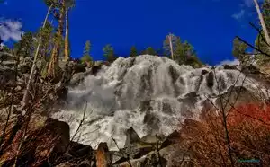


Great Elevation Trail Walk
About a half hour's drive from downtown Scottsdale this place has a nice challenging trail system for you. Lots of uphill trails will take you to the namesake Tom's Thumb and beyond if you are up for it. Lots of trails and lots of foot traffic (at least on the day we went) here. Great desert flora all around. We even saw a rattlesnake. This is a great place to burn off your breakfast and then some. Spend two or three morning hours walking through here and you will be set up for a nice big lunch. There is no entry fee and the parking is also free. There are washrooms at the base of the trails where you park. Enjoy.