


Live Your Best Lives
Turtleback Mountain Reviews
4.7
5 of 33 Best Attractions in Orcas Island


Reviews

Worth the Climb
We took the South Trail and then the West Overlook to Ship's Peak. Didn't realize it was 5 miles each way to Turtleback from the south trail but the views were amazing the whole way through. If you want a more direct hike I highly recommend the North trail. Terrain was steep but trails were wide and easy to travel - also well marked with signs as we made our way. Don't rush to get to the top, relax and take in all the beauty that Orca's has to offer. Once you get to the top it's just as pretty as Mt Constitution but without all the people.

Easy parking, nice hike great views
Was staying nearby and saw how close parking lot was so just started walking. Less than 5 mins into fern grove with "redwoods," I took a bridge over creek and a woodpeckers was pecking away so furiously that I could see the wood chips floating down in the streams of sunlight. Easy hike to top (* mi, total) and fantastic views of Massacre Bay. Lotta fun. Saw a lot of families with younger children hiking up as we were coming down. Definitely worth it.

Perfect hike
The 3ish-mile roundtrip up to Ship Peak and back was beautiful and the trail was well-maintained. It was steep at times, but even at 6 months pregnant I found it quite doable. Views are stunning! Go on a clear day so you can enjoy the view of the islands.

Great Views, Great Hike
Not too crowded, with awesome views. The road was a little hard to find, but other than that, we loved it. I'd go again, for sure.

Hike a magnificent hilltop that dominates Orcas Island
Do you want breathtaking vistas ?The hike up turret back mountain is simply breathtaking...be sure to bring your camera..the views west to the sunset or 360 degrees round give you the full picture of why we who live on Orcas love it.

Orcas Hiking Without The Crowds! Excellent!
The hiking on turtleback mountain was easy to moderate difficulty and offered a variety of hikes and views of the surrounding islands and water. If you are looking for an easy hike, use the south parking, the trailhead leads you traversing through the woods until you meet a well groomed access road/wide trail. It's important at this junction to continue on the groomed wide trail... it provides a gradual ascent without roots and rocks. We met up with a couple in their 70s hiking this portion... it's doable for all ages. If you want a more challenging hike, when you meet the groomed access road look across for a continuing single track trail. This is the hike we took and it was definitely more of a workout with 700 feet elevation gain in less than a mile. This does provide views you would miss if you take the out and back on the access road. It eventually loops back to the access road once you get to the summit.
The north trailhead is also worth a hike. The first two miles follow a fireroad with a pretty good incline and provides an excellent workout. I saw absolutely no one on this hike... except deer, raccoons, rabbits, and birds galore. The north trail can be followed all the way to the south trailhead but once you reach the peak you can make a loop and return to the north trailhead. Towards the summit, there were marshy areas that you would not expect... quite gorgeous however.
Though not as high in elevation as Mount Contitution, the views were still amazing. I included several photos. Highly recommend!
There is a really good chance you will see the largest rabbits you've ever come across. I don't believe there are any predators on the island for them. We noticed fenced in planted trees and park service told us this was to protect them from the rabbits... who tend to eat everything :)

Lovely hiking
The hike from the School House museum to the turtlehead lookout took us 2-1/4 hours. It was about 5 miles. Beautiful, well managed trail. Tons of moss and ferns. The whole first mile was an ascending grade. Lovely view from the lookout.

Can be a tougher hike than it looks. Go counter-clockwise!
We parked at the South trailhead, and hiked up. We did the easiest route, which had some decent elevation change, so if you're not in decent shape you may get a littel workout. Nothing too bad though.
ALERT: Just make sure you stay on the road, and don't jump onto the trail that you will see on your left coming out of the woods. That is meant to be the exit for the loop. If you start that direction you will be facing a rough uphill climb. Stay to the right for a more gradual ascent, and leave the steeper part for the downhill ending.

Overrun in the summer
Once placid and remote is all together too popular. Snotty people with off leash dogs that swiftly approach children. Lots of Yellow jackets. Steep eroded road you hike up from south.

Many Options -
Many options with two major trailheads. From the south - great views toward West Sound and beyond. From the north trailhead - views out to Eastsound and Crow Valley - and further up to Waldron. Hiking all the way to Turtle Head is worth the hike.

Stunning views and great trails!
My husband and I enjoyed a wonderful day of hiking and picture taking as we took the trails up Turtleback Mountain Reserve. Various benches along the way afforded rest spots with amazing views!

The quieter side of Orcas hiking
While Moran State Park has some outstanding hiking trails, it can get pretty busy in the summer. On Turtleback hikes you will only encounter a few other hikers. The south entrance has more great view as you hike, but the north entrance gives you the top view. Take the side spur to Turtlehead for a nice vista to the north.

Challenging parts but beautiful
This was a bit more challenging than the evening stroll in a previous review . There were definitely some climbing spots that were difficult but the view is stunning.

Nice hike on the South Trail
We did the South Trail that is close to Deer Harbor on Wild Rose Lane. It was a very nice hike with great views. We were there during the week on a Friday and saw very few people. We hiked up the main trail and did the loop back down on another trail.

Significant Elevation Changes - But Nice Views
I have to preface this by saying we arrived on Orcas Island after 10 days of hiking high mt trails in the Olympics and Cascades. Those hikes up snow-covered mts to high passes were so spectacular that it was simply hard for us to appreciate these less rewarding (for US anyway) experiences. Having said that, the views from the top of Turtleback of the surrounding islands and mt ranges were certainly impressive and quite lovely. We hiked several trails on Orcas including the hike around Mountain Lake and a hike in Obstruction Pass SP. We also drove up Mt Constitution. Turtleback was our favorite for the views both at the summit and off the trail. But as others have said, it is NOT a stroll. The loop trail starting from the south trailhead required some real elevation increases. Certainly doable for most people but just don't come expecting an easy rolling hike. It was a cool, slightly overcast Thursday morning and the trail was busier than I expected. And finally: a request for the folks who maintain the trails: it sure would be nice for us non-locals if there was a diagram on top of the mt that illustrates what islands and mt ranges we are looking at. ;-)

Happy Hikers
Hikers really get the best pay-off here without crowds or difficult climbs. The panoramic island views here were just as spectacular as Mount Constitution, but we only had to climb 850 feet to get those views. There were a few cars in the parking lot and we crossed paths with two couples. Trails were in great condition. Bring water and food as there are no facilities except a primitive restroom in the parking lot. (No paved or flat trails.)

Great Views/Moderate Grade
Highly enjoyable walk mostly in forest except for spectacular open views;lots of benches to enjoy the views;quite steep but still walkable in areas; only problem was signage quit on us as we attempted to return to parking by using a loop route rather than going back the way we came.

Great views
A moderate hike with great views of the San Juans and territorial of Orcas island. 1.5 miles to the top with an easy elevation grade. It was a good evening stroll for our family

A great hike with lots of diversity
My husband and I took the north trail head entrance. For the first 1/2 hour, it was just an unpaved road that went pretty much straight up. There was a bench half way up, so that helped. Then there was the single track to the Turtleback Viewpoint. It was a very diverse trail with lots of ups and downs. And the view at the top was spectacular!

Stunning Views on Sunny Day
I can usually do a short hike, but I’m a slow hiker age 55 with bunions and this is a very steep hike so I needed the easiest route and a walking stick.
We were trying to use Google navigation to get to the South Trailhead and it led us to a private road, so just ignore Google and drive to Deer Harbor Rd and turn onto Wildrose Lane to reach trailhead.
We went on a Monday in the late morning in August and there was adequate free parking. There is a port-a-potty at the trail head. Take a picture of the trail map with your phone as we had to refer to it several times at various forks in the trail.
We took the Lost Oak trail to Ship Peak. It was a steep hike in a dense forest with lots of birds to observe. I was glad it was shady the whole way up. There is a sign to an overlook before you reach Ship Peak that is a stunning view to the west. We ate lunch in this location. Continue on to reach Ships Peak to view East over the Island.
On the way down we took the West Overlook trail. It’s more exposed to the sun so it looked hard for the elderly people trying to hike up that way. It was a good way to go down as you enjoy more water views. I used a walking stick which was very helpful.
The round trip took almost 2 hours of hiking plus 20 min for lunch at the top. Bring a backpack with water, food, towel to sit on, jacket, visor or sun hat.

Great overlook!
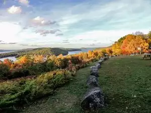
We've only hiked the "south trail" so far. It is a climb, but the woodland trek and eventual views toward the top are worth it. You can see Crow Valley, Mt Constitution, and various bays/harbors of Orcas Island. Also, you can see other islands, the Olympics, various mountains of the Cascades on clear days, and lots of beauty to the east, south, and west. Wonderful place we've visited more than once and a great place to take visitors.

Turtleback Mtn
Hiked up to viewing area overlooking valley from Wild Rose Lane parking area - holds about 8 cars (go early). Nice perspective. It was a very warm day so we didn't go over to the west side.

Excellent hike and view
Just off the ferry, we decided to stretch our legs with a quick hike. Well maintained trails and cool views of the surrounding islands. We parked at the North trail head. 1500' climb in the first couple of miles, so the start is not for the faint of heart. Orcas Knob also called Turtle Head offers a great view. We ended up hiking 9 miles!

Explore both trailheads!
On a recent trip to Orcas Island we took two days to explore both the north and south trailheads. Both were great.
From the north trailhead, we took the North Trail to the North Valley Overlook, Waldron Overlook, and Turtlehead. All 3 overlooks offered great views. The trail between the overlooks is mostly a gravel road, which I understand from our Orcas guidebook was designed to serve as a driveway for luxury homes before the project was ceased and the land preserved instead, with the help of community fundraising. There is a significant ascent at first, but otherwise, the trail itself was so well groomed I wouldn't consider it a "difficult" hike. It does get a little more rooty/rocky beyond Waldron, which is a nice change from the gravel road. The out and back was somewhere close to 6 miles including the spurs to the overlooks.
Our favorite Turtleback trail though was to Ship's Peak from the south trailhead, via the Morning Ridge trail. The trail offered beautiful views for about 80% of the hike. We descended on the Lost Oak trail to see the Garry Oaks. This loop was around 3 miles.

South Trailhead Steep but Rewarding
We only did the South section from the trailhead up through the Lost Oak trail and back to Ships Peak and down. This was opposite of what most people did so we were pretty much alone the whole way. Gorgeous views to be had. We were out on a week day between 10-12 and had very people around until our return...parking lot was full by then.
This is a steep narrow trail up but the trail down appeared to be an old road so was wide but also quite steep. Don't think this would be good when wet/raining.

Lovely Views
By my lights, this is the best hiking on the Island by far. I began my hike at around 9 AM and I think I came across ONLY 4 other hikers in the course of a 3-hour hike (which is great for me. I enjoy the solitude!) One potential caveat: I started my hike at the South Trailhead. Even tho I took the "easy path" (as described by other reviewers), this is a strenuous hike even for folks who are in really good shape. After a long upward stretch, I could feel my heart almost pounding out of my chest (and I'm an avid hiker/power walker).

Beautiful View
We started at the North trail head and hiked to Turtlehead. The first part of the trail was more like fireroad. But then you branch off only a hikers only trail that went through a beautiful mossy forest and the view from Turtlehead outlook was spectacular!

Excellent Islands Views
Looking for something "real" to do on Orcas Island? Park your car, or bike, in the Turtleback Mountain's small parking lot, and prepare for a wonderful hike up the mountain, or hill. It's NOT strenuous, but you can reach elevations that allow for horizon to horizon views of most of the San Juan Islands. Yep. Postcard views each time the well-marked trail rounds a bend, or pokes out between the trees. If you enjoy the fresh smell of spruce and fir, you'll really enjoy this hike. Take along a water bottle, and a trekking pole if you need them. AND your camera! We spent most of a cool winter day on this hike, but you could pace yourself and make it last from 15 minutes to many hours. Plenty of spots to stop and eat your lunch. We've done this hike each time during three winters, so the evergreen smells were at their peak. AND, because of the "cool" weather, we encountered no more than two or three other hikers during the entire day. Highly recommended.

Great Family Hike
Perfect hike with kids - amazing views of mountains and neighboring islands. Some elevation gain, but our boys (5 and 8) did just fine.

Moderately strenuous 2 miles uphill hike. Beautiful views everywhere on a clear day.
I was lucky enough to be on Orcas on a clear day in April and we took in the sights and views and took lots of pictures on this hike. There are other trails off this trail so beware of those. The one we took to the top was an obvious trail, wide with excellent footing like an old dirt road and not muddy at all. There are lots of false summits! Keep going to the top. It's worth the effort.

For true hikers not neighborhood walkers
This is steep! And not for those who just walk the neighborhood at home. We didn’t make it very far before we had to turn around. Don’t be fooled those who don’t normally hike mountains, this is difficult!

Quiet Hike, Great Views
My wife and I did the south trailhead which was a little more steep than we expected, but was quite doable. Really young children may find it a little more difficult though. Since it was so quiet with no one around, we enjoyed all of the deer and rabbits that we saw. And of course, the views from the top were stunning. Positives: quiet, great views, wildlife, and free. Possible negatives: we didn't see any picnic benches, and there is only one port-a-potty at the beginning of the south trailhead.

Worth the effort!
Don't stop at the first lookout! Keep going! You can do it! The reward is worth every step/breath you will take to get there! The parking area has a clean outhouse for use if need be. We took our pup, and did see other dogs on the trail. There are several benches along the route to take a break on. I suggest taking a couple of snacks and some water along with plenty of room on your smartphone for photos!

Easy day hike
We started from the north parking lot and took the left turn at the top loop. It's an easy hike up an old overgrown dirt road till you get to the top, then turns to a hiking path for a little way. This hike can be done with tennis shoes. Bikes and horses are allowed on alternate days, check the web site. We went in May and the salmon berries were ripe for the picking.

Beautiful Vista’s along many wonderful trails
There are two entrances to this mountain preserve. The north entrance takes you to the top of turtle head. The distance is approximately 8 miles round trip. The views on the way up are mostly along forest trails. The view at the top is incredible. The south entrance has several different trails of different difficulties. Several view stops along the way showing different vista. Incredible. Worth the effort to ge there.

Beautiful Views
A friend and I took a hike up the mountain before boarding our ferry on Orcas Island. It was a steep climb, and we saw the largest slug we had ever seen! The views from near the top were well worth the climb.

Beautiful Quiet Walk
Views of the entire San Juans are fantastic on the hike from North to South. Especially the newest stretch to Orcas Knob (Turtlehead). Well worth the time!

Amazing
I have done this hike twice and it does not disappoint. There are two approaches, the one from the east is a longer hike for the more ambitious...You walk up a road for much of the hike, and it is all just lovely with a view at the end that is beautiful!

Best Views on Island
While Mt Constitution gets all the love, the view from Orcas knob (AKA Turtlehead) I think are thebest on the Island. You gotta hike there and while not super hard, it is a bit of up and down, but terrain is solid so not technically difficult at all. Make sure you take the Turtlehead trail to the end, you will be rewarded

Beautiful sunset hike; but tough!
We started at the south trail head with the goal of climbing to Ship Peak and then back down around. Others said this would be an hour. The trails were not marked well so we are not 100% sure we actually made it to Ship Peak after 1.5 hours up. The views were amazing as the sun was going down, but we were still not sure if we were going in the right direction so to be safe we hiked back down the way we came. Entire hike took 2 hours with stops for photos. So give yourself time and plan on some tough, straight up hiking most of the way. It was so green and mossy and it was terrific to be able to bring our dog on the hike. Go to Deer Harbor Inn afterwards for dinner!

We love hiking. It doesn't have to be epic to be great. The hike to turtlehead (or Orcas Knob) was well signed and the newer trail was well maintained. The first half is and old logging road in excellent shape. The trail to orcas knob took us thru woods and came out on an overlook with gorgeous views of the straits and islands.
But so disappointing to come back to the trailhead and find our truck had been vandalized. After going to town and filing a report with the sheriff we headed back to our inn in deer harbor. We stopped at the same trail head just to see it again and found another truck had really been damaged: both front door windows were smashed. We called the sheriff to report it. We just feel awful that such a great little preserved spot is attracting vandals.
Suggestion: clear out the bush between the trailhead and Crow Valley Road. That will remove the visual barrier that vandals rely on. And put up a wildlife camera. With a sign indicating high prowl area and video surveillance.

Up Up and Away
If you have the ability to walk uphill for a very long time, this is a wonderful way to catch some gorgeous overlook views of emerald Orcas Island.

Quiet serene hike.
This review is for the south trailhead. Nice rural hike. Not busy at all. Views of various islands from lookouts. Harbor views, fairly reasonable slope to the top. Lots of grasslands, mixed with trees. Nice quiet hike.

Great overlook
We parked at the north trailhead and hike to the North Valley Overlook, Waldron overlook, and then the Turtlehead overlook. After the first two, I wasn't sure if the last one would be worth the effort out and back. It was, in spades.
It is a little hard to get information about the trails--the pdf on their website seems to be missing elements that should be on the legend. Specifically, the triangles represent key elevation marks, and therefore, likely the best views. (it appears that the best viewpoints might be Turtlehead (1005 ft) and Raven Ridge (1519 ft).

Nice for a couple hrs or all day hikes
Very nice trails that vary in difficulty and are well maintained. Beautiful views that are not overrun by seasonal visitors.

Turtleback Mountain, 1300 ft of elevation in a short time
Viewing this mountain from the road approaching it, gives you a false sense that the hike is gradual. We started at the south end and the climb was on a nicely groomed path, but the elevation comes fast. This is a good workout. 1300 ft approx of elevation gain to the top. The views are worth the effort. Not for the beginner hiker. The parking area at the south end is not well marked. Just look for other parked cars, and you are at the right spot.

Lovely hiking
Amazing hiking on wide trails among trees, moss and ferns. Turtleback mountain has access from two trailheads with small parking areas. It’s not flat, but the scenery is beautiful and there is plenty of shade for the warmer days.

???
This is a mountain??? Please don't go there. At the very most this is a hill, and even that is being generous. But, like everything around here, very pretty!

Great hiking!
We used the North Trail and found it to be very peaceful with very few other hikers. The steady elevation gain makes for some good exercise but nothing too strenuous if you are in reasonable shape. There are some excellent views and beautiful landscapes to enjoy - you won't regret your time hiking on Turtleback Mountain!

Tough uphill but soooo gorgeous!
Thanks to other reviewers we took the Waldron Overlook hike. I am in fair shape and found the uphill climb 'do-able'. It was worth it anyway. Stop along the way to see the other overlooks, especially the valley one. AHH! For the birdwatchers out there be prepared to see and hear a ton of birds! I do recommend you bring water along, we forgot ours and that was a scary mistake!

Our second favorite hike
Been all over Turtleback for the last two years. As two seniors we try to get some good exercise a couple times a week. This is a great place to hike. One disadvantage is that unlike the state park, you are not to leave the established trails nor can one collect mushrooms, berries and nuts on this large property. During mushroom season we prefer Moran and Mountain lake trail specifically. But for some great views the North trail gets you a great view of Crow Valley and a great view of the islands to the north.

Nice hike
We walked up the South trail, and looked over the Crow Valley just short of the overlook proper. But we had an awesome view from where we were. There are a couple of benches at lower levels that look out over the water and the other islands to the South. They make a great little rest area, as you walk both directions. The main trail seems to be an old logging road.
My only complaint would be people leaving dog poop bags at the trail’s edge.

Good but....
Awesome hike but our car was broken into, but nothing was missing as we don't have anything worth stealing but still windows were smashed.

Fantastic hike, incredible views!
We hiked from the south trailhead: Lost Oak/Ships Peak/Morning ridge. It was a nice, steep climb up and forest was gorgeous! The views at the top were incredible!We could sit there all day and enjoy them. Loved the benches at the view points. We were pretty much by ourselves the entire hike and only saw two other people on our way down. Perfect!

Nice Hiking
We went in from the north end. Got as far as Waldron Island Overlook. Hiking on a moderately steep logging/fire road. Saw some interesting birds. We wanred to go out to Turtleback Head but recurrent injury prevailed.

Great winter hike
Have hiked from the south trailhead and the north, both in February. Great for spotting eagles and for views of the other islands. Make sure you have waterproof hiking gear and rain gear if you go in the winter. Free parking and no Discover Pass required.

Beautiful vistas
We did the steep hike up lost oak trail to ship point. Took about an hour. Loved it. Not crowded. Nice day hike to take in the morning and start the day off right on your orcas vacation.

Hike from South Parking Lot
We had read that the hikes from the south parking lot were more scenic, so we chose that starting point. We did the Morning Ridge Trail to Ship Peak, then down Lost Oak Trail. Probably took a couple of hours with good elevations.

Great for an moderate to easy hike
Lovely secluded walk with multiple routes and views. The hike gets your heart rate up but it is not a super difficult trail. I brought my hiking poles which made the steeper parts much easier. All the moss, trees and plants were beautiful.

Steep hike but stunning views
We did the north trail entrance. This hike is strenuous but the path is wide. I believe its about a 900 foot climb. It is actually a road in the preserve but closed to the public. I feel this hike is different from a lot of western WA hikes in that it seems to have more of a grassy meadow feel to it. There are two outlooks.

See Moran, but don't miss this!
We LOVED Turtleback. The views you get at the top are very different than at Moran State Park (also a must see!). It is a good workout to the top--bring lunch and enjoy the views to the west.

Fun but steep hike with amazing view
We hiked up the south trail to Turtleback Mountain on Orcas in August 2017. It was a beautiful, clear and relatively cool day. The trail is very well maintained, but fairly steep. It averaged around a 9-10% grade, and certainly steeper in spots. Ultimately, it was well worth it due to the spectacular views of the San Juan Islands, the Olympic Peninsula, Vancouver Island and more. If you can reserve 2-3 hours and it is a nice day, I recommend this without reservation. I have been going to Orcas Island at least yearly for about 20 years, and this was my first time hiking this route. I will definitely consider doing it again.

Great views on a beautiful day
We hiked from the south parking lot to the West Overlook and Ship Peak. The rewards are good for this relatively short hike. There is some elevation gain as Ship Peak reaches 931 ft. We had planned to do the loop including the Lost Oak Trail, but we never found it. No big deal as the trails are mostly out in the open and it's easy to navigate.

Second best views in the San Juan Islands!
This place is second only to Eagle Cliff, on Cypress Island, for incredible views of the archipelago. It is a nice walk, at any season.

A view worth the hike
After a continuous climb one is rewarded with a magnificent view of the San Juan Islands. Plan on climbing for about 1.6 miles and take water if it is a warm day.

Good scenery!
We took the south trail and took the Lost Oak trail to Ship Peak. Was rather hard for us seniors, but we made the loop in 3 hours.

Tough but worth it.
We did this hike on a very misty, drizzly morning. It's a beautiful hike with what I'm sure are stunning views on a clear day. Everything was shrouded in mist/ fog on the day we were there and we wouldn't have had it any other way. Tough hike though, so be ready!
Popular Attraction Reviews


Steep but worth it!
The Visitors' Bureau in Eastsound gave us a good map, and the drive to Wild Rose Lane is nicely rural, past the Coffelt Farm stand. The older man at the Bureau said it took him "half an hour to get up to Ship Peak, while working up a light sweat." He must have been an Ironman athlete, because we took closer to an hour - admittedly, the blackberries and photography slowed us down, but still... From the South trailhead it is easy to choose the Lost Oak trail (steeper but shorter) or the main road. We walked up the road and down on Lost Oak. Raptors, fantastic views, and scenic benches. Met Nick, one of the many trail volunteers, beavering away on improving the path on his Saturday. Thank you, trail workers! What a great gift to future hikers.