


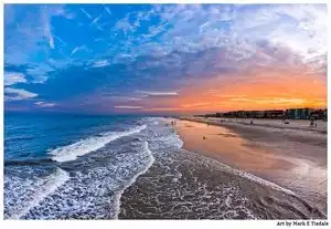
Live Your Best Lives
Whitney Pockets Reviews
4.3
4 of 16 Best Attractions in Mesquite


Reviews

weekend get away
It was a great way to spend a afternoon. Beautiful area very fun to walk through. Would do it again. We were here at the end of Jan so the temp was perfect.

Interesting but difficult road.
The desert and formations are interesting but if you don't have a truck or SUV the road is a challenge. The paved road only lasts a few minutes and then becomes a mess. It was a paved road 50 years ago but has deteriorated in the sun so badly it is only a rough, bumpy gravel road with the occasional spot of pavement. It seems to be used by people with ATV's going to do some off road adventure. Not worth the effort because the area around Mesquite is quite stunning.

Truly fantastic geology plus petroglyps
Half-day visit with local friends. Glad we'd stopped at the Friends of Gold Butte National Monument office in Mesquite ahead of time for a map ($10) and local intel. CCC dam at the Pocket is quirky. Rock scrambling near the parking area on Black Butte Road became a treasure hunt for petroglyphs. Did some further exploring, but these were the highlights. Would return again, perhaps to camp.

Susan fromidaho
We loved it up there. The desert is a whole new world and I have fell in love with it!! There was alot if hiking and lovely cactus in bloom. There is great parking and fun getting there.

A geographically beautiful location
At the end of the "new" Bold Butte road, the red rocks of Whitney Pockets arise from the desert, waiting to be climbed.. This area is primitive, there is a fairly large dry campsite. ORF trail heads are near.

Unable to locate this
Wonder if this place is still available…
Was not able to locate it.
Drove around a lot where GPS said it should be; however, we missed finding it..

Isolated and remote
Fascinating geology in a very remote area. True wilderness!!! Although we saw another car (parked), we saw nobody.
The only downside was the road getting there.

Fun and beautiful place for an outdoor picnic
The roads are much better than the travel advisories make them out to be. Granted, they are a little bumpy, but they are safe. The road to Whitney Pocket starts from exit 112 of I-15, Riverside, just before Mesquite to the north of Vegas. As you travel Gold Butte road, you pass by an entrance to the Bundy ranch. The Bundy's, Cliven and Ammon are the ones a few years ago that had a standoff with the US Government, when they refused to pay fees for using government land to graze their cattle. We suggest that you read about this on the internet.
Whitney Pocket is a great place for a sit-on-the-rocks picnic. If it is windy, go to the leeward side as we did. We were hoping to see some ground squirrels scurrying around from the many holes in the area. Sadly, I found a small pile of empty .22 bullet cartridges near the holes. Apparently, someone was having fun killing all of them. Perhaps you can catch them and report them. Not that Nevada will do anything about it. Aside from all this, the outcroppings or exposures are beautiful. If you are an armature geologist or just curious about the millions of years of planet earth's formation, this is a great and beautiful example. One of the better parts is that there are no visitor centers, trams or crowds. You may not even see another human. We only saw one in a pick-up. Bring food, if you want, but definitely bring water!

Wrong address
Went to this address and it took me to the top of a bridge. Nothing around this area. Look more into where the actual location is.

Great location to Visit
Fun location to visit if you have never been there. Remote location and the scenery is nice, especially in spring when the desert flowers are blooming.

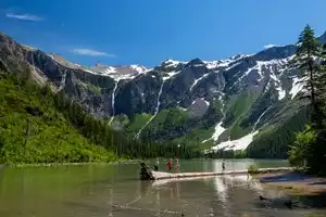
Remote and beautiful area to explore
The "paved" road getting there for the 20 miles beyond the Virgin River is in poor condition, but passable if you take your time. Once there, park and explore around the rock formations and history (a small CCC-built dam and storage area). Interesting rock colors and strange rock forms (narrow pointed dark layers protruding from near white rocks). Joshua Trees and some wildflowers (depending on rain and time of year) add to the scene. There is no water and no restrooms there. Probably much too hot in the summer.

Fantastic views
Great area to hike and explore. The rock formations were beautiful. You could see forever when you looked back across the valley. Take a picnic and enjoy the views.

Excellent April flowers
We went in and out of all possible intersections and around 4-5-6 large rock formations looking for the falling man. We had the exact directions back home on the table. We are going back this month to try again. Flowers were good. Signage was poor. Several families of campers seemed to be enjoying themselves.
No shade, none, byoshade, water, food and your own maps.

Place Looks Like The Backdrop For Deathwatch (the book)!
This has to be the coolest place to visit in Mesquite! Climbing, hiking, exploring, and sight-seeing are what you can do here. There were people camping and had their mini Gators/Razors wheelin' all over the place. I drove the entire way in my Honda minivan -the road is there yet not there at times. I would have driven a little faster had I been in a SUV -we were following our friends in their Suburban and they left us in the dust -literally. Beautiful backdrop for pictures!! I would visit again -for sure!

Fascinating geological formations
This entire area is remarkable, with petroglyphs, so much color in the rocks--makes you wonder how all this was formed. Great day trip or location for a picnic.

Wonderful outdoor hiking and scenery
Interesting old dam built during the CCC era hidden in the rocks. Gives another perspective on people actually living in the desert.

Nice Place
Whitney Pocket is located along Gold Butte Road that starts at Mesquite, NV. The road is paved only to Whitney Pocket so you do not need an SUV and if you want to drive further the road becomes gravel.

Beautiful place!
Rough ride in our camper, but worth every mile of it! Stunning views every direction. Go and enjoy! You won’t regret one second of this visit.

Beautiful, stark scenery
Getting here can be interesting: road is narrow and, in places, a bit rough. But the rock when you get there is outstanding! Brilliantly colored, weirdly eroded, and bonus! hieroglyphs. Dry camping is allowed, as is off-road vehicles.

Gorgeous desert landscape
We've both hiked and toured this area on ATV. Very beautiful. Remote feel but not really that far from 'civilization'. The road in from Bunkerville is a little rough but very passable by most any car/truck. There are a couple parking/ATV staging/camping areas but we certainly didn't feel crowded. Amazing area for anyone who is keen about photography. No services so be prepared with plenty of water.

Beautiful and colorful rock formations
Follow Gold Butte Rd. From Bunkerville/Mesquite area until the pavement ends and the road becomes dirt/loose gravel. Turn left (there is a sign) and there are a number of rock formations. These are filled with indents, some windows, and fins. There are pull outs at a few of the formations so you can park and explore.We were at Gold Butte NM for most of a day and saw no one else. There are no facilities and very few signs. Bring water. Do not attempt side roads unless you have an off-road vehicle. Even at the end of September it is still quite hot.

Be Careful!
This adventure should be approached with an older 4x4. We have a 2018 full size suv , i didn't go quite all the way. The road is broken pavement the entire way, 15 mph average. Anything faster than that will shake your vehicle to death. There is no danger of getting stuck, however you will be heading to a local dealership for a complete inspection. We drove 90% of the way before i started seeing dollar signs.

Beauty in Solitude
We drove a roughly paved and gravel road for miles from Bunkerville to Whitney Pockets, watching the changes in vegetation and rock formations. There were a few families and couples enjoying the scenery. By the dam, there are rough cement steps up to where children were exploring one of the rock formations. The view and solitude were humbling! Next time, we will bring a lunch and go all the way to Gold Butte.

amazing place
astounding place in the desert . great hiking and the sights are fabulous. climbing inside the pockets and feeling the wind was amazing

UTVing in Whitney Pockets Area
Great area. Clean and open. While you may see people at places like "Falling Man" (Nearby) and "Little Finland" (also nearby), plenty of riding areas. Stop by any BLM office and pick up some free maps. They show the trails and routes. Most have route #'s so you will know where you are at. There is some cell service out of Mesquite. Mesquite is a good place to base camp. UTV's are legal to drive except on a few streets (Pioneer from Oasis to Sandhill. No Sandhill at all. No Mesquite Blvd at all. No Falcon Ridge from Pioneer to Mesquite Blvd. Make sure you wear your helmets in town!!!

ATV ride
We rode our Raz'r out to Whitney pockets the first day. It was an easy ride and the people we met on our ride were friendly. The area is filled with history,

Interesting Area
Rode out here looking for 21 Goats petroglyphs and loved the rock formations. This is best traveled in high clearance vehicle. Be aware there is not any cell service in this area.

Awesome day trip
Worth the drive for an interesting afternoon. Nice area to have a picnic. Fun to explore the rock formations.

Nice day trip
This area is full of history. You can find fossils, petroglyphs, arrowhead flakes and works of the CCC from the 1920's. A must see for anyone in this area. Plenty of places to park in the dirt and enjoy the desert responsibly. Lots of interesting rock formations and plant life.

End of the Paved Road in Gold Butte
This is a favorite of soft adventure enthusiasts because it is safely accessible by regular vehicle. The paved portion of Gold Butte Road ends just at this area, about 30 miles from Mesquite. Take lots of water and a camera. Look for a dam built by the CCC and rock art and other signs of early inhabitants of the area. NO SERVICES here, so
be sure to let somebody know where you are going and when you plan to return in case of car
trouble. Beautiful wildflowers in area during early spring. A magic spot.

Cactus and joshua trees!!!!
Just go there! Stay on the road and respect the desert in all it's glory. Plenty of cactus and joshua trees to see. Birds and other creatures as well. If you can make it in the spring the joshua trees blooming are a special thing to see.

Tortured topography!
This is but one of many interesting spots within the Gold Butte National Monument 22 miles south of Riverside, Nevada. The road is paved but very worn and can be traveled by any vehicle. Wonderful rock formations and open to primitive camping for the sunrise/sunset views!

See some fun Petroglyphs and experience the life of a CCC worker in 1930's
This is one of the highlights of the Gold Buttes National Recreation area that isn't too far off the road. Close to the Whitney pockets, the Cistern, and the Falling Man petroglyphs, and the road is sort-of paved. Not as bad as some dirt roads, but still rough. I took my jeep, so no problem.

Beautiful views
Absolutely beautiful views easy driving and spectacular walking hikes easy and hard. Not very wheelchair friendly but great drive threw views.

Old asphalt causes the only access road to be rougher than some dirt roads, keeping the area quiet and not busy.
You can see the red sandstone of Whitney Pockets in the distance from across Lake Mead. Just look below and to the right of Virgin Peak when you are traveling toward the east access of Valley of Fire, one of Nevada's most popular state parks. Past Whitney Pockets are dirt roads leading far into Arizona, providing access to the extremely remote east shores of Lake Mead and mining claims.

Nice little area, but nothing to write home about
Set out to do something in nature. This is in middle of nowhere and though has some nice craved out structures, in end thought long journey to see rock pockets that aren’t the kind that set world on fire. Granted it was 106 degrees and had to stop and help old coup,e with children change flat. We were the only 2 cars back there thst day and lucky they were on edge of cell reception. After over hours with them in sun fixing car might of changed my perception. About 8 miles from site started losing internet data connection. This is really in middle of nowhere in unpatrolled area. Roads not as bad as some say. Had a Jeep Cherokee and was fine. Just long wat 31.5 miles from Casablanca Casino. 19 miles on unmaintained road. Just a long way to see some average rock formations. Bring lots of water and some food. This is ilosated spot

Array of different colored and shaped sandstone.
Cannot be described, there is an oasis half way from Riverside on Gold Butte road with the largest palm trees I've ever seen. There is a dam built by the Conservation corp back in the 1092's. fun place to hike and take pictures. If you are adventitious Devils Throat is just 10 away.

Whitney Pockets
Definitely should have a 4x4 for this drive. The road is pretty rough in some spots. Saw some campers in a remote spot. There are a couple of porta potties in the area which was nice.

Good place to let your kids run.
great place for camping out or just climbing around or picture taking. Good all around place if you have kids. Road to it is so, so it is mostly paved but watch for the pot holes.

Nice area to hike and explore
Beautiful area with a lot of hiking and interesting rock formations.
Very educational regarding the people that lived there long ago.
Popular Attraction Reviews


Neat Place to Camp
Getting to Whitney Pockets takes some patience as the road is not in the best of condition. The pavement is badly broken up in places. However, once there, it offers spectacular scenery to explore. Camping is primitive, however, so be prepared. There are lots of nearby places to visit and we found many locations where there were some excellent examples of early-man petroglyphs. The red-rock formations were very impressive. It's a colorful area to explore.