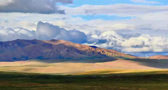
Tanggula Pass

Tanggula Pass is the boundary between Qinghai and Tibet and the highest point on the Qinghai-Tibet Highway. It is known as the "snow warehouse" because of the constant snow and wind.
There are monuments and signposts at the mountain pass. It is the only way to enter Tibet along the Qinghai-Tibet Highway and is the source of the Yangtze River.
The uninhabited area of Hoh Xil at the foot of the Tanggula Mountains is a peaceful pasture for endangered wild animals such as the Tibetan antelope.
User Reviews

"Tanggula" means "mountain on the plateau" in Tibetan. It is known as the "snow warehouse" because of the wind and snow all year round. Tanggula Mountain is the northern gate of Tibet. After passing here, there will be a gate-shaped building with "Northern Gate of Tibet" written on it. After leaving the northern gate, the navigation prompts us to arrive in Qinghai Province.


There is only one stone tablet here, the wind is howling, and the ultraviolet rays are very strong. The toilet is a great wonder, don't go to see it easily, but you have to understand that it is very difficult to clean the toilet in such a place.


"Tanggula" means "mountain on the plateau" in Tibetan.
The main peak of Tanggula Mountain, Geladandong, is over 6,000 meters above sea level and is the source of the Yangtze River. At its foot is the Hoh Xil No Man's Land.
The Tanggula Mountains are the dividing line between Qinghai and Tibet, and are also the source of the Yangtze River.
There is a monument at the Tanggula Pass, which is a sculpture of road builders, and there is also a signpost.
After crossing the Tanggula Mountains, you will enter Qinghai.


It was so beautiful. The view when we looked back amazed us.


The altitude is so high that people and cars can walk. You will feel so cold after getting off the car for a minute. The wind is so strong and the temperature is very low under the sun.


The experience at Tanggula Pass was thrilling, like being on the set of a horror disaster movie.


The Tanggula Pass is very beautiful in the snow. There is also a chance to see Tibetan antelopes nearby.


It was so beautiful that it was breathtaking. Although I was worried about the car all the way, I was still very excited and kept taking pictures.


The highest point reached by the Qinghai-Tibet Railway is also the place where altitude sickness is most likely to occur.


The mysterious Tanggula Mountain is something that many people are afraid to visit. It is so beautiful that it is breathtaking. The fear also comes from its mystery. Many people go in to see what it is really like.


The main peak of Tanggula Mountain is not as spectacular as imagined. You can see it from the observation deck.


At 9:45 am, we arrived at the Tanggula Pass at an altitude of 5,231 meters. This is the highest point on our entire journey from Sichuan to Qinghai. Here you will be impressed by the road you have walked and be proud of your courage; here you need to sit down and sigh about life and imagine the future; at this time, you will suddenly find that those things that have been bothering you are actually nothing.

There is a stone statue of a soldier at the Tanggula Pass. This group of statues is not big and very simple, not high but very vivid. It was built to commemorate the PLA soldiers who sacrificed their young lives to build the Qinghai-Tibet Highway.


This 5200-meter-high altitude is not a lie. The feeling of walking a few steps after getting off the car is similar to that of the Everest Base Camp. It feels like walking on cotton. Don't walk fast, don't talk loudly, and move slowly. I really want to shout a few times, but I'm afraid of altitude sickness...


The mountain pass at an altitude of 5,231 meters is covered with snow all year round, and even the roads in summer often encounter windy and snowy days. At that time, the temperature in Hangzhou was nearly 40 degrees Celsius and I was in the snow below zero.


It’s not as spectacular as I imagined, probably because the starting point is too high.


Because of the wind and snow all year round, it is known as the "wind and snow warehouse". It is also the dividing line between Qinghai and Tibet, with an altitude of more than 5,000 meters. As the altitude increases, oxygen will begin to be released on the train. Sometimes it is windy and snowy, and sometimes the sun suddenly appears. We look and look in surprise, immersed in such scenery, as if we only have the IQ of elementary school students, and we keep sighing that nature is really amazing.


It was snowing and freezing, I watched the sunrise and encountered a huge traffic jam


Not long after passing the Tanggula military station, we arrived at the Tanggula Pass at an altitude of 5231 meters. This pass is the highest pass we crossed during this trip to Tibet, higher than the base camp of Mount Everest. But it is surprisingly low-key. There is only a stone with the words "Bright Road" and a road sign with the words "Tanggula Pass". There is nothing else. This stone tablet does not talk about the Tanggula Mountain, but introduces how the State Grid crossed the Qinghai-Tibet Plateau and how awesome it is. In short, if you drive faster, you will not notice that this is the famous Tanggula Pass.


I still had some altitude sickness, and after walking for a while, it was very cold. After all, it is an iconic landmark, and I have been there before.


Tanggula Pass, the highway is 5231 meters above sea level, and the railway is 5072 meters above sea level. It is the natural boundary between Qinghai and Tibet, with a wide view and a long-distance vision. This area is a frozen land, and the moisture in the soil layer is frozen all year round. The weather at the pass is extremely unstable. Even in summer, the road is often blocked by heavy snow, and hail, frost and snow are more common. The oxygen content in the air here is only 60% of that at sea level, so most passengers passing through Tanggula Pass will have obvious high altitude reactions.


Walking into the Qinghai-Tibet line, passing through Tanggula Mountain, Hoh Xil, herds of Tibetan antelopes, people and nature


This is my first time writing a travelogue. I don’t know how to do it. I ended up writing Chengdu as my destination. I don’t know how to change it.


Let's talk about taking a train. Currently, all trains going to Lhasa in China have to pass through Xining, so there will be no serious ticket rush when buying train tickets from Xining to Lhasa. Oxygen is provided on the train, so it is suitable for people who are afraid of altitude sickness. After five hours of passing through Golmud Station, you will enter Hoh Xil. You can take photos as much as you want in the next half day, and the scenery outside the window is full of beautiful scenery. Tanggula Station is 5,000+ meters above sea level and is the highest railway station in the world. The original platform was designed only for sightseeing and meeting. There is no exit in the station hall. Inside is the Qinghai-Tibet Railway Memorial Hall, but so far no train has stopped at Tanggula Station to let passengers get off for sightseeing.


The only way from Tibet to Qinghai is very beautiful. It snowed the day before. It was very shocking to see the continuous hills covered with snow in summer. However, there are no large towns to stay in during the 800-kilometer journey from Nagqu to Golmud. It is still very tiring to walk in one day, so I didn't stop much along the way.


When you take the train from Shanghai to Tibet, you can see it clearly at noon. It is very beautiful! "Tanggula" means "mountain on the plateau" in Tibetan. Because of the wind and snow all year round, it is known as the "snow warehouse". Tanggula is the dividing line between Qinghai and Tibet. It is 5,231 meters above sea level. There are monuments and signposts at the pass. It is the only way to enter Tibet along the Qinghai-Tibet Highway and it is the source of the Yangtze River. This is the highest highway in the world.


Beautiful, beautiful, beautiful, bright sky road, graffiti.


The eyes are in heaven, the body is in hell, the scenery is stunning but you need a good body to go there


The highest point on the Qinghai-Tibet Highway. Please be careful to move slowly when you get off the bus to take photos.


I drove along the Qinghai-Tibet line. At the end of September, the border guards remained unmoved in the heavy snow. It was really admirable. It was also here that I connected to the 4G network for the first time in two months. In memory of this


Tanggula is the boundary between Qinghai and Tibet, with an altitude of 5,231 meters. There are monuments and signposts at the pass. It is the only way to enter Tibet along the Qinghai-Tibet Highway and the source of the Yangtze River. This is the highest highway in the world. Because of the wind and snow all year round, it is known as the "wind and snow warehouse". So when you get off the bus, you should pay attention to two points: one is to add clothes to prevent colds, and the other is that the altitude is high, so don't run after getting off the bus, walk slowly to prevent altitude sickness.


It is on the Qinghai-Tibet Highway 109, which seems to be the border between Tibet and Qinghai. It is the highest place on our way. There are snow-capped mountains in the distance. It is not cold on sunny days. After we passed it, it started to rain and it was a bit cold.


"Tanggula" means "mountain on the plateau" in Tibetan. It is known as the "snow warehouse" because of the wind and snow all year round. Tanggula is the dividing line between Qinghai and Tibet, with an altitude of 5,231 meters. There are monuments and signposts at the pass. It is the only way to enter Tibet along the Qinghai-Tibet Highway and is the source of the Yangtze River. This is the highest highway in the world.


In the beautiful twilight we headed towards the Tanggula Mountains.
I kept praying silently in my heart that it would get darker later, darker later,
Crossing the Tanggula in the dark would slow us down.
However, the night fell irresistibly.
At 20:41 in the evening, we arrived at the Tanggula Pass amidst the bumpy ride.
The mountain pass was in chaos and had turned into a construction site. We gave up the idea of letting the dog get out of the car to take pictures, and just took two random pictures in the car and went down the mountain.

Tanggula is the boundary between Qinghai and Tibet, with an altitude of 5,231 meters. There are monuments and signposts at the mountain pass. It is the only way to enter Tibet along the Qinghai-Tibet Highway and is the source of the Yangtze River. This is the highest highway in the world. This iconic place brings a sense of pride. Looking at the Tanggula Mountains from a distance, it is not steep, and even a little gentle. A row of snow-capped mountains extend in long strips, like giants. In such a place where humans cannot survive for a long time, there are not many wild animals, which shows the serious damage to China's wild environment before. I have the honor to see three legendary Tibetan antelopes, which is a blessing. I hope China can have a peaceful paradise for wild animals


Tanggula Pass is the boundary between Qinghai and Tibet and the highest point on the Qinghai-Tibet Highway. It is known as the "snow warehouse" because of the constant snow and wind.
There are monuments and signposts at the mountain pass. It is the only way to enter Tibet along the Qinghai-Tibet Highway and is the source of the Yangtze River.


Very good and meaningful scenic spot along the way. Be careful of altitude sickness at an altitude of 5,200 meters.


The highest altitude on the Qinghai-Tibet line is here. It is worth stopping here to take pictures, and then you can get some milk tea from the shed next to it and drink it on the way.


I remember going to Tibet and crossing the Tanggula Pass a few years ago. The potato chips were all burst. I didn’t report it this time, but I felt that the potato chips could float.


The Tanggula Pass has the highest altitude on the entire Qinghai-Tibet Highway, so if you have just arrived at the plateau, you should move as slowly as possible. The scenery at the pass is very good, and it is the most beautiful pass I have seen on this trip. The mountains in the distance, coupled with the white snow, are intoxicating.


The Tanggula Pass, which we passed by when we took the Qinghai-Tibet Railway, is said to be the highest railway station in the world.


The highest point on the Qinghai-Tibet Plateau, the sky seems to be lower, and white clouds are on the horizon. There are a few bright gems scattered around! The top of the mountain is covered with snow all year round. After driving all the way from the Qinghai-Tibet Plateau to Tanggula Pass, you should have adapted to the altitude of the plateau, and generally you will not have too obvious altitude sickness. There are no public service facilities at Tanggula Pass. If you cannot adapt to the altitude, it is recommended to bring some glucose injections and oxygen for use.


At an altitude of over 4,000 meters, what public services are needed? I went there in 2009, and there were none then. I don't know what the situation is now.


At about 11:30, the train began to cross the Tanggula Pass, which is more than 5,000 meters above sea level (Tanggula Mountain Station is known as the highest altitude railway station, and the altitude is shown at 4,809 when passing through). When crossing the Tanggula Pass, the train climbs up the slope and increases in altitude. It moves slowly and has a large curve. At the bend, the rear carriage can take pictures of the train's trajectory.
It's a pity that the carriage is closed and the windows cannot be opened, otherwise this section can definitely be photographed as the most beautiful plateau train. I took the photo through the glass, the sun is strong and the reflection is bright, the effect is not good, and it is very blurry...


Physical hell, spiritual heaven, you have to go through this to know

My heart really beats faster when I pass by...


Very nice and beautiful, all kinds of shots and all kinds of concave shapes


It is majestic and stunning, but vehicles stopping to take pictures often cause traffic jams.

The visual sense of a magical blockbuster, a really beautiful place


When we went there, it was probably a warmer time of the year. There was snow on the top of the mountain, a large grassland, and on the way back we saw cattle and sheep. This is the dividing point between Tibet and Qinghai on the Qinghai-Tibet line. It is magnificent. But the toilets here are really dirty.


The second largest city in Qinghai, a wild western movie.


When I took the train, the oxygen supply in the carriage was increased, so most people had no problem. Anyway, I stood up to take pictures and also took pictures of the oxygen content meter. Nowadays, the trains basically do not stop.

While traveling at Tanggula Pass at night, it suddenly started snowing heavily and the temperature outside the car was 1 degree Celsius.


I rode there in June. It was snowing, but the temperature was not low.


"Tanggula" means "mountain on the plateau" in Tibetan. It is known as the "snow warehouse" because of the wind and snow all year round. Tanggula is the dividing line between Qinghai and Tibet, with an altitude of 5,231 meters. There are monuments and signposts at the pass. It is the only way to enter Tibet along the Qinghai-Tibet Highway and is the source of the Yangtze River. This is the highest highway in the world.


The scenery of the Qinghai-Tibet Plateau is charming. Due to the high altitude, large areas of mountains are covered with grass, and the mountains without grass are covered with red and yellow soil, which is very dazzling in the sun. There are no shrubs or trees here, but rolling mountains, snow-capped mountains and lakes scattered all over the place. When driving, some large and small lakes will flash on both sides of the road from time to time. In the autumn season, the withered yellow grass, red soil, blue sky and white clouds make the colors in your eyes appear colorful and brilliant.


It is 5,231 meters above sea level, the highest point on the Qinghai-Tibet Highway. It was still snowing heavily when I went there in June!


The blue sky, the white clouds, the snow-capped mountains standing on the alpine grasslands, a very magnificent landscape


The Qinghai-Tibet Highway must pass through. There will be altitude sickness. The altitude is relatively high and it is also very cold. The snow-capped mountains in the distance are very beautiful.


"Tanggula" means "mountain on the plateau" in Tibetan. It is known as the "snow warehouse" because of the wind and snow all year round. Tanggula is the dividing line between Qinghai and Tibet. It is 5,231 meters above sea level. There are monuments and signposts at the pass. It is the only way to enter Tibet along the Qinghai-Tibet Highway and is the source of the Yangtze River.


The most amazing attraction along the Qinghai-Tibet Highway is the Tanggula Mountain, which is the highest place we passed. When we arrived at the Tanggula Mountain, the clouds were still very thick, but gradually the clouds gradually dispersed, and the Tanggula Mountain showed its most brilliant appearance. The snow-capped mountains were shining under the blue sky, and the stripes on the mountain body, like zebra crossings, were colorful under the sunlight. The vastness of the world and the magnificent mountains, the scene at this time is beyond words. It makes people linger.


Tanggula Pass, the border between Tibet and Qinghai, is more than 5,000 meters above sea level and is a world covered in silver.


We have arrived at the Tanggula Pass! It is really beautiful! Looking at the photos now, I always feel that the photos cannot show its majesty. That scene is really shocking!


Although the altitude is very high, you don't need thick clothes in the summer. A long-sleeved shirt, a long-sleeved T-shirt and a windbreaker are enough for the entire trip. Short sleeves are not necessary.


Tanggula Mountain, the bright road to heaven, the monument is erected at an altitude of 5231 meters. The scenery is endless, the vastness of nature is boundless, and the oxygen at an altitude of 5231 meters is thin, but I still can't suppress the excitement of wanting to jump up.

Passing through Nyainqentanglha Pass. In ancient Tibetan mythology, Nyainqentanglha Mountain and Namtso are not only the most eye-catching sacred mountains and lakes in Tibet, but also lovers and couples who depend on each other for life and death. Nyainqentanglha Mountain looks more handsome and tall with the backdrop of Namtso.


When we passed the Tanggula Pass, the highest mountain pass in altitude, we had a terrible case of altitude sickness and had to breathe in oxygen.


There are many accidents at the Tanggula Pass. Many drivers suffer from altitude sickness without warning and die while driving... Later, this was confirmed by JC. This happens every month, so crossing the Tanggula Pass is a milestone on the Qinghai-Tibet Highway.


The Tanggula Pass has the highest altitude, the worst environment and the most complex geological conditions. The altitude of more than 5,000 meters causes severe hypoxia here, and the oxygen content in the air is only half of that in the plains.
Looking down from the bottom of the mountain, I saw such a spectacular view. I grabbed my SLR camera in excitement, but when I stood still on the ground, I suddenly felt dizzy.


Tanggula Mountain is a famous mountain in Tibet, also known as Tangla Mountain or Tangla Ridge, which means "mountain on the plateau" in Tibetan. It is also a famous mountain god in Tibet.


The altitude sickness during the Tanggula crossing was so severe that I vomited everything I ate and even water. The altitude sickness medicine I brought was useless and I had to breathe oxygen the whole time.


At the Tanggula Pass at 5231m, the air is thin and you need to breathe carefully. At this time, we refused to take oxygen because we could bear it.
Beautiful Tanggula Mountain, everything is worth it!!!


There are still people working on the road late at night with lanterns on. I sincerely pay tribute to these road workers living on the plateau. They dedicate their efforts in such a harsh environment, especially at night. Thank you.


Is it true that there is snow all year round in Tanggula Mountains?


At about 12 noon, we arrived at Tanggula Pass, 5231 meters above sea level.
We have reached the highest point of the Qinghai-Tibet Highway! This is also the highest point of this trip!
Tanggula means "mountain on the plateau" in Tibetan and "high mountain that eagles cannot fly over" in Mongolian.
Due to the continuous snowstorms throughout the year, it is known as the "Snow Warehouse".
Tanggula is the boundary between Qinghai and Tibet. There are monuments and landmarks at the pass.
It is the only way to enter Tibet along the Qinghai-Tibet Highway and is the source of the Yangtze River.
The oxygen content in the air here is only 60% of that at sea level.
Therefore, most tourists passing through Tanggula Pass will have obvious high altitude reaction.
[Qinghai-Tibet Highway] is the highest highway in the world (the railway is only 5072 meters above sea level)
Don’t underestimate the 160-meter difference. The higher you go, the more unbearable the “altitude sickness” will be.
Don’t think you can get carried away just because you have stood at an altitude of 5231m for the first time.
Don't think you have conquered altitude sickness and get carried away.
I got out of the car, and stepped slowly, as if I was afraid of stepping on an ant.
The body dare not stretch or sway too much
Of course, all this is a little faster than the slow motion in the movie
Carrying a camera or a mobile phone, the purpose is to take a few photos, check in and leave.
I don’t want to suffer from any adverse “consequences” caused by “altitude sickness” due to excessive excitement.
In fact, the imagined difficulties are often caused by one’s own psychology.
Those who look ahead and behind will never leave their homes