"Detailed Guide to the Three South American Countries" To understand this planet, go to the end of the world for a romantic carnival
Preface
After two years of living in South America, I deeply feel that this is a place favored by God and an authentic place untouched by the world. There are always unexpected treasures to be discovered here. The famous poet Pablo Neruda once said: "If you have not been here, you will not understand this planet."
This is indeed the ultimate destination for many in-depth travelers. It is the destination farthest from China and has the farthest route from China. If you pass through the center of the earth from China to the other end, you will reach the southern tip of South America.
The difficulty of obtaining a visa and the high cost of entry are reasons countless travelers are determined to conquer this region. Precisely because it's so difficult to reach, everything here is sure to leave you with nothing to regret: the literal end of the world? Do you love the desert stars and glaciers that resemble the surface of Mars? Do you hear the most intoxicating love words spoken by the sea? The magical realism of South America is filled with more than you can imagine.
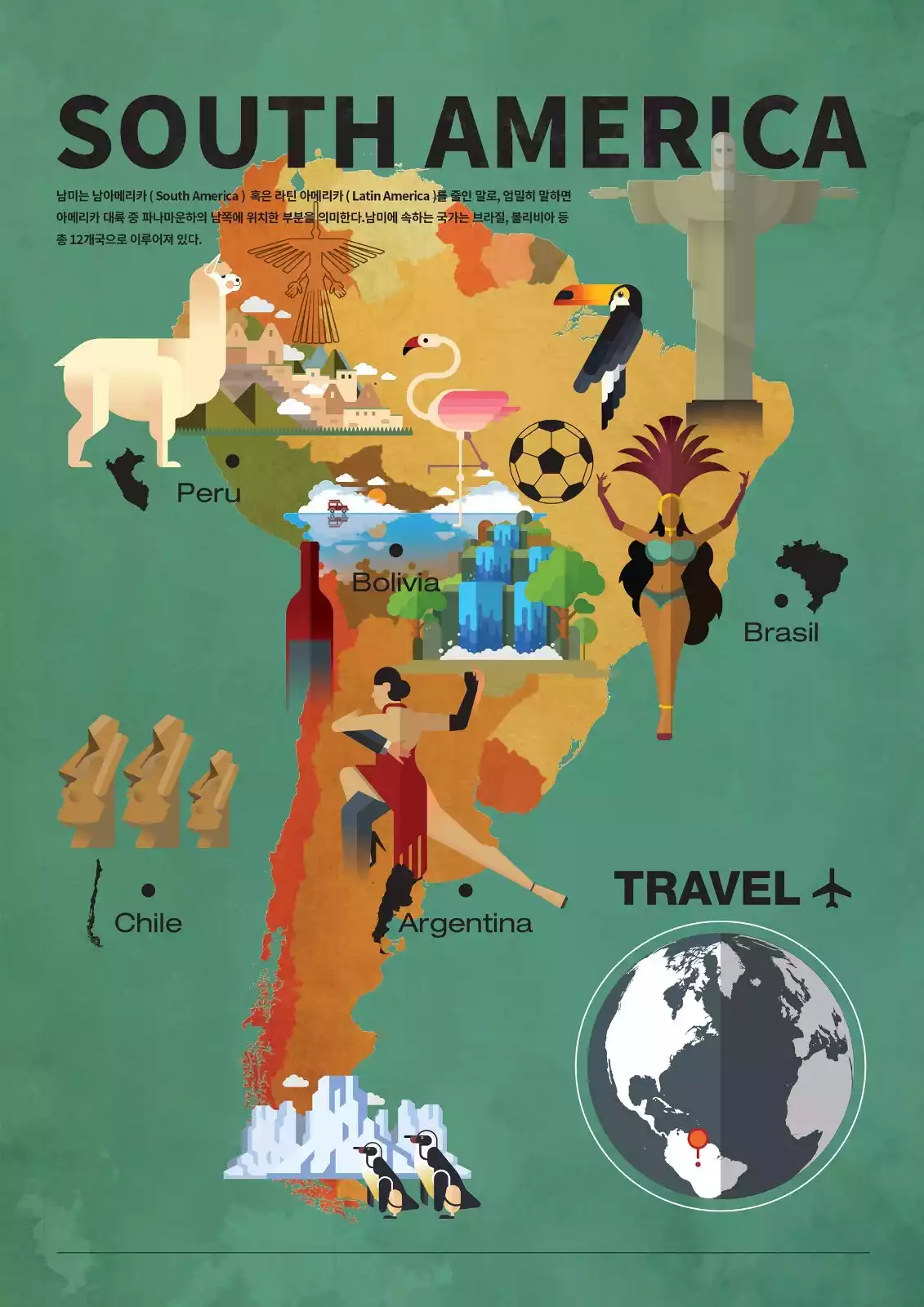
This guide will take you to appreciate the three South American countries with relatively strong comprehensive strength: ABC (Argentina + Brazil + Chile) - Argentina, Brazil and Chile.
Chile - Top 1 Best Country to Travel in 2018
Chilecheck the details
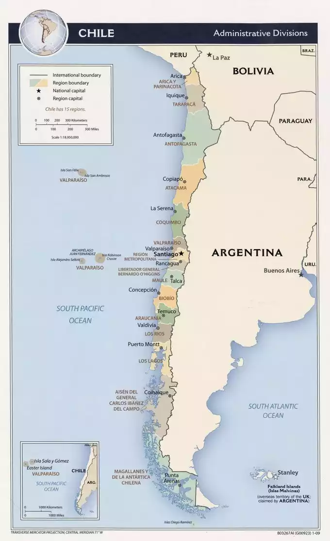
The Republic of Chile (Spanish: República de Chile) is located in southwestern South America, at the western foot of the Andes Mountains. Bordered by Argentina to the east, Peru and Bolivia to the north, the Pacific Ocean to the west, and Antarctica to the south, Chile is the world's narrowest country, with a land area of 756,626 square kilometers. A member of the Union of South American Nations (UNAM), Chile is ranked alongside Argentina and Brazil as one of the "ABC Powers" in South America. Chile boasts abundant mineral, forest, and fishery resources. Chile is the world's richest copper producer and exporter, earning it the nickname "Copper Kingdom." The Atacama Desert, home to the world's driest desert, is also the only country in the world to produce saltpeter. Chile also ranks highly in press freedom, the Human Development Index, and democratic development. Chile boasts a highly developed education system, widely recognized by developed countries. Due to its location at the southernmost tip of the American continent, across the sea from Antarctica, Chileans often refer to their country as "the land at the end of the world."
8055 recommendations, 8245 visits
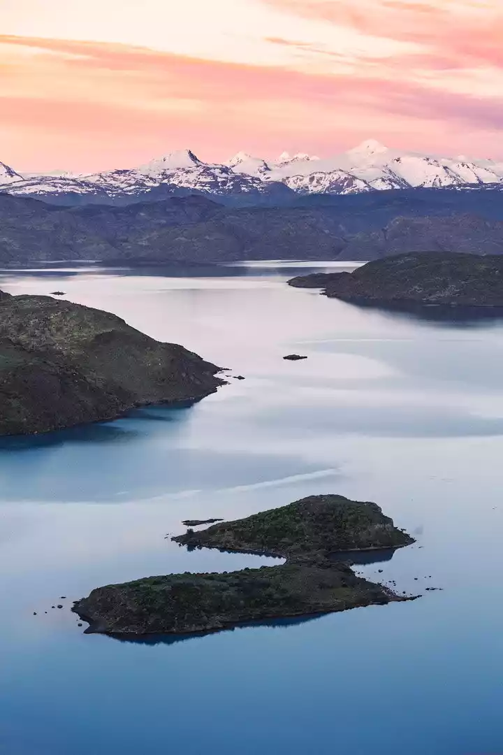
Chile boasts the world's longest and narrowest terrain, resulting in strikingly different scenery between its north and south. Traveling from left to right across the country takes only about three hours! The central region, home to the capital, Santiago, boasts distinct seasons and a Mediterranean climate, making it Chile's most vibrant region.
Chile is geographically isolated from South America, with the towering Andes Mountains to the east, the vast Pacific Ocean to the west, the waterless Atacama Desert to the north, and the desolate and inaccessible Patagonia region to the south.
Someone described Chile like this: "After God created the world, he had many special and beautiful things left over and didn't know where to put them, so he put them all together and formed Chile."
For centuries, Chile has been known as "the end of the world." Pablo Neruda once described Chile as "my thin country," yet this "thin" land harbors wonders. It's a wild, isolated paradise, another planet at the end of the world.
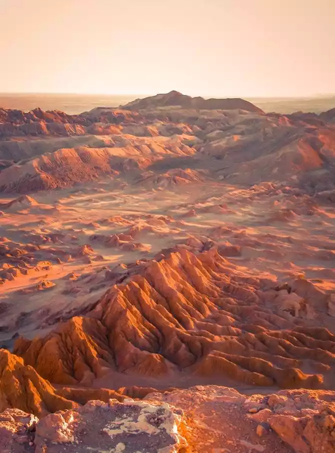
Atacama Desert - A walk on the surface of Mars
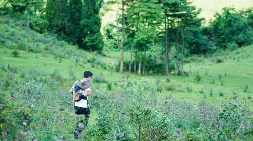
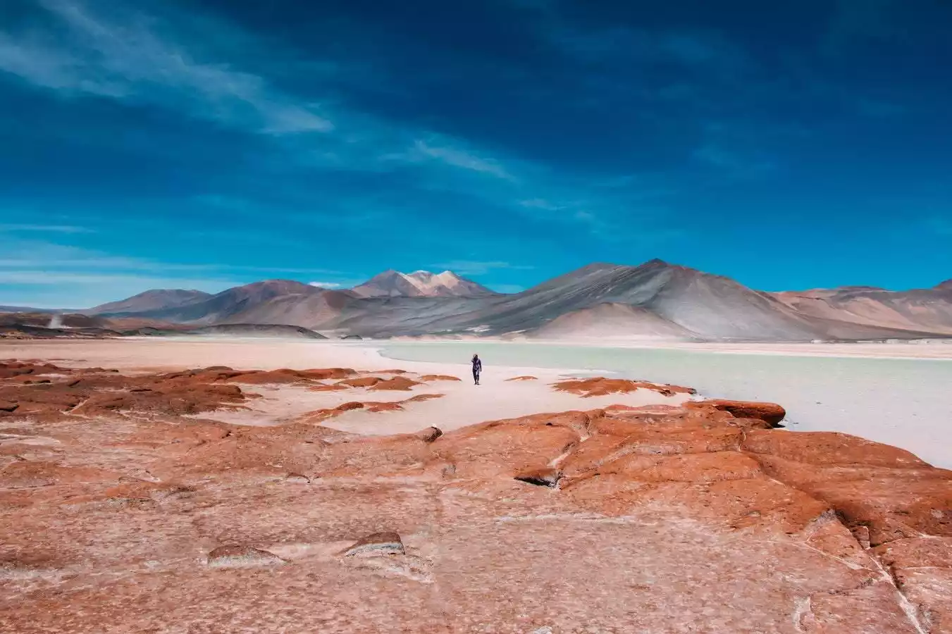
We always think that deserts are exclusive to Africa, but in fact there is also a desert in Atacama, Chile. It is one of the driest places in the world. From 1845 to 1936, there was not a drop of rain for 91 years.
The Atacama Desert formed 15 million years earlier than California's Death Valley, yet its rainfall is only 1% of that of Death Valley. The Andes Mountains to the east of the desert block moisture from the Atlantic Ocean. Although the Atacama extends to the coast, the prevailing downwelling winds there, coupled with the passage of the cool Peru Current, make it difficult for rain to form. These factors combine to make the Atacama Desert the driest place in the world.
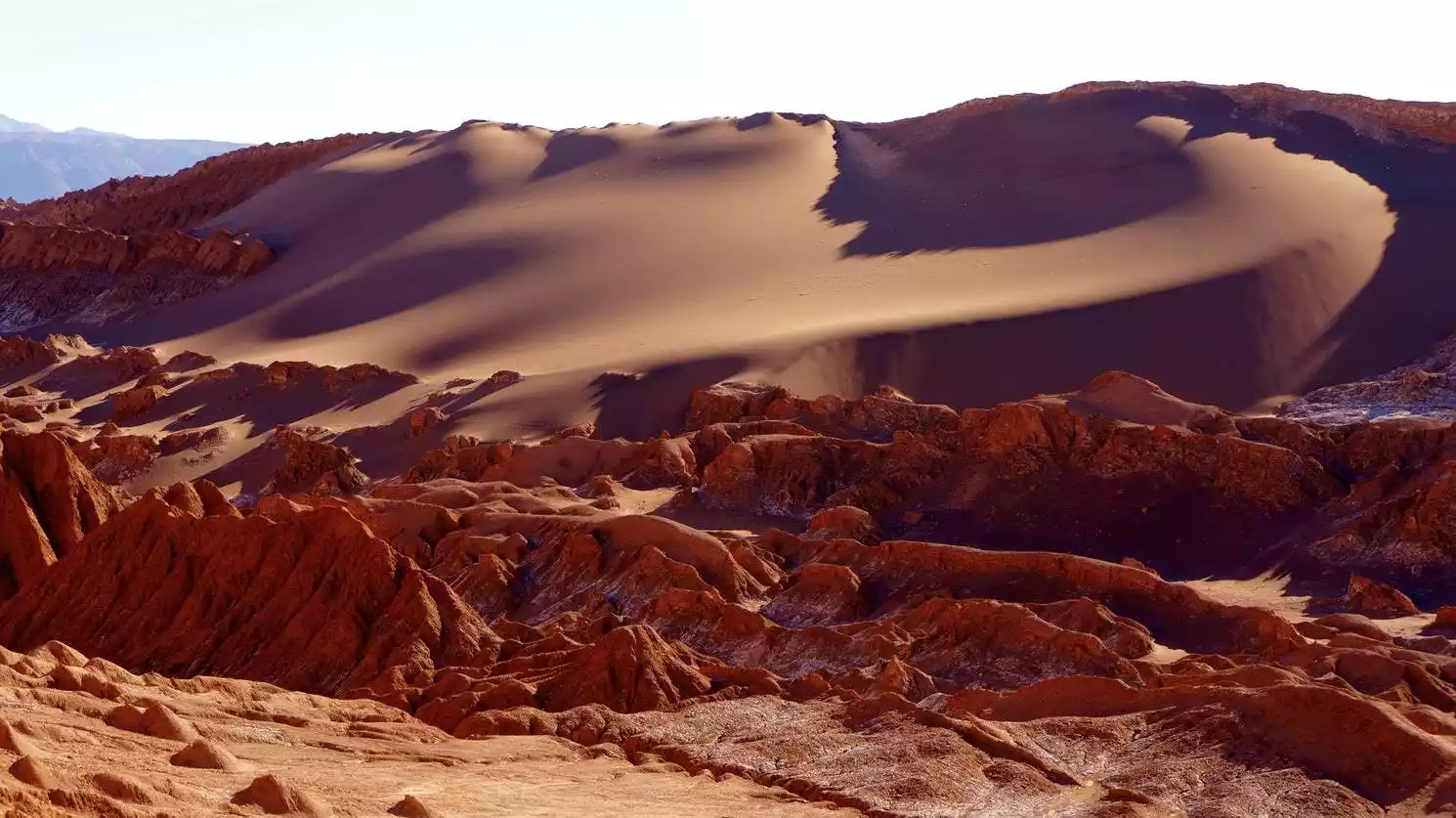
There is no rain here year-round, and very few organisms can survive. In some areas, there is no sign of life at all. This drought and low rainfall seem to be comparable to biological phenomena on Mars.
You may not be able to set foot on Mars in this lifetime, but you can come to Atacama to experience the environment where people will migrate in the future. This place is not just a dead sandy place, but also has beautiful scenery beyond your imagination.
Nitrates have been found in both the Atacama Desert and Mars, as evidenced by the years of drought there. NASA even simulated the Martian environment in the Atacama to test probes. The potatoes grown on Mars in "The Martian" were actually potatoes grown experimentally in the Atacama.
The magical climate here doesn't end there. The 2015 El Niño phenomenon brought unprecedented rainfall to the Atacama, causing dormant flower seeds in the desert soil to suddenly germinate, grow, and bloom, blossoming in the previously silent desert. This "desierto florido" (desert flowering) phenomenon only occurs every five to seven years, so witnessing it is truly a matter of luck.
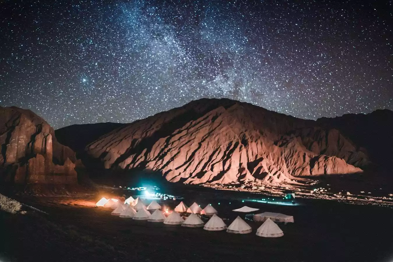
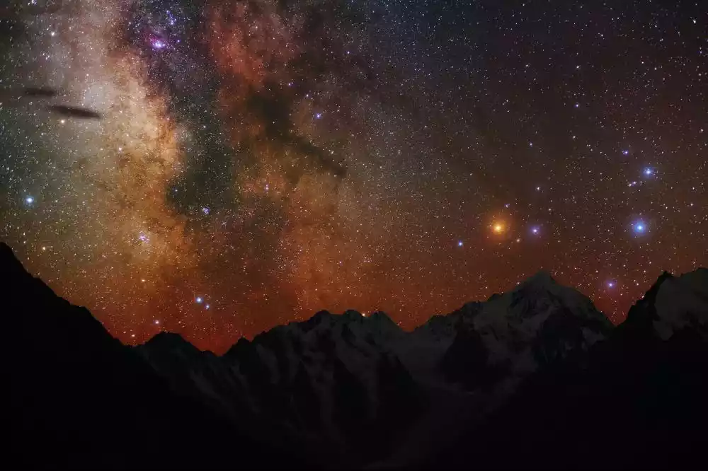
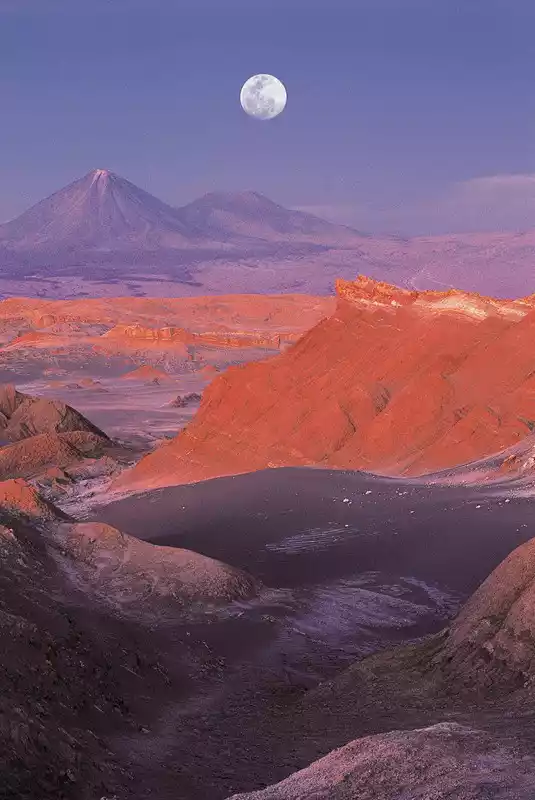
/Enjoy professional stargazing at a top stargazing spot/
Professor Do Min-joon from "My Love from the Star" gave Cheon Song-yi's younger brother a stack of star maps he took in the Atacama Desert, telling him, "San Pedro de Atacama, Chile is the best place in the world to see the stars."
All major hotel chains offer stargazing itineraries that can fully meet the needs of beginner stargazing enthusiasts. Bookings can be made in advance with travel agencies.
However, you must avoid stargazing under a full moon, because the light of a full moon is too bright and will affect the light of other very faint stars, affecting the effect of stargazing.
So if you go to the Atacama Desert for stargazing, be sure to check the full moon time in advance and avoid this time period. There are no stargazing tours 6 days before and after the full moon.
/Hike and sunset in Moon Valley and Death Valley/
This is the closest place on Earth to the view of the moon.
Moon Valley is a typical salt layer accumulation area in the Atacama Desert. Due to its special terrain structure, after thousands of years of rain erosion, a large amount of salt layers have accumulated in this area, forming shiny salt crystals in the soil.
Visit the "3 Marias" in Moon Valley, hike the rock formations, take photos at the "Piedra de Coyote" viewing rock in Death Valley, and watch the Atacama sunset in Death Valley.
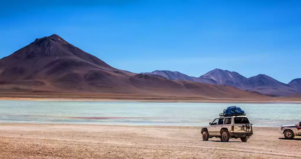
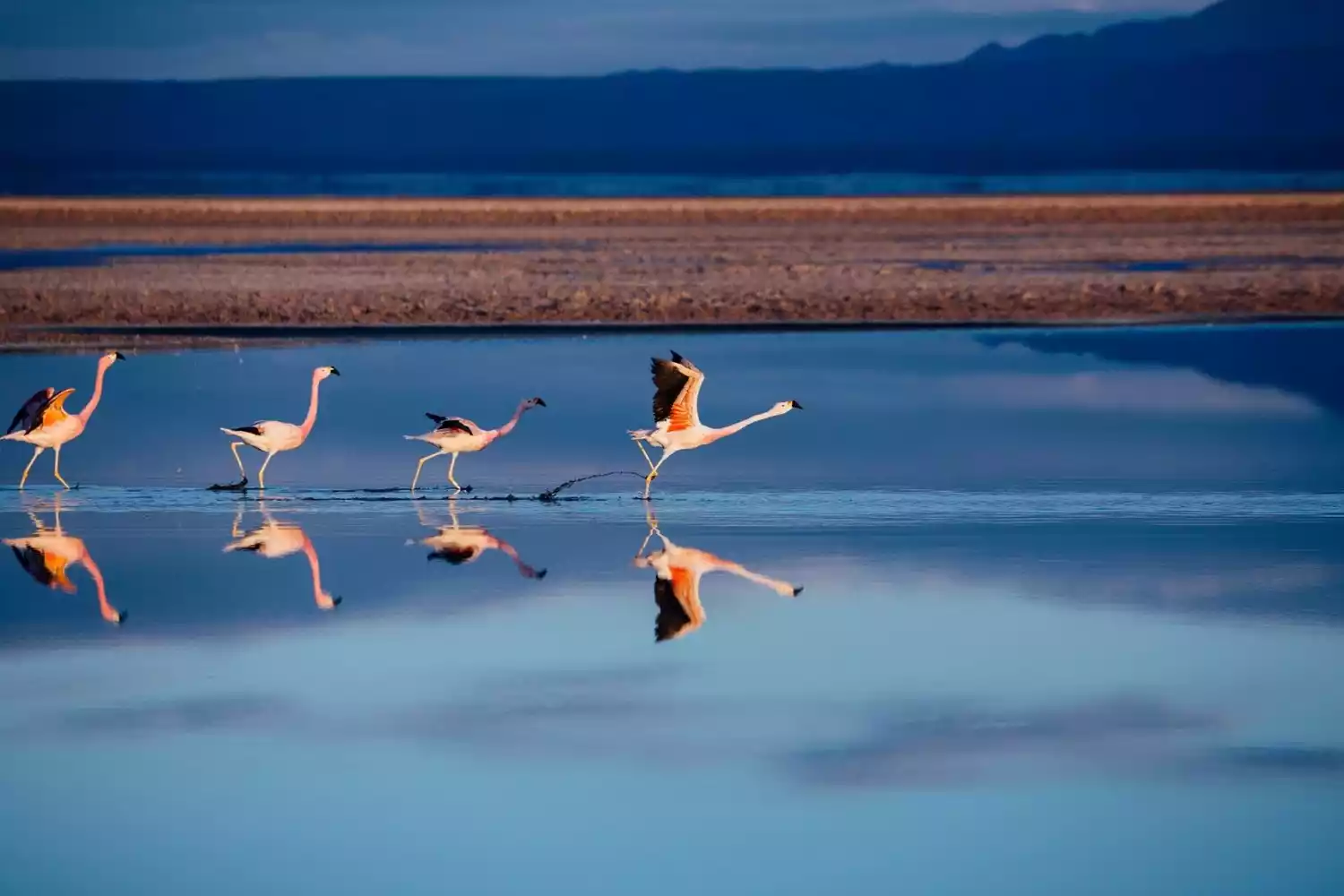
/Flamingo viewing at Atacama Salt Lake/
The largest salt lake in Chile, it is also the second largest salt lake in America and the world, ranking only after Uyuni.
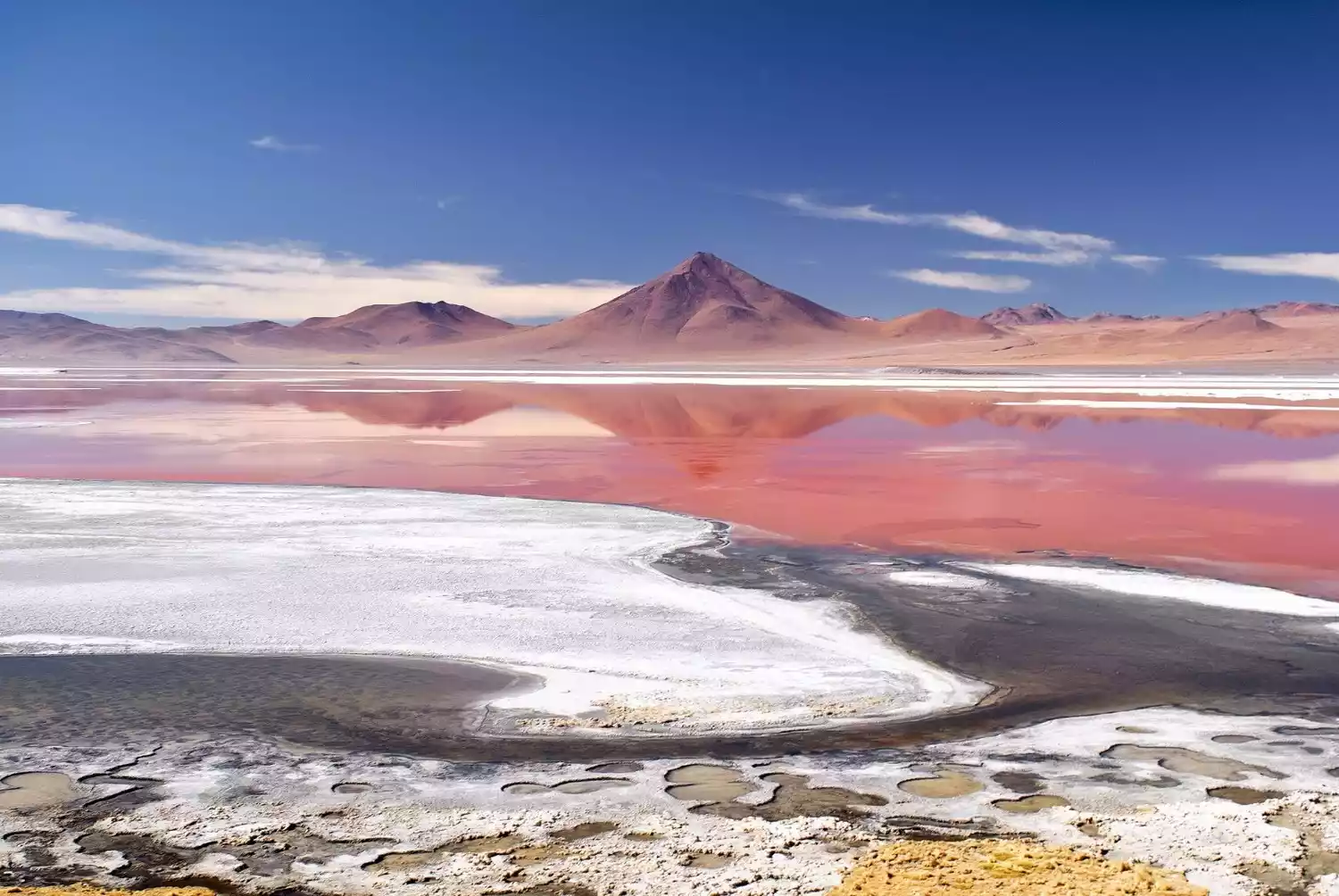
To get here, you need to first go to the village of Toconao, which was the first small village established by the Spanish when they came to the Atacama Desert. The village has preserved the bell tower and church built at that time. The desert residents here use handicrafts made from desert materials to build houses.
The Atacama Salt Lake is home to two species of flamingo: the Chilean and South American. However, due to climate change, the salt lake area is shrinking, posing a significant challenge to the flamingos' survival. After enjoying the salt lake, you can also watch the sunset over the Licancabur volcano by the lake.
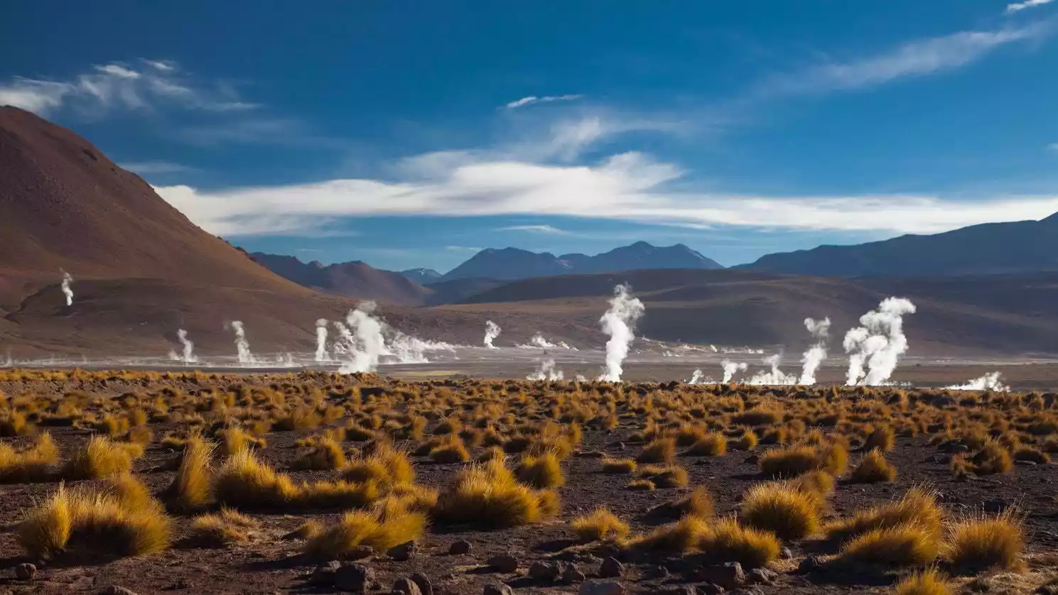
/ Plateau geyser hot springs /
Geysers El Tatio is the highest geyser complex in the world.
This is the habitat of the plateau Vicuña (alpaca), which usually only lives in areas above 3,800 meters above sea level. You will also encounter wild Llama (large alpaca) on the way. After arriving at the geyser, you can take a bath in the specially opened hot spring pool, or use the geothermal heat to boil eggs for breakfast.
/Salt Lake Swimming - Little Sky Realm/
The beautiful "Dead Sea" in the Atacama Desert.
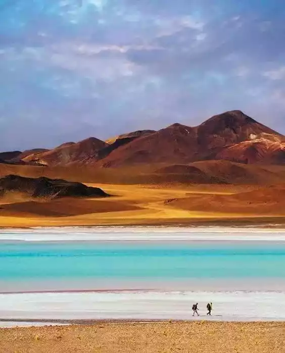
This lake area is located around Salar Atacama. The salt content in the water of Cejar Salt Lake is as high as 40%. People can easily float on the water. You can bring a swimsuit to swim here and enjoy 1 hour of relaxation here.

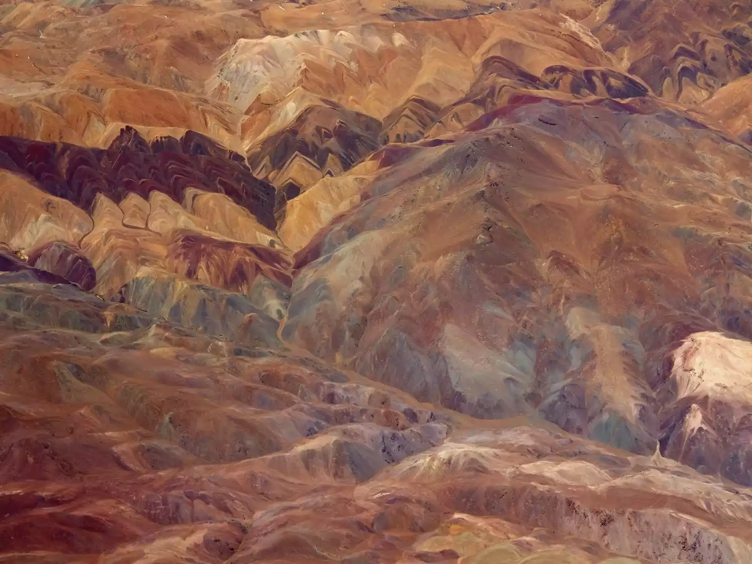
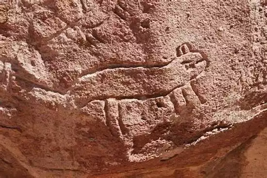
/Rainbow Valley-Rock Paintings/
Valle de Arco Iris + Petroglifos is a cultural journey through the Atacama Desert.
Drive to Yerbas Buenas, a group of hard rocks in the desert with various images left on the stones by ancient residents, including animals and people. The ancient lines here record the life of the Lican-Antay civilization living in the desert area.
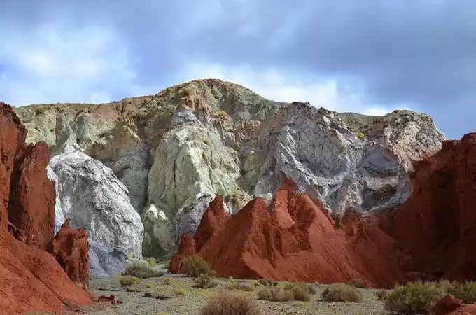
Rainbow Valley, due to the special geological structure, the mountains here have formed various colors, and many mountains have a history of 600 million years.
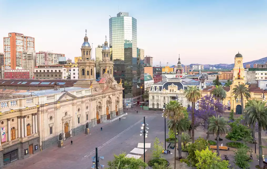
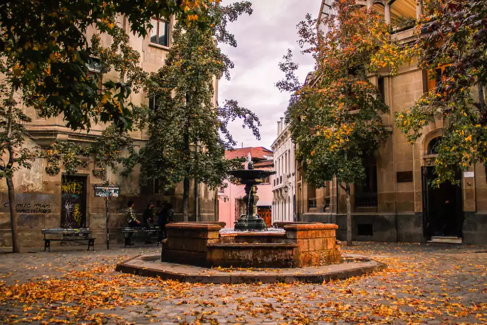
The capital, Santiago, is a modern and livable city surrounded by snow-capped mountains.
Santiago, the capital of Chile, boasts a 400-year-old history. Strolling through the colonial heart of the old town, past key buildings like the Plaza de Armas, the Central Post Office, Santiago Cathedral, the Chilean History Museum, and City Hall, you'll be captivated by the exquisite sculptures, lintels, and overall architecture.
It borders the South Pacific Ocean to the west and the Andes Mountains to the east. On one side is the magnificent ocean, and on the other side are mountains covered with snow all year round. You can drive between the two places for 40 minutes to freely switch between the unique beauty of the sea and the mountains.
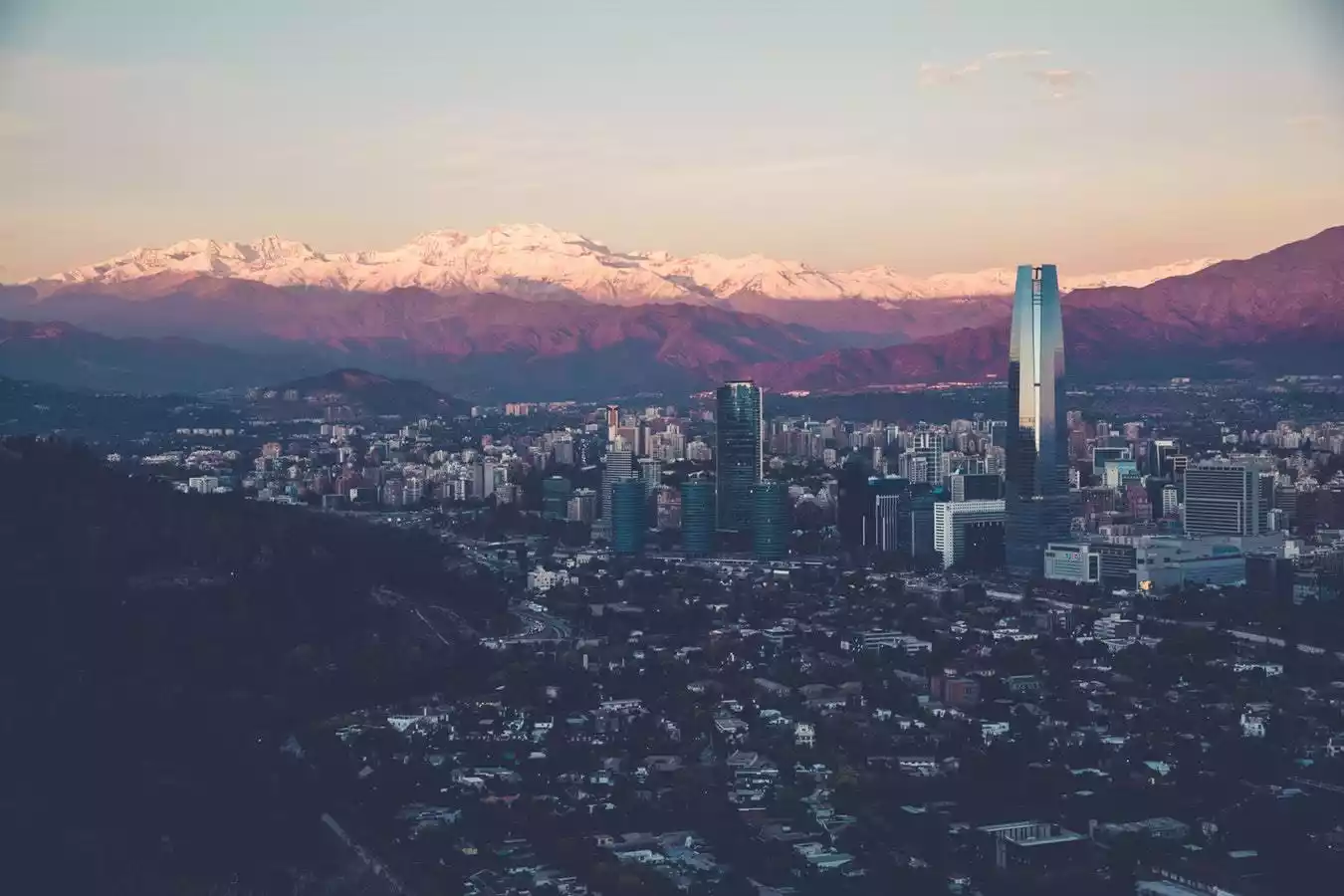
Walking through the streets of Santiago, you will see modern skyscrapers and colonial buildings full of historical charm standing side by side, giving you a feeling of wandering between the past and the present, which is quite interesting.
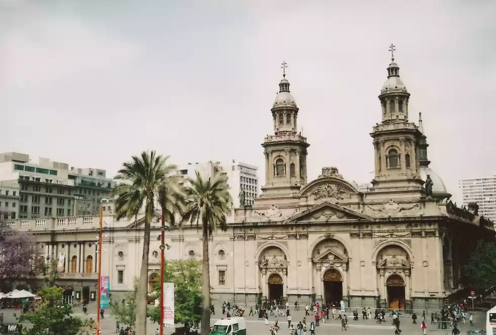
/Plaza de Armas/
Stroll through the colonial-era old town center and discover traces of history among the ancient buildings. Plaza de Armas is Santiago's most important square and the centerpiece of the grid-like layout of Santiago's colonial-era old town.
There are several metal plates on the ground of the square, which record the founding time of Santiago and the evolution of the urban area, allowing travelers to have an intuitive understanding of the history of the city of Santiago.
The square is surrounded by many historic buildings, including the Santiago Cathedral (Catedral Metropolitana), the Santiago Central Post Office (Correo Central de Santiago) and the Santiago Royal Courts (Palacio de la Real Audiencia de Santiago).
Today, the Plaza de Armas has become a gathering place for Peruvian immigrants, and the area is dotted with Peruvian restaurants and grocery stores, making it a unique destination. The pedestrian street near the square is bustling with street performers, especially on weekends. We recommend enjoying the Chilean handkerchief dance and the performances by the troupe of bass drummers.
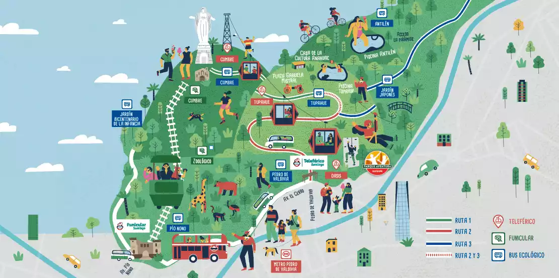
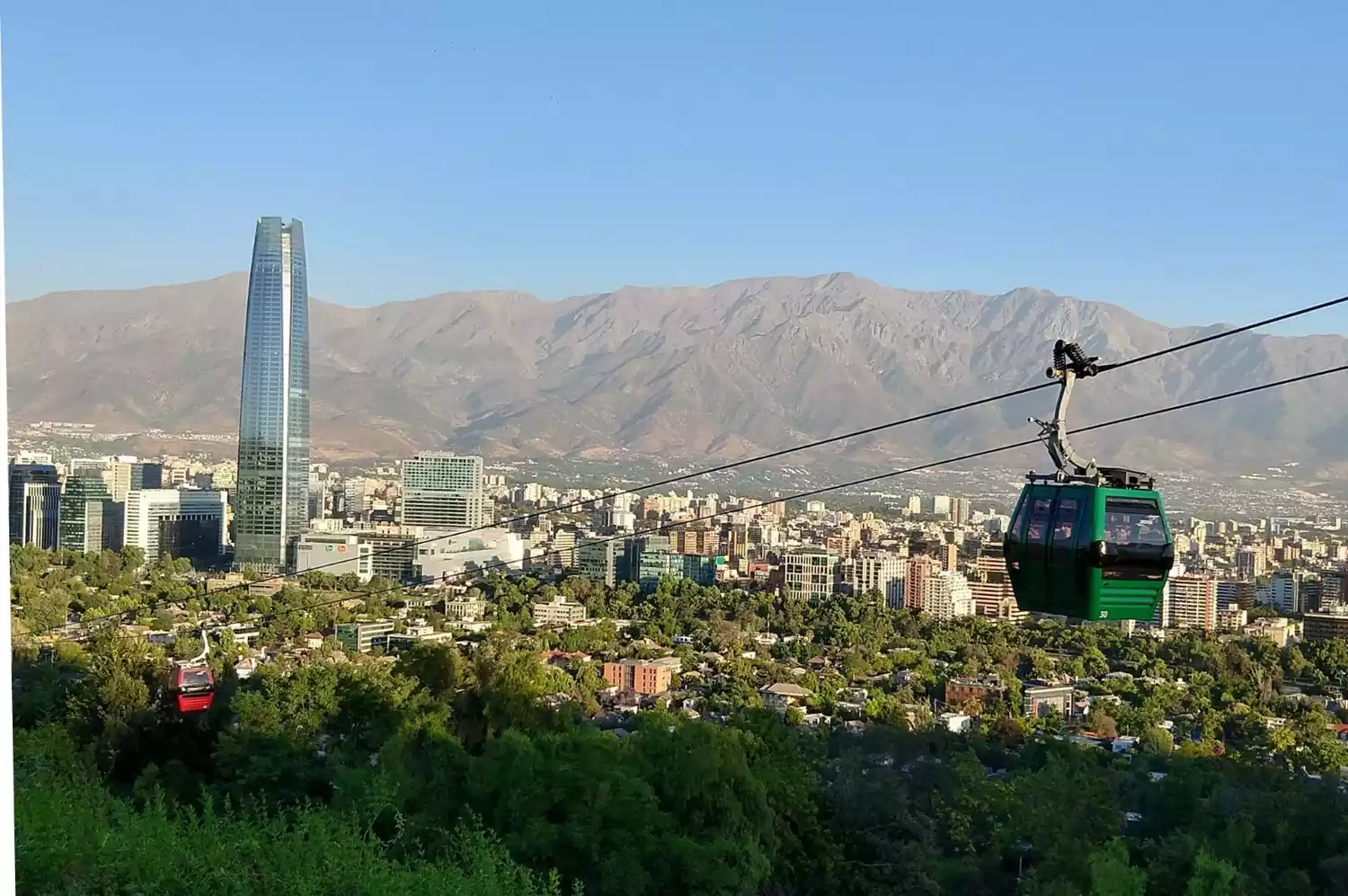
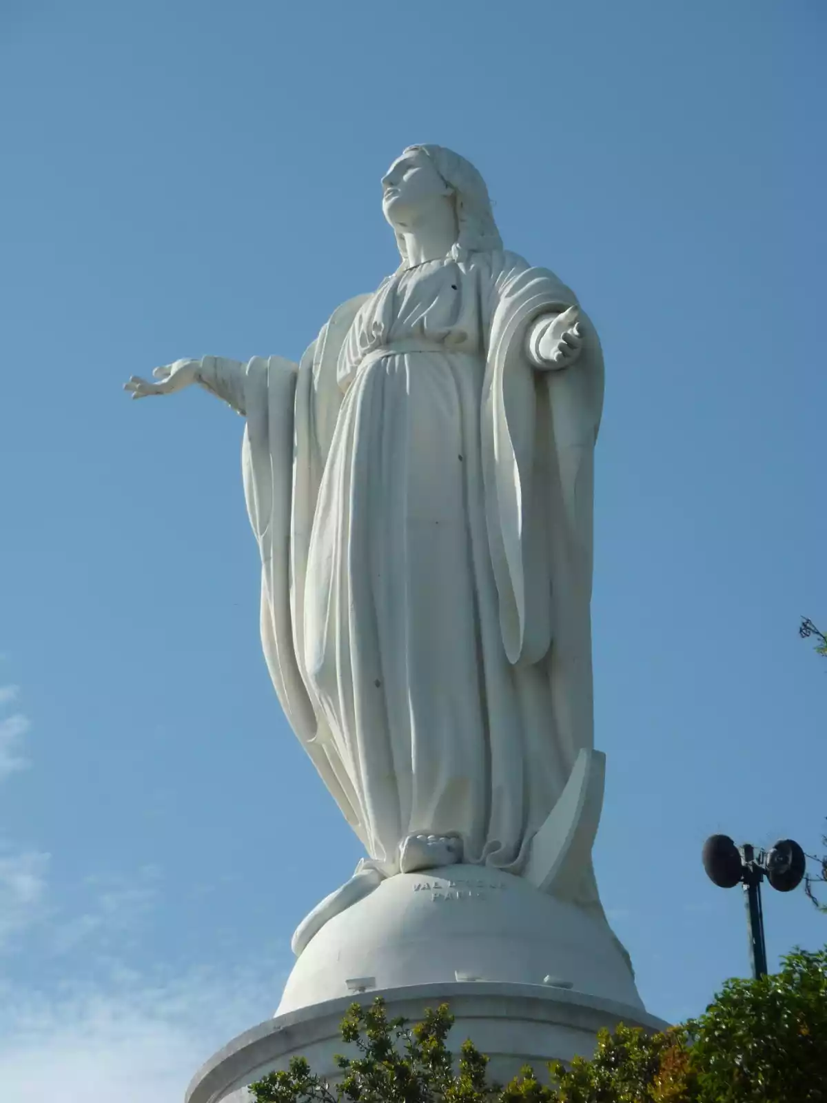
/Metropolitan Park/
The Metropolitan Park is built on a hillside and covers a huge area. Cerro San Cristóbal is located here. The park also includes two swimming pools (Piscina Tupahue and Piscina Antilén), a zoo, a botanical garden, a Japanese garden, picnic areas, etc.
Cerro San Cristobal is a great place to view the cityscape of Santiago. When the weather is clear, you can see the majestic Andes and enjoy the beautiful scenery of the sunset and the mountains dyed in all colors. There is also a huge white statue of the Virgin Mary on the top of the mountain.
I recommend that you take the cable car up the mountain. This cable car was built in 1925 and is 500 meters long. Because Chile has an uneven terrain, this small train pulled by steel cables on rails was used to facilitate the transportation of personnel and supplies.
/Cathedral of Santiago/
Santiago Metropolitan Cathedral (Catedral Metropolitana) is one of the largest churches in Santiago. It is a neoclassical building built in the second half of the 18th century and took on its current appearance in the late 19th century. The interior decoration is both gorgeous and not tacky. During Christmas, there will be decorations such as stables and colorful lights, which creates a very atmospheric atmosphere.
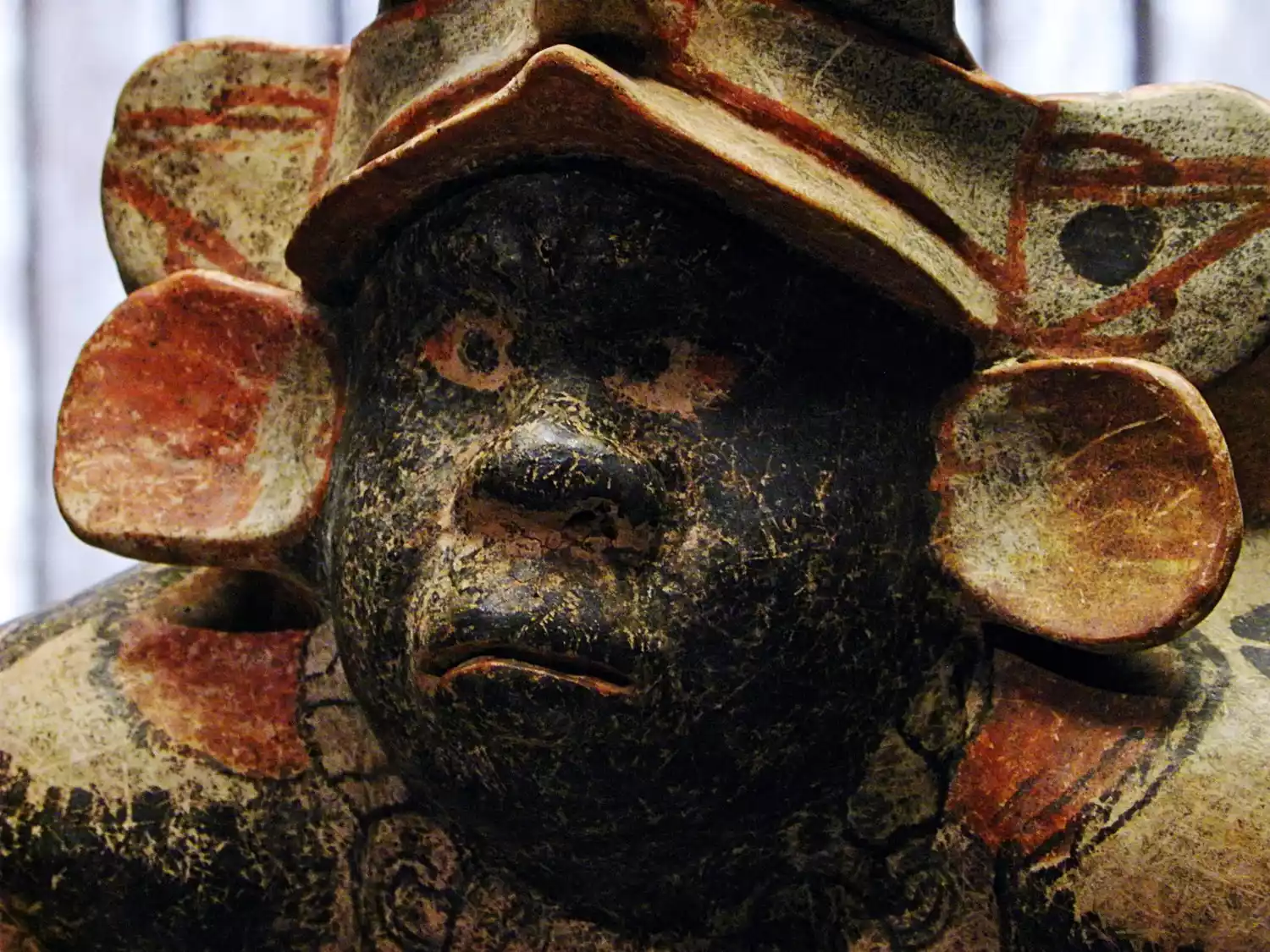
/Museum of Pre-Columbian Art of Chile/
The Chilean Pre-Columbian Art Museum (Museo Chileno de Arte Precolombino) is located near the Plaza de Armas. It has a rich collection of artifacts from pre-colonial Latin America, including many artifacts from Chile's indigenous peoples. Exhibits also include mummies that are older than Egypt, Mayan stelae, and a large number of indigenous textiles and pottery.
/Mount Santa Lucia/
Santa Lucia Hill is where Santiago was founded and it is also the best place in the city to enjoy the panoramic view of Santiago. When the visibility is high, you can see the modern city against the backdrop of the stretching Andes Mountains.
Biologist Darwin also visited this place during his round-the-world journey to discover the theory of evolution, and his wise words are still engraved on a metal plaque on the top of the mountain.
This small hill, several hundred meters high, is home to ancient castles, fountains, flowers, plants and unusual rocks. There are several winding paths to the top, with changing scenery as you walk. There is also an elevator on the main road, so travelers with limited mobility can use wheelchairs to easily reach the fountain halfway up the mountain to enjoy the beautiful city view.
Opposite Mount Santa Lucia is a souvenir market full of South American style, where interested travelers can also visit.
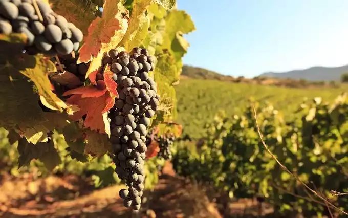
/Experience wine tasting at world-famous wineries and vineyards/
Chilean wine is very famous internationally. Some unique grape varieties, such as Carménère, are almost extinct in their country of origin, France, but are widely grown in Chile.
The hilly area near Santiago has a Mediterranean climate, which is very suitable for growing grapes. Therefore, there are many wineries around the city. Famous wineries include Concha y Toro, Almaviva, Montes, Don Melchor, etc.
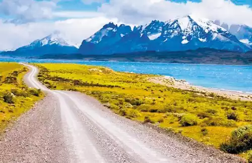
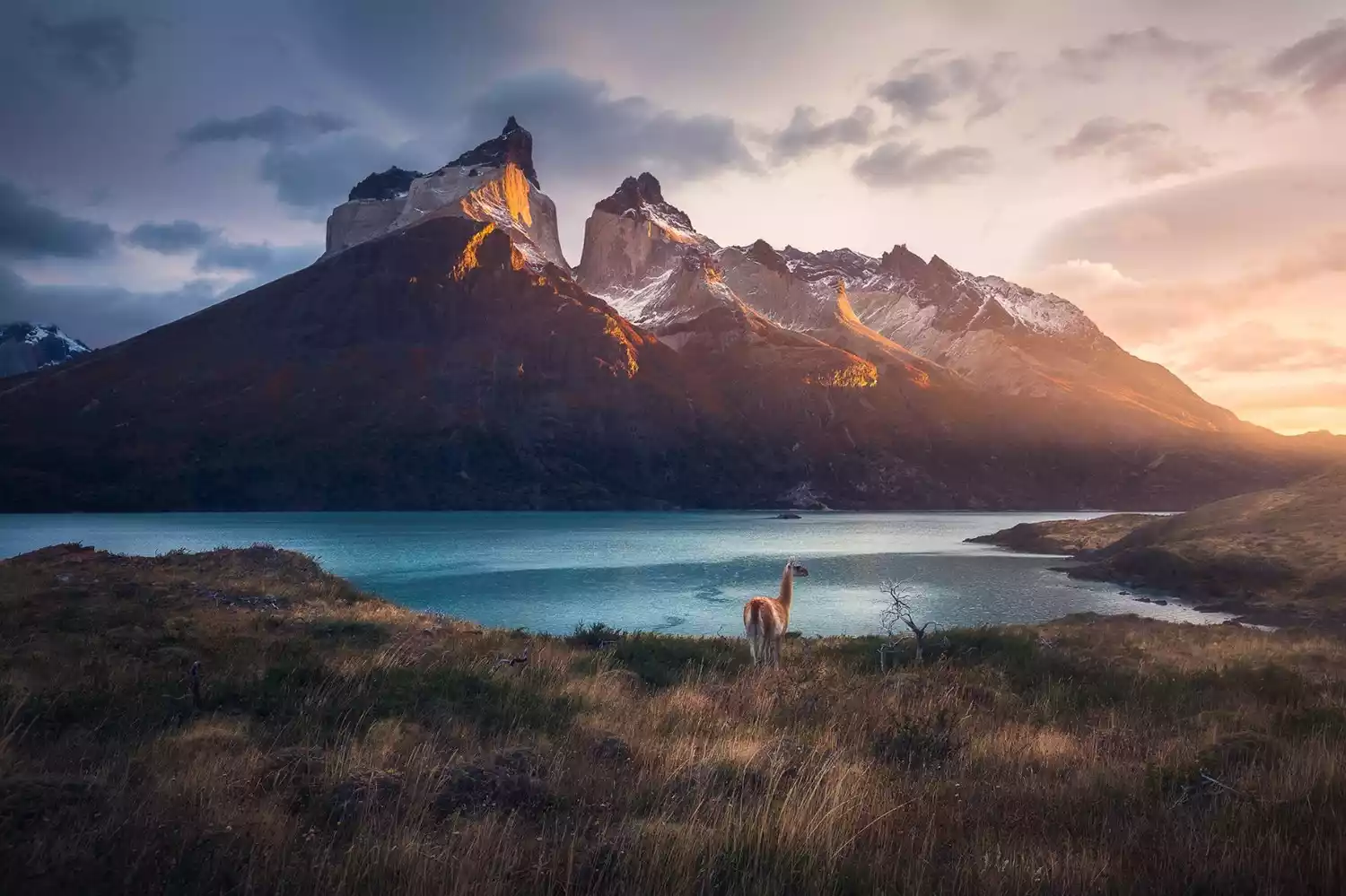
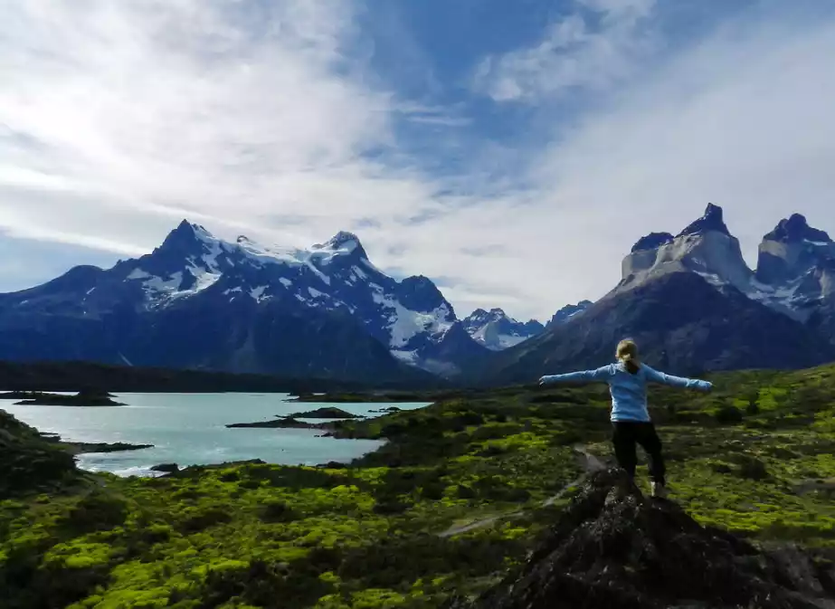
Torres del Paine National Park - Top 5 Scenic Spots in the World
Torres del Paine National Park is hidden at the southern end of the Andes Mountains, in the heart of Chilean Patagonia, and belongs to Chile's XII Region, the Magallanes-Chilean Antarctic Region.
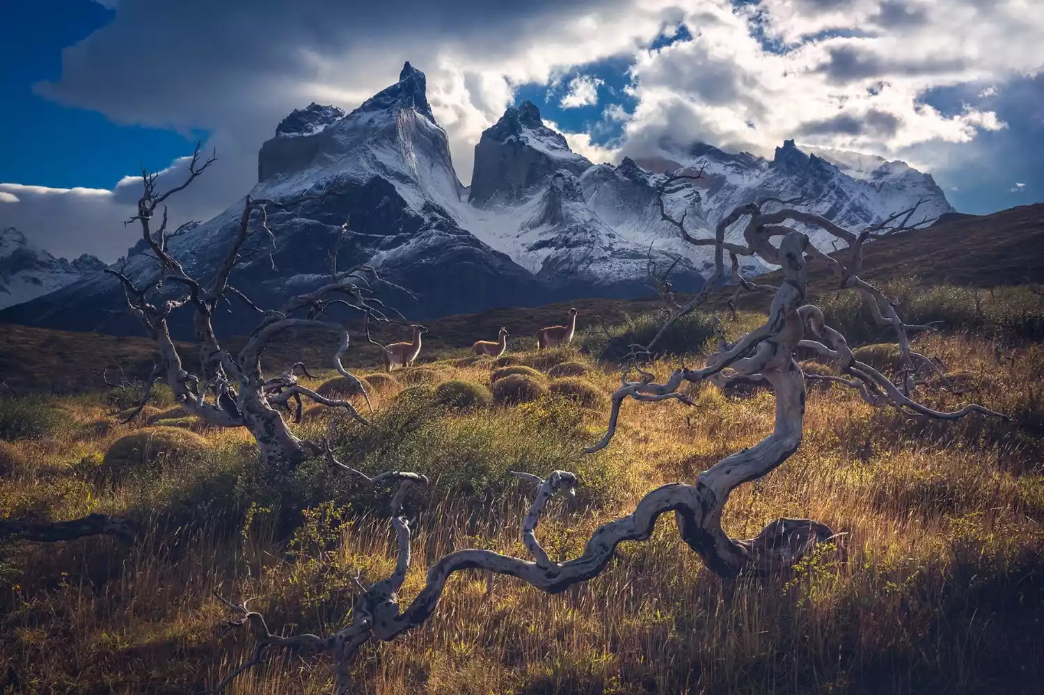
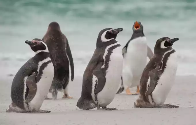
The park was established on May 13, 1959. It is rich in glacier resources and animal resources. Nearly 100 local endemic animals live here, including the Andean eagle, South American llama, pumas, Andean elk, Magellanic woodpecker, Patagonian fox, and magpie.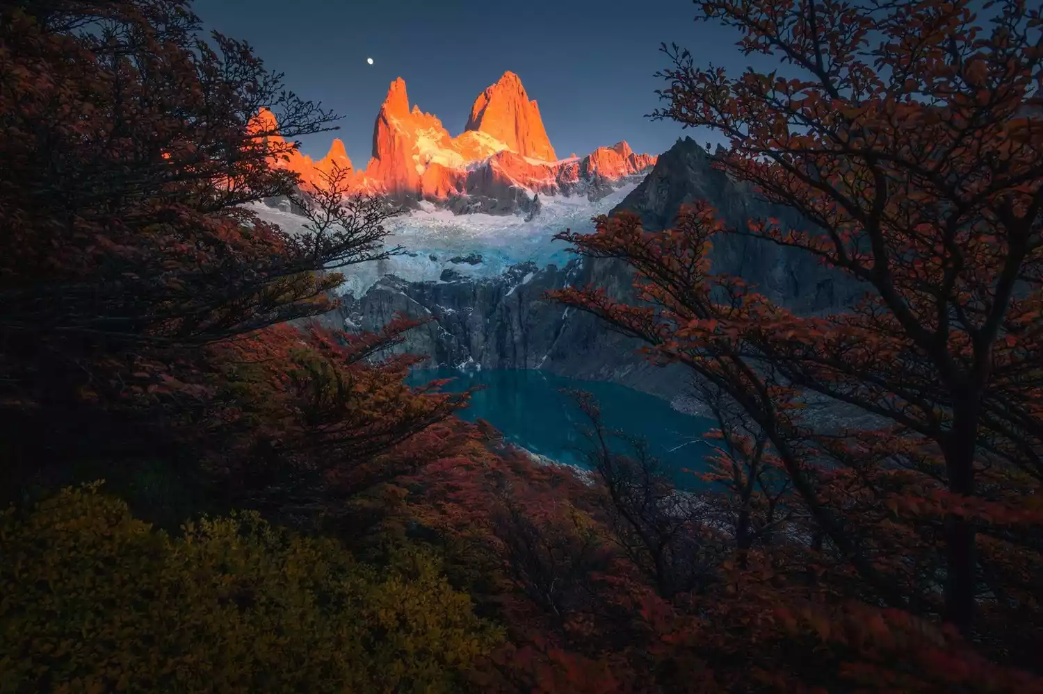
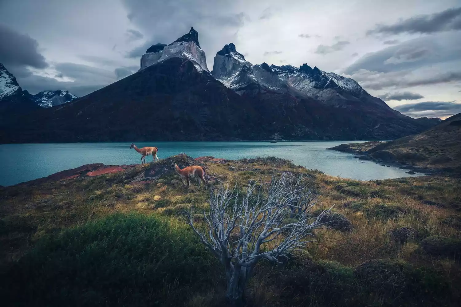
The scenery of Torres del Paine National Park can be summarized into three categories: valleys, lakes, and glaciers. The three major lakes in the center of the park: Lake Nordenschio, Lake Peñue, and Lake Grey divide the park into two parts, north and south.
The mountains are more concentrated on the north side, and the terrain is undulating. The park's most famous peaks, valleys, glaciers and other major attractions, as well as the W and O line hiking routes that are popular among outdoor enthusiasts, are all distributed here.
The terrain on the south side is relatively flat, with rivers and lakes crisscrossing, a self-driving highway passing through here, and some resort hotels are also built here.
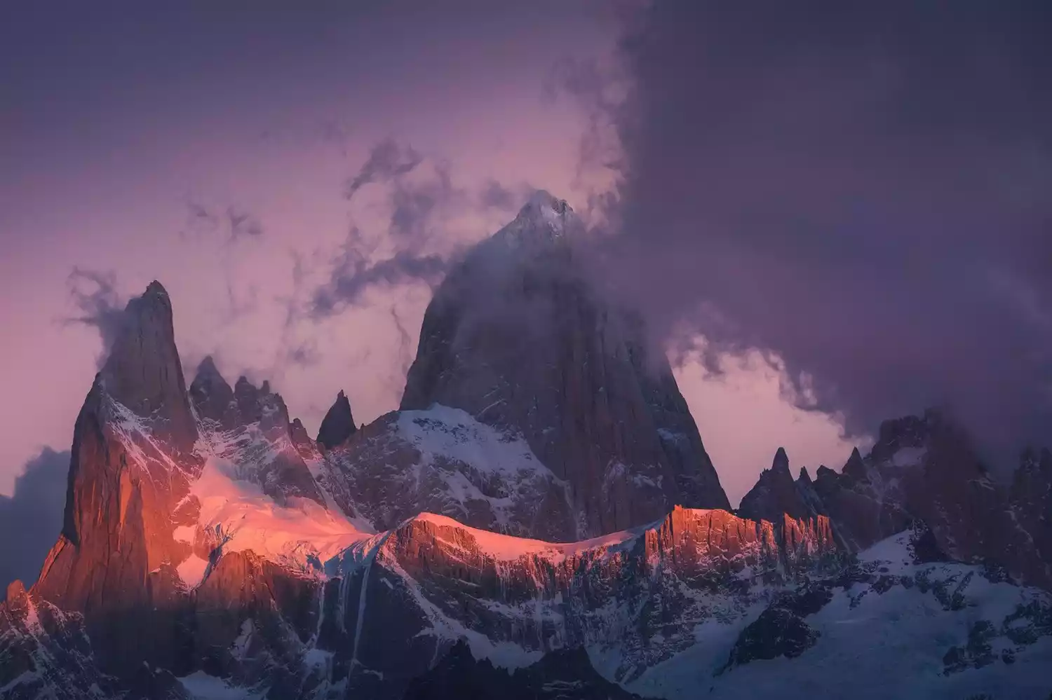
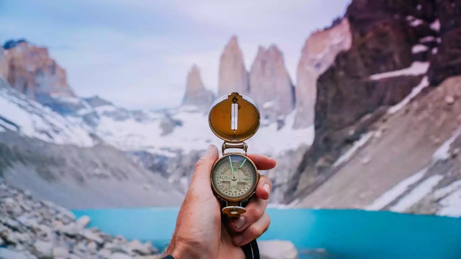
/Three Towers of Torres del Paine/
The Three Towers of Torres del Paine is the most iconic attraction in Torres del Paine National Park. The three peaks rise into the sky like towering spires and are called the "Three Towers". The Three Towers face east and west and are an excellent place to enjoy the sunrise.
/Paine Peak/
Los Cuernos is another most photogenic spot in Torres del Paine National Park. It is named after its shape which resembles a cow's horns. It is located on the west side of the Three Towers Peak. There is a shortcut from the Three Towers to Campamento los Cuernos.
The best place to admire the Horn Peak is on the southeast shore of Lake Peoe, where you can see magical changes in light and shadow regardless of sunrise or sunset.
/Lake Peoe/
The largest lake in Torres del Paine National Park, its waters are a stunning sapphire on sunny days and a captivating turquoise on cloudy days. From Lake Paío, you can enjoy the most iconic and spectacular panoramic views of the Torres del Paine Peak and the main peaks.
/French Valley/
Valle Francés is located in the center of the W hiking route. You can admire the glaciers in the quiet valley, look around at the towering mountains surrounding you, and experience the shock from all directions.
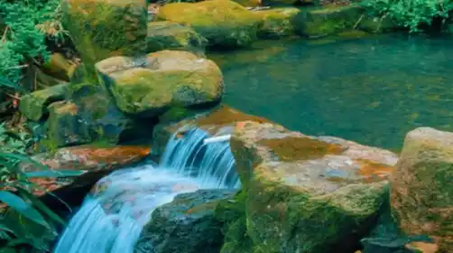
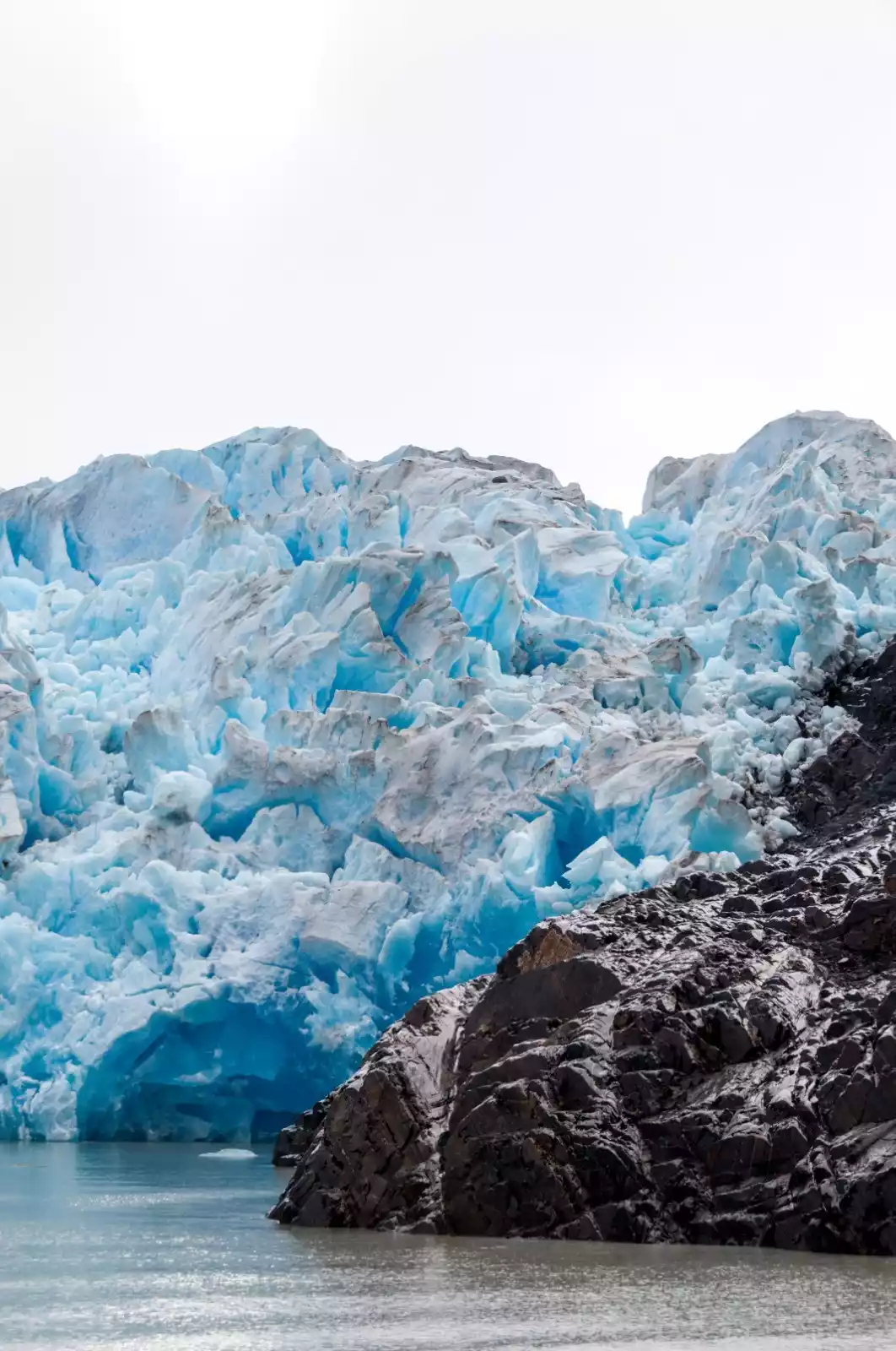
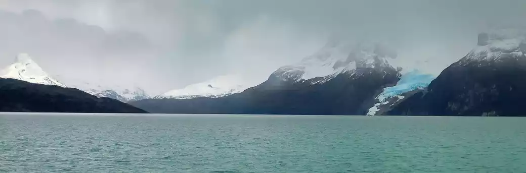
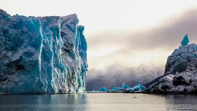
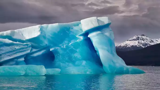
/Grey Glacier/
Part of the Southern Patagonia Ice Field system, Grey Glacier is one of the largest glaciers in Torres del Paine National Park. The entire glacier is 6 kilometers wide and more than 30 meters high.
If you have enough time, you can join a glacier hiking tour, walk deep into the glacier, and feel the ancient cold.
/Mountain Eagle Lookout/
Located on a hillside near the Pehoe paid campground, the Mirador Cóndor (Eagle Lookout) gets its name from the Andean eagles that can be seen flying overhead. From the summit, you can take in a panoramic view of the Torres del Paine Lake area, including key sights such as the horn peaks and the main peaks.
/Last Hope Fjord/
Departing from Bories Pier in Puerto Natales, you can take a boat tour to enjoy the scenery along the Fjord Ultima Esperanza. The entire tour takes about 9 hours, and along the way you will visit attractions such as Bird Island (a heron habitat), Sea Lion Island, Balmaceda Glacier, and Serrano Glacier.
Most tour operators in Puerto Natales offer this tour, which includes a light lunch and hot drinks. This tour operates year-round, with the exception of Holy Week, Christmas, and New Year's Day.
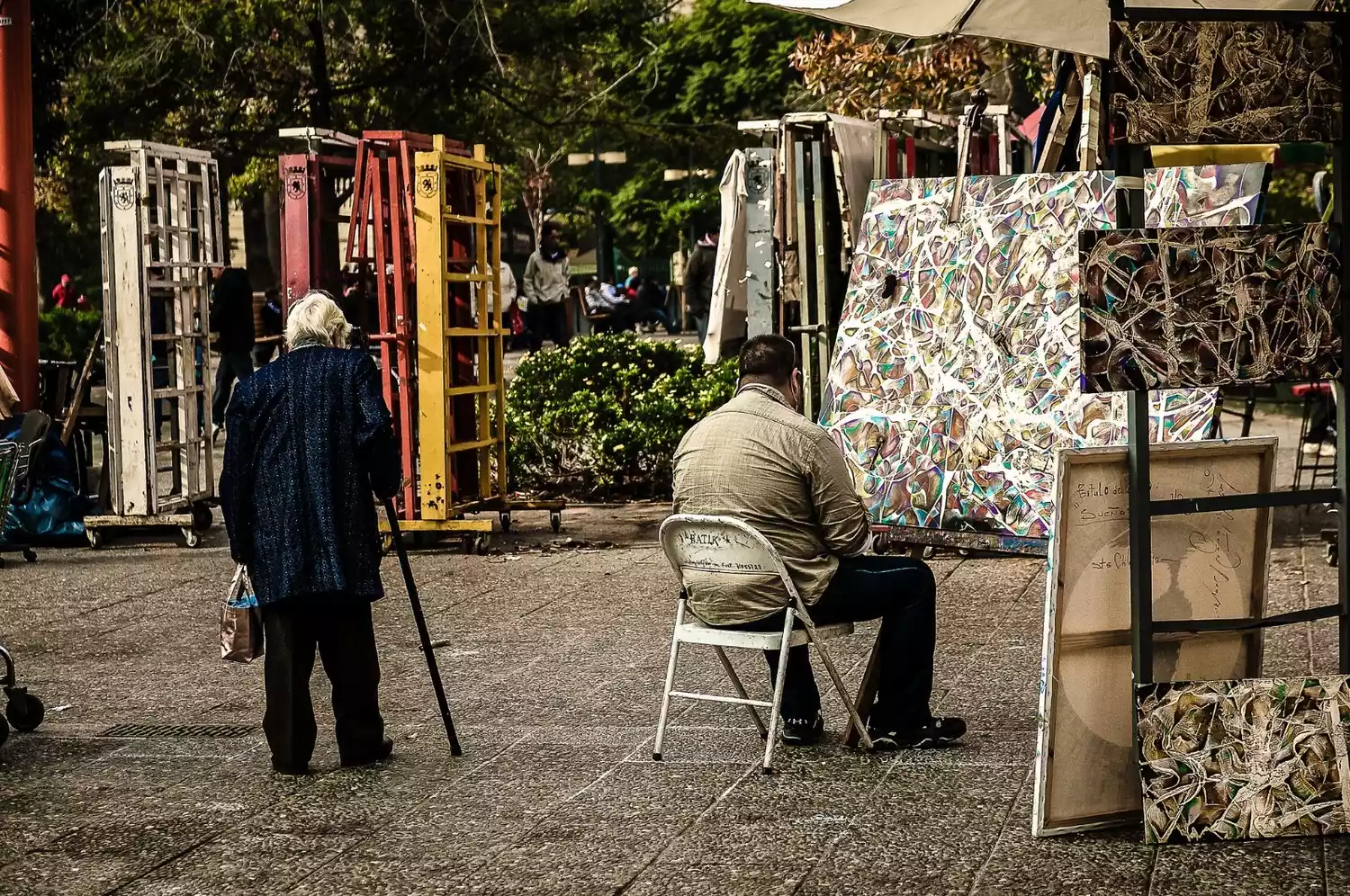
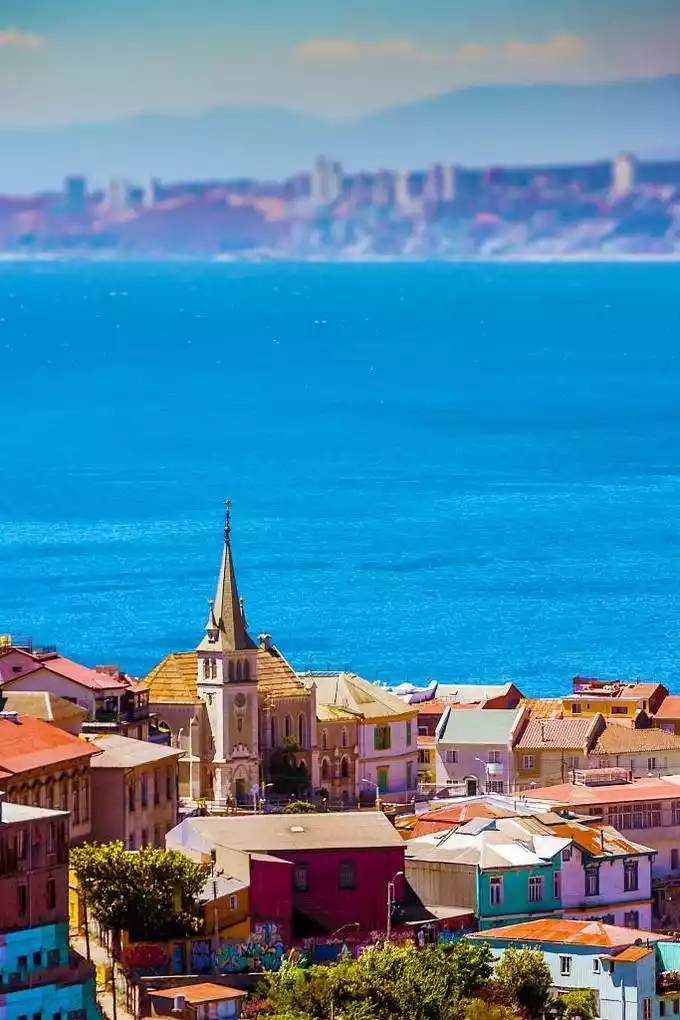
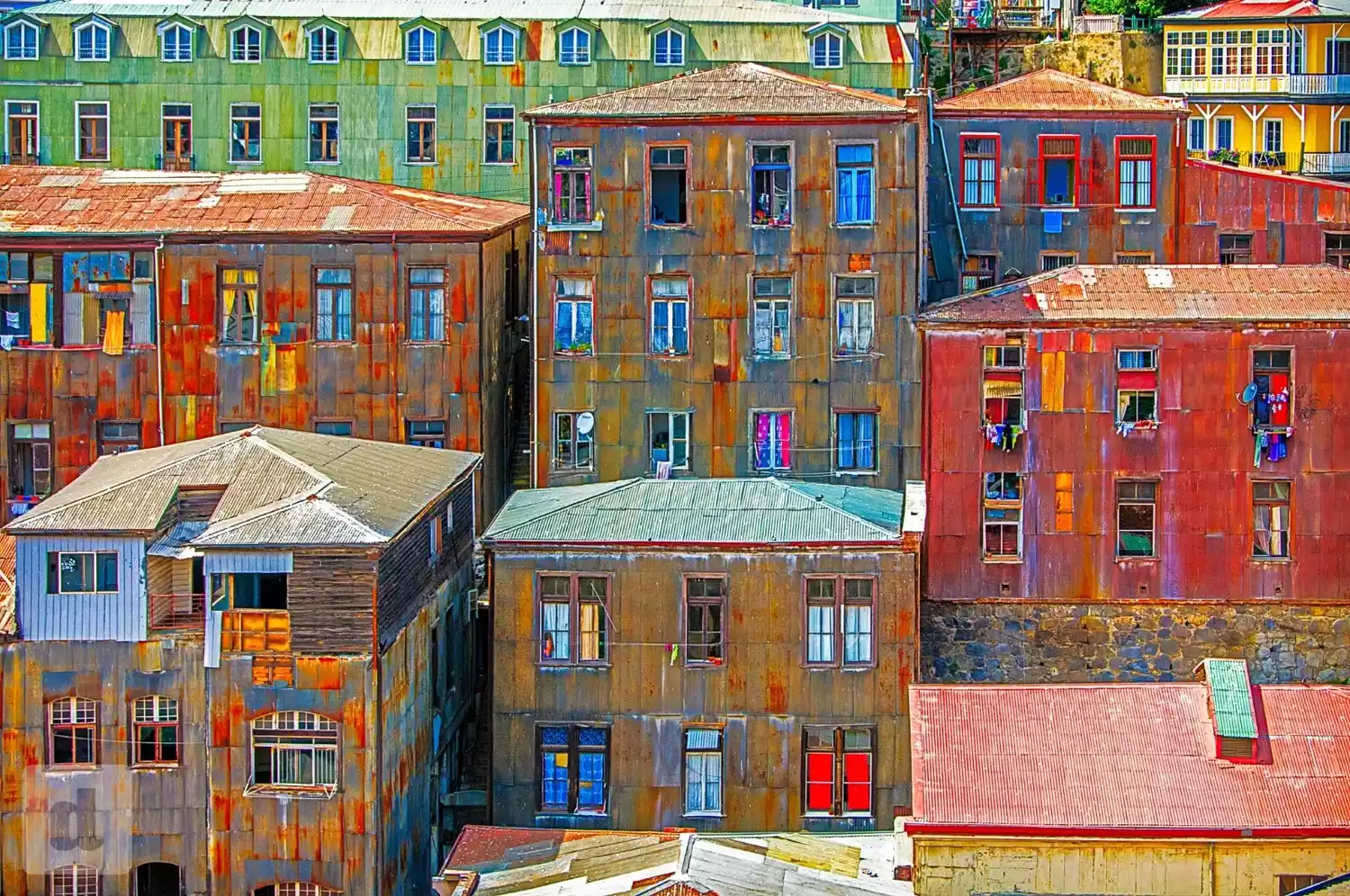
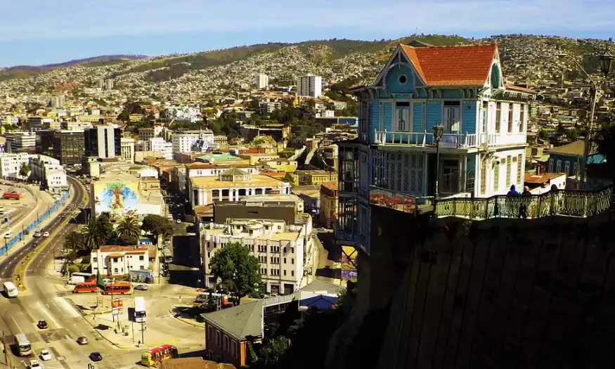
Valparaiso - A Colorful Literary Dream by the Sea
This is a beloved spot for the romantic poet Pablo Neruda, where he and his lover built their dreams. His ideal house was "facing the sea, with spring blossoms" (he actually said this before Haizi did; great minds think alike, I suppose). I recommend his collection, "Twenty Love Poems and a Song of Despair," which will leave you intoxicated by his liquor-like love-talk.
/La Sebastiana, Neruda’s former residence/
La Sebastiana is one of the three former residences in Chile owned by Nobel Prize-winning Chilean poet Pablo Neruda. Tired of life in Santiago, he sought a quiet place to live and write in Valparaíso. La Sebastiana met his requirements: "Neither too high nor too low, quiet nor lonely; in an unassuming neighborhood, neither visible nor audible; with character yet comfortable; plenty of wind, neither too strong nor too weak; remote yet easily accessible; independent yet convenient; and incredibly affordable."
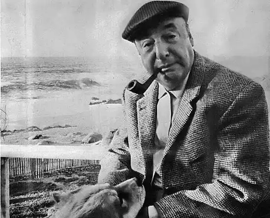
If you have visited Neruda's former residence in Santiago, you must be curious about what kind of house could meet the poet's complex and demanding requirements and prompt him to move here from the capital.
/Open-air Museum/
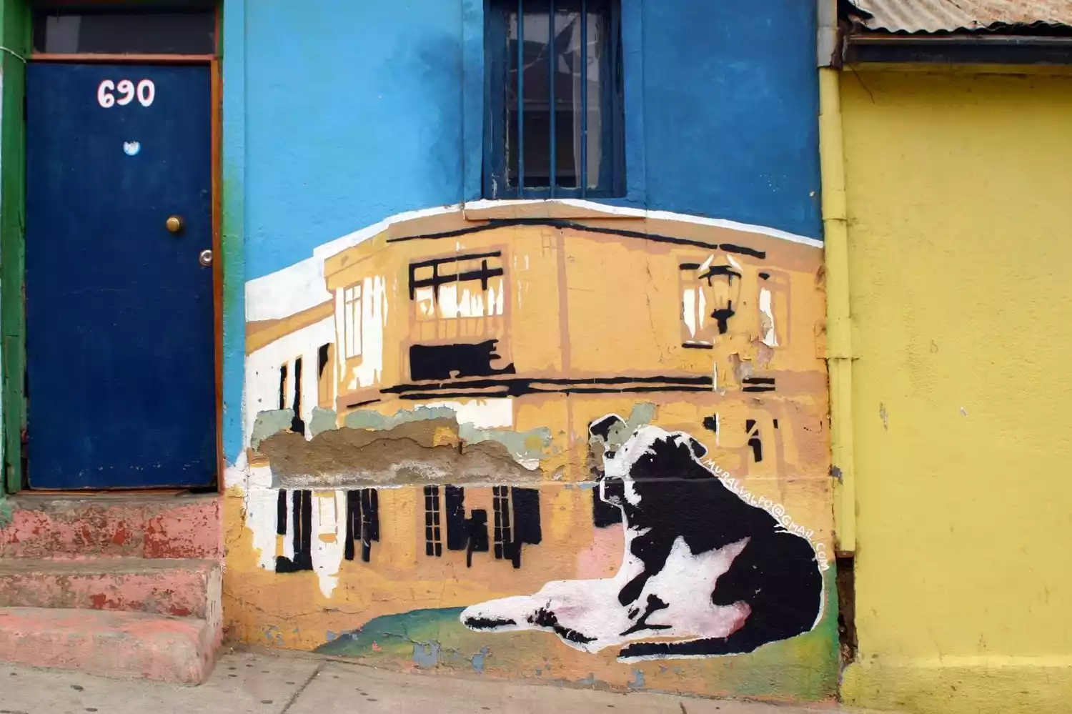
The Open-Air Museum (Museo a Cielo Abierto) is called a museum, but it is actually a very distinctive mural block. It is a collective name for graffiti created on 20 walls by students of the Catholic University School of Art from 1969 to 1973.
Colorful graffiti of various styles are dotted on the walls of the buildings, complemented by the ingenious decorations of the owners of the houses. It is especially suitable for a casual stroll, and many photography enthusiasts come here to take pictures.
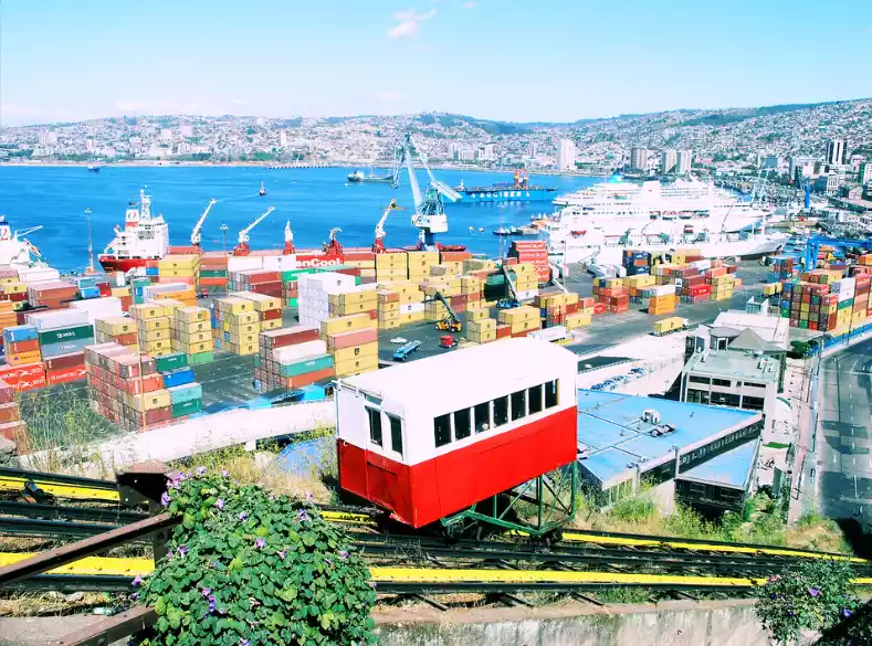
/Cable car/
As early as 1883, several cable cars were built to facilitate residents' access to the mountain. These miniature carriages, resembling elevators and trains, were suspended on tracks with wheels and rails, most of which were inclined at a steep angle of more than 30 degrees.
In 1996, the World Heritage Committee declared Valparaíso's unusual cable car system (a highly inclined cable car) one of the world's 100 endangered historical treasures. Today, 16 of these cable cars still creak and creak, a true antique. A ride is surprisingly affordable, costing 100 Chilean pesos (equivalent to 1 RMB).
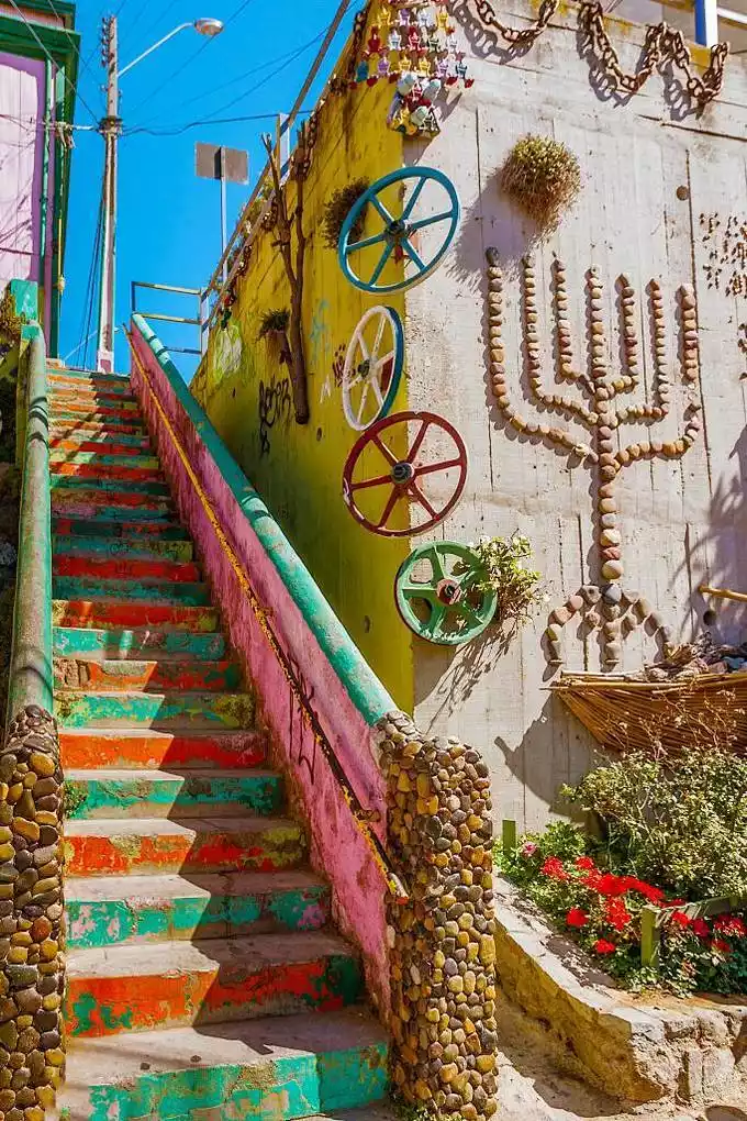
/Landscape Block/
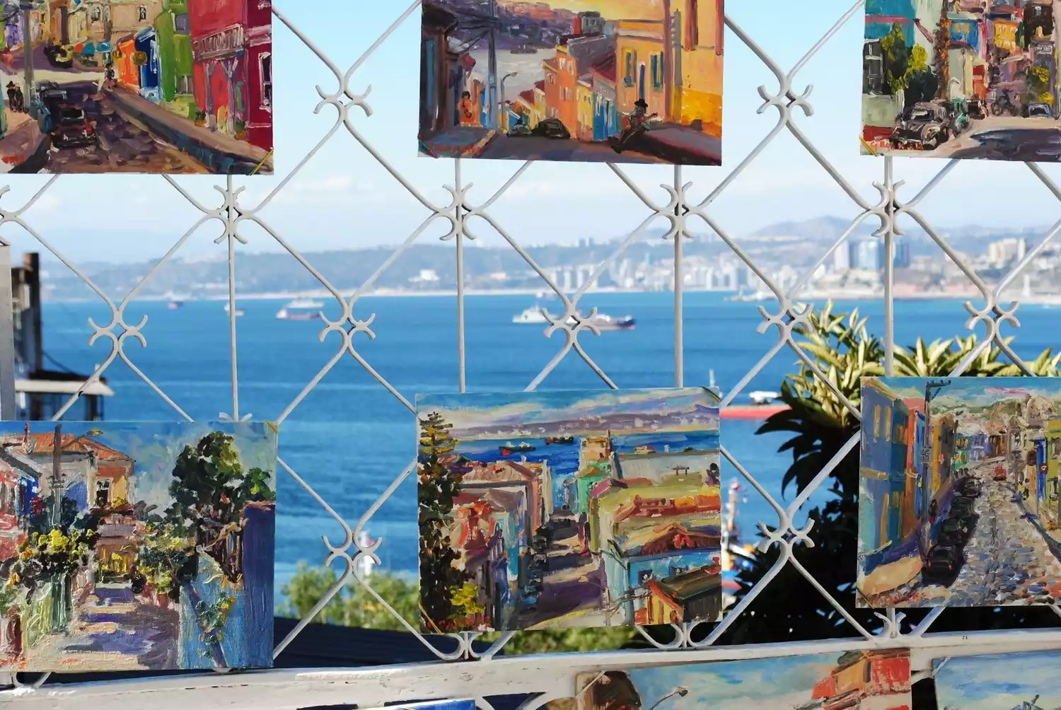
The two neighborhoods of Cerro Alegre and Cerro Concepción are representatives of Valparaiso's bohemian culture. Both are located on slightly higher hills and are home to unique buildings, historical sites, restaurants, bars and handicraft shops, with distant sea views.
/Art Museum/
Palacio Baburizza was built in 1916 and is located on the landscaped block of Cerro Alegre. It was converted into the Museum of Art (Museo de Bellas Artes) in 1972, which houses a collection of European paintings from 1840 to 1930 and works by Chilean artists after 1844.
If you are tired of visiting, you can stand in front of the window and admire the view of Valparaiso against the backdrop of the sea.
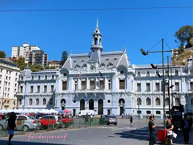
/Naval Museum/
The Naval Museum (Museo Naval y Marítimo) is a museum dedicated to the Chilean Navy and its ships. It showcases the glorious history of Chile's victories in wars against Peru and Bolivia in the 19th century. It houses over 3,000 exhibits and over 30,000 books and documents, making it a must-see for military history enthusiasts.
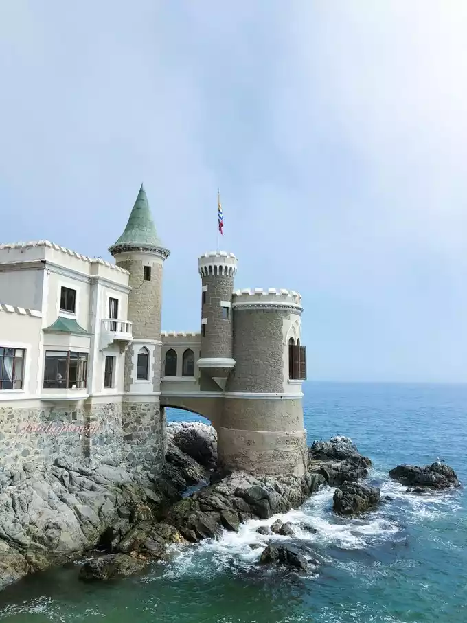
/Wolf Castle/
In the early 20th century, a Valparaiso businessman built the German fairy-tale-style Wolf Castle (Castillo Wulf). The castle stands on the rocks on the seashore. Its beautiful and elegant appearance is a highlight of Viña del Mar.
Now the first floor of the castle has been transformed into an exhibition center, displaying some contemporary art works, and most of the interior areas are not open to the public.
/Chilean Cuisine/
Chilean cuisine is a fusion of the culinary characteristics of Spanish and Mapuche cultures. The northern cuisine is more inclined to the Andean plateau flavors of Peru and Bolivia; the coastal areas are mainly seafood; and the south has a lot of barbecue, which is also influenced by the culinary culture of German, Italian and French immigrants.
Chilean Platter (Chorillana):
This regional specialty is incredibly generous. A large plate is topped with French fries, a large grilled steak or pork chop, a sprinkle of fried onions, and finally a fried egg, sometimes with sausage. This dish is so filling that even a small appetite can easily be shared between two women.
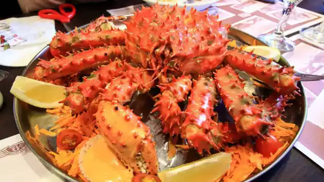
Chilean King Crab (Centolla):
Chilean king crab, a species found along the South Pacific coast of Chile, Peru, and other countries, is large and delicious, yet significantly more expensive than other seafood. Chilean king crab can be eaten raw, steamed, or its meat can be used in dishes like tortellini. However, to protect this species, there's a long annual fishing moratorium: fresh Chilean king crab is only available from July 1st to November 30th. Otherwise, it's only available in canned or frozen form.
Empanada
Grilled or fried, they are large and cheap, with prices ranging from 600 to 1500 pesos, and are filled with cheese, beef, chicken, seafood, etc. Chile has a unique filling called Pino, which is made with beef, onions, eggs and black olives, and tastes good.
Corn Pastel (Pastel de Choclo):
A South American specialty, choclo corn (a South American corn) is placed on a deep plate and grilled. This can also be topped with potatoes (papa), creating a pastel de papa. Cazuela: Similar to Northeastern hotpot, it's typically a stew of meat, potatoes, and pumpkin. Sometimes, it also includes rice, shredded noodles, green beans, carrots, and celery. The authentic way to eat it is to drink the smaller ingredients with the broth first, then eat the meat and larger vegetables.
Fried Milk (Leche Frita):
This Chilean dessert, resembling a rice cake, is influenced by European cuisine. Made with milk, sugar, lemon zest, and flour, it's cooked until firm and then deep-fried. It's then sprinkled with powdered sugar and cinnamon.
Pisco:
A strong alcoholic beverage produced in Chile and Peru, distilled from wine, typically around 40% alcohol. High-quality versions can be enjoyed on their own, while lesser-quality versions are used in cocktails. A Pisco Sour is made by mixing Pisco with lime juice, sugar, and ice. Both Peru and Chile claim to have invented this cocktail. Pisco can also be substituted with other fruit-flavored syrups or juices.
tip
A 10% tip is customary in Chilean restaurants, with the exception of fast food restaurants and particularly inexpensive street vendors. Tips are tax-free and considered the server's personal income, so they don't appear on the bill. If you're unsure whether a tip is expected, ask before dining.
Argentina - the proud yet lost country of aristocratic silver
Argentinacheck the details
Argentina is located in southern South America, bordered by the Andes Mountains with Chile, Bolivia and Paraguay to the north, Brazil to the northeast, Uruguay and the South Atlantic Ocean to the east, and the Drake Passage to the south. Its land borders total 9,376 kilometers, and its maritime border with the Atlantic Ocean at the mouth of the Río de la Plata is 5,117 kilometers long. Argentina's highest point is Mount Aconcagua in Mendoza Province, at 6,959 meters, the highest point in both the Southern and Western Hemispheres. Its lowest point is the Charcoal Lake in the San Julián Depression in Santa Cruz Province, at 105 meters below sea level, the lowest point in both the Southern and Western Hemispheres and the seventh lowest point in the world. The main rivers are the Paraná, Uruguay (which flows into the Río de la Plata), Paraguay, Salado, Negro, Santa Cruz, Pico Mayo, Bermejo, and Colorado rivers. These rivers ultimately drain into the Argentine Sea, a shallow sea situated on the vast Argentine continental shelf. The two main ocean currents that influence these waters are the Brazil Current and the Falkland Current.
Recommended months: Summer and winter are the best
9968 recommendations, 7897 visits
Argentina has a vast territory, bordering the Atlantic Ocean to the east and the Antarctic to the south. In the center, there are endless Pampas grasslands, the Andes Mountains to the west are covered with snow all year round, and the desert highlands block the north. The combination of various climates and landscapes has created a diverse appearance in the country, which is worth careful appreciation.
Argentina has the highest and lowest points in both the Southern Hemisphere and the Western Hemisphere. The highest point is Mount Aconcagua in the Andes Mountains in Mendoza Province, at an altitude of 6,959 meters, and the lowest point is the Charcoal Lake in the San Julian Depression in Santa Cruz Province, 105 meters below sea level.
"Argentina" means "silver" in Latin. The La Plata River, formed by the confluence of Argentina's largest rivers, the Paraná River and the Uruguay River, is also the "Silver River" in Spanish. The word "silver" is very appropriate to match the rushing Iguazu Falls, the glaciers in the west, and the white waves in the strait.
Wong Kar-wai chose Argentina to shoot Happy Together, probably because it seems like the end of the world. However, beyond the camera lens, there are also modern tango, surging straits, and ten-thousand-year-old glaciers.
Buenos Aires - Pleasant Air
Buenos Aires is the capital of Argentina. It is a city built by Europeans. Just like the Spanish translation of "Buenos Aires" which means "fresh air", this city has a pleasant climate all year round and is full of vitality and artistic atmosphere. It is known as the "Paris of South America".
The layout structure of the entire city is very clear. Each street runs east-west or north-south, and each block is roughly 100 meters long and 100 meters wide, so the distance between two places can be calculated based on the house number.
Like some other large immigrant cities, Buenos Aires has diverse cultures and elements, but it also maintains its own inherent characteristics, inheriting the elegance and nobility of European culture and integrating the unrestrained and passionate Latin American culture.
Among the more than 40 barrios in Buenos Aires, each barrio has its own characteristics.
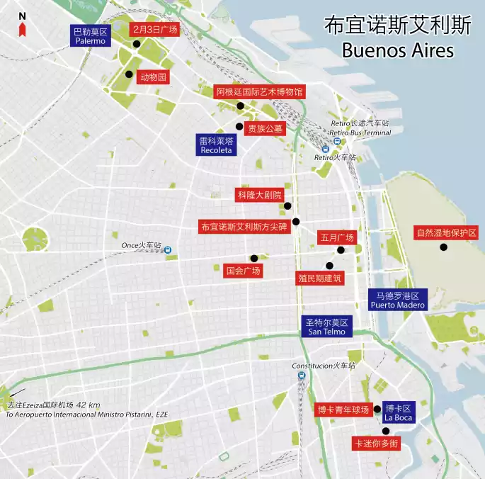
/Recoleta/
This is an area with both modern atmosphere and historical culture. It is filled with brand boutiques, various theaters, cinemas, high-end restaurants and parks. It also has ancient European buildings and roads, and historical cultural heritage. The famous "Cementerio de Chacarita" cemetery is here.
/San Telmo/
Various flea markets, where you can find many antique shops and local handicraft shops, such as silver jewelry.
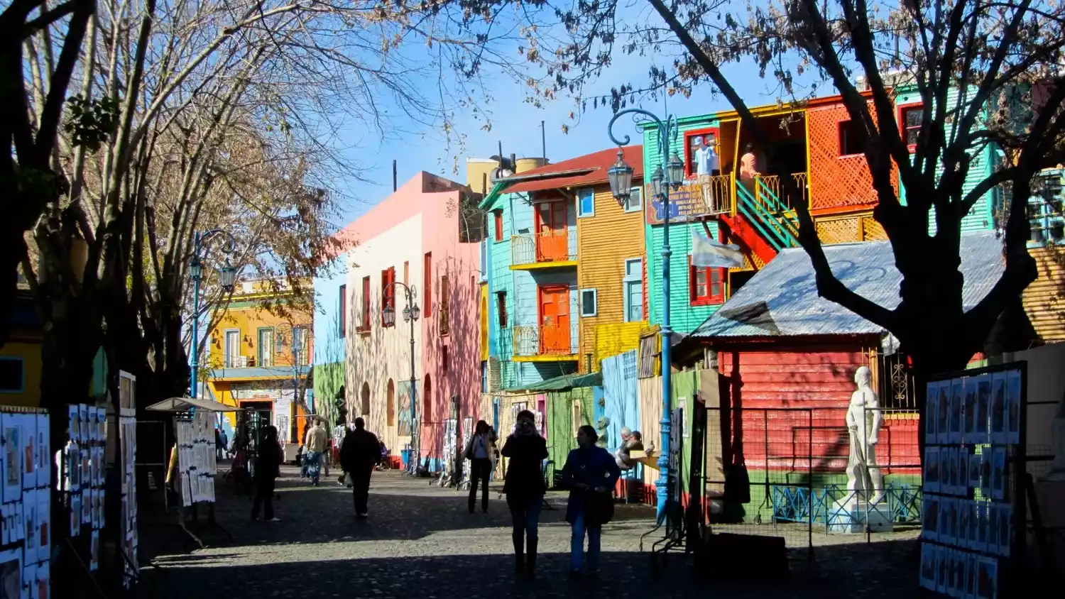
/La Boca/
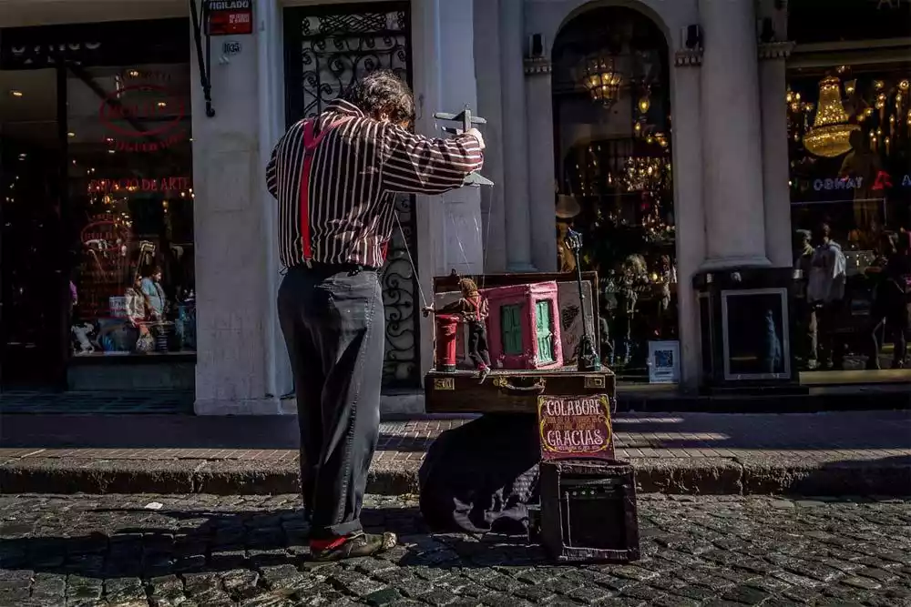
The most famous area in this district is the Caminito neighborhood, which represents tango culture and has tango performances, tango museums, tango culture introductions, etc.
El Caminito Street is the main attraction in the Boca district and the place where the most tourists gather. The colorful buildings and artistic graffiti on the walls can be seen everywhere, the melodious and sexy tango music, street art performances and various art and craft exhibitions have attracted the attention of many tourists.
However, because there are many tourists and it is a slum area, it is best to go there during the day. There are many thieves at night and it is not safe.
/Palermo District/
Palermo is where most of the middle class live. With its wide streets and zoo, it is the perfect place for family leisure, picnics and sports on weekends.
In addition to leisure and entertainment, this area is also a center for dining. You can find a variety of Latin American cuisine, including Peruvian, Chilean, Brazilian, and Mexican cuisine, as well as Asian restaurants such as Japanese and Vietnamese.

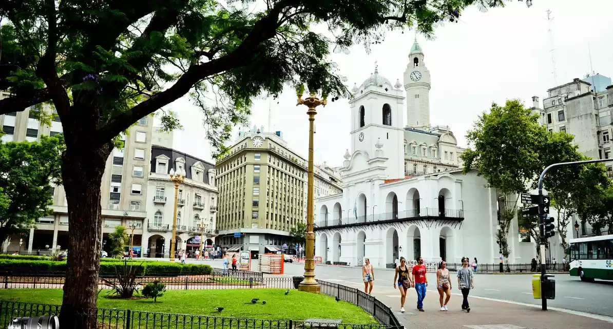
/ Plaza de Mayo/
Built in 1580, Plaza de Mayo, formerly known as the Grand Plaza and Victory Plaza, has etched a legacy of centuries of Argentine history and political movements. A symbol of Argentina, it has witnessed the independence of the Argentine Republic and the city's development.
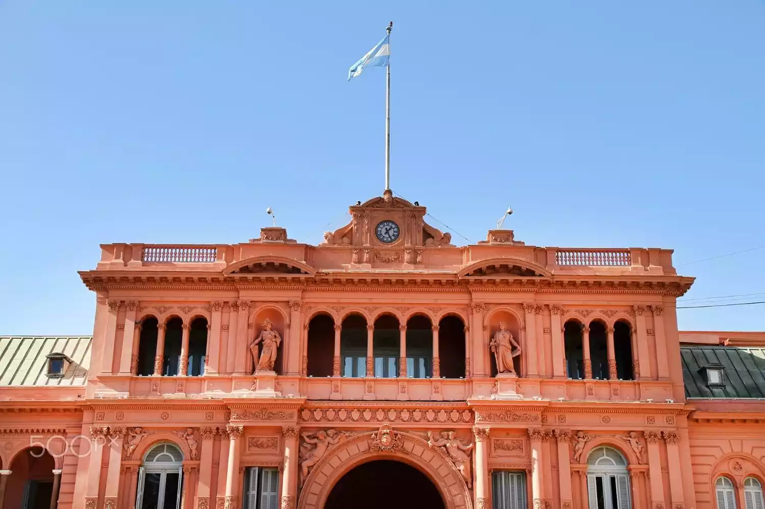
/Place Rose/
The Casa Rosada, the presidential palace, is a Spanish-style rose-colored building located on the east side of Plaza de Mayo. The president works and holds meetings here from Monday to Friday. It is open to the public free of charge on weekends. English-language guided tours are available at 2:30 p.m. on Saturdays, Sundays, and holidays, and include the president's private elevator and office.
Tips:
Visitors must make reservations in advance online (visitas.casarosada.gob.ar), and reservations can be made at least 15 days in advance.
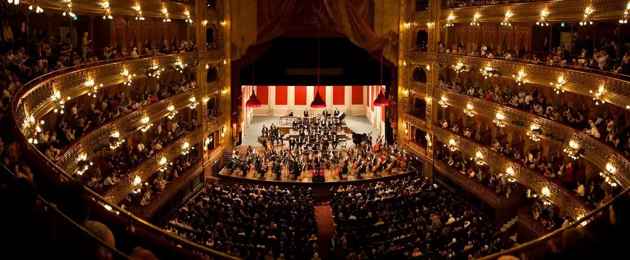
/Cologne Theatre/
Located on Calle 9 de Julio in Buenos Aires, the Teatro Colón is one of the world's three most famous theaters, seating 2,500 and 500 standing rooms. The seats are spacious and comfortable, and the acoustics are superb.
The performance season starts in March every year and lasts until the end of winter. World-class theater and ballet companies as well as famous singers, pianists, ballet masters and opera stars will perform here during the performance period.
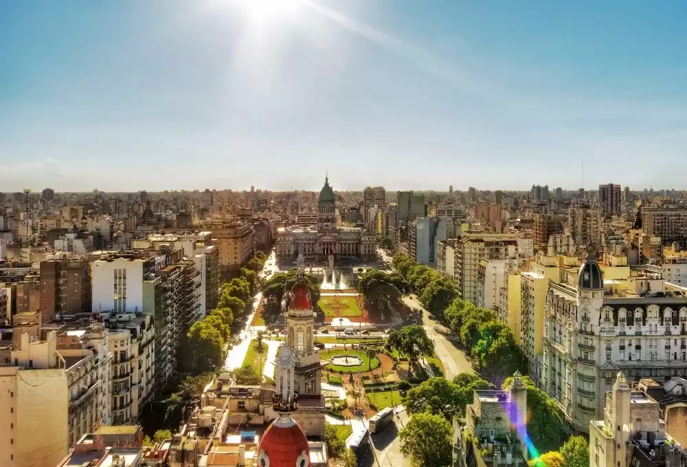
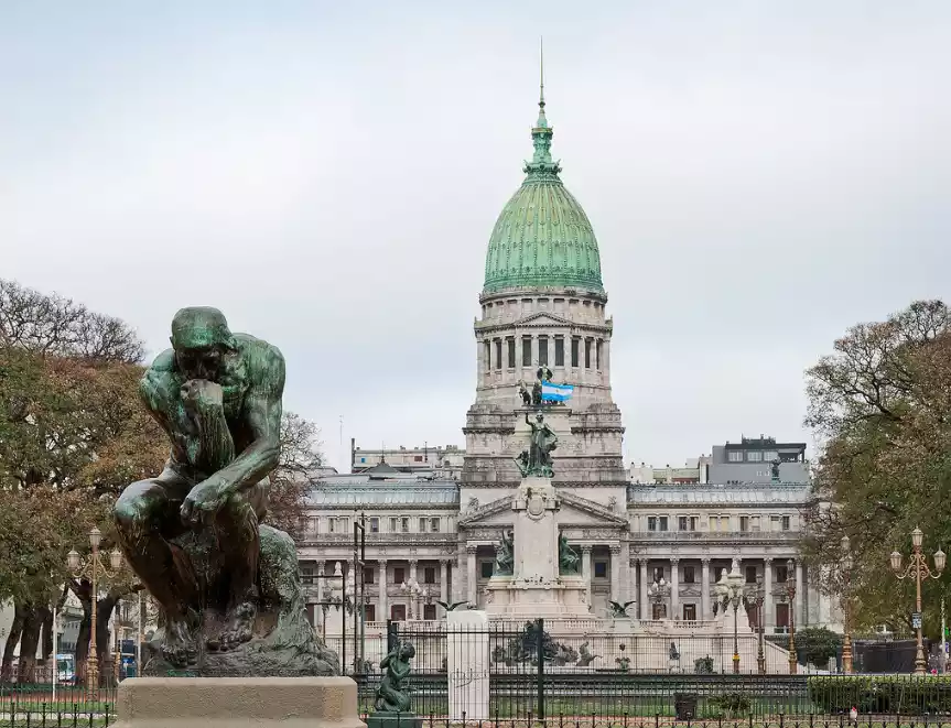
/Capitol Square/
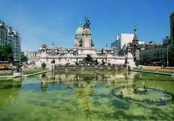
Walking west from Plaza de Mayo along Avenida de Mayo to its end, you'll find the city's largest square, Plaza del Congreso. The square boasts monuments to two famous congresses (the 1813 Constituent Assembly and the 1816 Congress), and the National Congress Building (Palacio del Congreso) is at its western end.
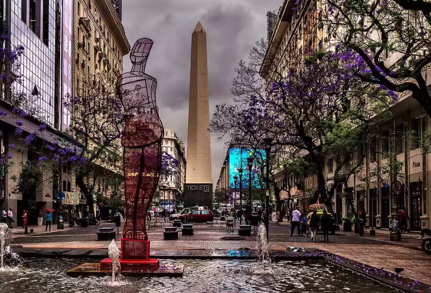
/The Obelisk of Buenos Aires/
The Obelisk of Buenos Aires is a Buenos Aires landmark, located in the Plaza de la República at the intersection of Corrientes and 9 de Julio Avenues. Designed by architect Alberto Prebisch in 1936 to celebrate the city's 400th anniversary, the 67.5-meter-tall obelisk was built.
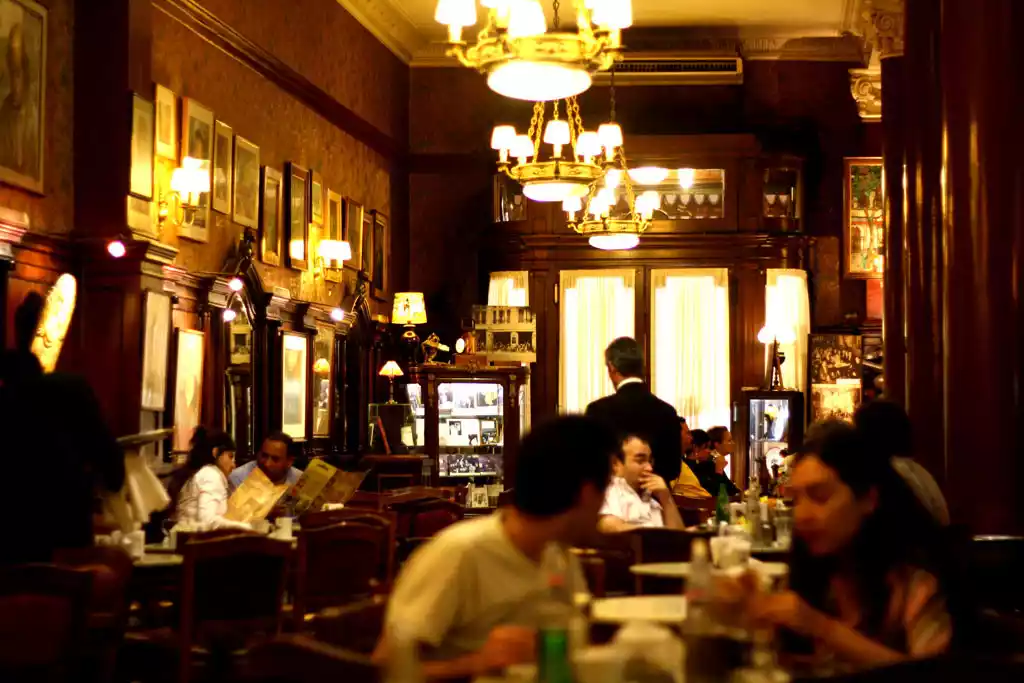
/cafes/
Due to the influence of the Spanish and Italian immigration waves, coffee culture has been deeply rooted in the lives of Argentines. The coffee shops here are open from morning until the early morning, and any time period is coffee time.
Common types of coffee include the following: the most common Café con Leche (half coffee, half milk), Café Cortado (espresso with a few drops of milk), Café Lágrima (whole milk with a few drops of coffee), Capuchino (cappuccino), etc., all of which taste very authentic.
Coffee is usually paired with Medialunes (croissants), Alfajor (similar to chocolate pie, with various flavors, a dessert unique to Latin America) and Tarta (various dessert cakes).
Recommended cafe: Tortoni Café (oldest)
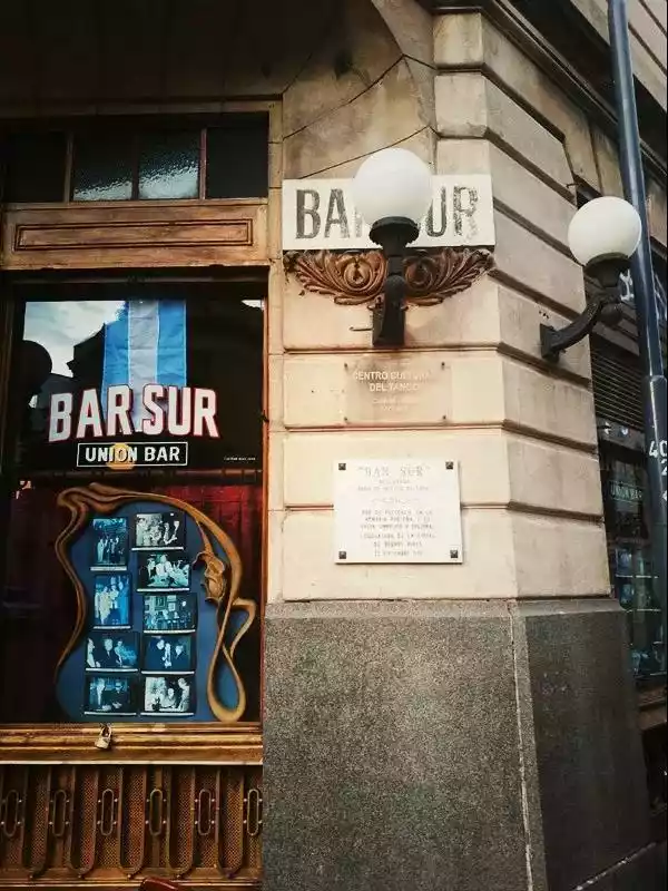
bar
Buenos Aires has a very rich nightlife. The nightlife begins after 10 pm and the bars are very lively. Among them, Bar Sur is the bar where Leslie Cheung and Tony Leung had a love-hate relationship in Happy Together. The English name of this movie is Happy Together, and there are also souvenirs of this movie in the bar.

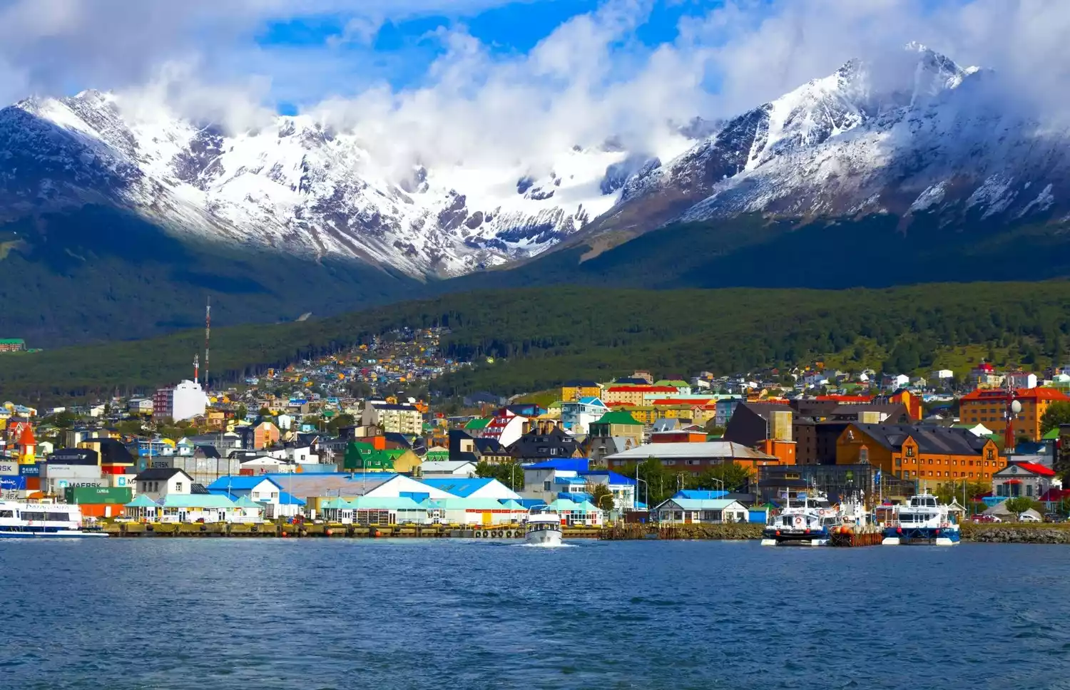
Ushuaia - The End of the World
Ushuaia, the capital and administrative center of Argentina's Tierra del Fuego Province, was founded in 1893. Nestled against the Andes Mountains and overlooking the Beagle Channel, it is known as the "city at the end of the world" and the "gateway to Antarctica." Ushuaia is a vibrant and bustling city filled with artistic flair.
The city image of Ushuaia is that of snow-capped mountains with colorful cabins lined up on the coast. The pace of life is as quiet and slow as in most Latin American cities.
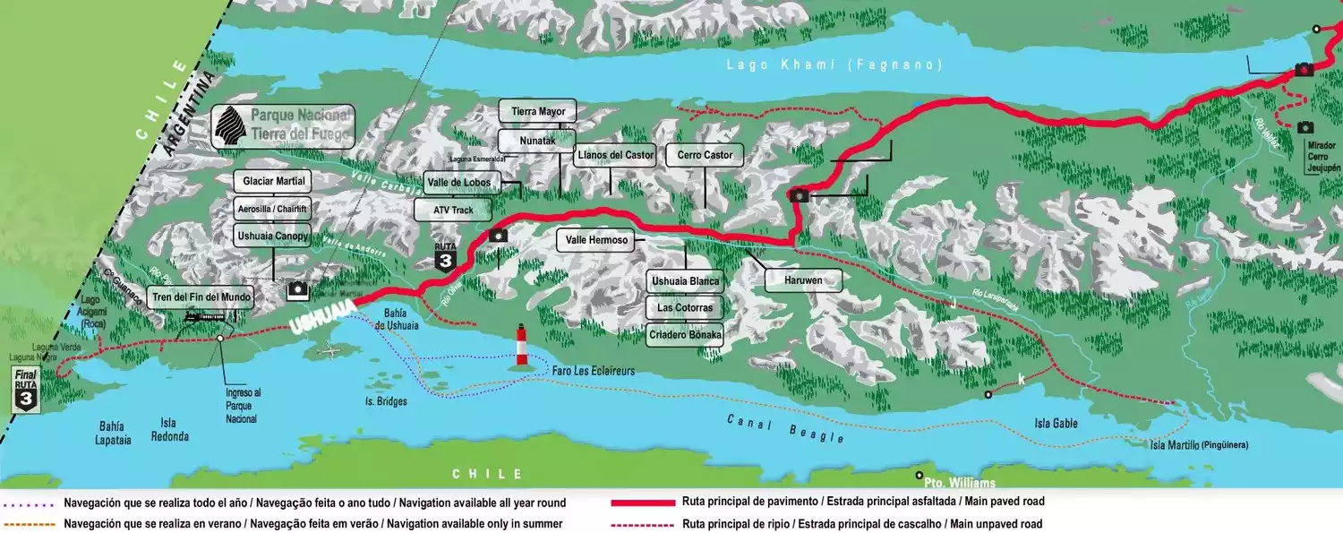
Tierra del Fuego National Park
Tierra del Fuego National Park was established in 1960. It is located at the southwestern tip of Tierra del Fuego, bordering the Beagle Channel and the city of Ushuaia. It covers an area of 68,909 hectares and belongs to the Patagonian Forest Ecological Zone.
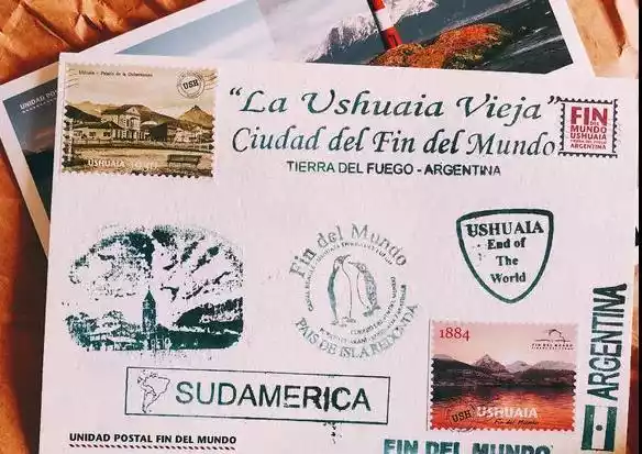
The park is famous for its beautiful glacial lakes, pristine forests, waterfalls, streams and coastal scenery. The main attractions include Lapataia Bay, Black Lake, Rock Lake, Piper Lake Waterfall and Ensenada Bay. Among them, the "Post Office at the End of the World" (Unidad Postal Fin del Mundo) is located in Ensenada Bay.
For travelers who are visiting Tierra del Fuego National Park for the first time, it is recommended to choose the "train + car" tour method, which allows you to go to more places in a limited time, and the guide's explanation will also make the natural scenery more meaningful.
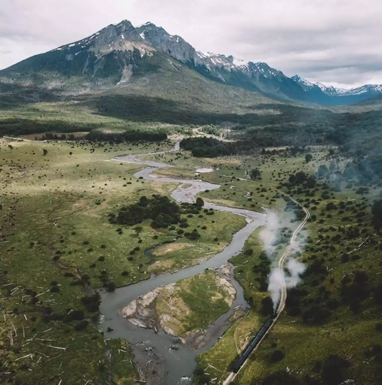
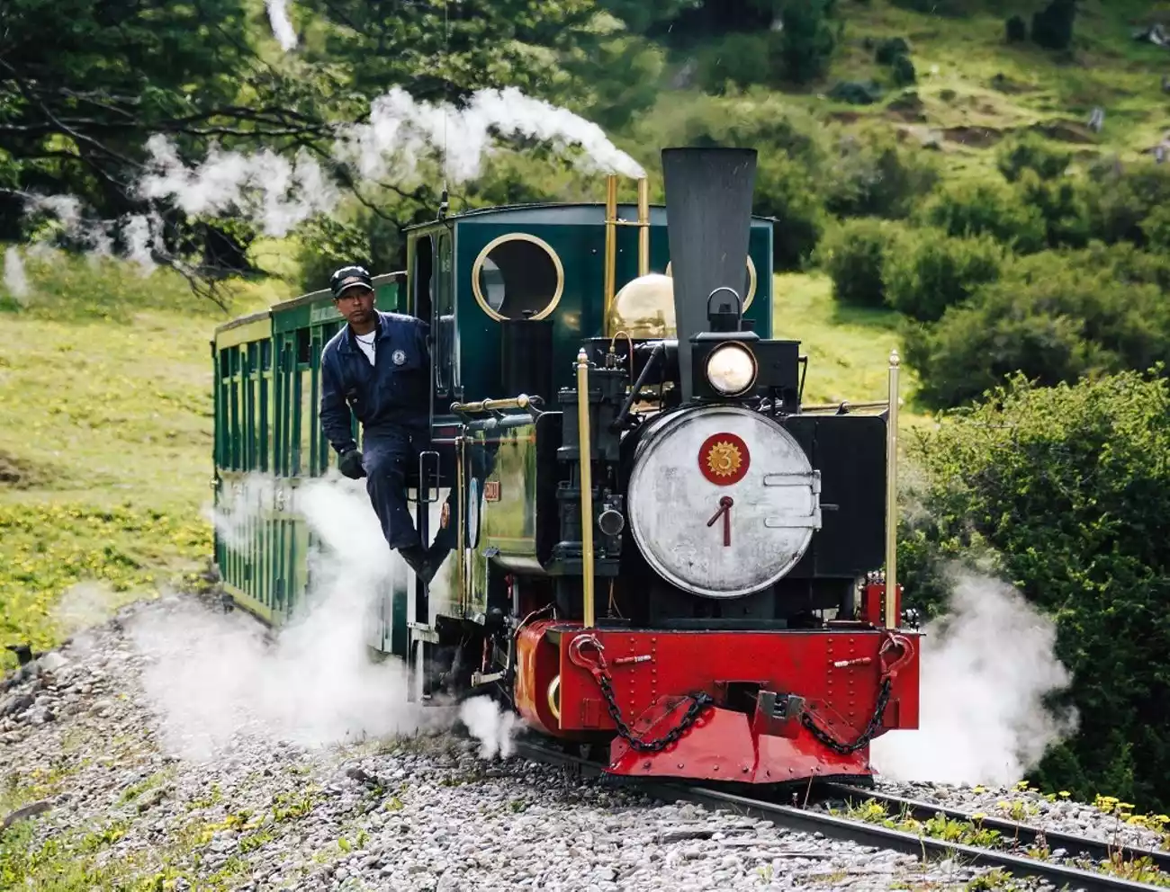
/Tren del Fin del Mundo, the train at the end of the world/
Built in the late 19th century by prisoners from Ushuaia Prison, it's known as the "Convict Train" and is the closest train to Antarctica. The 25-kilometer line is currently open to the public for the final 7 kilometers. The scenery along the way is breathtaking, with stops at several small stations offering 15-minute tours. A Chinese-language brochure is available at the station.
Tips:
Departure time:
Peak season (September 1 to April 30): 9:30, 12:00, 15:00;
Off-season (May 1st to August 31st): 10:00, 12:30, 15:00
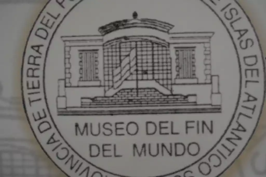
/Museo del Fin del Mundo/
The museum has two locations. The Traditional Building, formerly the National Bank, is one of Ushuaia's iconic brick buildings. The New Building, formerly the House of Government and Parliament, houses four traditional exhibition halls and a multimedia exhibition hall. Temporary thematic exhibitions are also held in the New Building.
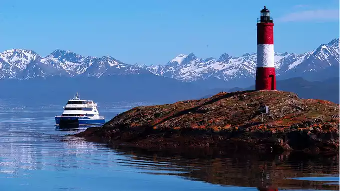
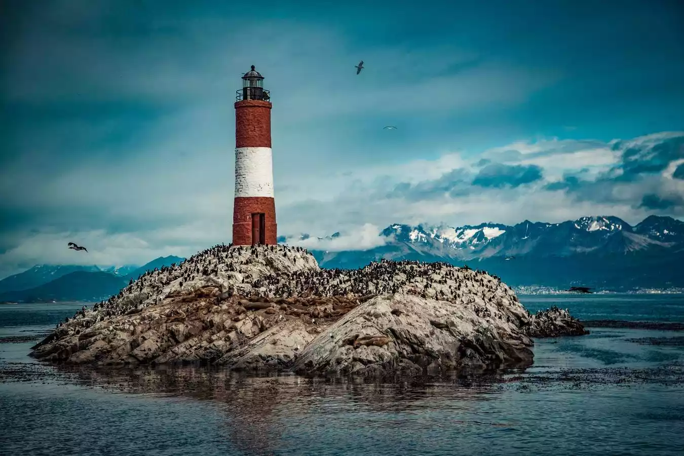
/The Lighthouse at the End of the World/
The "lighthouse at the end of the world" mentioned in "Happy Together" is the iconic red and white building "Les Eclaireurs", a classic attraction for visiting the Beagle Channel.
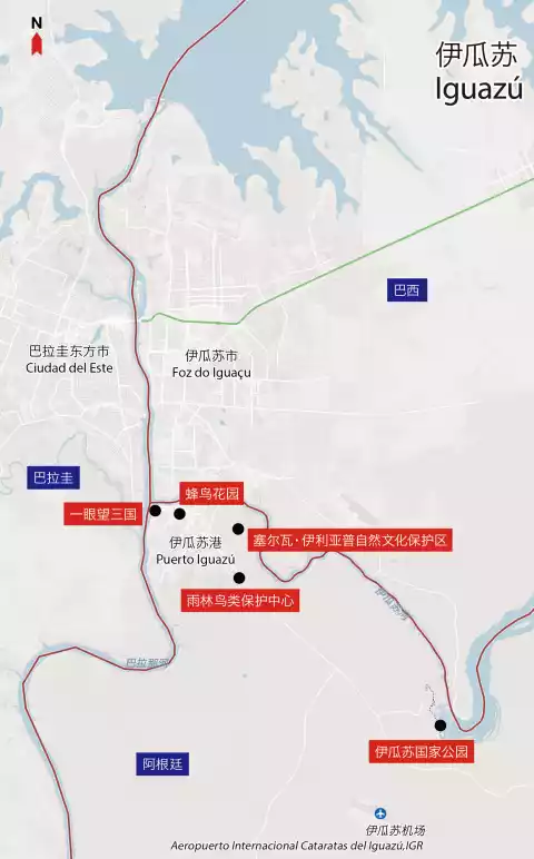
Iguazu Falls - the world's widest waterfall
Iguazú Falls is one of the world's largest and widest waterfalls. Its name comes from the Guarani language, meaning "great water." The Iguazú Falls sit on the border between Brazil and Argentina, with the Brazilian portion accounting for 20% of the area and the Argentinian portion for 80%. Both countries have established Iguazú National Parks. The Argentinian portion (Puerto Iguazú) was designated a UNESCO World Heritage Site in 1984, and the Brazilian portion (Foz do Iguaçu) was added in 1986.
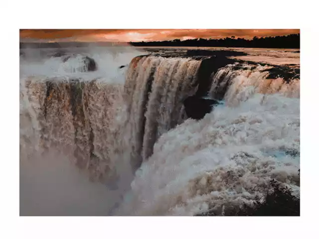
There are 275 waterfalls of various sizes, with the largest drop reaching 90 meters. The most spectacular waterfall is the U-shaped "Devil's Throat" (Garganta del Diablo), which is 82 meters high, 150 meters wide and 700 meters long. You can walk up to the waterfall along the plank road in Iguazu National Park in Argentina, which is very shocking.
Tips:
It is recommended to start visiting the waterfalls in Brazil, enjoy the panoramic view, and then go to Argentina for a closer look, from large to small, from far to near.
In Iguazu National Park, you can also observe the flora and fauna of the rainforest area up close, including more than 450 species of birds, monkeys, coatis, deer, foxes, lizards and other animals.
There are many trails in the park. The Upper Circuit, Lower Circuit and Devil's Throat are the must-see routes to visit the waterfalls; the Green Trail has the same destination as the park's train, and you can choose to take the train or hike along the trail; and the Macuco Trail is a longer route that goes deep into the rainforest.
In addition to walking tours, the park also operates a 3.7-kilometer train. The train has three stops: the Central Train Station at the park entrance, the Cataratas Train Station midway, and the Devil's Throat Train Station, the final stop. The journeys take 10 and 15 minutes, respectively.
Each train station is equipped with restrooms, a simple restaurant, and a small shop. The park's management is generally poor, and even with large crowds, train frequency is often not increased, often leading to long waits. The first two stations are connected by a walking trail. If the lines at the train station are long, travelers with good stamina and ample time are recommended to hike. This allows visitors to see the unique rainforest flora and fauna while also avoiding the wait.
Brazil - a country of natural enthusiasm and innocence
Brazilcheck the details
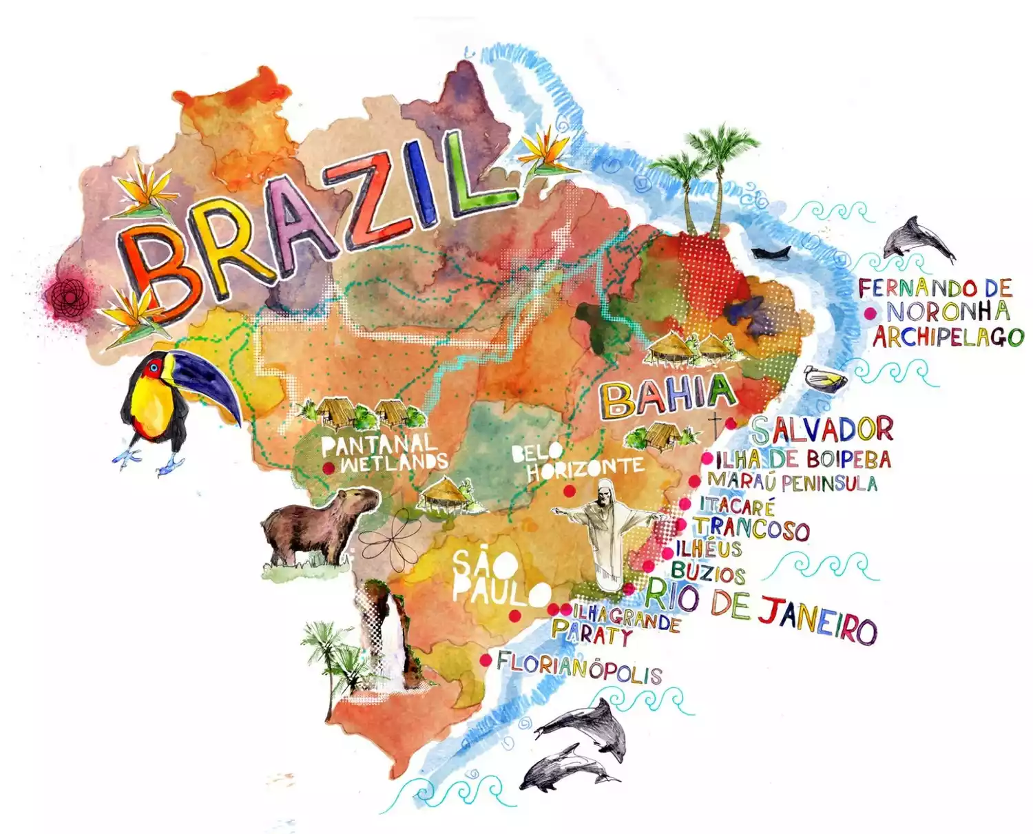
The Federative Republic of Brazil is the largest country in Latin America, with a population of just over 200 million, the fifth largest in the world. Brazil boasts vast farmlands and extensive rainforests, and its name derives from the Brazilian rosewood. Thanks to its abundant natural resources and abundant labor force, Brazil's GDP ranks first in South America, sixth in the world, third in the Western Hemisphere, and first in the Southern Hemisphere. It is a member of the Union of South American Nations (UNAM). Due to its historical status as a Portuguese colony, Brazilian Portuguese is the official language. The vast Amazon rainforest covers the northern part of Brazil, while the hilly southern region, home to the majority of the population, is an agricultural base. Several mountain ranges line the Atlantic coast, reaching as high as 2,900 meters. Mount Nebrina on the northern Guiana Plateau is the highest point in the country at 3,014 meters. The Amazon River, flowing through Brazil, is the world's largest river by volume. The Paraná River is the second largest river in South America, and the famous Iguazú Falls are located on its tributary. The climate is tropical across most of the country, with the Amazon Plain experiencing an equatorial rainy climate, the plateau experiencing a tropical wet and dry season, and the southernmost region experiencing a subtropical humid climate with occasional frost and snow. The Amazon Plain receives abundant rainfall, while the northeastern region is slightly drier.
Recommended months: Spring and autumn are the best
8911 recommendations, 7655 visits
Brazil is the largest country in South America, with many ethnic groups. It is also famous for its many festivals, which reflect the people's enthusiastic and fun-loving personality.
Brazil is blessed with unique climate and nature, with pleasant weather all year round, suitable for the growth of various animals and plants. It has the world's largest Amazon River and the mysterious rainforest in its basin, which contains endless treasures.
Residents of Brazil's big cities love shopping malls very much. Big cities like Rio and São Paulo have dozens of shopping malls of all sizes. In comparison, life for residents living in small cities is much simpler.
Rio - City of God, Demons and Angels
Rio de Janeiro means "River of January" in Portuguese. While it's more commonly known as "Rio," it also has a more resonant nickname: "City of God."

There are also many popular works here, such as "Rio", "City of God", and "The Girl from Ipanema". The domestic travel program "Flowers and Youth" Adventure Season is no exception and chose Rio for an exciting adventure.
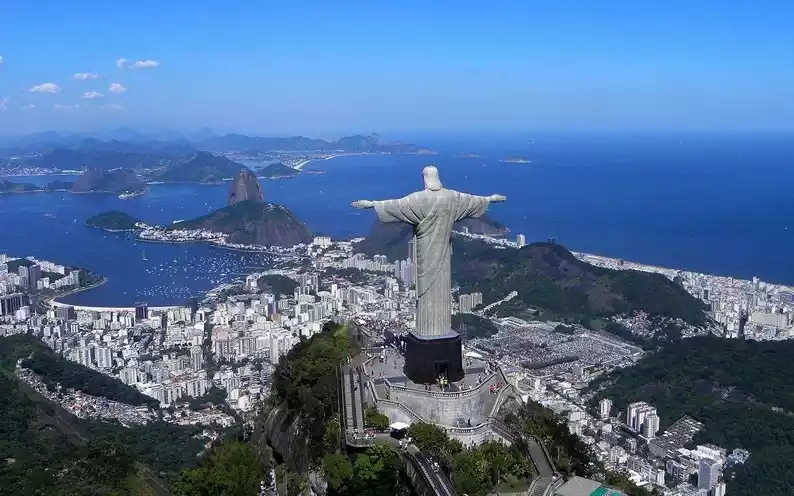
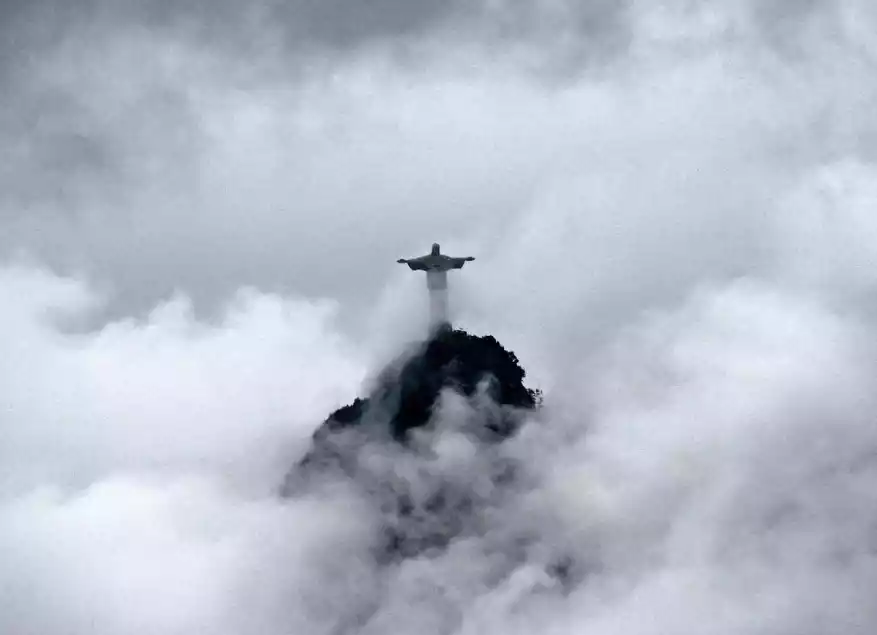
/Monte Cristo/
Corcovado is a symbol of Rio de Janeiro and Brazil, and was named one of the New Seven Wonders of the World in 2007. The Christ the Redentor statue stands 38 meters tall and weighs 1,145 tons, standing with its arms outstretched atop the 710-meter-high Corcovado.
After nightfall, the Christ the Redeemer statue is illuminated by lights and can be seen from almost every corner of the city. It looks like a huge white cross suspended in the air, guarding Rio de Janeiro.
Tips:
From Cosme Velho at the foot of Monte Cristo, you can take the scenic area bus, taxi, walk or take the sightseeing train to the top of the mountain.
The train runs from 8:00 to 19:00, with one train every half hour. Sometimes the ticket queue may take more than half an hour, and the journey takes 20 minutes.
We recommend reaching the summit before 9:30 AM, when there are fewer tourists and the peak is less crowded. Monte Cristo also faces east, so taking photos in the morning won't be backlit. Alternatively, you can take a dedicated minibus from Copacabana Beach. The fare is 61 reais in the off-season and 74 reais in the high season.
Sightseeing train station address: Rua Cosme Velho 513, Cosme Velho
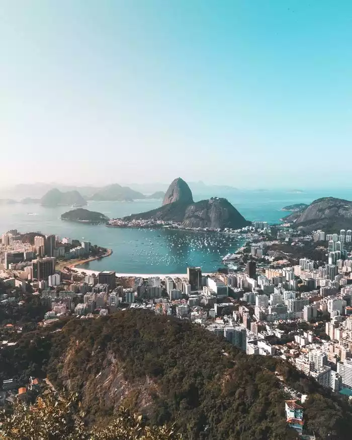
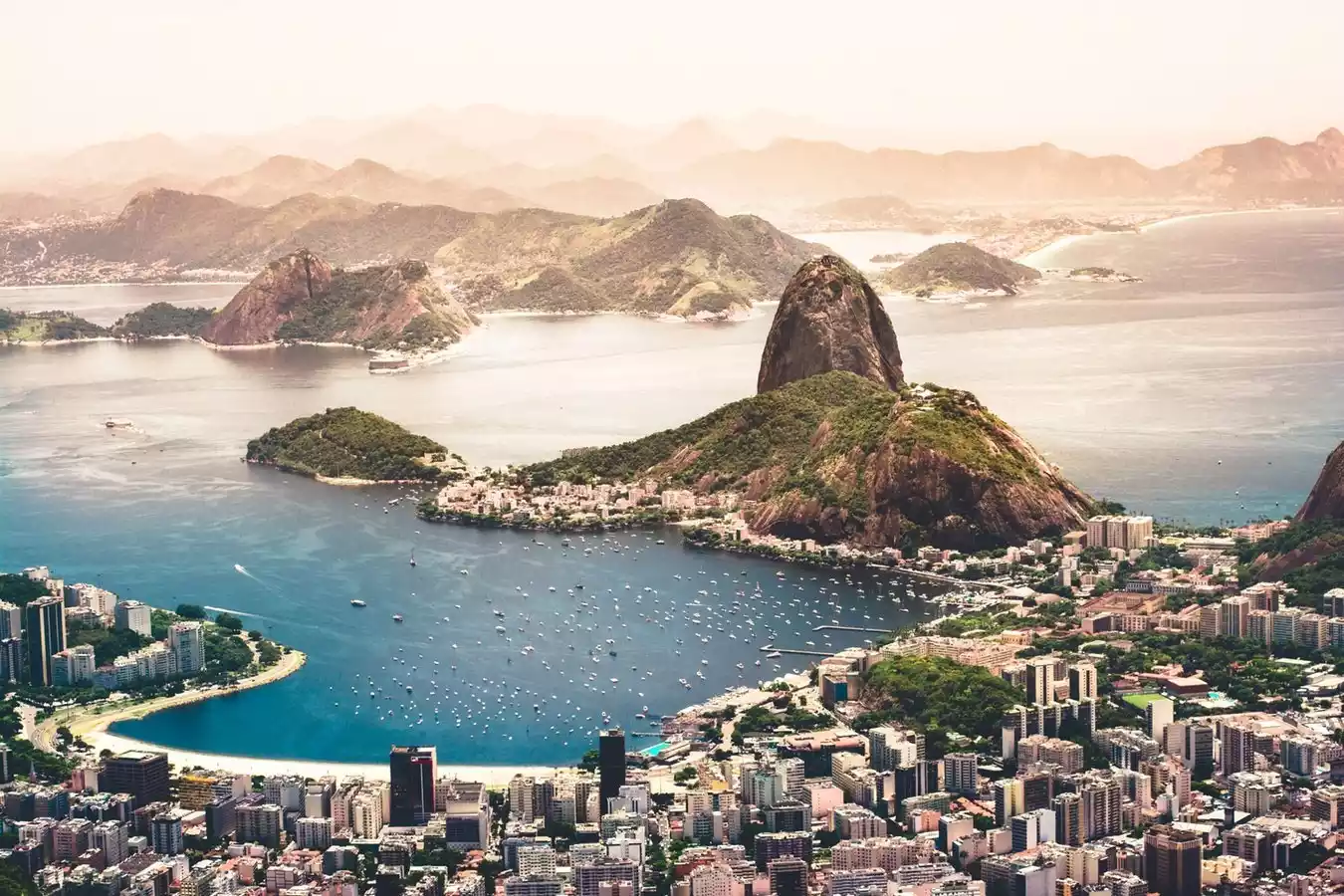
/Bread Mountain/
Sugar Loaf Mountain (Pão de Açúcar), 396 meters above sea level, stands on a peninsula. The view of the city from the top of the sea is very broad. From the top of the mountain, you can see Monte Cristo, Rodrigo Atoll and Copacabana Beach in the distance.
Tips:
How to get there:
There are two cable cars from the foot of the mountain to the top. One goes from Praça Vermelha to Morro da Urca, and the second cable car goes from Urca across the bay to the top of Bread Mountain. The cable cars run every 20 minutes.
Opening hours: 8:00-19:50, the ticket office closes one hour in advance.
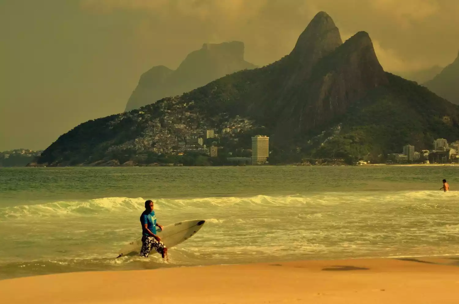
/Ipanema Beach/
Rio de Janeiro's most beautiful scenery lies on its beaches. Of Rio's 17 beaches, the most famous are undoubtedly Ipanema and Copacabana. Ipanema gained international fame in the 1960s as a hub for the Bossa Nova dance movement, spawning the famous song "The Girl from Ipanema."
The beach is always crowded with people of all colors enjoying the sea and sunshine. On clear days, you can watch a stunning sunset from Aropoador, a reef that separates Ipanema Beach and Copacabana Beach to the east.
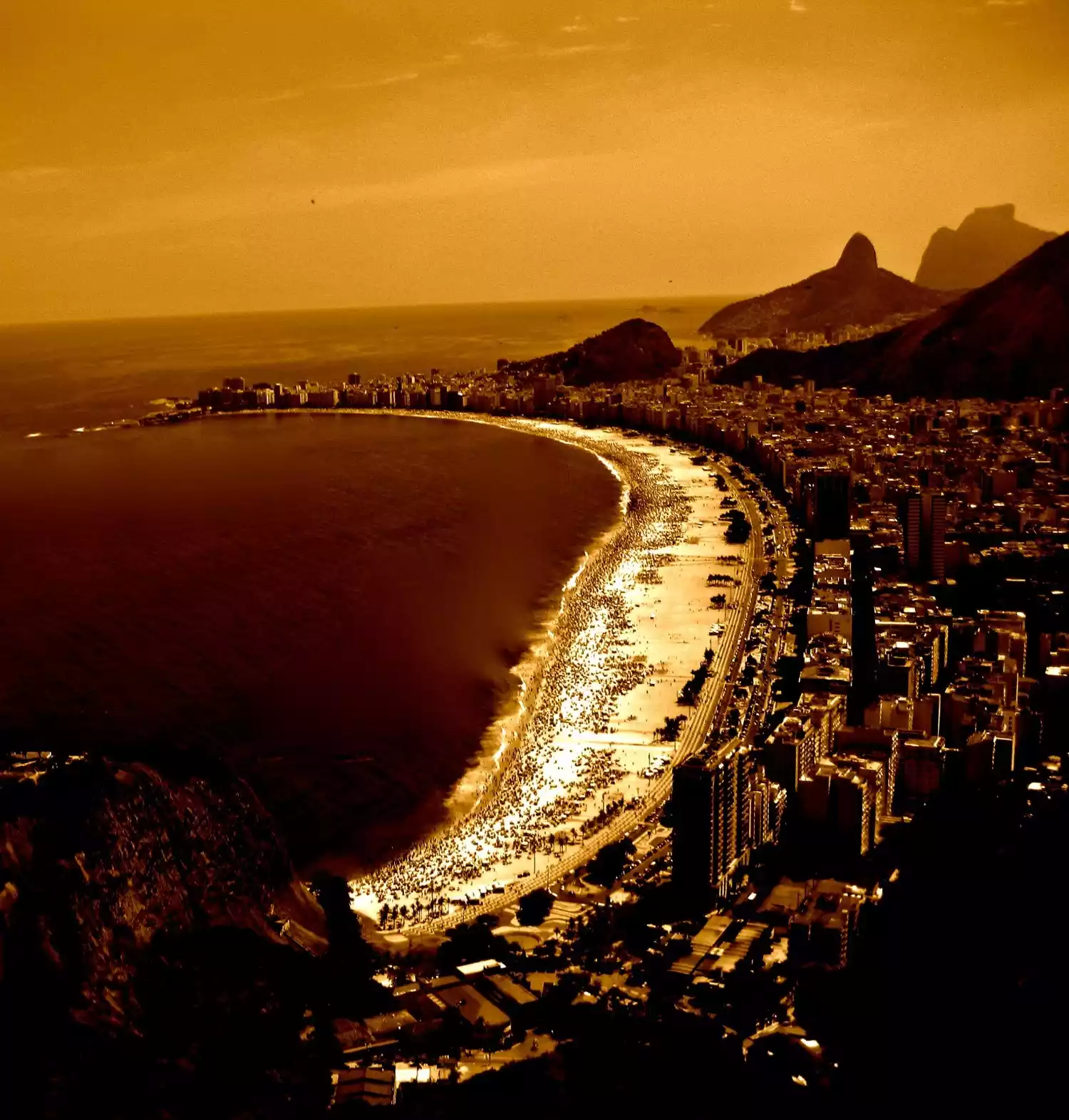
/Copacobana Beach/
Copacabana Beach (Praia Copacabana), located east of Ipanema Beach, is a 4.5-kilometer-long beach and a popular destination for Rio residents. It's dotted with hotels, cafes, and kiosks selling snacks and drinks. However, be aware that security at Copacabana Beach can be quite dangerous at night, so avoid staying too late.
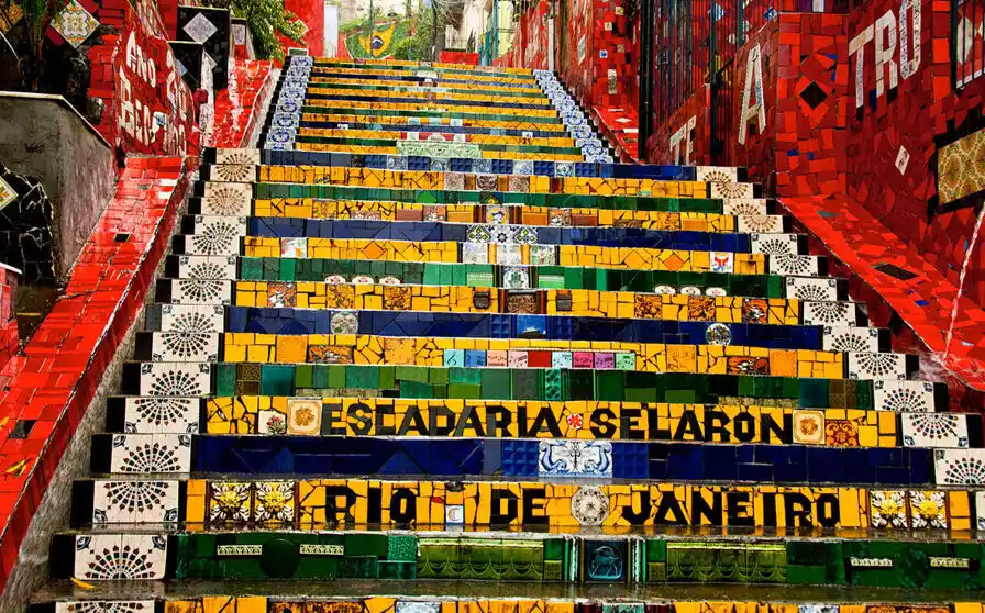
/Selron Steps/
Selron was a Brazilian painter and ceramic artist who lived next to the staircase at the time. He collected different tiles from all over the world and received donations from friends around the world. It took him 20 years to complete the transformation of this famous colorful staircase.
/Rodrigues Atoll/
Lagoa Rodrigo de Freitas, often referred to as "Lagoa," is a vast expanse of water connected to the Atlantic Ocean north of the Ipanema district. It's known to Rio natives as "the heart of Rio." The area is inhabited by both the middle class and the wealthy, and at Christmastime, a giant floating Christmas tree is displayed on the water.
You can often see people doing water sports such as kayaking on the calm water. There is a 7.5-kilometer bicycle path winding along the lake, and some marine events of the 2016 Olympic Games will be held here.
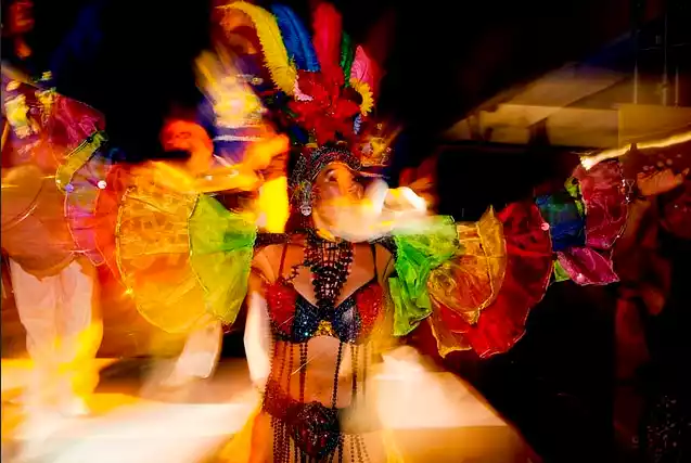
/Samba Party/
Brazilian samba parties run throughout the year, and Rio's most authentic street samba parties are concentrated on the streets of Lapa.
You don't need to go to a nightclub; on weekends, samba bands spontaneously perform under the white Arcos da Lapa. Cariocas and tourists dance to the powerful beats, and locals will teach you the steps. Be wary of children playing soccer nearby; they sometimes cause chaos by charging into the crowd, and their accomplices may even snatch necklaces and earrings from tourists.
If you're looking for a nightclub, follow Av. Mem de Sá from the arch. The street is lined with bars and nightclubs, with admission ranging from 5 to 50 reais, and some offer free admission for women. The funk parties near the Lapa Arch have very low entry fees, but this also means there are many favela kids, so you need to be a little cautious in these nightclubs. If you're unsure which club to choose, look for the longest lines—Brazilians are experts at choosing their nightclubs.
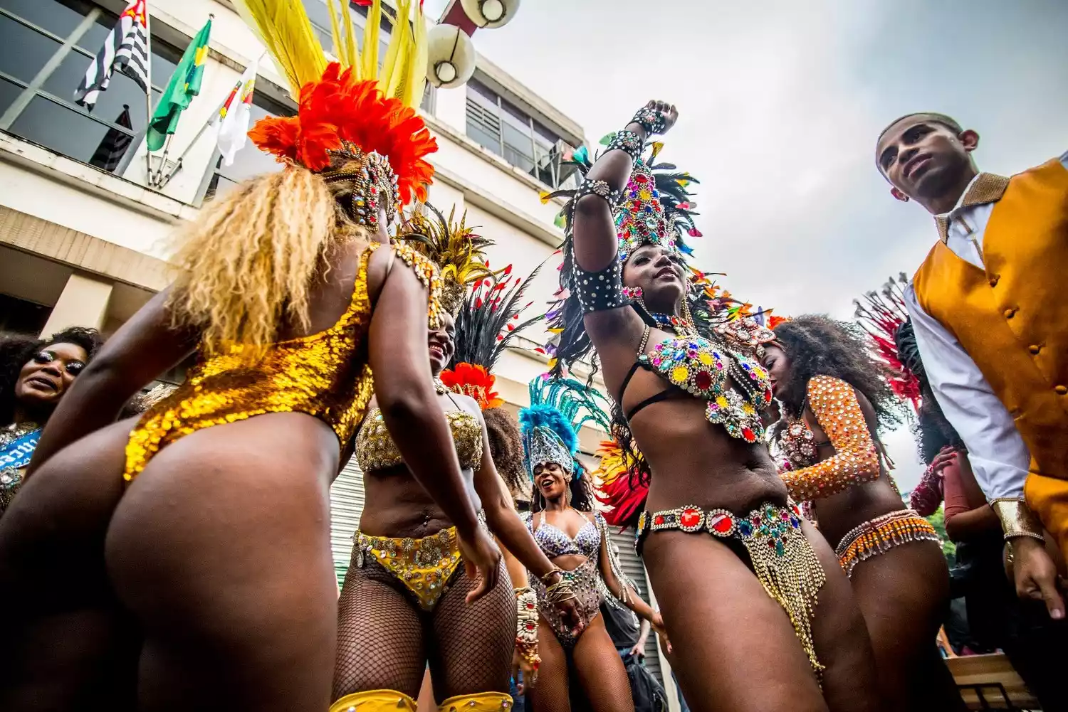
Two months before Carnival, you can also participate in the rehearsal of the Samba School (Escola de Samba). Samba School is not a samba training class. In fact, the dancers of the Samba School are the protagonists of the annual Carnival parade. Each school has thousands of people, most of whom come from nearby slums. They spend almost the whole year preparing for the parade.
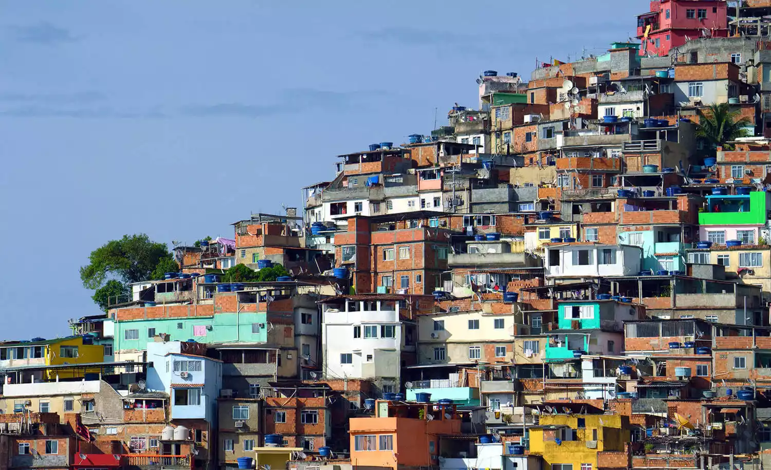
/Slum Tour/
There are a total of 700 slums of various sizes scattered throughout Rio, many of which are only across the street from the wealthy areas. Most of them are still under the control of armed drug traffickers, so it is recommended that you never go there alone. If an unfamiliar local invites you to enter the slums, please think twice, otherwise you may be robbed or even your life is threatened. In addition, the police generally do not provoke gangs to avoid crossfire.
If you want to visit a favela, it's recommended to use a reputable travel agency. Several tours are offered in Rocinha, Brazil's largest and safest favela. The residents are friendly and not exactly "poor." Most of them work as cleaners, doormen, receptionists, and drivers in more affluent areas.
Safety:
Rio is considered dangerous even by Brazilians, so it's best to travel with a local to minimize the risk. Never travel alone. Avoid traveling after sunset. It's best not to carry valuables with you, and don't take out your phone or camera. Look around to make sure it's relatively safe before taking out a quick photo.
Staying in a hotel is generally safe, but you should always be aware of safety.
transportation:
It is recommended to take a taxi or charter car service.
diet:
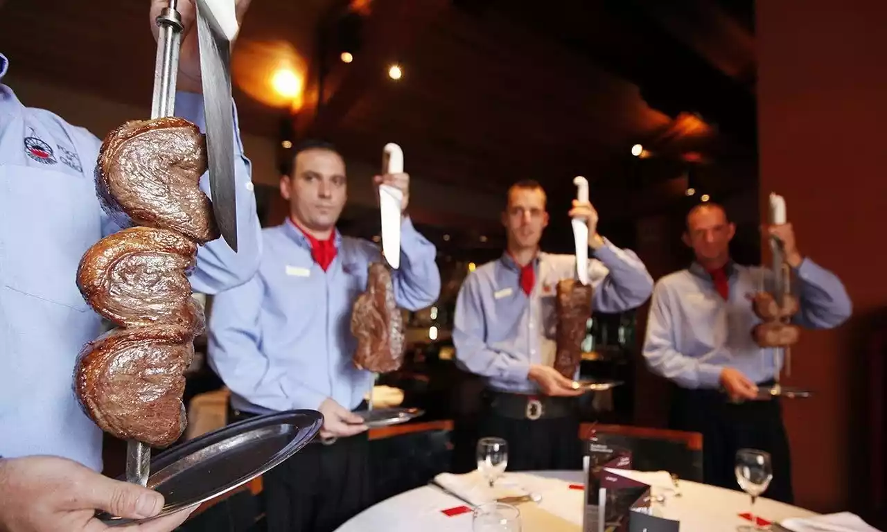
Churrasco
Brazilian barbecue is usually served as a buffet (Rodizio), where you can eat as much as you want, but drinks are not included. To preserve the original flavor of the meat, the only seasonings used in cooking barbecue are mashed garlic and salt.
There's a small card on the table. Flip it green and it'll say "Sim, Por Favor!" (Here, more!). The waiter will keep coming over to bring the grilled meat to the table, cutting off a slice with a sharp knife and placing it on your plate. When you're full, flip the card to the red side and it'll say "Não, Obrigado!" (No, thank you), and the waiter will stop harassing you.
The little secret to enjoying barbecue is to choose the right part of the meat. Brazilians' favorite parts are beef neck (Cupim), beef rump (Picanha), veal (Baby Beef) and chicken heart (Coração de Frango). In addition, Fraudinha (beef belly), Filet Mignon (beef tenderloin) and Alcatra (beef rump) are also worth trying.
Feijoada
Brazil's national dish, Feijoada, originated as a traditional meal for slaves, mixing ingredients their owners wouldn't eat. It spread, and today it's a Brazilian tradition to eat it every Wednesday and Saturday.
The main ingredients are beans, smoked dried meat, pig tails, pig ears, sausages, etc. Side dishes also include rice, chopped cabbage and sliced oranges.

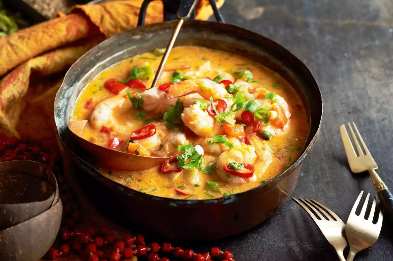
Moqueca
The most distinctive Brazilian seafood dish is the seafood chowder from the northeastern state of Bahia. This large pot of seafood, cooked in a rich broth with coconut milk and other ingredients, is perfect for sharing among three or four people. Dipping it in Bahian-style chili sauce will enhance the flavor.
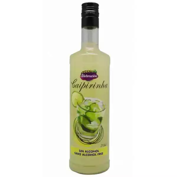
Caipininha
A visit to Brazil is a must-try: a Caipirinha, Brazil's national drink. This cocktail, made with sugarcane liquor (cachaça), lemon, ice, and sugar, is icy, sweet, and sour. A well-made Caipirinha is so smooth you barely even notice the alcohol. Caipirinha now comes in a variety of flavors, including kiwi, strawberry, orange, and watermelon.
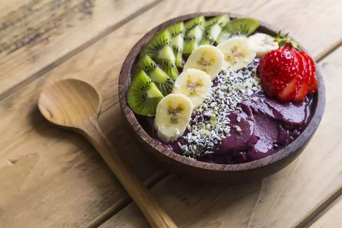
Açaí
A fruit that is native to the Amazon region. Because it is difficult to preserve, it is usually processed and frozen in the place of origin before being sold. It looks a bit like purple ice cream and has a subtle taste.
Many Brazilians believe that acai can bring health and strength to people, and modern scientific research has indeed found that acai is rich in minerals and trace elements.
In addition to the original flavor, the most common combination is acai and banana mixed flavors, sometimes with strawberry, which is easier for first-timers to accept.
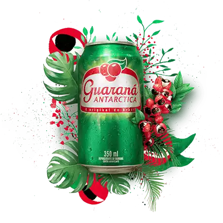
Guaraná
Guarana, a fruit native to the Amazon rainforest, is rich in caffeine and ranks among the highest in caffeine content in plants worldwide. Locals dry the guarana fruit, grind it into a light brown powder, and mix it with juice or water for a refreshing drink.
Guarana-flavored carbonated drinks are also very popular in Brazil, such as Guaraná Kuat produced by Coca-Cola and Guaraná produced by Brazilian company Antartica.
Appendix: Preparation before the trip
visa
Chile:
US visa exemption: If you hold a US visa, Schengen visa or Canadian visa (except transit visa) that is valid for more than 6 months, you can enter Chile visa-free, with a maximum single stay of no more than 90 days.
Visa fee waiver: If you don’t have a US or Canadian visa, don’t worry. Starting from July 1, 2019, the Chilean government will waive visa application fees for Chinese citizens traveling to Chile for tourism or business.
2. Argentina
US e-visa: If you hold a US/Schengen visa valid for more than 6 months, you can directly apply for an e-visa. (Fujian passports need to apply for a stamped visa)
3. Brazil
You need to apply for a Brazilian visa, which is valid for 5 years and can be used for multiple entries.
Many people choose to apply for a Brazilian visa in Argentina. There are two places to do this:
- Buenos Aires, Argentina: approximately 3 working days;
- Iguazú, a city on the border between Argentina and Brazil. If you are lucky, you can get a visa in one working day.
If you are traveling to all three countries at the same time, it is recommended that you apply for a US visa + a Brazilian visa + an Argentinian electronic visa. It is convenient to apply for and is valid for ten years. With the US visa in hand, you can travel at any time.
currency
Chile
1 Chilean Peso = 0.010 RMB
1 RMB = 98.78 Chilean Pesos
2. Argentina
1 Argentine Peso = 0.16 RMB
1 RMB = 6.12 Argentine Pesos
3. Brazil
1 Brazilian Real = 1.80 RMB
1 RMB = 0.56 Brazilian Real
It is recommended to exchange currencies of various countries in advance and bring a VISA credit card. Although VISA bank cards can be used locally, many places still use cash transactions, and ATM fees are high, which is very troublesome.
vaccine
Yellow fever vaccine
The yellow fever vaccine must be administered 10 days before traveling abroad. Vaccination provides lifelong immunity. Contraception is recommended for three months after vaccination, as mild side effects may occur. Yellow fever is primarily transmitted through mosquito bites and is common in Africa and Latin America. Symptoms are similar to those of a cold, including fever, chills, muscle aches, nausea, vomiting, and fatigue. In severe cases, liver or other organ damage may occur, leading to death.
What is yellow fever?
Yellow fever is an infectious disease caused by the yellow fever virus and transmitted to humans through the bites of infected mosquitoes.
List of countries with yellow fever areas
33 African countries:
Benin, Chad, Congo, Guinea, Equatorial Guinea, Ethiopia, Ghana, Ivory Coast, Nigeria, Sierra Leone, Sudan, Uganda, Zaire, Cape Verde, Burundi, Eritrea, Gambia, Guinea-Bissau, Rwanda, Sao Tome and Principe, Somalia, Tanzania, Cameroon, Kenya, Liberia, Mali, Angola, Burkina Faso, Gabon, Mauritania, Senegal, Togo, Central African Republic.
11 South American countries:
Brazil, Bolivia, British Guiana, Colombia, Ecuador, French Guiana, Panama, Peru, Suriname, Paraguay and Venezuela, Argentina
Personal belongings
Hydrating mask
It is said to be the driest desert in the world. You can imagine the consequences if you don’t bring moisturizing products. Moreover, the moisturizing products in South America are different from those in China. They may not be suitable for the skin types of people in China, so it is recommended that you must bring moisturizing products.
socket
It is recommended to bring several universal sockets, because even different regions in the same country may have different sockets.
water cup
There is no hot water in South America, so friends who want to drink hot water can bring a heating cup.