Day 1 Kilimanjaro Airport → Arusha/Moshi Town ★Meeting day
All day
Guests arrive at Kilimanjaro International Airport on an international flight. After completing immigration formalities, collect your luggage and exit the airport gate.
Note 1: We will arrange a free group airport pick-up. The pick-up time is based on Ethiopian Airlines flight ET815. The arrival time is 10:40 (subject to actual arrival time). Please be sure to arrive on time. If you arrive late, you will need to go to the meeting hotel on your own.
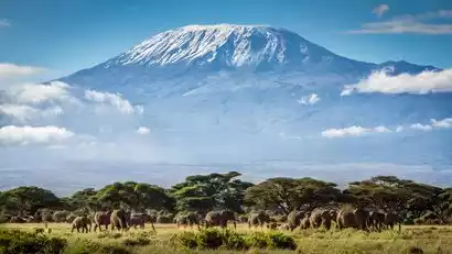
Our driver will greet you at the entrance with a sign. We'll then proceed to your hotel in Moshi or Arusha, a popular destination for mountaineering enthusiasts. This is the gateway to Mount Kilimanjaro, Africa's highest mountain.
Note 2: Check-in at the hotel is after 2 p.m. If you arrive early, you can check in at the hotel first.
After checking in, we settled into our rooms and rested. Later, our English-speaking mountain guide (whose English is best translated) arrived at the hotel to brief all climbers on the Kilimanjaro itinerary. He then confirmed that everyone's equipment met the requirements and arranged a departure time for the next day. Dinner was served at the hotel, and we retired early.
Note 3: Starting from November 1, 2025, an airport tax of US$90 per person will be charged for entry into Tanzania. Please prepare cash.
How to book a flight
Recommended custom flights: Ethiopian Airlines
Outbound reference:
ET685 00:20-06:00 Shanghai PVG-Addis Ababa ADD
ET815 10:35-12:55 Addis Ababa ADD-Kilimanjaro JRO
The pick-up time is based on the arrival of flight ET815 at Kilimanjaro Airport. The above flight time is for reference only. EgyptAir flight times are frequently adjusted and may vary in different time periods (e.g., arrival times may differ during summer vacation and National Day).
You can choose to compare prices on various air ticket platforms. For reference, you can refer to Ctrip, Fliggy, etc. If you need to book on your behalf, please consult the product manager or customer service.
[Special Benefit] Register for the 2025 National Day group tour (9.30, 10.1) from now on and you will have a chance to win a set of Pelliot 7+2 custom-made jackets and Pelliot alpine down jackets with a total value of 4,000 yuan.
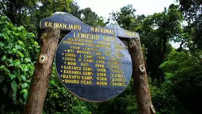
Day 2 Arusha/Moshi → Landauros Gate (2100m) → Morum (3500m) → Shira Camp 1 (3505m)
All day
After breakfast at the hotel, we will depart from the hotel and drive for more than 3 hours to the Londonorossi Gate located west of Mount Kilimanjaro.
You will go through the climbing formalities at the entrance and meet up with your climbing team. After completing the formalities, you will take another 12 km bus ride to Morum, the starting point of the climb.
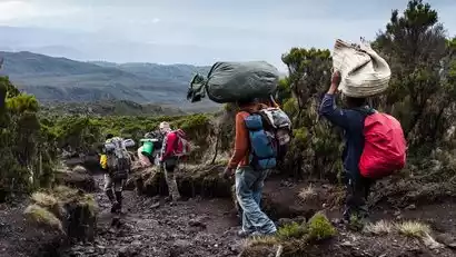
After lunch, we began our first day of climbing. The climb from Morum to Shila Camp 1 involved a slight elevation gain, but it wasn't too challenging, making it a relatively gentle start. We passed through a vast grassland covered in tall grass, heather, and volcanic rocks.
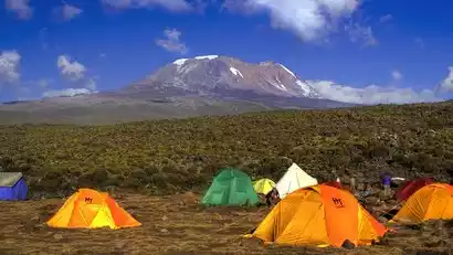
Continuing through several rolling hills with dense vegetation and passing several streams, we reached the Shira Ridge and then gently descended along the slope to Shira Camp 1. Here, we had our first view of Kibo Peak from the plateau. Upon arrival, our staff had already prepared everything necessary, including setting up the tents and cooking dinner.
Day 3 Shila Camp 1 (3505m) → Shila Camp 2 (3850m)
All day
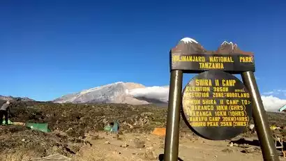
From Shira Camp 1 (3505m), we embark on a light hike to the second high-altitude camp, Shira Camp 2 (3850m). The hike passes through hot and swampy terrain, with stunning views of the Shira Ridge.
This hike is not difficult and offers stunning views of Africa and the unique flora of Mount Kilimanjaro and its surroundings. Weather permitting, Shira Camp 2 offers a viewpoint from which to view Mount Meru, Africa's fifth-highest mountain. The ever-changing landscape will again surprise you with its varied terrain, and you'll walk on land that once flowed lava. Tonight's destination is Shira Camp 2 (3,900m), 400m higher than the previous night.
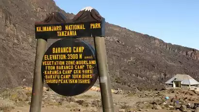
Day 4 Shila Camp 2 (3850m) → Barankao Camp (3900m)
All day
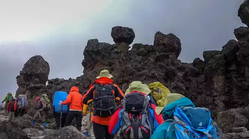
After breakfast, you'll depart Shira 2 Camp (3,850 meters) and head toward Lava Towers at 4,650 meters. The hike to Lava Towers involves a long trek through moorland and swamps with impressive vegetation, with many ups and downs along the way, ultimately concluding at Campsites above 4,600 meters. This hike is challenging and can be uncomfortable, but you'll need to spend at least 1-2 hours here to successfully acclimate to the altitude, so this is where you'll have lunch.
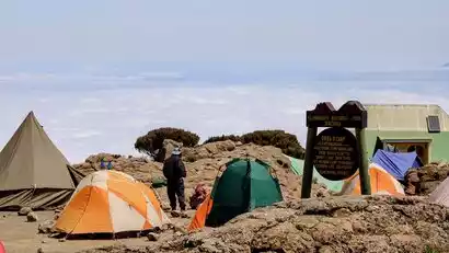
You'll rest here before continuing your descent. This is the so-called acclimatization day, where you'll climb high but sleep low, giving you a good understanding of how your body reacts to the altitude. The scenery will change again as you cross the Barranco Valley, home to large groundsel and smaller lobelia plants. After a long 6-7 hours, you'll reach the beautiful campsite and spend the night at Barranco Camp. There, the crew will be waiting for you, enjoying a well-deserved dinner before settling in for the night.
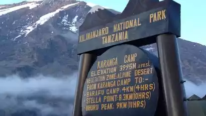
Day 5 Barankao Camp (3900m) → Kalanga Camp (4035m)
All day
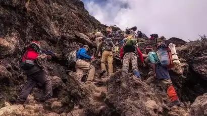
After breakfast, we'll begin our ascent of the Barankao Walls (we recommend leaving camp early to avoid the crowds). Enjoy breathtaking views of the Kibo South glacier, rising and falling. The hike up the canyon walls is easy and takes only about an hour. After the climb, you can rest and take photos in front of Kibo Volcano. Safety is paramount, so please follow your guide's instructions, and they will lead you safely to the summit. You may need to use your hands from time to time to gain a better grip, but rest assured, there are no alpine climbing routes. Upon reaching the summit, we'll begin a more challenging hike to Kalanga Camp, with many ups and downs. After a few hours, you'll complete an acclimatization hike toward Barafu Camp, gaining 200 meters in elevation before returning to camp.
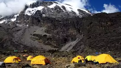
Day 6 Kalanga Camp (4035m) → Barafu Camp (4640m)
All day
After breakfast, you will begin your journey to Barafu Camp (4640m), the starting point for your overnight climb to Uhuru Peak (5895m).
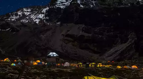
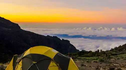
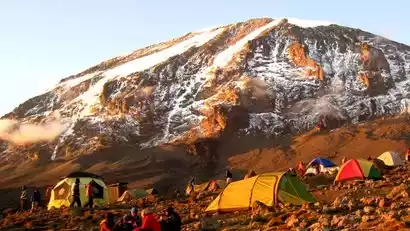
After about 3-4 hours of hiking, we'll reach Barafu Camp. The breathtaking sea of clouds along the way offers a truly breathtaking spectacle. From here, you can also see Kilimanjaro's two highest peaks—Kibo and Mawentsi. Barafu means "ice" in Swahili, suggesting you'll spend the night in a cold and desolate campsite. Tents can only be pitched on a narrow, hard, and treacherous ridge, so be sure to familiarize yourself with the terrain before dark to avoid any accidents. Our team will set up camp in advance, including your tent and sleeping bag, so you can relax and unwind.
Prepare your summit preparations in advance, including trekking poles, warm clothing, and replacement headlamp and camera batteries. To prevent water from freezing, keep it in a thermos. Try to go to bed early to get more rest and energy.
Day 7 Barafu Camp (4673m) → Summit Uhuru Peak (5895m) → Maweka Camp (3090m) / Millenium Camp
All day
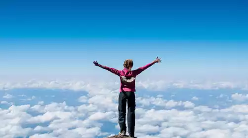
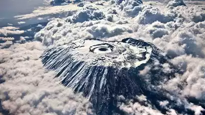
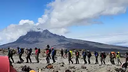
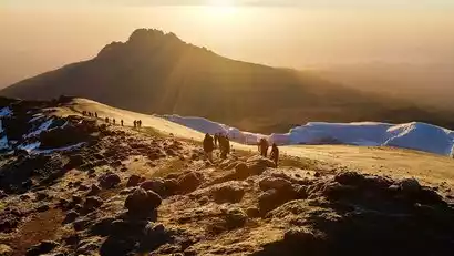
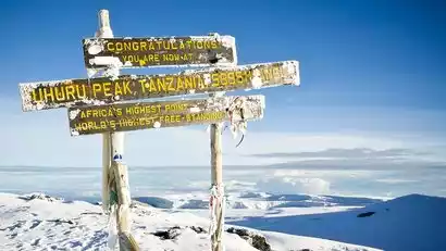
Departing early in the morning for the summit, we'll first spend six hours reaching Stella Point on the crater's rim. From Stella Point, the ascent to Uhuru Peak, the summit of Africa, takes approximately two hours. Technically, the climb is relatively easy; however, the altitude is the most challenging part. Now you can savor the sense of accomplishment of having conquered the Roof of Africa—a memory you'll never forget.
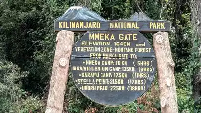
After taking all the photos you need, you'll return to Barafu Camp for a 1-2 hour rest. Once everyone is well rested, you'll continue to Mweka Gate (3,080 m), a 3-hour hike. The rest of the evening is yours to relax, enjoy a delicious dinner, and get a good night's sleep.
Note: During the descent, please remain vigilant and cautious. The campsite is located in the forest, and light drizzle and mist are possible even at this altitude. Before your rest, you can quickly wash up and enjoy a chef-prepared dinner.
Day 8: Maweka Camp/Millenium Camp (3090m) → Maweka Gate (1630m) → Arusha/Moshi
All day
After breakfast, depart for a 3-5 hour hike through the rainforest to the Maweka Gate. Before the final leg of your journey, you'll enjoy a traditional farewell ceremony from your mountain guide. Your driver will be waiting there to take you back to your meeting point. You'll have the rest of the day to freshen up, relax, and enjoy all the excitement of the past few days.
PS: Maweka Campground is about 8km, 3h, and Millenium is about 11km, 5h
Day 9 Arusha/Moshi → Kilimanjaro Airport ★ Dismissal Day
All day
After breakfast at the hotel, you can choose to transfer to Kilimanjaro Airport at your own expense according to your flight schedule, or continue your itinerary.
丨Can order and deliver to the airport
The cost is as follows: US$80/(2 people per car)/one trip [four-seater car]