
Day 1 Various locations - Urumqi (★Activity gathering day)
All day
Today is the all-day gathering day in Urumqi. Tourists from all over the world are heading to Urumqi, the capital of Xinjiang Autonomous Region, known worldwide as "the land of song and dance, the land of melons and fruits, and the land of gold and jade." Everyone will proceed to the meeting hotel on their own, and check in at the front desk with "China - Travel Note + Name." If you have more time, you can also arrange your own sightseeing activities in Urumqi city. Please exercise due caution during your free time.
If you're interested in learning about Xinjiang's culture, geography, and history, visit the Xinjiang Museum. For a taste of the region's culture and a bit of shopping, head to the Erdaoqiao International Grand Bazaar. While you're in Urumqi, you can't miss the local cuisine. Don't miss Xinjiang's big plate chicken, spicy chicken, or the crispy, tender grilled lamb chops. You can also stock up on Xinjiang fruits (like apples and pears) and local food (baked naan is highly recommended, but don't overdo it).
Kind tips:
Urumqi Tianshan International Airport is close to the meeting hotel in the city. A taxi to the meeting hotel is about 30-45 yuan.

Day 2 Urumqi → S21 Desert Highway → Sea Devil City → Altay City
·morning
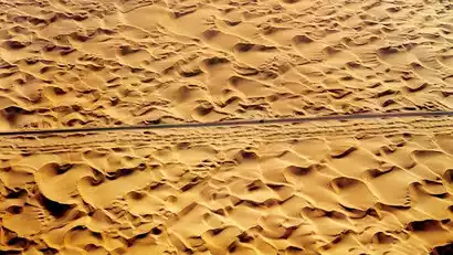
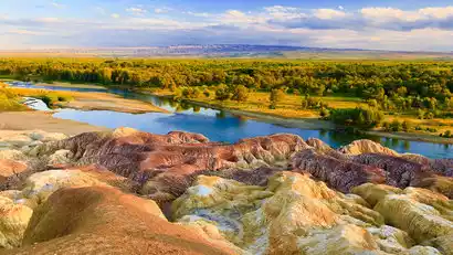
We will leave after breakfast and drive along the S21 Desert Highway through the heart of the Junggar Basin, known as the second largest basin in China. It is a bridge connecting the Tianshan Mountains and the Altai Mountains. Along the way, we can see grasslands, deserts, Gobi, Yardang and other landforms. If you are lucky, you can also see wild donkeys, wild horses and wild camels on the bus.
·afternoon
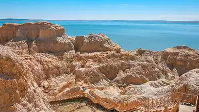
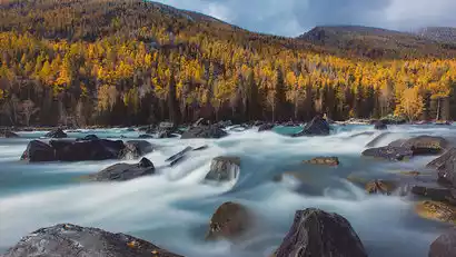
Enjoy lunch en route before arriving at the Devil's City on the Sea, a unique "ocean" for Xinjiang residents. The spectacular Yadan landforms blend with the rippling waters of the lake, creating a natural wonder: "half mountain, half sea, where the mountains end and the sea begins."
After the photoshoot, we will go to the hotel in Altay City to rest. In the evening, we can meet up with each other to enjoy the delicious Altay big-tailed sheep.
Day 3 Altay City → Ahe Highway → Hemu
·morning
After breakfast, we set off to apply for border passes and then cross the Ahe Highway.
Since its opening to traffic in September 2024, this lesser-known border highway has become a mecca for countless photography enthusiasts. The 208-kilometer Ahe Highway, starting from the city of Altay, passes through mountains, forests, grasslands, rivers, wetlands, and canyons, offering ever-changing scenery and the opportunity to encounter adorable foxes.
Ahe Highway Description:
The Ahe Highway is a border highway, and its road conditions are affected by weather and policies. We cannot guarantee that it will be accessible every day.
If the road is impassable, alternative itinerary: D3 will take a detour via Burqin to Hemu, and take the provincial road from the scenic area gate to Hemu, which will increase the time for sightseeing and photography in Hemu. Please understand.
·afternoon
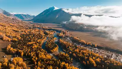
Arrive at Hemu, "God's Private Reserve." After arranging your accommodations in Hemu Village, you'll have free time to photograph the Tuva people and Hemu's natural scenery. If you're interested, you can also take a horseback ride to photograph the beautiful Big and Small Meili Peaks (at your own expense, please exercise caution when riding).
At dusk, you can go to the Hemu Observation Deck to take a bird's-eye view of the Hemu Village, the Tuva villages with smoke rising from cooking fires in the sunset, and the cattle and sheep returning home from grazing.
Interested tourists can continue their starry sky creation while staying in the scenic area at night.
Day 4 Hemu → Kanas
All day
Today, we'll rise early to head to the Hemu Observation Deck to secure a prime vantage point for panoramic photos of the misty Hemu sunrise. The morning light will cast a shadow over the golden birch and western Siberian pine forests, while mist drifts through the valley and smoke rises from cooking fires. The scene is breathtaking and breathtaking. We'll then return to the hotel for breakfast.
Take the scenic bus to leave Hemu at the right time and head to Kanas, the "Back Garden of God", along the scenic road.
The autumn here seems to have an overturned palette, with the leaves gradually turning red, bright yellow, brown-yellow, green, etc., and against the backdrop of blue sky, white clouds and towering snow-capped mountains, it is like a fairyland on earth.
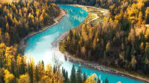
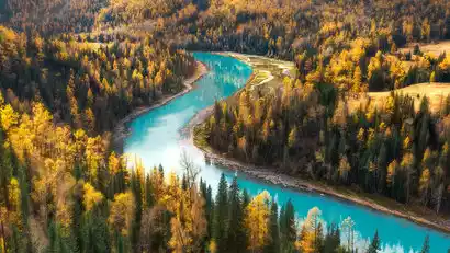
Arrive at Kanas Transfer Center, change scenery and transfer to the bus to Kanas Lake. Walk along the lakeside plank road, take pictures of the golden autumn colors on both sides of the lake, and take slow-motion photos of the flowing water of Kanas River.
Conditions permitting, we will ascend to the Fish-Watching Terrace at an altitude of 2,030 meters. With a vertical drop of over 600 meters above the lake, we can overlook Kanas Lake and its Three Bays. If the weather is good, we may even be able to photograph the snow-capped Friendship Peak on the Sino-Russian border.
Day 5 Kanas → Baihaba
·morning
Get up early and take photos of the famous Kanas Three Bays (Shenxian Bay, Moon Bay, and Wolong Bay), the morning mist at Shenxian Bay, the beautiful and hazy Moon Bay, and Wolong Bay. You can also take a short hike along the Kanas River (Moon Bay to Wolong Bay, 3KM, mainly downhill) depending on your physical condition, and take photos as you walk.
·afternoon
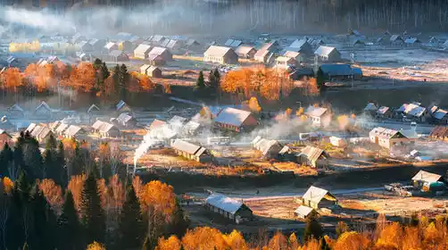
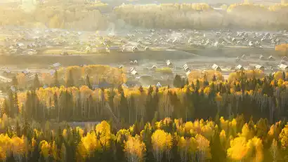
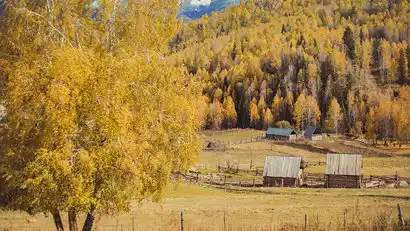
At the right time, head to Baihaba, known as the "First Village in Northwest China." Baihaba is a tranquil and beautiful mountain village, far from the hustle and bustle of the city, and has long preserved its simple and honest folk customs. After arranging your room, you can freely photograph the village, watching the sunset, the cattle and sheep returning to graze, and the smoke rising from the chimneys. Please be careful during your free time!
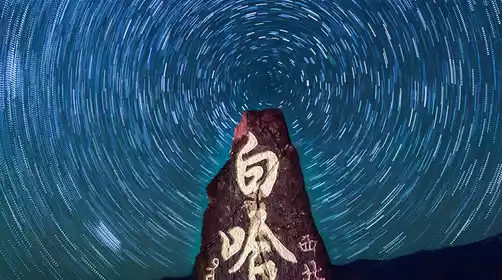
Stay overnight in Baihaba, where the night sky is dotted with stars. It is a great place to photograph the stars and star trails. Tourists who love star photography should not miss it.
Day 6 Baihaba → China-Kazakhstan Border Highway → Hujirt Transit Road → Wucai Beach → Burqin
·morning
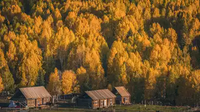
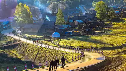
Get up early to take pictures of Baihaba in the morning light. Smoke rises from the chimneys and the surrounding snow-capped mountains are majestic. Baihaba, nestled among the mountains, is even more tranquil and beautiful. Experience the real life of the Tuva and Kazakh people.
·morning
Take the scenic shuttle bus to leave Baihaba at the right time, walk and take photos along the Baihaba border line, and record the unique autumn scenery of the China-Kazakhstan border highway (stop according to the scenic area shuttle policy).
Afterward, we'll journey south, enjoying the vibrant autumn scenery of the Altai Mountains in northern Xinjiang. En route, we'll pass the Hujirta Migration Route, a major herdsman route in the Altai region. Every autumn, herders migrate their flocks and herds from higher-altitude pastures to lower-elevation pastures. With luck, you might witness large herds of herders passing through. China-TravelNote has allowed ample time to photograph the herders' migration. (The migration schedule varies from year to year, lasting approximately two to three weeks. Weather and other factors may affect this, so photographing this migration may not be possible for every group. Please understand.)
·afternoon
We will depart at an appropriate time based on the availability of shuttle buses and head to Wucai Beach to photograph the waterside Danxia landforms, the colorful riverbank at sunset, and the Sunset Bridge. We will then return to the hotel to rest.
In the evening, you can continue to visit the riverside night market and freely explore and taste local specialties.
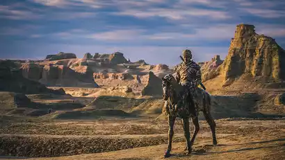
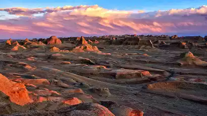
Day 7 Burqin → Grassland Stone City → Wuerhe Ghost City → Wuerhe Town
·morning
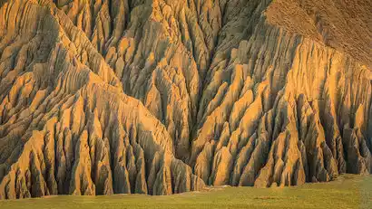
After breakfast, we'll depart for the Grassland Stone City. Here, you'll be struck by the myriad of giant granite rocks dotting the prairie. These are masterpieces sculpted by ancient glacial movement and eons of wind, frost, rain, and snow. These massive rocks, each with its own unique shape, resemble towering castles, recumbent beasts, and towering pillars, all vivid and visually striking. The Tongtian Cave ruins are also a significant archaeological site, where deposits of cultural layers dating back 45,000 years have been discovered, representing the transition from the Middle to the Late Paleolithic period.
·afternoon
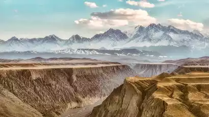
Drive south to the Urho Devil City, voted the most beautiful Yadan in China by National Geographic. In the afternoon, enter the Devil City scenic area (if it's still early, return to the hotel to rest). Millions of years of wind erosion have shaped the unique Yadan landforms. Enjoy photos of the Devil City at sunset, capturing the breathtaking beauty of this wind-filled city. After your photo session, return to the hotel to rest.
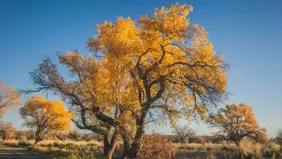
Day 8 Wuerhe Town → Wuerhe Secret Populus euphratica Forest → Anjihai Grand Canyon → Kuitun
·morning
Departing early in the morning, we set off to capture the dawn glow of the secret Wuerhe Populus euphratica forest, exploring the renowned poplars known for their immortality, immortality, and immortality. This is a large, wild poplar forest privately discovered by the China-TravelNote team. Following the sandy road deeper, we parted ways with the dense forest, revealing a magnificent expanse of trees. Each tree, untamed and unruly, stood upright or tilted against the sandy soil, their mystery shone with vitality and hope.
·afternoon
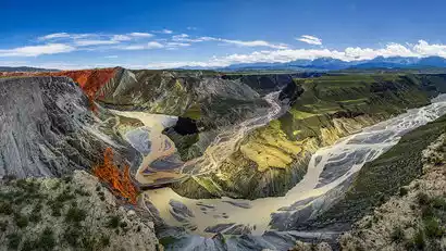
After lunch, we'll go photograph the Anjihai Grand Canyon (also known as the Red Mountain Grand Canyon). It's reopened after four years! Glacial meltwater has eroded the Tianshan Mountains, creating a rift valley over 100 meters deep. The exposed rocks, reddish-brown karst landforms, terraced grasslands, and braided river channels create a breathtaking natural landscape. After enjoying our photo ops, we'll return to our hotel for the night.
Day 9 Kuitun → Dushanzi Grand Canyon → Urumqi (★Event Ending Day)
·morning
Depart early in the morning to photograph the sunrise at Dushanzi Grand Canyon. Dushanzi is located on the northern side of the Tianshan Mountains. Years of precipitation from snow and rain have carved the steep cliffs into a crisscrossing pattern of gullies, revealing a texture reminiscent of leaf veins. The spectacular scenery is truly remarkable, inspiring awe at nature's ingenuity.
·afternoon
After a satisfying photoshoot, we departed. We were expected to arrive in Urumqi at 1:00 PM. We were taken to Urumqi Tianshan International Airport (Diwopu Airport), then to Urumqi Railway Station, and then to our hotel in the city. Having forged strong bonds over the past few days, we were reluctant to leave, with a tearful kiss.
Return transportation tips:
Please book your return flight and train tickets after 15:00. Tourists should leave Urumqi according to their respective flight or train times.