Day 1 Various locations - Urumqi (★All-day gathering day)
All day
Today is the gathering day for the event. All tourists will proceed to the meeting hotel in Urumqi, the capital of Xinjiang Autonomous Region. Simply provide "China-Travel Note + Name" to check in.
Located in the heart of Asia, Urumqi is a world-renowned city of song and dance, a land of melons and fruits, and a land of gold and jade. If you have more time, you can plan your own activities in Urumqi city. For those interested in learning about Xinjiang's culture and history, the Xinjiang Museum is highly recommended (free, entry only after 6:00 PM; closed on Mondays). For an exotic experience, the Erdaoqiao International Grand Bazaar showcases unique Western culture and a dazzling array of goods, promising great finds.
When in Urumqi, don't miss the delicious Xinjiang cuisine: the nationally renowned Dapanji (Big Plate Chicken), crispy grilled lamb chops, grilled lamb skewers, Yili horse intestines, and various specialty noodles. Sunset usually occurs at 10:00 PM in the summer, and Urumqi remains bustling at night. Explore the Grand Bazaar Night Market for a bite to eat.
Border Pass Description
The team will go together on D6 to apply for a border pass, one per person (bring ID card, apply in person); children under 16 years old: must be accompanied by their parents (bring household registration book + ID card).
Kind tips:
Urumqi Airport is close to the city center. A taxi from the airport to the meeting hotel costs about 30-45 yuan (taxis are available 24 hours a day, safe and reliable).

Day 2 Urumqi → Anjihai Grand Canyon → Duku Highway (Northern Section) → Qiaoerma → Tangbula Grassland → Nalati Town
·morning
After breakfast, the off-road vehicle driver will arrive at the hotel on time to pick up the tourists. After a brief ice-breaking, the pleasant journey will begin.
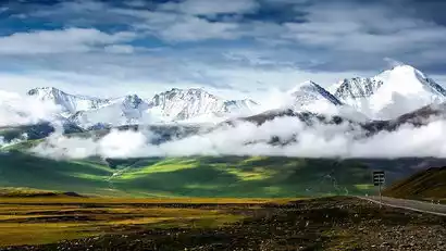
The first stop is to visit the Anjihai Grand Canyon (also known as the Hongshan Grand Canyon). The Tianshan Mountains have been impacted and weathered by glacial meltwater, forming a large rift valley more than 100 meters deep. The exposed rocks, reddish-brown karst landforms, stepped grasslands, and braided river channels form a natural picture scroll.
·afternoon
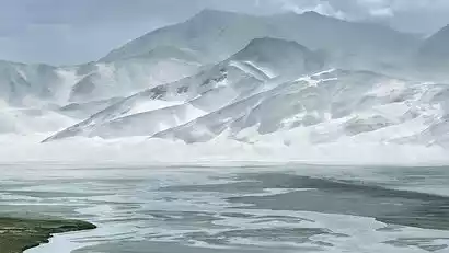
In the afternoon, we officially embarked on a journey across the Duku Highway (opened to traffic on May 31, 2006). The 561-kilometer Duku Highway, which runs through the Tianshan Mountains from Dushanzi to Kuqa, is the primary highway connecting southern and northern Xinjiang. Traversing towering peaks and traversing deep valleys and gorges, it shortens the distance between southern and northern Xinjiang by half, a milestone in China's highway construction history. Tens of thousands of soldiers toiled for 10 years to build this highway, with 168 of them sacrificing their lives.
Afterwards, we officially entered the Duku Highway, passing the Tianshan Guardian Stele and Hashilegenda Pass (3,460 meters), where we might even see some unmelted snow if we were lucky.
Arrive at Qorma, then drive west along the Kashgar River, enjoying a beautiful "hundred-mile gallery" [Tangbula Grassland] along the way, then return to Qorma and continue along the Duku Highway, arriving at the hotel in the evening to rest.
Day 3: Nalati Town → Nalati Grassland → Duku Highway (middle section) → Bayinbuluke
·morning
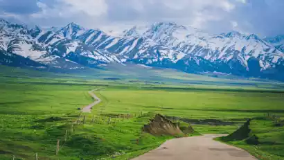
After breakfast, we'll explore the Nalati Sky Grasslands. Known since ancient times as a pasture, the grasslands were once home to Genghis Khan during his western expeditions. The grasslands are dotted with springs, crisscrossing streams, and lush forests, earning them the nickname "Sky Grasslands."
·afternoon
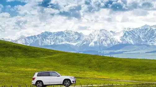
After passing the famous Gongnaisi River Valley, the Bayinbuluke Grassland appears before your eyes, dotted with yurts, herds of black-headed sheep, pastoral songs from cooking fires, and snow-capped mountains in the distance, the scenery is endless.
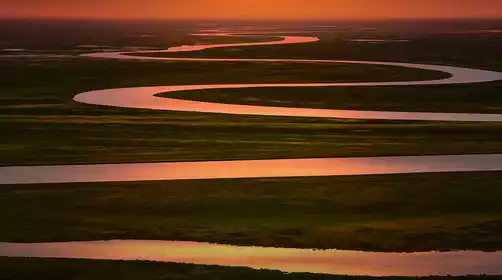
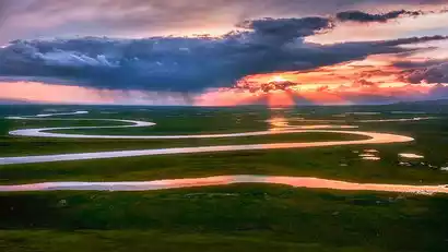
In the evening, take the scenic shuttle bus to the Bayinbuluke Scenic Area, where you can admire and photograph the plateau wetlands, the beautiful Swan Lake, the Bayinbuluke wetland grassland, and the sunset glow of the winding Kaidu River. On a clear evening, you can see a series of setting suns reflected on the river. After sunset, return to the hotel to rest.
Day 4 Bayinbuluke → Duku Highway (Southern Section) → Tianshan Stone Forest (Secret Secret) → Kuche Tianshan Grand Canyon → Kuche
·morning
After breakfast, we'll depart and continue our journey across the Duku Highway (Southern Section). The Bayinbuluke Grassland is breathtakingly beautiful in the early morning. Sunlight bathes the lush green grasslands, smoke curls from yurts, herds of cattle and sheep graze leisurely, horses gallop, and in the distance, the rolling snow-capped peaks of the Tianshan Mountains stretch out.
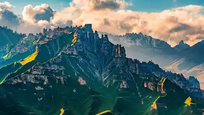
China-TravelNote will take you on an exploration of the Tianshan Stone Forest, a wonder known only to local photographers. Climbing to the summit of Kokwusuda Pass, you'll gaze out upon a primeval forest nestled among snow-capped peaks, scattered along the slopes flanking a deep valley. A closer look reveals not pines and cypresses, but a graceful, graceful "stone forest." Millions of years of natural processes have sculpted this sandstone and rocky landscape into a myriad of bizarre and captivating shapes. Some resemble ancient castles, others resemble lifelike figures of people and animals, and still others resemble swords, spears, and halberds, piercing the blue sky.
Tianshan Stone Forest Description: (Updated on August 29)
Tianshan Stone Forest is currently closed due to local regulations. China-TravelNote will monitor road conditions and await restoration.
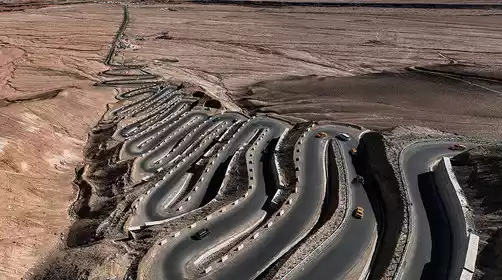
Alternative itinerary during the closure: Upgrade to an off-road vehicle and drive through the Bayinbuluke Scenic Area on Days 3 and 4, visiting Tongtian River and the Bayinbuluke Devil's Raceway, the filming location for the movie "Speeding Life." The Devil's Raceway is in poor condition. If weather conditions prevent access or the track is closed, turn around and return to the Duku Highway along the Kaidu River Wetland.
·afternoon
Continue to cross the Duku Highway, pass the Tielimati Pass in the Tianshan Mountains, and officially enter the southern Xinjiang landscape. The scenery gradually changes, the grasslands and snow-capped mountains gradually disappear, and the dry, hot and dark southern Xinjiang Gobi landscape gradually appears.
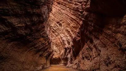
Passing Dalongchi and Xiaolongchi, we arrived at the Tianshan Grand Canyon. The Grand Canyon was formed by reddish-brown rocks through millions of years of wind and rain erosion. The winding paths lead to secluded caves, and the light shining through from the top of the canyon creates rich changes in light and shadow. It is known as the "Xinjiang Antelope Valley".
We'll stop by the Duku Highway Terminus for a souvenir photo. In the evening, we'll arrive in Kuche, a small city in southern Xinjiang. Anciently known as Qiuci, Kuche was a key stop on the ancient Silk Road, rich in exotic charm. In the evening, we'll have free time to explore southern Xinjiang delicacies (barbecue, mixed noodles, pepper chicken, meatball soup, and more, including the wheel-sized Kuche naan).
Day 5 Kuqa → Red Stone Forest → Fiery Spring → Kizil Thousand Buddha Caves → Aksu
·morning
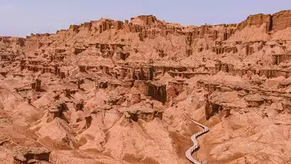
After breakfast, we'll depart for China-TravelNote's newly discovered, lesser-known Red Stone Forest. This forest is composed of reddish-brown Yardang wind-eroded landforms. Millions of years of wind and rain erosion in an arid environment have shaped the rock and soil into a diverse array of valleys, peaks, terraces, and pillars. Within the winding gullies, large and small, layers of brown-red, yellow-green, and gray-green earthen blankets overlap, resembling a deserted historic city.
·afternoon
Not far from the Red Stone Forest, we will visit the magical [Flame Spring] (also known as Hellfire). Under the land of southern Xinjiang, there are rich minerals, and natural gas leaks from the surface through cracks in the rock strata, forming a never-extinguished hellfire.
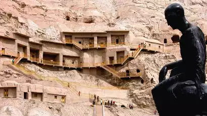
Afterwards, we'll visit the Kizil Thousand Buddha Caves, which predate the Mogao Caves in Dunhuang by over a century. They are China's earliest grottoes and a key part of the Silk Road World Heritage Site. For millennia, Buddhism flourished here, with numerous monks, and it was from here that Buddhism spread to the Central Plains.
After having fun, go to the Apple City [Aksu City] hotel to rest.
Flame Spring Description (Updated on August 28)
The Flame Spring scenic area is temporarily closed due to temporary road construction. During the closure, the visiting time of the Red Stone Forest scenic area will be increased. Thank you for your understanding.
Day 6 Aksu → Kashgar (half day free at leisure)
·morning
After breakfast, we'll depart westward for Kashgar, passing the spectacular red-bed landscape of the Tianshan Mountains along the way. "If you haven't been to Kashgar, you haven't really been to Xinjiang." Kashgar was a major commercial port on the ancient Silk Road, a crucial intersection of Central Asian economies, transportation, culture, and civilization.
·afternoon
Arrive in Kashgar City at noon and apply for a border pass to Tashkurgan County. The afternoon is free for you to relax. Tourists can also visit Kashgar Old Town (free of charge).
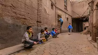
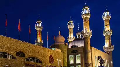
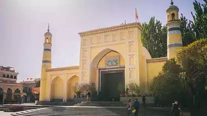
In Kashgar's Old City, you can visit the magnificent Id Kah Mosque (a paid attraction). All roads in Kashgar's Old City lead to this mosque, which serves as more than just a place of worship for Muslims; it serves as a spiritual haven. Kashgar's Old City boasts a maze-like network of houses, all constructed in a uniform Islamic style of earth, wood, and brick. The century-old teahouse on the corner served as a filming location for the movie "The Kite Runner." Children playing in the alleys are eager to pose for photos, their bright eyes revealing their pure hearts. In the evening, discover local delicacies at the Khan Bazaar Night Market (opposite the mosque).

Day 7 Kashgar → Karakoram Highway → Baisha Lake North Shore → Muji Township Volcanoes → Taheman Wetland → Tashkurgan County
·morning
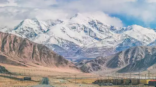
Today, we'll travel along the Karakoram Highway, a friendship highway between China and Pakistan, toward the Pamir Plateau. "Pamir" means "Roof of the World" in Tajik, and the ancient Silk Road passed through this region. Along the way, we'll admire the magnificent Aoyitake Red Mountain, also known as the "Flaming Mountain of Southern Xinjiang."
Along the way, visit the North Shore of Baisha Lake. Compared to the more touristy South Shore, here you can enjoy the magical landscape of blue lakes and sand dunes.
·afternoon
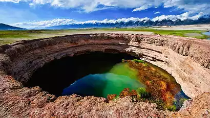
In the afternoon, we arrived at the mysterious border village of Muji Township, home to the unique Kare Temir Volcanic Cluster, with 13 craters formed by eruptions 1,500 years ago. The iconic craters, rare plateau wetlands, clear glacial lakes, and sweet glacial water will leave you marveling at the magical charm of nature. In the distance, the snow-capped mountains, lined up in a row, are known as the "Eighteen Arhats Snow Mountain Honor Guard," guarding this secret plateau landscape.
Afterwards, we passed by [Taheman Wetland] and admired the wetland grassland nurtured by the meltwater of the Muztagh Ata glacier from the observation deck.
After enjoying the fun, we'll head to Tashkurgan County, a small border town (around 3,000 meters above sea level, with little altitude sickness). Its population is primarily Tajiks, a noble people who don't pick up things on the road or lock their doors at night. That evening, we'll meet up with our group to explore the plateau's specialties (yak hotpot, yak beef, etc.).
8th Tianta County → Khunjerab Pass → Wakhan Corridor → Panlong Ancient Road → Tashkurgan County
·morning
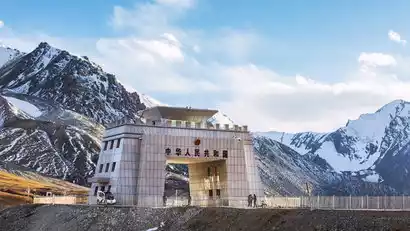
After breakfast, we will depart for the Khunjerab Pass. Khunjerab means "blood-stained passage" in Tajik. It is the highest national gate in my country. There are only more than 80 days of frost-free period a year. Even in summer, the top of the mountain is covered with snow.
·afternoon
In the afternoon, we visited the Wakhan Corridor, the "crossroads" between the four countries. This is a narrow strip of land between China, Afghanistan, Tajikistan and Pakistan, and is also a land route connecting China and Afghanistan.
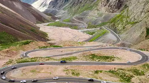
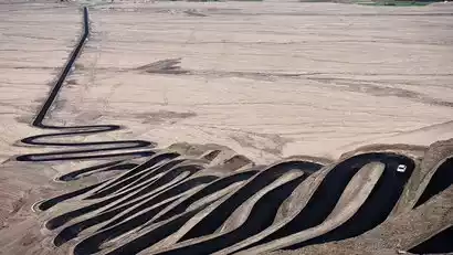
Head to southern Xinjiang's newly popular Panlong Ancient Road, a winding mountain road with 360-degree turns that leads directly to the summit. From the hillside, you'll enjoy panoramic views of the plateau. The road, just 30 kilometers long, features hundreds of twists and turns, embodying its slogan: "Today, having overcome all the twists and turns in life, life will be smooth sailing from now on."
Panlong Ancient Road Conditions Description:
The Panlong Ancient Road is at a high altitude, with steep terrain and many continuous bends. If the road is blocked by snow, it will occasionally be temporarily closed. If it is impossible to cross it, you will have to give up. Please understand.
Day 9: Tianta County → Taheman Wetland (Wetland Tour) → Tree Hole Highway → Glacier Park → Karakul Lake → Kashgar
·morning
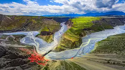
After breakfast, we departed for the Taheman Wetland. China-TravelNote arranged a special off-road vehicle tour, allowing us to explore the wetland up close and personal, admiring the snow-capped mountains and wetlands. Finally, we arrived at the private, hidden Tree Hole Road! The several-kilometer-long road was lined with uniquely plateau-growing trees, their branches connected at the top. Walking through the tree holes felt like traveling back in time.
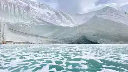
Our second stop is Muztagh Ata Glacier Park, where we can get up close to the "Father of Glaciers," Glacier No. 4 of Muztagh Ata (4,650 meters above sea level). This huge white glacier continuously nourishes the Palmy Plateau.
·afternoon
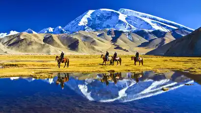
From Karakul Lake, you can admire the three majestic peaks of Kunlun: Kongur Peak (7,649 meters), Kongur Jiubie Peak (7,530 meters), and Muztagh Ata Peak (7,546 meters). The emerald blue glacial lake reflects Muztagh Ata, the "Father of Icebergs."
Arrive in Kashgar in the evening, and then stroll around this prosperous city in the western regions. At night, we will meet up to eat at the food street.
Day 10 Kashgar - Various locations (★Event end date)
All day
Today is the day when the event ends. Everyone will go to Kashgar Airport or Kashgar Railway Station according to their respective travel times and return to their warm homes.