Day 1 Various locations - Shangri-La★Assembly Day
All day
Today is a full-day assembly day, so team members please go to the hotel on their own.
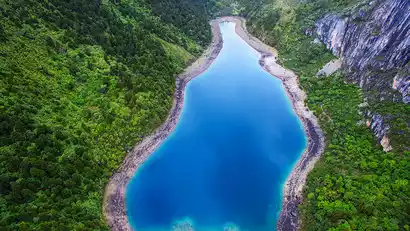
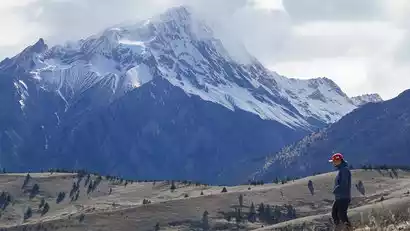
After checking in, you'll have free time at Dukezong Ancient Town and dinner. You'll be free to stroll through the ancient city of Dukezong, which boasts over 1,300 years of history. At Guishan Park, perched high above Dukezong, you'll find a massive, gilded copper prayer wheel (21 meters tall, weighing 60 tons, and a Guinness World Record entry). Join us in turning the wheel and chanting prayers.
You can also freely go to the Tibetan Buddhist temple [Songzanlin Temple] in Yunnan. Built on the mountain, Songzanlin Temple looks very similar to the Potala Palace. The unique five-story Tibetan carved architecture is a culmination of Tibetan plastic arts. It is also known as the "Tibetan Art Museum" and allows you to appreciate the profound Tibetan Buddhist culture.
How to get to Shangri-La
The meeting hotel is located in downtown Shangri-La, approximately 9km away from Shangri-La Airport and Shangri-La Station, a 20-minute drive away.
1. Direct flight to Shangri-La: For tourists with limited time, you can choose direct flight;
2. Transfer in Kunming: You can choose to transfer in Kunming, which saves both time and cost;
3. High-speed train from Kunming/Dali/Lijiang to Shangri-La: High-speed trains have been launched from Kunming/Dali/Lijiang to Shangri-La, with frequent departures daily. Please check the specific fares in real time.


Day 2 Shangri-La → Balagzong Back Mountain → Derong County
All day
Hiking Information
Hiking route: Xinantun Ranch (4086m) - Tsering Co (4160m) - Black Lake Ridge (4500m) - Tsering Co (4160m) - Visitor Center (3524m), about 12km
Hiking time: about 6 hours (altitude ascent of about 414 meters, descent of about 976 meters)
Luggage information: It is recommended to pack your luggage separately. Use an outdoor backpack to carry necessary items and supplies. Large luggage can be stored on the tour vehicle.
Meal information: There will be no supplies along the way, so you need to bring your own lunch
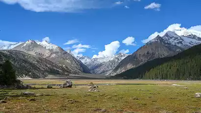
Behind the Balagzong Mountain, searching for the holy lake in the secret place
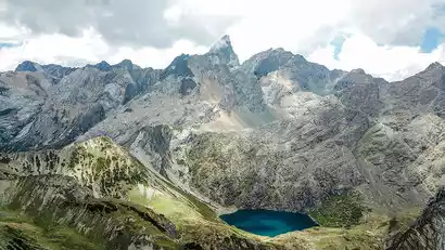
After breakfast, we'll depart for Sichuan at Benzilan, a key town on the Ancient Tea Horse Road. Arriving at Guxue Township, we'll continue our journey by car up the mountain to the back of Balagezong. Arriving at Xin'antong, we'll begin our hike. After a forested excursion, we'll reach Tsering Co., a narrow lake surrounded by sacred mountains. Prayer flags flutter beside it, and the water's color changes with the light of day. Continuing along the shores of Tsering Co, we'll pass Eagle Meadow and ascend a short distance to discover the deeper Black Lake. From the ridgeline, overlooking the lake, it resembles a dark green jewel set amidst the Balagezong Mountains.
Then we descended, passed Xinantun Ranch and entered the forest. In summer, the forest was lush and green, with various rhododendrons blooming in the forest. From July to August, various mushrooms under the forest gradually emerged from the ground. From October, the fir, birch and other trees began to change color, and the forest became colorful.
[Record filing instructions] If you are unable to go to Tsering Co due to force majeure factors such as landslides or policies, the record filing will be initiated: D2 Shangri-La - Bisang Valley Cuona Lake Hiking - Stay in Derong County, the hiking distance is about 13KM, the altitude is 3438m-3877m, and it takes about 6 hours. The subsequent itinerary remains unchanged and the fee is unchanged. Please understand.
Day 3 Derong County → Genyen Peaks Observation Deck and back → Zeba Village or Xiazetong Village
All day
Hiking Information
Hiking route: Starting point of the Genyen Peaks Observation Deck (3876M) - First Observation Deck (3936M) - Second Observation Deck (3946M) - Third Observation Deck (3975M) - Fourth Observation Deck (4007M) - Starting point of the Genyen Peaks Observation Deck (3876M), round trip about 6KM
Hiking time: about 4 hours round trip (altitude ascent and descent of about 131 meters)
Luggage Information: This is a round trip, so it is recommended that you carry essential items and supplies in a backpack. Large luggage can be stored on the vehicle.
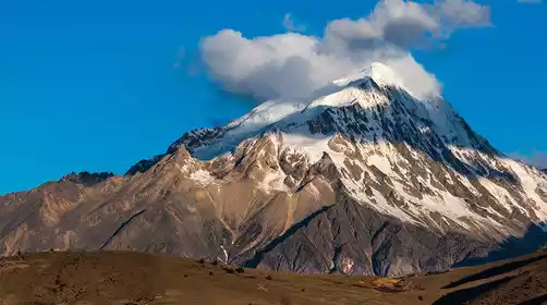
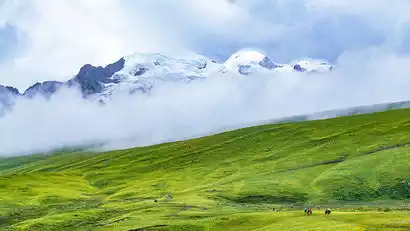
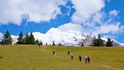
Heading north to Mount Genyen
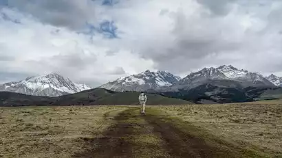
After breakfast, we'll depart. The scenery along the way gradually changes. The roadside villages are now dominated by white Tibetan houses, with willow branches swaying by the river. These white houses are nestled amidst lush green fields, with smoke rising from chimneys from time to time. Tibetan Buddhist temples occasionally appear along the roadside, embodying the idyllic imagery of Tibetan countryside. We'll stop at scenic spots along the way for photos and check-in. After passing through a dry, hot river valley, we enter a forested section, dotted with birch and maple trees. The valley is lush in summer and vibrant in autumn. Remarkably, the area is sparsely populated with vehicles and tourists, making for a fantastic road trip.
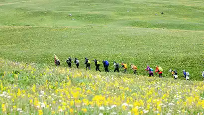
After crossing the Laozhelongba Pass, you will officially enter the southern line of Genyen. If the weather is good, the Genyen Sacred Mountain, Xiaxiong, Xiachun and other snow-capped mountains will appear before your eyes. Continue forward and you will overlook the Redi River Valley. After reaching the bottom of the valley, follow the river towards Litang. Along the way, you will pass by large and small nameless flower fields, and the village is surrounded by flower fields. There are pastures and rivers between the snow-capped mountains and the village, as if you have arrived in a fairyland.
The Genyen Peaks Observation Deck offers a wide-angle view of the snow-capped mountains.
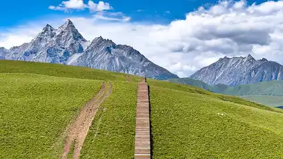
Upon arrival in Genyen, we'll first reach the Genyen Peaks Observation Deck. Then, we'll follow the paved plank path deep into the grasslands. If the weather is clear, looking back, we'll see the seven main snow-capped mountains of Genyen lined up above the meadows, their soft lines outlined by the sunlight. Below the snowline, the austere rocks rise like ice cream, their snowy tops a spectacle. Wild rabbits scurry across the meadows near the plank path. From July to August, a vibrant array of wildflowers blooms across the grasslands. In early October, the birch trees in the distant forests begin to turn red. The scenery is breathtaking, reminiscent of both Xinjiang and Switzerland. Continuing along the plank path, we'll overlook the Eye of Genyen and the Diqu River Valley, transforming the path into a truly stunning sight.

Day 4 Zeba Village or Xiazetong Village → Eye of Genyen → Xiaozha South Slope → Lengda → Zeba Village or Xiazetong Village
All day
Hiking Information
Hiking route: Eye of Genyen (3868m) - River Valley (3763m) - Ridgeline (4203m) - Lengda (3773m), about 12km
Hiking time: about 7 hours (altitude ascent of about 440 meters, descent of about 335 meters)
Luggage information: It is recommended to pack your luggage separately. Use an outdoor backpack to carry necessary items and supplies. Large luggage can be stored on the tour vehicle.
Meal information: There will be no supplies along the way, so you need to bring your own lunch
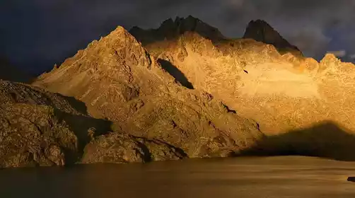
Waiting for the sun to shine on the golden mountain of Genyen and feeling the holiness of the snow-capped mountains
Rise early and wait for the golden sun to shine on the mountain. On a perfect day, golden light bathes the snowy peaks of Mount Genyen, radiating a dazzling pink or golden hue. (Autumn and winter, with less rainfall, offer a higher chance of golden light.) Combined with the changing light on the pastures below, this creates a visual feast.
Hiking on the south slope of Xiaoza, viewing the snow-capped mountains from different angles
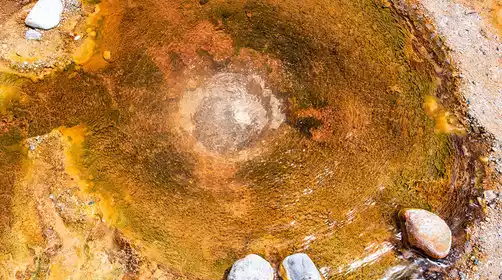
After breakfast, we'll head to the Eye of Genyen. This natural pool, nestled among the Genyen Mountains, features a circular ring of waterweed, resembling the pupil of an eye, gazing out across the vast expanse of the sky. After a brief stop at the Eye of Genyen, we'll officially begin our hike. We'll enter a vast meadow, where we'll ascend gently for a short distance before descending into a river valley. After crossing the valley, we'll climb a short distance to reach a stretch of pasture. Wildflowers bloom in summer, and birch forests turn yellow in autumn. Reaching the ridgeline, snow-capped mountains loom to our right, with Genyen and Xiaozha within sight. We'll traverse forests, river valleys, and grasslands, taking in the scenery and strolling along the way until we meet our vehicle near Lengda.
Day 5 Zeba Village → Xinleng Ancient Temple → Yikeshu → Zeba Village or Xiazetong Village
All day
Hiking Information
Hiking route: Xinleng Ancient Temple (3880m) - Forest Pass (4030m) - River Valley (3983m) - Glacier Ridge (4434m) - One Tree (4238m) - Hiking Tree (4090m) - Zeba Village (3800m), about 14km
Hiking time: 7-8 hours (altitude ascent of approximately 554 meters, descent of approximately 634 meters)
Luggage Information: No need to pack large luggage for two consecutive nights. You can carry necessary items and supplies in a backpack and leave large luggage at the inn.
Meal information: There will be no supplies along the way, so you need to bring your own lunch
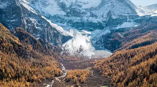
The essence of Genyen C line, looking at a tree and a glacier
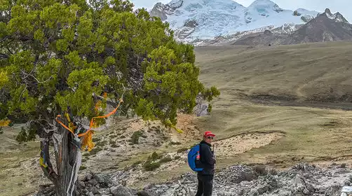
Today, we'll be free to wake up early to watch the sun set over the Golden Mountain. After breakfast, we'll head to our starting point, Xinleng Ancient Temple. Nestled at the foot of Mount Genyen, the temple houses three treasures: a doe's antler, an inverted conch shell, and the Heart of Genyen. After a warm-up, we'll depart and journey into a primeval forest filled with towering trees draped in lichen. As the light of day shimmers through the forest, we'll begin our hike. Upon exiting the forest, we'll reach a grassland. The first sight is the remains of Karma Kagyu Monastery, with its broken walls and snow-capped mountains looming in the background. We'll then ascend to the ridgeline. To the left, we'll find a vast expanse of grassland brimming with wildflowers. To the right, we'll see Mount Genyen, with the shimmering glaciers soaring close by. Take your time, admire the flowers, and take photos with the glacier.
After a short hike along the ridgeline, we'll turn back and descend to the "One Tree" site, a famous spot for its photogenic beauty. A solitary cypress tree stands tall above the grassland, with the main peak of Genyen and the glacier in the background. Many people come here specifically to take photos. After a brief pause, we'll continue downhill to Zeba Village. Along the way, we'll pass the "Hiking Tree," a slightly different structure with mani piles piled beneath it. Here, we can also take photos with Mount Genyen and the glacier. Here, we'll part ways with the path to Handa Camp and continue south, descending a small hillside to Zeba Village.
Day 6: Tianzeba Village → Starting point of the Hamda Trek → Daodao River Valley → Reti River Valley → Bomi Township
All day
Hiking Information
Hiking route: Starting point (3955m) - Ridgeline (4427m) - First Pasture (4336m) - First Pasture Ridgeline (4379m) - Second Pasture (4240m) - Top of the Wetland (4340m) - Daodao River Valley (4210m) - Valley Ridge (4291m) - Reti River Valley (4092m), about 14km
Hiking time: 7-8 hours (altitude ascent of approximately 472 meters, descent of approximately 335 meters)
Luggage information: It is recommended to pack your luggage separately. Use an outdoor backpack to carry necessary items and supplies. Large luggage can be stored on the tour vehicle.
Meal information: There will be no supplies along the way, so you need to bring your own lunch
Face the southern slope of the Genyen Glacier and admire the beautiful island valley
After breakfast, we'll be transported to the hiking starting point. Entering the forest, we'll begin a gentle ascent. Today's climb will be long, taking about three hours to reach the ridgeline, but the scenery is breathtaking. After emerging from the forest, we'll begin our journey through meadows, where colorful flowers sway in the breeze. The sacred Mount Genyen stands as a constant companion. Upon reaching the ridgeline, we'll be greeted by a sweeping view of the glaciers on the southern slopes of Genyen. We'll then follow the contour lines, passing several rivers, alpine wetlands, and pastures, offering a wealth of scenery. Reentering the forest, we'll descend and arrive at the Daodao River Valley. Here, the river nourishes the valley's wetlands, where horses, cattle, and sheep graze leisurely. Fir trees line the wetlands, and deep within the valley, the snow-capped mountains of Genyen, Xiaxiong, and Xiachun converge, creating a breathtakingly beautiful scene. After crossing the ridge adjacent to the Daodao River Valley, we'll overlook the Redi River Valley. The winding river flowing through the relatively wide, flat meadows offers another breathtaking view.
After getting off the road, we took a bus to Bomi Township to prepare for tomorrow's Co Niang Ka hike.
Day 7: Tianbomi Township → Alpine Pasture → Luocuoren → Cuoniangka → Alpine Pasture → Derong County
All day
Hiking Information
Hiking route: Alpine Pasture (4450m) - Luocuoren (4676m) - Stonehenge (4700m) - Cuo Niang Ka (4760m) - Alpine Pasture (4450m), about 12km
Hiking time: about 6 hours (306 meters of ascent and 306 meters of descent)
Luggage information: It is recommended to pack your luggage separately. Use an outdoor backpack to carry necessary items and supplies. Large luggage can be stored on the tour vehicle.
Meal information: There will be no supplies along the way, so you need to bring your own lunch
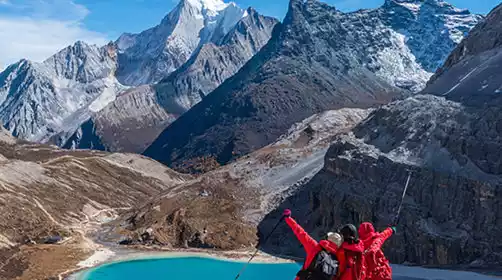
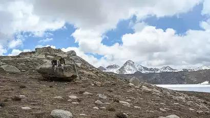
Hiking to Cognakkar and seeing the reflection of Mount Genyen
Today, we woke up, packed, and after breakfast, drove to the starting point of the alpine pasture hike. Co Niang Ka is approximately 4,760 meters above sea level. To save energy, we drove directly to the alpine pasture at 4,450 meters. We then began our small loop hike, climbing gently for about 100 meters until we reached the edge of Luocuo Ren. Nearby lakes are dotted with numerous lakes, Luocuo Ren being the largest. Its deep blue waters reflect the mountains, and boulders, pushed forward by ancient glaciers, are scattered around the lakeside. We paused briefly for photos before continuing along the contour line toward Co Niang Ka. Along the way, we'll pass wetlands covered in taro and wild onions, boulders, and peaks reminiscent of Middle-earth. Finally, after about 1 kilometer through the wetlands, we arrived at Co Niang Ka Lake. On a clear day, the clouds above Mount Genyen are reflected in the lake, a scene that brings a sense of tranquility.
We descended at the right time and met up with the convoy at the alpine pasture, then set off for Derong County to check in. We took a good shower and had a comfortable sleep tonight.
Day 8 Derong → Shangri-La★ Disbandment Day
All day
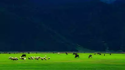
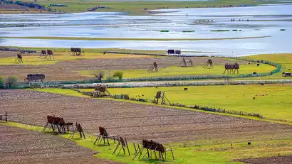
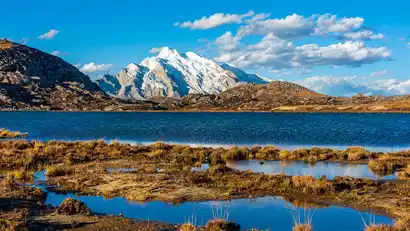
Napahai Essence Surrounds the Lake and Experiences the Ecological Beauty of the Plateau Wetlands
After breakfast, we will depart for Shangri-La at an appropriate time. Upon arrival in Shangri-La, we will take a short drive along the Napahai Ring Road, then head to the Napahai Observation Deck to overlook the entire Napahai and Yila Grassland. In spring and summer, you can see the vibrant plateau meadows with cattle and sheep leisurely grazing. In autumn and winter, Napahai is the habitat of many migratory birds, giving you the opportunity to observe these plateau elves from afar.
The meeting will then end at Shangri-La, with several disbanding points set up:
The tour will arrive at Shangri-La Station at approximately 13:00, Shangri-La Airport at 13:30, and will be dispersed near Dukezong Ancient Town at 14:00. Tourists returning on the same day are advised to book flights after 15:30 or trains after 14:00.