Day 1 Suzhou → Jiaxing Haiyan Gaoyang Mountain → Nanbei Lake Scenic Area → Suzhou
07:00
Meeting Point 1 07:00-07:10 (10 minutes to sign in, please do not be late), intersection of Jintang Street and Zongguantang Road (near Exit 6 of Pinghe Road Station on Metro Line 2. Cars can park at Yaosheng Building, capped at 20 yuan/day)
Meeting Point 2 07:30-07:35 (5 minutes to get on the bus, don't be late), Suzhou City Toll Station (G1522 Changtai Expressway Entrance), 200 meters south, waiting under the elevated road (if you drive, you can park at Huadong Decoration City, the maximum fee is about 25 yuan/day)
Meeting Point 3 07:55-08:00 (5 minutes to get on the bus, don't be late), Metro Line 4 - Wujiang Bus Station - Exit 2 (free parking nearby for self-driving cars, paid parking lots are also available, capped at 30 yuan/day)
After signing in, we set off on the highway. The team leader led the interaction, introduced himself and explained the itinerary, and we laughed and laughed all the way to our destination.
10:00
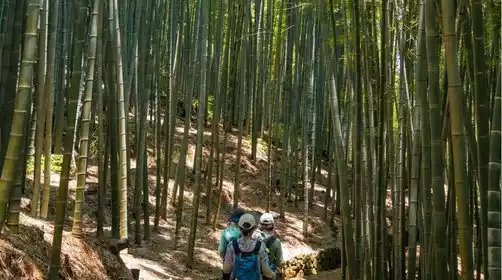
We got off the highway and headed to the starting point for the hike. After warming up, we began our hike up the mountain. Although the climb was long, the trail was well maintained and relatively accessible.
We arrived at Ziyun Mountain around 10:30, walked down a steep slope and came to a country road.
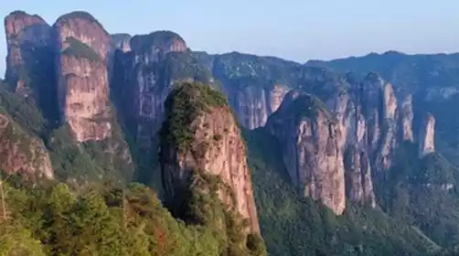
Afterwards we went up Gaoyang Mountain, which is the first section of the Slope of Despair. The Slope of Despair is daunting because you can see from the bottom of the slope to the top, and you can't help but feel that the journey is long and difficult.
12:30
Arriving at Gaoyang Mountain, there is a national surveying sign where everyone can enjoy lunch and take group photos.
After descending Gaoyang Mountain, you will cross a section of hollow iron stairs. Please watch your steps carefully and don't step on the wrong one.
1:30 PM
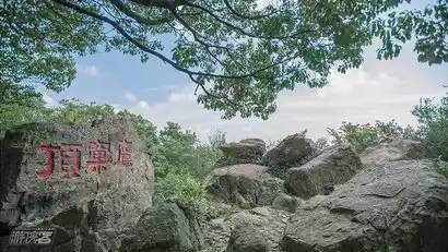
Everyone rushed to the top of Eagle's Nest Peak, which is the second section of Despair Slope. This Despair Slope is not as clear and straight as Gaoyang Mountain, but it is winding and tortuous. There are many forks on the mountain. Pay attention to follow the leader or observe the road signs carefully.
Yingke (yingke) originally refers to an eagle's nest, and Yingkeding (yingkeding) refers to a mountaintop where many eagles' nests are located. Here, you can look up to see if there are eagles soaring...
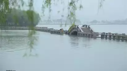
We arrived at Nanhu Lake around 14:00, where the blue waves were rippling and the beautiful scenery was in full view.
4:30 PM
We walked to the end of the hike near Beihu Lake and strolled around the center of the North and South Lakes. This section of road is about 2 kilometers long. After arriving at the end, we made some adjustments and got on the bus to return to Shanghai.
We returned to the starting point in Suzhou around 19:00. We were reluctant to leave, kissed goodbye with tears in our eyes, and agreed to meet again next time!!!
This route is a fast entry route. The route is in relatively good condition and has many drop-off points. It is the best choice for a fast entry route! !
There will be slight adjustments to the closing points in autumn and winter, and the specific details will be announced by the tour leader on the day!
7:00 PM
Returning to the starting point in Suzhou, everyone was reluctant to leave, kissed goodbye with tears in their eyes, and made plans to meet again next time!!!
Tips: This route is a fast entry route. The route is in relatively good condition and has many drop-off points. It is the best choice for a fast entry route! !
There will be slight adjustments to the closing points in autumn and winter, and the specific details will be announced by the tour leader on the day!