Day 1 Various locations → → Lhasa ★ Gathering day
All day
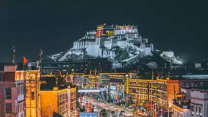
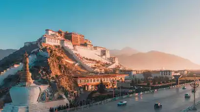
Today is a full-day gathering day. Everyone will travel to Lhasa by their own means of transportation. Upon arrival at the meeting hotel, please provide "China-Travel Note + Name" to check in. Don't get too excited when you first arrive in Lhasa. Eat plenty of fruit and rest frequently to quickly acclimate to the plateau climate. Tourists arriving early, if their health permits, may explore the area around the Potala Palace and Barkhor Street for creative work. As this activity takes place entirely at high altitude, it is strongly recommended that participants arrive in Lhasa early to acclimate and minimize the effects of altitude sickness.
Arriving in Tibet by plane: Meet at the designated hotel in Lhasa for the day to acclimate to the plateau climate. If you feel unwell, please contact the tour leader and guide immediately for assistance. When you first arrive at the plateau, drink plenty of water, eat some fruit, and get some rest later (going to bed early will cause you to wake up in the middle of the night and have difficulty falling asleep).
Train to Tibet: Take a sleeper train along the Qinghai-Tibet Railway, enjoying stunning photography of the plateau's magnificent scenery. (After Golmud, you'll officially enter the plateau. Snow-capped mountains, pastures, Tibetan antelopes, yaks, and more offer excellent photo opportunities. If you're in the right time, you'll also have the opportunity to capture the breathtaking sunrise and sunset. Arrive in Lhasa, the terminus of the Qinghai-Tibet Railway, in the evening and transfer to your hotel.
Border Pass Related (Must Read)
There are many border checkpoints in Ngari Prefecture. Currently, the document processing hall is mostly used by individual tourists. Group tourists still need to go to the window to process in their own name, which can lead to long queues. In serious cases, it may affect the itinerary. Therefore, tourists are required to apply for a border pass in advance at their registered residence or place of residence, and then go to the nearby police station to provide their second-generation ID card. The pass is usually issued on the spot (subject to the processing time of the police station).
Reason for travel to Tibet: Fill in “tourism”.
Destination: Tibet Autonomous Region, Shigatse Prefecture, Ngari Prefecture (Must be typed, handwritten is not valid!!)
Day 2 Lhasa → Yamdrok Lake → Manla Reservoir → Shigatse
·morning
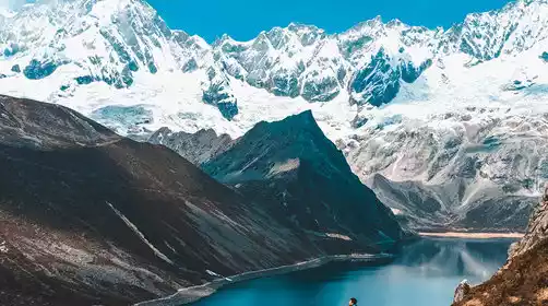
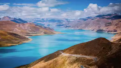
After breakfast, we'll depart and cross the 4,990-meter-high Gangbala Mountain to Yamdrok Lake, one of the three sacred lakes, for photography. Yamdrok Lake, known in Tibetan as "Jade Lake," boasts waters as clear as goat fat. Against the backdrop of blue skies and white clouds, we'll choose the perfect camera position for scenic photography. The azure waters merge seamlessly with the distant snow-capped mountains. The vibrant mountains on both sides, the distinctive Tibetan villages, and the abundance of cattle and sheep create a perfect backdrop for scenic photography. We'll stop at two or three locations along the way to capture the beauty of Yamdrok Lake from various angles.
·afternoon
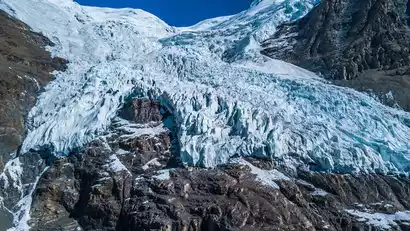
In the afternoon, we passed by the filming location of "Red River Valley" [Karuola Glacier] and stopped for a while to take photos.
We then continued on and stopped at the Manla Reservoir to take some photos. This was once a village, but it was submerged after the reservoir was filled with water, leaving only the ruins of a temple standing between the mountains and the water.
·night
Arrive in Shigatse, a major city in western Tibet, and check in in the evening. (Ngari is a vast area and the drive is long. The photography group will stop along the way for filming, so we will arrive at the hotel late each day. Please be prepared for this.)
Day 3 Shigatse → Tashilhunpo Monastery → Langcuo → Saga
·morning
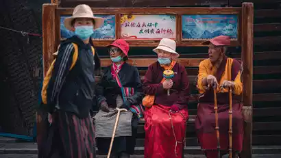
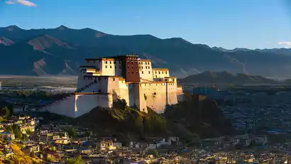
We got up early in the morning and, under the guidance of our team leader, headed to the prayer path on the back mountain of Tashilhunpo Monastery to take panoramic photos of the monastery and freely capture the Tibetan people's culture while they were circumambulating the temple.
·morning
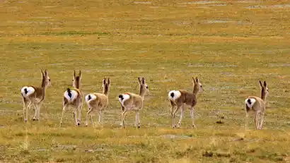
Leaving Shigatse at the right time, we arrived in Lhazi County, home of Tibetan knives. The grassland scenery was breathtaking along the way. When you see the 5000 sign for Sichuan-Tibet Highway 318, it means you're nearing the end of the route. Along the way, we began to encounter black-necked cranes and Tibetan wild donkeys. We also discovered a new, lesser-known spot along the way: Langcuo (a place perfect for drone photography).
·afternoon
Continue to Saga and stay overnight. Saga is a small town that many Indian believers stay in during the pilgrimage to Mount Kailash. It is also the starting point of the southern route to Ngari.
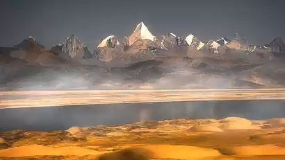
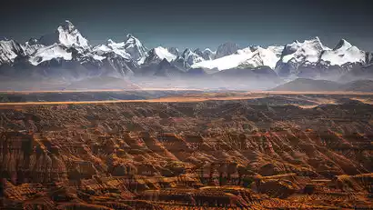
Day 4 Saga → Payang Sand Dunes → Mayumula Pass → Laang Co → Tachin
·morning
After breakfast, we'll depart westward to Payang Town, a grassland town steeped in Western charm. Along the way, we'll be greeted by golden sand dunes, a magnificent sight set against the backdrop of snow-capped peaks and blue skies. Along the way, we'll photograph the Zhongba Sand Dunes. The nearby dunes echo the distant snow-capped mountains, creating a desolate, majestic, and tragic scene, captivating a captivating wild beauty.
·afternoon
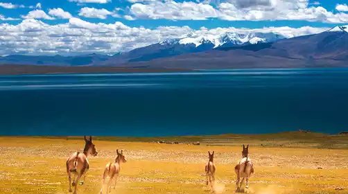
Then, we crossed the Mayumula Mountain Pass at an altitude of 5,211 meters. The river valleys before and after the pass are where Tibetan wild donkeys and Tibetan antelopes gather. I wish we were lucky enough to encounter and take pictures of them on this trip.
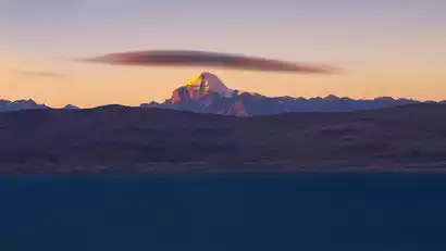
In the afternoon, we went to the ghost lake Laang Co to photograph the sunset. The sunset camera here is a good location to photograph the sunset over Mount Kailash, with the lake in the foreground and the sacred mountain in the background, which is rich in layers.
·night
After the sunset photoshoot, we drove to Tachin to check in.
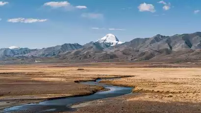
Day 5 Tachin → Kailash → Zada Earth Forest → Zada
·morning
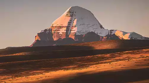
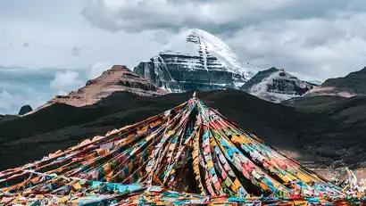
This morning, we were treated to prime photography opportunities at Mount Kailash. At sunrise, the clouds and winds swirl, creating an endless tapestry of light and shadow, each minute presenting a different scene of breathtaking beauty. The lake is known as a sacred lake not only because of Tibetan religious beliefs but also because of its unpredictable nature. We took our cameras and gazed directly upon the most breathtaking sacred mountain scenery in Tibet.
·morning
Depart for Arizada at the right time, enjoying the scenery of snow-capped mountains and grasslands along the way.
·afternoon
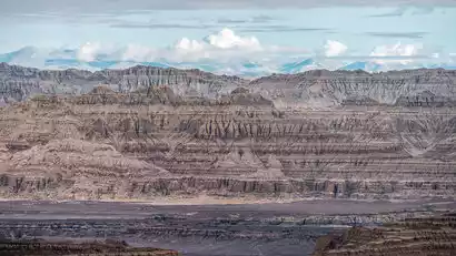
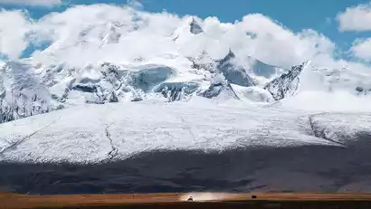
In the afternoon, we arrived at the Zada Earth Forest to explore and photograph its varied formations, rising dozens of meters in height. In the distance, the snow-capped peaks of the western Himalayas loomed, with the towering Kalmet Peak towering behind them. From the observation deck, we captured the stunning harmony of the earth forest and the snow-capped mountains. In the evening, we arrived in Zada County and checked in.
Day 6: Full-day photography in Zhada (Guge Dynasty + Xiayi Valley)
·morning
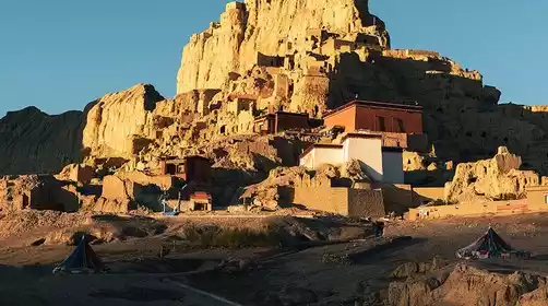
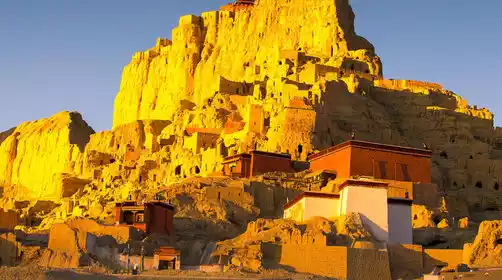
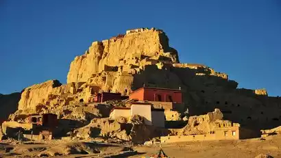
Get up early and head to Guge Kingdom, where you'll transfer to a scenic shuttle bus to capture the morning scenery. The Guge Kingdom, once a flourishing empire and the birthplace of the ancient Ngari civilization, suddenly vanished without a trace around the 17th century, leaving behind only a few records and various mysterious legends.
·morning
We left at the right time and returned to Zhada County to rest.
·afternoon
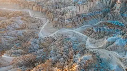
In the afternoon, we drove to Xiayigou, deep within the Zada Earth Forest National Geopark. This is a breathtaking site that even Ali locals rarely get to see! From top to bottom, the soil in Xiayigou varies in color, from silver, white, brown, and earthy tones. The bizarre and rugged rock formations fill the landscape. As we took photos, we marveled at the wonders of nature.
Kind tips:
A new sightseeing plank road has been built in Xiayigou this year. After getting off the scenic bus, you need to walk about 800m (1.6km round trip) to the interior for shooting. The plank road is generally smooth and easy to walk, but at an altitude of about 4,300mi, it is recommended to travel as light as possible.
After the shoot, we returned to the hotel to have a good rest.
Day 7 Zhada → Malang Canyon → Lake Manasarovar → Tachin
·morning
After breakfast, we left Zhada and walked into the Malang Canyon via the Xiangxiong Ancient Road (this place is suitable for drone photography).
·afternoon
Then we left and arrived at the Manasarovar Observation Deck to capture the glorious sunset of Mount Namuani, the "Fifth Goddess of the Himalayas".
After enjoying the photoshoot, we arrived at the Tachin Hotel and checked in.
Day 8 Tachin → Mount Kailash → Kongzhutso → Saga
·morning
We got up early this morning and came to a niche camera position to shoot the sunshine scene with Mount Kailash and the canal in the foreground. When the golden hour ended, we drove away and stopped to shoot at Gongzhucuo.
·afternoon
We then crossed the Mayumula Pass at an altitude of 5,200 meters and continued on through Payang Town, where Tibetan houses with a distinct ethnic charm are scattered throughout. We continued along the asphalt road to Zhongba County and the Zhongba Sand Dunes (if you didn't shoot on Day 4, you can plan to do so today). In the distance, you can see the Maquan River, the upper reaches of the Yarlung Zangbo River.
Overnight in Saga.
Day 9 Saga → Pegu Co → Everest Base Camp → Everest Village
·morning
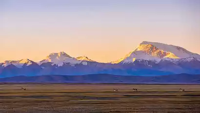
We set off today and passed by Peigucuo to take pictures of Shishapangma Peak. Shishapangma is 8,012 meters above sea level and is known as the "auspicious sacred mountain". It is an 8,000-meter peak located entirely in China.
·afternoon
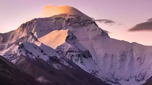
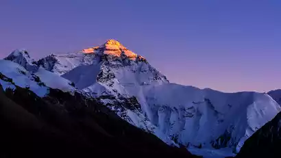
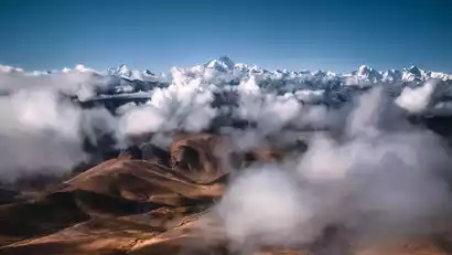
Then we will enter the [Everest National Park] and the car will climb the layers of Mount Everest Road. We will lead you to the Gaulha Pass. When the weather is good, you can see four 8000m+ Himalayan snow peaks in one breath: Makalu (8463m), Lhotse (8516m), Mount Everest (8848m), and Cho Oyu (8201m). It is very photogenic!
We arrived at the Everest Base Camp at the right time. This is also the location for photographing Mount Everest. It is very suitable for creating sunsets on the snow-capped mountains. The biting cold wind and the lonely Mani piles made us quietly wait for the sunset on Mount Everest.
After taking photos of the sunset, we headed to the foot of Mount Everest to check in.
Day 10: Mount Everest Village → Gawu La Pass → Tashilhunpo Monastery → Shigatse
·morning
Before dawn, the Everest Village was bathed in a cold sky. We donned all our warm clothes and braved the fierce wind, fully geared up to reach Gaulha Pass before sunrise. From there, we photographed the sunrise over several snow-capped peaks over 8,000 meters: Makalu, Lhotse, Everest, and Cho Oyu.
·afternoon
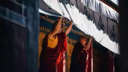
Afterwards, we'll travel to Shigatse and visit Tashilhunpo Monastery for photography. Tashilhunpo Monastery is one of the six major monasteries of the Gelugpa sect of Tibetan Buddhism and the seat of the Panchen Lama. Its sprawling architecture and the large number of Tibetan pilgrims make it a great place for architectural and cultural photography. While photography of the architecture and cultural heritage is permitted within the monastery, please observe monastery regulations, refrain from photography, and listen attentively to your guide's explanations while inside the halls.
After the photo shoot, we checked into the hotel in Shigatse city.
Day 11 Shigatse → Lhasa ★ Disbanding day
All day
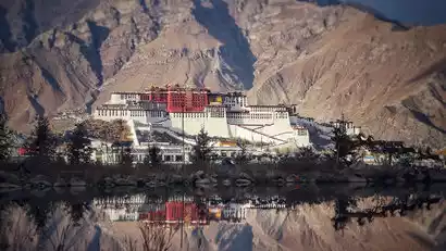
After breakfast, we'll drive along the Yarlung Zangbo River to Lhasa, first dropping us off at Lhasa Airport and then passing by Lhasa Railway Station. Tourists not returning today can return to Potala Palace Square for the day's tour.
With this, our 11-day photography trip to Ngari has come to a successful conclusion. It is time to say goodbye to each other and make plans for the next trip.