Day 1 Various locations → → Lhasa ★ Assembly day
All day
Today is an all-day assembly day. Each team member will arrive in Lhasa according to their own means of transportation and check into the hotel on their own.
After checking in, tourists are advised to rest and acclimate to the plateau to prepare for the rest of the trip. Tourists in good physical condition can go for a walk in Barkhor Street. It is recommended to slow down on the plateau.
The tour leader will hold a pre-trip meeting in the evening to explain the itinerary, hiking route, precautions, and check equipment. Please do not miss it.
Border Pass Application → This itinerary requires a border pass. Please fill in "tourism" for the purpose of entry into Tibet and "Xigaze Prefecture" or "Shannan Prefecture" for the region.
The guide to applying for a border pass is here, and you can apply for it in the following ways
1. Bring your ID card and a 1-inch photo and go to the police station/administrative center where your household registration is located (or have a relative handle it on your behalf) to handle the matter!
2. If your registered residence is unable to obtain a border pass, you can bring your border pass application form to the local police station for stamping. Then, apply at the visa office in the Lhasa Border Defense Building one day in advance. Weekday processing hours are 9:30 AM to 5:50 PM, with no lunch break; weekend and holiday processing hours are 9:30 AM to 12:20 PM. On weekends, it is recommended to arrive one hour before closing time. Please provide your email address when registering, and we will send you the border pass application form.
Day 2 Lhasa → Yamdrok Lake → Phumoyu Lake → Lhodrak
All day
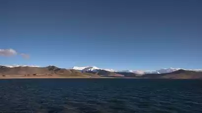
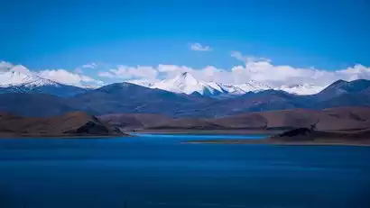
After breakfast, we crossed the Gangbala Pass and arrived at Yamdrok Lake, one of Tibet's three sacred lakes. The crescent-shaped bay, the azure waters, and the one or two high points overlooking the sacred lake are all so beautiful.
We will continue on our journey, passing through Pumoyongcuo and Mondala Pass, and finally arrive at Lhozhag County. We will stay in Lhozhag County tonight.
Day 3 Lhoza → Parking lot (4520m) → Baima Lincuo Observation Deck (4690m) → Parking lot → Cuoyu Village
All day
-Hiking distance: about 3km one way, about 6km round trip
-Cumulative elevation: +300M/-300M
-Hiking time: about 4 hours
-Supplies along the way: None
-Road conditions: Dirt road with gentle slopes
After breakfast, take a bus from Lhoza to the starting point of the hike - [Bai Ma Lin Cuo Parking Lot], and hike back and forth via the Bai Ma Lin Cuo Viewing Platform.
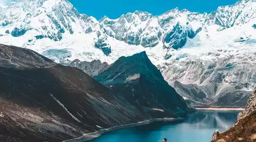
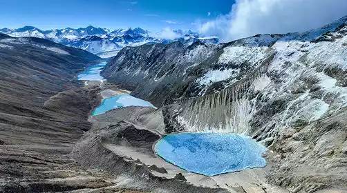
Baima Lincuo, also known as Zhongcuo Baima Lin, is said to be one of the three spiritual lakes of Guru Padmasambhava. The lake's varying shades of blue, green, and white blend with the surrounding scenery. Each season offers a different experience at Baima Lincuo, from the vibrant flowers of summer to the vibrant colors of autumn and the snow-covered, frozen lake of winter. The enchanting scenery is truly captivating.
After the hike, we will drive back to Cuoyu Village for accommodation.
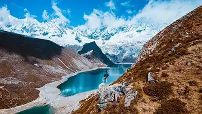
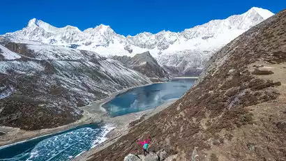
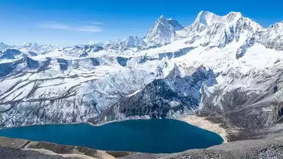
Day 4: Cuoyu Village → Parking Lot → Zhegongcuo Three Gods Lake (5050m) → Parking Lot → Cuoyu Village
All day
-Hiking distance: one way about 6.5 km, round trip about 13 km
-Cumulative elevation: +530M/-530M
-Hiking time: about 8 hours
-Supplies along the way: None
-Road conditions: Dirt road with gentle slopes
After breakfast, take a bus from Cuoyu Village to the starting point of the hike - Baima Lincuo Parking Lot. Climb along the valley path on the right to the [Zhegongcuo Three Gods Lake] Pass.
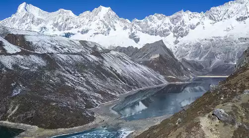
Arriving at the pass, you can overlook the three sacred lakes of Zhegongcuo, which are arranged in a row, like three clear sapphires inlaid in the middle of the Himalayas. Directly above is the majestic Kolhakar - 6479m.
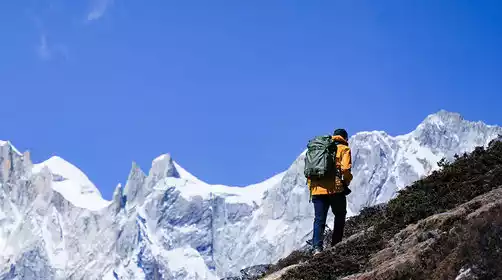
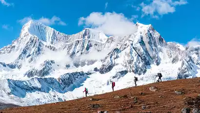
Today's hike is mainly uphill, with a high altitude. Please proceed according to your ability. If you feel tired, you can retreat at any time. After everyone arrives, we will take a bus back to Cuoyu Village to rest.
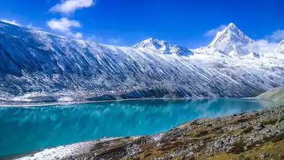
Day 5: Cuoyu Village → Parking lot → Pass (4730m) → Jiejiucuo (4830m) → Parking lot → Pumoyongcuo → Langkazi
All day
-Hiking distance: about 3km one way, about 6km round trip
-Cumulative elevation: +300M/-300M
-Hiking time: about 4 hours
-Supplies along the way: None
-Road conditions: Dirt road with gentle slopes
After breakfast, we'll drive from Cuoyu Village to the Baimalincuo parking lot, the hiking starting point, and head towards Jiejiucuo. After a short uphill hike to the pass, we'll overlook the beautiful Jiejiucuo, nestled against the majestic Kulagangri Snow Mountain Range. Jiejiucuo is a long, narrow lake, and in winter, it's possible to walk through it. The hillside next to Jiejiucuo is a well-known vantage point for viewing Kulagangri (7,538 meters) and Karejiang (7,221 meters).
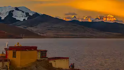
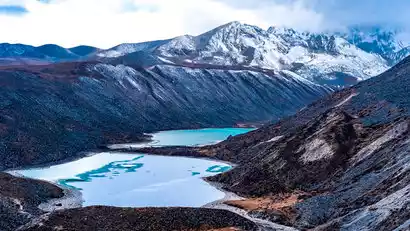
Return to the Baimalincuo parking lot and drive over the Mundala Pass for a close-up view of the magnificent Kula Kangri peaks: Kula Kangri (7538m), Kula Kangri II (7418m), Kula Kangri III (7381m), Karezhan (7221m), Karezhan II (7018m), and Karezhan III (6824m). Passing by Pumo Yongcuo, Pumo Yongcuo was featured in the NHK documentary "Pumo Yongcuo in the Sky" and also appeared several times in the documentary "The Third Pole." The lake, at an altitude of 5010 meters, is located on the border of Lhozhag and Nagarze counties in Shannan Prefecture. "Pumo" means "little girl," and "Yongcuo" means "jade-like lake." Legend has it that Pumo Yongcuo was blessed by Guru Padmasambhava, giving it a sacred aura.
Go to Langkazi County to stay and rest at the appropriate time.
Day 6 Langkazi → Lhasa ★ Disbandment Day
All day
Today's itinerary is relatively relaxed. We will follow the route around Yanghu Lake and go to Lhasa Airport for drop-off (arrive at the airport at around 12:00, it is recommended to choose a flight after 14:00), then take a bus back to Lhasa city to disband (near the White Pagoda of the Potala Palace, arrive at around 13:30, it is recommended to buy a train after 14:30), and the trip ends.