Day 1: Anywhere → or → Golmud ★Gathering Day
All day
Today is the all-day gathering day in Golmud. You can go there according to your own time and transportation. You can rest in the hotel after arrival. Please pay attention to the safety of your personal belongings during free time.
In the evening, a pre-trip photography meeting will be arranged at the hotel. Tourists will gather together to learn about the itinerary, shooting techniques and precautions. After that, they can talk freely. In the next few days, all tourists will be like a family!
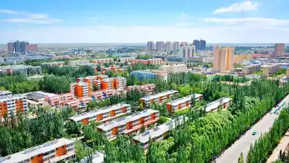
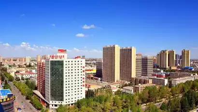
Golmud, nestled in the heart of the Qinghai-Tibet Plateau, is the plateau's third-largest city. Unlike the Gobi Desert in more remote areas, Golmud's urban area is a verdant oasis nestled in the desert sands. The city is shaded by trees and blooming with flowers, while the suburbs boast lush farmland and rows of trees.
Day 2 Golmud → Hoh Xil → Kunlun Pass → Sonam Darje Nature Reserve → Golmud
·morning
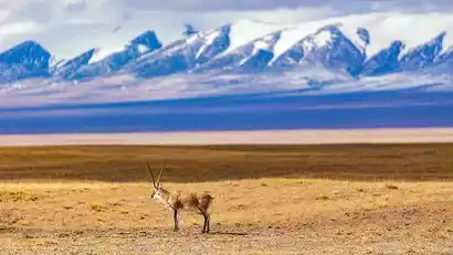
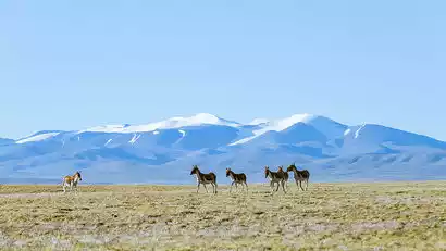
On the first day of the trip, we started our photography tour in the uninhabited area of Khekexili. Along the way, we will pass by areas with dense wildlife activities, and we can use a telephoto lens to photograph the wildlife along the way.
·afternoon
We'll then drive over the Kunlun Pass (4,776 meters, the highest point of the entire journey) to the Sonam Dargye Nature Reserve. We'll continue along the Qinghai-Tibet Highway, photographing Yuzhu Peak (6,178 meters) directly from Xidatan. Along the way, we'll have the opportunity to encounter and photograph various wildlife, including Tibetan sheep, wild donkeys, foxes, and, of course, the much-desired Tibetan antelope! At the Kunlun Pass, we'll see the Hoh Xil Tibetan antelope sculpture and the Sonam Dargye Monument.
After a full day of travel and photography, we stayed in Golmud that night.
Description of the Hoh Xil section: The Golmud-Sonam Darje Nature Reserve section is under repair in 2025, and the road conditions are bumpy. Please be mentally prepared. In the event of road closures for construction or other force majeure factors that make the road inaccessible, we will instead go to the Queen Mother of the West's Yaochi for filming and sightseeing.
Day 3 Golmud → Qarhan Salt Lake → Water Yadan
·morning
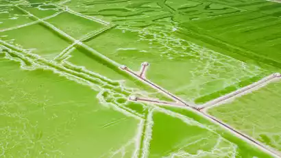
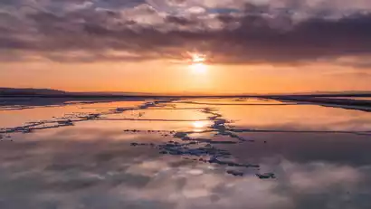
After breakfast, we set out to shoot the Qarhan Salt Lake. When the weather is fine, the vast lake is like a huge mirror, radiating silver light, steaming, and sparkling, just like a vast blue ocean.
Then turn onto National Highway G315 and drive off-road deep into the heart of the Qaidam Basin, passing by to photograph the Red River Valley. It is recommended to use a drone here to overlook the "blood of the earth" from an aerial perspective.
·afternoon
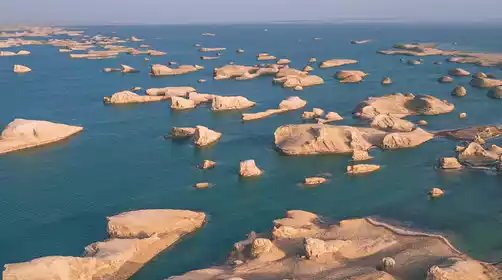
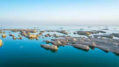
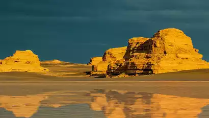
Later, we arrived at the Water Yadan. The remaining ruins, eroded by years of wind and rain, resembled a group of whales swimming at sea, their backs exposed, a force that resembled a thousand ships launching simultaneously! The tall "whale's back" on the lakeshore served as a natural viewing platform, offering a panoramic view to the west, where the scattered Water Yadans stretched in all directions. We would wait to capture the stunning scene under the evening sunset.
In the evening we will stay at a hotel near the Water Yadan Scenic Area and enjoy the scenery that regular tourists have never seen.
Day 4 Water Yadan → Xitaijinaier Lake → Huanggualiang → Mangya Emerald Lake → Huatugou Town
·morning
In the early morning, we photographed the sunrise of the [Water Yadan], and then took the scenic shuttle bus into the depths of the Yadan, leaving everyone some time for free photography.
·morning
Then continue the off-road trip to Xitaijinaier Lake, where you can take pictures of the off-road vehicle driving on the water road.
·afternoon
Continue to cross the Qaidam Basin, pass through Huanggualiang, a wind-eroded Gobi landscape, and after crossing mountains and ridges, arrive at Huatugou Town, known as the "Little Hong Kong of Qinghai".
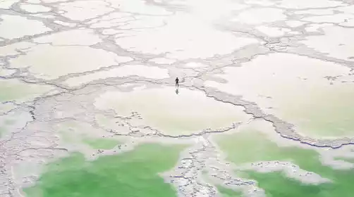
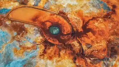
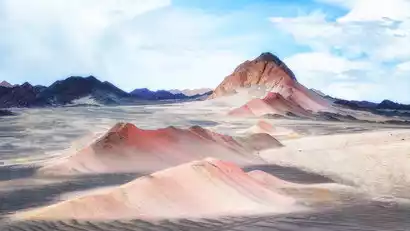
Before entering Huatugou Town, we first took pictures of the Mangya Emerald Lake under the setting sun. After more than ten years of careful "beautification" by potash fertilizer workers, the color of the Mangya Emerald Lake is pure and translucent, like a piece of unpolished jade inlaid in the Gobi Desert, and it has become a new "mirror of the sky".
That night we stayed in Huatugou Town, the seat of Mangya Municipal Government.
Day 5 Huatugou Town → Mangya Emerald Lake → Aiken Spring → Thousand Buddha Cliff → Huatugou Town
·morning
In the morning, we went to Mangya Emerald Lake again to shoot. The sun shone through the thin clouds, reflecting various colors and making the lake look colorful. After the shooting, we continued our journey.
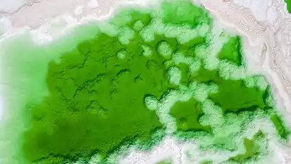
Deep within the Aral Grassland lies the Aiken Spring, a geothermal spring that has been bubbling for millennia. We'll approach the spring and, from the observation deck, gaze down upon it. Its shape resembles a medical cross-section of an eye, its veins clear and lifelike, dotted with numerous turquoise springs. For aerial photographers, it resembles a phoenix spreading its wings in soaring flight.
·afternoon
In the afternoon, go to photograph the sunset scene of [Thousand Buddha Cliff]. When you come here, you will be amazed by the power of nature. The lifelike "clay Buddhas" are forged by wind, rain and time.
After the tourists have finished taking photos, we will drive back to Huatugou Town to check in.
6. Tianhuatugou Town → Mars Highway 1 → Mars Camp → Eboliang Ghost City
·morning
After a free breakfast, we will set off and take photos of the unique uninhabited landforms along the way. If you are lucky, you may also take photos of wild animals.
The rear-wheel drive car drove from G315 onto Mars Highway 1. This highway is called Qaidam Yadan Avenue. There are endless Yadan landforms on both sides. Our vehicle felt like it was driving on the surface of Mars.
·afternoon
We then landed at the [Mars Camp]. The desolate and rugged scenery around the camp made us feel as if we were on Mars.
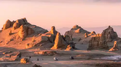
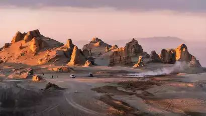
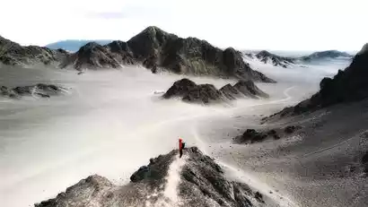
We then drove to the core area of Eboliang Ghost City. If nature were a master craftsman, the fierce northwest wind would be his nimble chisel, and the clusters of hillocks before us would be the unfinished work. From a distance, they resemble the surface of an alien planet; up close, their shapes are diverse. From a bird's-eye view, the hillocks, rigidly parallel due to wind erosion, resemble fleets sailing across the desert.
This year we will also build the China-TravelNote outdoor aesthetic private camp in the heart of Eboliang, equipped with outdoor aesthetic tents, tables and chairs, red wine, etc., breaking the traditional shooting mode, and everyone can immerse themselves in the vast Gobi Desert and take pictures freely and to their heart's content.
·night
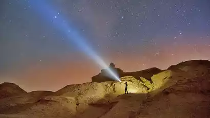
At night, under the guidance of our photography team leader, we created starry skies and star trails at Eboliang Devil City. Through astronomical observation and research, the cloudless night, lack of light pollution, and high air transparency, combined with the ever-changing and bizarre shapes of the Yadan landforms, have made this a mecca for starry sky photography. This time, we'll let China-TravelNote starry sky photography enthusiasts capture their fill!
That night we stayed in tents at the Eboliang Camp.
Day 7: Eboliang Ghost City → Lenghu Town → Heidu Mountain/Yanzhi Mountain → Lenghu Town
·morning
Get up early to capture the sunrise at Eboliang Devil City. In the morning light, this desolate place, carved by time, captivates photographers with its unique charm.
·afternoon
Leaving Eboliang, we passed through Lenghu Town and then arrived at Heidu Mountain for sightseeing and photography. This is a secret photography spot that has only become popular in the past two years. The continuous Yadan surrounded by the Black Mountain Gobi, rendering the beautiful scenery like ink and color painting in the vast sea of sand.
Deep within Heidu Mountain lies an even more unique site: Yanzhi Mountain. Located right next to Heidu Mountain, Yanzhi Mountain is tinged with red, resembling a touch of crimson in a natural ink painting. It's a great place to take photos, and we'll drive there to capture it.
Suitable for departure and return to Lenghu Town for check-in.
Day 8 Lenghu Town → Dunhuang★ Disbandment Day
All day
After a free breakfast, we departed, stopping briefly for photos at the ruins of the Lenghu Oil Base. Once fueled by oil production, the town is now abandoned due to resource depletion, exuding a unique, desolate beauty. Walking among the ruins, glancing at the abandoned artifacts and the powerful yet variegated slogans on the walls, it felt as if I were witnessing the bustling oil production scene of yesteryear.
Continue onward, arriving in Dunhuang in due time. You'll be transferred to the train station and then to Dunhuang Airport. If you're not in a hurry to return, you can arrange your own Dunhuang tour. Visit the Mogao Grottoes, Mingsha Mountain and Crescent Lake, the Dunhuang Museum, the Old City of Dunhuang, Yangguan Pass, and the Western Thousand Buddha Caves, among other attractions. Please make reservations in advance if you wish to visit the Mogao Grottoes.