Day 1 Guangzhou → Meishajian → Guangzhou
07:30
Meet and sign in at Kecun Exit B (Line 3 & Line 8)
08:00
After everyone is gathered, we set off. The tour leader introduces the tourists to each other and explains the itinerary, singing and laughing all the way to the destination.
10:30
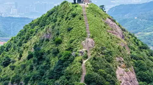
Arrive at the hiking starting point (approximately 380 meters above sea level). After warming up, trek through the stairs and jungle to the Meisha Peak Observation Deck, where you can enjoy a 360° panoramic view!
The scenery at Meishajian is beyond your imagination! After climbing the stone steps that resemble a "road to heaven" and reaching an altitude of 753 meters, the scenery before you will surely shock you deeply.
13:00
Rest and eat at the summit (please bring your own snacks!) The 360-degree viewing platform offers panoramic views of Dapeng Bay to the southeast, Wutong Mountain, Shenzhen's highest peak, to the southwest, and panoramic views of OCT East to the east and north. You can also take in views of Yantian Port, Dameisha, Xiaomeisha, and even the Sanzhoutian Reservoir. On clear days, you can also witness the mist-shrouded "Ladder to the Clouds" and a stunning sunset.
2:00 PM
After a brief rest and taking photos, we continued our afternoon hike down the mountain road.
3:30 PM
Arriving at the internet-famous Yunhai Square, a pure white three-story building that resembles a spaceship, it got its name because the square is located at a high altitude and often has the wonders of the sea of clouds.
4:00 PM
After visiting Yunhai Square, go down the mountain. The main way down is steps.
5:30 PM
Return to the end of the hike, hike appropriately, and return to Guangzhou after everyone is together.
8:30 PM
Back at the Kecun subway station, we kissed goodbye with tears in our eyes. Remember to report home safely and make plans to travel next week.


