Day 1: Gathering at various locations - Mangshi
All day
On the full-day meeting day, you'll have free time to travel to the meeting hotel (check in by submitting "China-Travel Note + Name").
Mangshi, a small frontier city in southwestern Yunnan, is the only city in China named with a single character. "Menghuan" in the Dai language means "City of Dawn." It's the capital of Dehong Dai and Jingpo Autonomous Prefecture in Yunnan Province. It embodies the ethnic charm of a frontier treasure, while also imbued with the exotic charm of Southeast Asia due to its border location.
Winter temperatures in Mangshi range from 13-24°C, offering a refreshingly warm welcome, making it a perfect place to stop and stroll. Early arrivals can explore Xinwanchang, Mengbanasi, Bingwu Street, and the Dai Ancient Town, or explore the unique Dai cuisine of western Yunnan, slowing down your journey.
Recommended free activities:
Mangshi Citywalk
Mangshi is filled with exotic charm, with Dai-style yellow glazed tile buildings, tropical palm trees lining the streets, temples and pagodas everywhere, and people slowly passing by on motorcycles, making you feel like you've been transported to Southeast Asia. Starting from Munao Zongge Road, crossing Tuanjie Street, entering the Best Food City to try local snacks, and then passing through Bodhi Street to the Bodhi Temple, you can immerse yourself in the slow pace of life of the locals.
Sunset at the Menghuan Shwedagon Pagoda
The Great Golden Pagoda and the Silver Pagoda, located atop Leiyarang Mountain at an altitude of 1,079 meters in southeast Mangshi, are iconic landmarks of Mangshi and sacred to the Dai people. The Menghuan Great Golden Pagoda is Asia's largest hollow Buddhist pagoda, guarded by 16 deities, including an elephant, a golden rooster, a bird of wisdom, and the twelve zodiac animals. These are said to represent the 16 animals that successfully reincarnated into the Buddha's life. From the Menghuan Great Golden Pagoda, you can overlook downtown Mangshi. After visiting the Great Golden Pagoda, wait for sunset and the lights to come on, revealing a whole new charm.
[How to get to Mangshi]
1️⃣ Plane: There are direct flights from Shanghai, Beijing, Guangzhou, Hangzhou, Shenzhen, Nanjing, etc., and you can also transfer in Kunming
. 2️⃣ High-speed rail: There is no direct high-speed rail to Mangshi. You can take the high-speed rail from Kunming to Baoshan, and then take a bus from Baoshan Passenger Transport Terminal to Mangshi.


Day 2 Mangshi → Yingjiang
All day
Hiking Information
Hiking route: about 6 km, with an altitude climb of 168 meters and a descent of 180 meters (starting point 862 meters - Alsophila spinulosa forest 883 meters - ridgeline 1030 meters - bird pond 968 meters - end point 850 meters), taking about 4 hours
Meals: Breakfast and lunch are included. Lunch is provided on the way and is provided at the starting point. Please bring your own food to prepare for any food problems and to replenish your energy during the hike.
Luggage information: Pack your luggage in advance, leave large luggage on the tour bus or in the inn, and carry necessary items on foot to travel light.
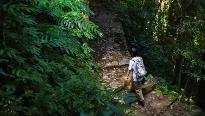
Explore the western branch of Gaoligong and the wonders of the Irrawaddy River rainforest
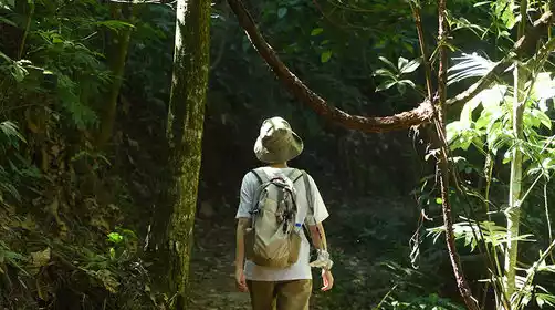
The Gaoligong Mountains split into two in the north of Tengchong. The western branch runs along the Lianghe and Yingjiang Rivers into the Indochina Peninsula. Yingjiang, heavily influenced by the southwest monsoon, offers favorable water and heat conditions, nurturing tropical rainforests in its valleys and home to numerous iconic tropical species, particularly hornbills. Departing from Mangshi, we'll head directly to Yingjiang Hornbill Valley to explore the wonders of this tropical rainforest.
丨Tropical rainforest hiking experience the wonders of the rainforest
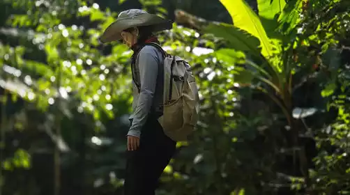
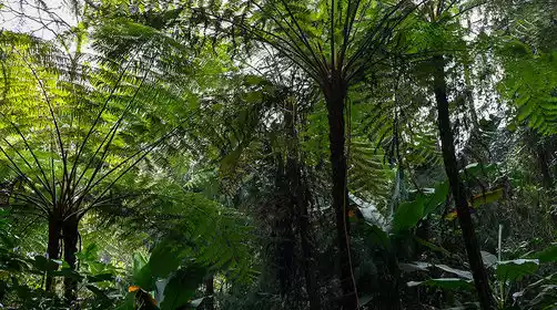
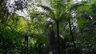
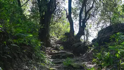
After arriving at Hornbill Valley, we'll begin our rainforest hike, weaving through the dense, sun-blocking forest. We'll discover distinct layers of trees, shrubs, and herbs, with epiphytes like bird's nest ferns everywhere. As we ascend and descend the valley, we'll encounter towering nanmu trees, wild banana trees, also known as spinulosa, and vast expanses of Amomum villosum. With our guide, we'll discover new tropical plants and colorful insects, identify species by listening to their calls, and truly experience the wonders of the rainforest. We'll also learn ancient survival techniques from the locals, identify edible plants, and gather wild vegetables and fruits.
Birdwatching to experience the charm of species gene pools
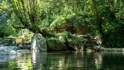
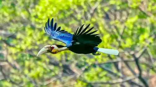
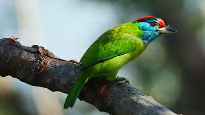
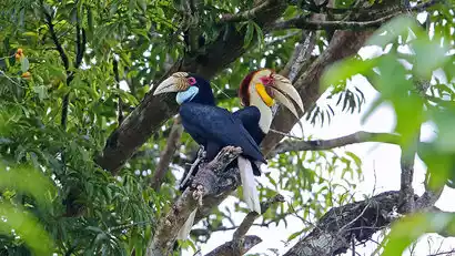
Home to over 500 bird species, Hornbill Valley is the only place in China where you can consistently observe three species of hornbills simultaneously: the Double-horned Hornbill, the Crested Hornbill, and the Crested Hornbill. Other fascinating birds include the Grey Peacock Pheasant, the Blue-green Magpie, and the Silver Pheasant. During the hike, we'll follow our guide into a bird pond, where we'll quietly watch for small birds to emerge and identify and learn about them. (This pond is primarily for observing small birds.)
Special note: Bird watching is greatly affected by natural factors such as weather and temperature. Please understand that the birds observed may vary.
丨Observe nocturnal species amidst the chirping of insects and frogs
After sunset, we will enter the dark forest to search for nocturnal animals. We will have the opportunity to encounter animals we have never seen before, such as civets, slow lorises, owls, flying squirrels, etc. After the first rainfall, we will also have the opportunity to observe amphibian species such as forest frogs and tree frogs, and experience the unique vitality of nature in the dark.
Day 3 Yingjiang → Tengchong
All day
Enter the bird pond again and wait for the star bird species, the hornbill
From February to June each year, hornbills return to Hornbill Valley to nest and breed. We chose a hornbill pond and followed our guide to observe it. Patience is required, as we wait for the hornbills to return from searching for food or materials to build their nests. Their large size makes them incredibly graceful in flight. Depending on the time of year, we might spot male and female birds together, males feeding nesting females, or chicks emerging from their troughs.
Special note: The stable observation period for hornbills is from February to June each year. Batches outside this period will be replaced by Tengchong Rehai Scenic Area. Bird watching is greatly affected by natural factors such as weather and temperature, so hornbills may not be observed. Please understand.
Western Yunnan Anti-Japanese War Memorial Hall, pay tribute to the martyrs of the Anti-Japanese War
Leaving Hornbill Valley in good time, we headed to Tengchong. Our first stop was the Western Yunnan Anti-Japanese War Memorial Hall. This cemetery, built to commemorate the fallen soldiers of the 20th Group Army of the Chinese Expeditionary Force during the capture of Tengchong during the War of Resistance Against Japanese Aggression, is one of the largest and best-preserved memorials for those killed on the front lines of the War of Resistance Against Japanese Aggression in China. The Chinese Expeditionary Force engaged in fierce battles with the Japanese invaders in Western Yunnan, blocking the enemy on the west bank of the Nujiang River. The intensity of the battle, known as the "Scorched Earth War of Resistance," commemorates a tragic and heroic chapter in history. Here, we offer a white chrysanthemum to honor those who sacrificed their lives for peace and to restore national memory.
Heshun Ancient Town Citywalk, explore the important town on the Ancient Tea Horse Road
Heshun Ancient Town is a key town on the Ancient Tea-Horse Road and a must-stop on the Southwest Silk Road. Built around a mountain, the town's buildings rise gradually from east to west, stretching for two to three kilometers. The town is surrounded by a vast plain, with a clear stream winding around the village and willows gracing the banks, creating a harmonious, pastoral landscape. We'll enter Heshun Ancient Town and explore its winding alleys, visiting its old houses, streets, and ancient ancestral halls. At this time, the ancient town remains peaceful, yet the crowds remain. Unlock Heshun with 5,000 steps.

Day 4 Tengchong → Gaoligong Mountain → Wuhe Township
All day
Hiking Information
Hiking route: The whole journey is about 12 km, with an altitude climb of 313 meters and a descent of 504 meters (entry point 2137 meters - wind pass 2450 meters - exit point 1946 meters), and it takes about 6 hours
Meals: There will be no supplies along the way, so you need to bring your own lunch and drinking water. Dinner will be served in the village after you leave the mountain.
Luggage information: Pack your luggage in advance, place large luggage on the tour vehicle, and carry necessary items on foot to travel light.
Retracing the Stilwell Road and hiking the Southern Silk Road
After breakfast, we will go up the mountain along the Laobaoteng Highway and enter Gaoligong Mountain. This highway, which was opened to traffic in 1952, was built along the original Salt Horse Road. It was originally planned to be the main line of the Sino-Indian Highway (also known as the Stilwell Road). Due to various factors, it was not completed during the Second World War. It is of great historical significance.
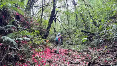
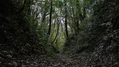
After a brief rest at Gaoligong Mountain, we'll follow local forest rangers into the mountain's pristine forests, following an ancient trail to search for traces of the caravans' passage. While the caravans have faded into obscurity, the remains of beacon towers and watchtowers, the smooth stone paths, and the deep hoofprints of horses still remain, all testament to the prosperity of this millennia-old Southern Silk Road. For centuries, with no caravans passing through, the forest has grown to a point where it obscures the sun, moss covers the trees and various remains, and the ancient trail is now covered in fallen leaves. Feel the lingering traces of history as tall trees grow freely along the trail, allowing visitors to explore the biodiversity of Gaoligong Mountain.
Special note: Gaoligong Mountain hiking is greatly affected by policies. The hiking route will be flexibly adjusted according to the current mountain entry policy. The Silk Road may be replaced by hiking in other areas of Gaoligong Mountain. The fee remains unchanged. Please understand.
Day 5 Wuhe Township → Gaoligong Mountain Natural Park → Lujiang Town
All day
Hiking Information
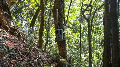
Hiking route: The entire route is approximately 8 kilometers, with an altitude gain of 110 meters and a descent of 133 meters (Gaoligong Mountain Nature Park entrance 2138 meters - Huipo 2248 meters - Jiujinliangpo 2297 meters - mountain exit 2115 meters). It takes about 4 hours. The placement of the infrared monitoring camera will result in different hiking altitudes and distances.
Meals: There will be no supplies along the way, so you need to bring your own lunch and drinking water. Dinner will be ordered upon arrival in Lujiang Town.
Luggage information: Pack your luggage in advance, place large luggage on the tour vehicle, and carry necessary items on foot to travel light.
Wander in Gaoligong Mountain Nature Park and be a forest ranger for a day
Today, we'll return to Gaoligong Mountain and visit Gaoligong Mountain Nature Park. Guided by a ranger, we'll wander the park along an ecological monitoring route, identifying protected species like the long-stamen magnolia and the red-flowered magnolia, as well as wild fruits favored by animals. We'll listen to wildlife calls and observe their tracks and feces to identify their species. We'll search for amphibians in the Black Water Pond and visit invasive plant monitoring plots. If you're lucky, you might even hear the song of the Gaoligong Mountain's star species, the Skywalker Gibbon, and encounter plant species unique to the mountain. We'll also experience other aspects of a ranger's work.
丨Gaoligong Mountain Ecological Classroom
Before the hike begins, we enter the Gaoligong Mountain Nature School, where we specially invite staff from the Gaoligong Mountain National Nature Reserve to present a Gaoligong ecological classroom, showcasing the reserve's natural ecological monitoring results. We listen to the difficulties and interesting stories they encounter in their ecological protection work, learn more about the work of ecological protection, and experience firsthand the difficulty of ecological protection.
Tasting honey from a beehive at a forest ranger's home
The widespread adoption of Italian honey bees in domestic beekeeping has significantly squeezed out the ecological niche of native Asian honey bees. Remarkably, the bees cultivated in Gaoligong Mountain are still native Asian honey bees. We will follow the rangers to where they set up their hives, observe the bees at work, harvest a small piece of honey on site, and taste the sweetness brought by the flowers of Gaoligong Mountain.
Recovering and placing infrared surveillance cameras
Bring your infrared monitoring camera with you to wildlife monitoring sites, learn how rangers find monitoring points, and learn how to place and retrieve infrared monitoring cameras. The retrieved infrared cameras may capture species such as porcupines, red pandas, and leopard cats, or they may capture nothing. This is something rangers often encounter, so treat it with a normal mind.
Visit a coffee farm and experience handmade coffee
In the afternoon, we will return to Lujiangba. The unique subtropical dry-hot valley climate has made Lujiangba one of the important coffee planting bases in my country. The famous Baoshan small-grain coffee is produced here. In recent years, the popularity of Yunnan boutique coffee has continued to rise, and many coffee estates with unique styles have been bred here. We will enter the estate and learn the [traditional coffee roasting method]. We will experience the entire process of charcoal roasting-grinding-brewing-tasting, and further expand our coffee knowledge here.
Day 6 Lujiang Town → Baihualing → Baoshan ★ Disbandment Day
All day
Hiking Information
Hiking route: about 6km, with an altitude gain of 178m and a descent of 178m (starting point 1614m - stone steps 1637m - banana forest 1551m - Zaotang River 1459m - wild hot spring 1500m - end point 1614m), taking about 3 hours;
Meal Information: It is recommended to bring some snacks to replenish energy during the hike. You can order a meal for lunch after returning to Baihualing Village.
Luggage information: Pack your luggage in advance, place large luggage on the tour vehicle, and carry necessary items on foot to travel light.
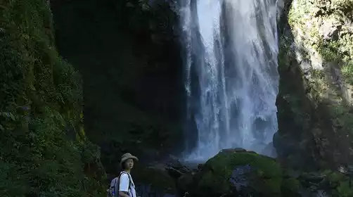
Farewell to Gaoligong at Baihualing, encountering large waterfalls and wild hot springs
After breakfast, depart Baihualing and re-enter the eastern foothills of Gaoligong Mountain. Following streams, we'll pass through dense primeval forests, encountering subtropical plants like Monstera and Musa acuminata. This provides a unique perspective on nature, allowing us to experience the diversity and wonder of the world. Deep within Gaoligong Mountain lies a natural hot spring, where steaming water rises from the ground, gathering into a clear spring. Bring a change of clothes and feel the warmth of Mother Earth.
Today is the disbanding day, and we will go to Baoshan to pick up the passengers at the station/airport around 13:30. It takes about 2 hours from Baihualing to Baoshan Station and about 2.5 hours to Baoshan Yunrui Airport. For the return train, please book a train after 16:30, and for the flight, please book a flight after 18:00. Please relax the schedule during holidays.