
Day 1 Shangri-La City → → Yading Village
All day
Hiking Information
No hiking today
【Itinerary Information】
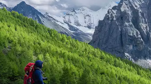
This morning we will gather at the meeting point in Shangri-La City at around 9:00 this morning and then depart for Daocheng Yading. We will usually arrive at the entrance of the Yading scenic area at around 3:00 or 4:00 in the afternoon and then transfer to a vehicle to enter Yading Village.
We stayed in Aden Village that night. After dinner, the team leader held a pre-trip meeting to check personal equipment.
Day 2 Yading Village → Chonggu Temple → Bayu Camp → Poyongcuo
All day
Hiking Information
Hiking route: about 7 km, with a cumulative altitude increase of about 922 meters and a descent of about 137 meters (Zhaguanbeng 3900 meters - Bayu Camp 4520 meters - Boyong Co 4750 meters), about 6 hours
Luggage Information: Luggage should be packed in advance. Large luggage should be left at the Yading Village Hotel. Non-essential items for camping and hiking should be packed in backpacks and delivered to the camp by the horse team (limit 15kg per person). You should carry necessary items such as supplies, warm and windproof clothing, raincoats, cameras, etc. during the hike in a backpack.
Meals: Meals are included throughout the day. Lunch is served on the trail, and dinner is served at the camp. Meals are provided at the starting point and must be brought by the hiker. It is recommended that you bring your own supplies in case of emergency.
【Itinerary Information】
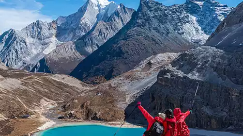
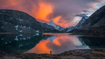
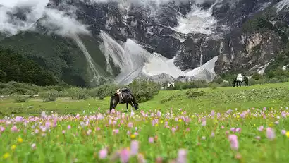
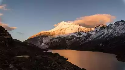
Today's destination is Boyongcuo. Hidden among the snow-capped mountains, Boyongcuo resembles a shimmering pearl, a crystalline fairy tear, fallen to earth. Its colors change slightly with the seasons, and from here you can see the three sacred mountains of Yading all in one frame. Again, take the scenic shuttle bus to Zhaguanbeng and then begin your hike. Once you reach Boyongcuo, you can circle the lake and find your favorite spot to capture the reflection of the sun. On a clear day, you'll be able to see the three sacred mountains in full view, with Boyongcuo shimmering in all its glory.
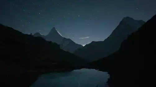
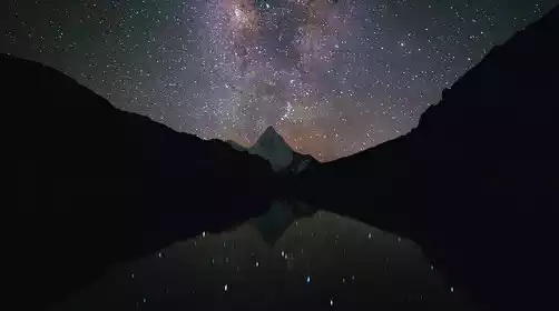
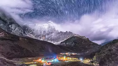
That night, we camped by Boyongcuo Lake. After enjoying afternoon tea and dinner facing the snow-capped mountains, we waited for the sunset behind them. If there were no clouds at night, we could see a starry sky, interweaving with the nearby lake and the distant snow-capped mountains, creating a dreamlike scene.
Day 3: Tianboyongcuo → Cuogaida Pass → Cuogaida Lake → Niangcuo Viewpoint → Garuo Ranch → Gongga Zhaze
All day
Hiking Information
Hiking route: about 14 km, with a cumulative elevation gain of about 674 meters and a descent of about 1,318 meters (Boyong Co 4,750 meters - Cuogaida Pass 4,890 meters - Cuogaida Pass 5,036 meters / Qiesagading Pass 4,912 meters - Galuo Niuchang 4,450 meters - Gongga Zhaze 4,097 meters), about 7 hours
Luggage Information: Non-essential items for camping and hiking should be packed in a pack and delivered to the next camp by the horse team (limit 15kg per person). Use a mountaineering bag to carry the necessary items for the hike, such as supplies, warm and windproof clothing, raincoat, camera, etc.
Meals: Meals are included throughout the day. Lunch is served on the trail, and dinner is served at the camp. Meals are provided at the starting point and must be brought by the hiker. It is recommended that you bring your own supplies in case of emergency.
【Itinerary Information】
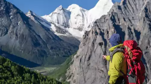
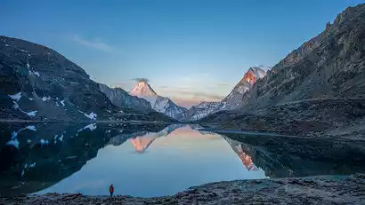
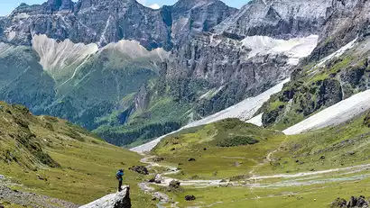
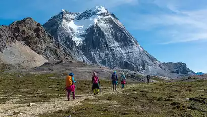
If the weather is good, Boyongcuo is a great spot to photograph the reflection of Xiannairi Mountain in the sun. Before sunrise, pitch your tent and wait for the sun to shine upon the mountain. The snow-capped peaks, stained red, are reflected on the lake, a breathtaking sight that leaves you speechless. After enjoying breakfast at the campsite, depart. It takes about two hours to cross the Cuogaida Pass, pass the Cuogaida Lakes, and reach the Niangcuo Viewpoint. After crossing the slope, you'll rejoin the Luya Trail and follow the gentle mountain road for over an hour to reach the Garuo Ranch. (If the weather is bad, cross the Qisagading Pass to reach the Garuo Ranch.) Continue past the Chagong Ranch, descend along the river valley, cross primeval forest, and ascend the Baishui River upstream to reach Gongga Zhaze Camp, the lowest point of the entire route and closest to Xianuoduoji.
Day 4: Gongga Zhaze → Xianuoduoji Horizontal Pass → Zabala Camp
All day
Hiking Information
Hiking route: about 7 km, with a cumulative altitude climb of about 736 meters and a descent of about 443 meters (Gongga Zhaze 4097 meters - Xianuoduoji horizontal pass 4524 meters - Xianuoduoji south slope flowing stone beach 4574 meters - Zabala camp 4378 meters), about 6 hours
Luggage Information: Non-essential items for camping and hiking should be packed in a pack and delivered to the next camp by the horse team (limit 15kg per person). Use a mountaineering bag to carry the necessary items for the hike, such as supplies, warm and windproof clothing, raincoat, camera, etc.
Meals: Meals are included throughout the day. Lunch is served on the trail, and dinner is served at the camp. Meals are provided at the starting point and must be brought by the hiker. It is recommended that you bring your own supplies in case of emergency.
【Itinerary Information】
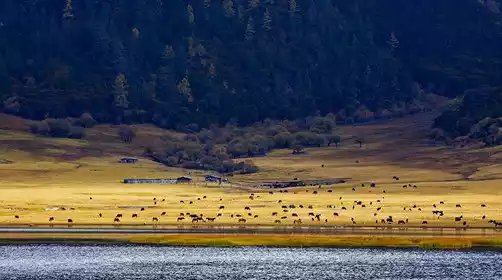
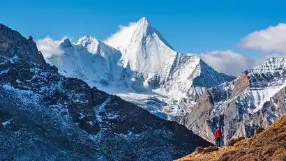
Gongga Zha, located directly east of Shannuo Doji, offers a prime vantage point for viewing the golden mountain in the sun. Few outdoor enthusiasts venture here, but on clear days, you can pitch your tent and photograph the mountain from the campsite. Departing after breakfast, we'll ascend several small passes, turning from the eastern slope of Shannuo Doji to the southern slope to reach the Shannuo Doji Cross Pass. After crossing the pass, we'll traverse the mountainside, admiring the mountain's lesser-known splendor. We'll overlook several large cattle pastures, dotted with wildflowers and azaleas in summer and picturesquely colored forests in autumn. Finally, we'll reach camp below Zabala Pass. This is a relatively relaxing day of the trip, allowing for plenty of rest and refreshment.
Day 5 Zabala Camp → Zabala Pass → Niangxi Ranch → Yangmaiyong Horizontal Pass → Xinguo Ranch
All day
Hiking Information
Hiking route: about 10 km, with a cumulative altitude increase of about 874 meters and a descent of about 989 meters (Zabala Camp 4378 meters - Zabala Pass 4750 meters - Niangxi Cattle Farm 4400 meters - Yangmaiyong Crossroad Pass 4440 meters - Xinguo Cattle Farm 4300 meters), about 7 hours
Luggage Information: Non-essential items for camping and hiking should be packed in a pack and delivered to the next camp by the horse team (limit 15kg per person). Use a mountaineering bag to carry the necessary items for the hike, such as supplies, warm and windproof clothing, raincoat, camera, etc.
Meals: Meals are included throughout the day. Lunch is served on the trail, and dinner is served at the camp. Meals are provided at the starting point and must be brought by the hiker. It is recommended that you bring your own supplies in case of emergency.
【Itinerary Information】
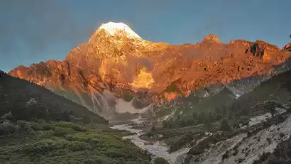
Departing in the morning, we made a concerted effort to cross the Zabala Pass at an altitude of 4,750 meters. The climb, over 300 meters, was steep and took 1-2 hours. After crossing Zabala Pass, we passed through Xianuoduoji's territory and reached the southern slope of the Maiyong Mountain. The gentle descent continued, passing Niangxi Cattle Farm, the Manjusri Bodhisattva enshrinement site, several landslide zones, and the relatively easy Yangmaiyong lateral pass. We arrived at our campsite, Xinguo Cattle Farm. Along the way, we enjoyed breathtaking views of the snow-capped mountains and canyon. Xinguo Cattle Farm, located at the foot of the southwestern slope of Yangmaiyong, is a spacious campsite. In the evening, we had the opportunity to admire the golden sunset over Yangmaiyong Mountain.
Day 6: Xinguo Cattle Farm → Black Lake Pass → Butterfly Rock → Snake Lake Pass → Snake Lake Camp
All day
Hiking Information
Hiking route: about 12 km, with a cumulative elevation gain of about 975 meters and a descent of about 798 meters (Xinguo Niuchang 4300 meters - Black Lake Pass 4750 meters - Butterfly Stone 4580 meters - Snake Lake Pass 4730 meters - Snake Lake Camp 4500 meters), about 8 hours
Luggage Information: Non-essential items for camping and hiking should be packed in a pack and delivered to the next camp by the horse team (limit 15kg per person). Use a mountaineering bag to carry the necessary items for the hike, such as supplies, warm and windproof clothing, raincoat, camera, etc.
Meals: Meals are included throughout the day. Lunch is served on the trail, and dinner is served at the camp. Meals are provided at the starting point and must be brought by the hiker. It is recommended that you bring your own supplies in case of emergency.
【Itinerary Information】
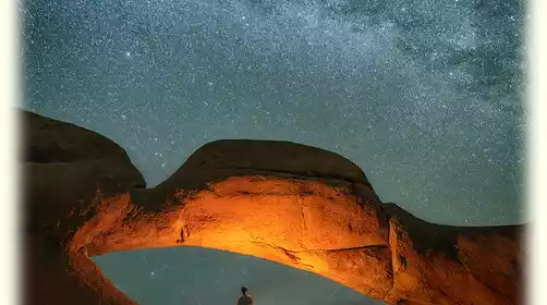
Those interested can rise early today to watch the sun illuminate the sacred Yangmaiyong Mountain's ridge. After setting off, we'll ascend several small passes and landslides. From the mountainside, we'll have distant views of Yangmaiyong and Xianuoduoji. At noon, we'll reach the Black Lake Pass, the turning point for Yangmaiyong, offering a panoramic view of the Black Lake. Following this, a gentle stone path leads to Jiadu Niuchang, where you'll find Butterfly Rock, also known as Locke Stone, where Dr. Locke once photographed the lake. Further on, we'll reach Jiaducuo, where the calm waters offer excellent reflection photography. Continuing on, we'll reach Snake Lake Pass at 4,750 meters, offering a panoramic view of the emerald green ribbon of Snake Lake, the backside of Xiannairi, and the western side of Yangmaiyong, a dream photography spot. We'll then descend 200 meters to camp by Snake Lake, where we can capture the reflection of Yangmai and the starry sky.
Day 7 Snake Lake Camp → Songduo Pass → Five-Color Lake → Milk Lake → Resongcuo → Kasi Cowshed
All day
Hiking Information
Hiking route: about 13 km, with a cumulative elevation gain of about 558 meters and a descent of about 698 meters (Snake Lake Camp 4500 meters - Songduo Pass 4670 meters - One Mirror Twin Lakes shooting point 4700 meters - Resongcuo 4521 meters - Kasi Cowshed Camp 4430 meters), about 7 hours
Luggage Information: Non-essential items for camping and hiking should be packed in a pack and delivered to the next camp by the horse team (limit 15kg per person). Use a mountaineering bag to carry the necessary items for the hike, such as supplies, warm and windproof clothing, raincoat, camera, etc.
Meals: Meals are included throughout the day. Lunch is served on the trail, and dinner is served at the camp. Meals are provided at the starting point and must be brought by the hiker. It is recommended that you bring your own supplies in case of emergency.
【Itinerary Information】
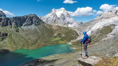
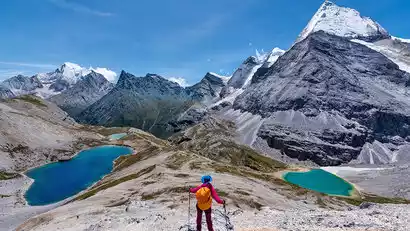
Departing in the morning, we crossed the Songduo Pass and climbed to the Shuanghu check-in point for photos, including aerial views of the Milk Lake and the Five-Colored Lake. These lakes are surrounded by the Xiannairi and Yangmaiyong lakes. The Milk Lake gets its name from its white outer ring, which transitions to emerald green in the center, like a piece of jade embedded in the mountains. The Five-Colored Lake is a sacred lake in Tibet, displaying different colors in different weather and light conditions. We then returned to the Songduo Pass, descending past Resongcuo Lake to camp at the Kasi Cowshed.
Day 8 Kasi Cowshed → Songluo Pass → Pearl Lake → Chonggu Temple → Yading Village
All day
Hiking Information
Hiking route: about 11 km, with a cumulative elevation gain of about 561 meters and a descent of about 1110 meters (Kasi Niuping Camp 4430 meters - Songluo Pass 4650 meters - Pearl Sea 4065 meters - Chonggu Temple 3965 meters - Zhaguanbeng 3900 meters), about 6 hours
Luggage Information: Non-essential items for camping and hiking should be packed in a pack and delivered to the next camp by the horse team (limit 15kg per person). Use a mountaineering bag to carry the necessary items for the hike, such as supplies, warm and windproof clothing, raincoat, camera, etc.
Meals: Meals are included throughout the day. Lunch is served on the trail, and dinner is served at the camp. Meals are provided at the starting point and must be brought by the hiker. It is recommended that you bring your own supplies in case of emergency.
【Itinerary Information】
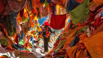
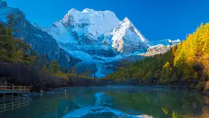
Departing in the morning, we'll traverse the slopes of Mount Xiannairi. To our left lies the famous Kasi Hell Valley. Crossing the Songluo Pass takes approximately 3-4 hours. This is the last pass on this trip. Songluo Pass is the only way from Kasi Hell Valley to the Paradise of Yading, and is therefore heavily decorated with prayer flags. The journey continues downhill, offering stunning views of the sacred Mount Xiannairi. After passing through a forest, we'll walk up a plank path to the Pearl Lake, nestled in the dense forest directly below Xiannairi. Lush and lush in summer, the forests shimmer in vibrant colors in autumn, and the rippling waters of the lake reflect the snow-capped mountains and rice paddies, making it a perfect spot for photographing the scenery of Xiannairi. After a brief stay at the Pearl Lake, we'll descend to Chonggu Temple and take the scenic bus back to the Yading Village Hotel.
Day 9 Aden → Shangri-La City *Disbandment Day
All day
Today is the return day. We will take the scenic shuttle bus from Yading Village at around 9:00 and go to the Daocheng Yading Scenic Area Visitor Center to transfer to the tour vehicle. Then we will return to Shangri-La City. The arrival time will be around 4 or 5 pm. The specific time depends on the road conditions on that day.
Tourists can also choose to leave the group at Shangri-La Town (Riwa) in Daocheng County and return to Daocheng Yading Airport on their own (the drive is about 160 kilometers and takes about 3 hours). We can help arrange a shared car to the airport, but the cost is borne by the tourists themselves.