California Highway 1
What are the most recommended things to do in California Highway 1?
- Drive or ride along the scenic California Highway 1 for breathtaking coastal views.
- Stop at Big Sur, Bixby Creek Bridge, and McWay Falls for photography and sightseeing.
- Explore coastal towns like Monterey, Santa Cruz, and Malibu.
- Hike along trails in state parks such as Julia Pfeiffer Burns and Garrapata State Park.
- Visit beaches, tide pools, and wildlife viewing spots along the route.
- Enjoy local seafood and wine in roadside restaurants and small towns.
Introducing California Highway 1
Located north of Los Angeles and south of San Francisco, this renowned scenic highway winds along the Pacific Ocean to San Francisco. As it's not a major thoroughfare, it enjoys low traffic and stunning scenery. Along the way, numerous raised dirt roads are thoughtfully designed for drivers to stop and enjoy the scenery. California Highway 1 connects San Francisco and Los Angeles from north to south, winding along the west coast of the United States for over 1,000 kilometers. National Geographic magazine named it one of the 50 must-see places in a lifetime.
Climate and best time to travel
Mediterranean climate;
Suitable for all seasons
Recommended number of days and locations for visiting
Hearst Castle
Heading south on Highway 1, you'll find the renowned Hearst Castle, the official residence of American media mogul William Randolph Hearst. This Spanish-style mansion is the only castle in the United States and the second-largest private residence in the country. It's said to have once been the world's most expensive private residence and the largest private zoo. The often fog-shrouded West Coast gives the castle a fairy-tale-like feel, imposing and magnificent.
Santa Barbara
After leaving the fort, we spent the night in Santa Barbara, a beautiful, tranquil coastal town renowned for its idyllic climate, Spanish-style architecture, and breathtaking mountains, valleys, and beaches. The city's architecture is remarkably Mediterranean. The vibrant colors are refreshing, with white walls and red tiles adorning the lush greenery. The seaside is bathed in azure waters and white waves, creating an elegant and charming cityscape shrouded in a veil of European romance.
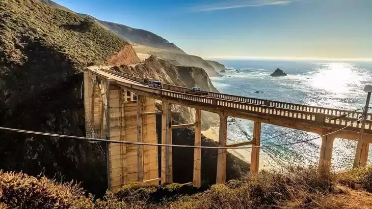
Western scenery
Many sections of U.S. Highway 1 are built on cliffs, bordering the Pacific Ocean. Construction sites are common along the way, forcing traffic in both directions to separate and travel together. Many American open-top SUVs whiz by. The route is remarkably pristine, with no overdeveloped coastal roads or high-rise, screen-like resort hotels. The Western spirit of conquering nature is ultimately based on a harmonious coexistence with it. This is California, this is the American West.
Tickets
free
Attraction opening hours
All day
Most Popular FAQs for California Highway 1
What is the history and significance of this attraction/city?
California Highway 1, also known as the Pacific Coast Highway, is an iconic coastal road stretching along the California coastline. Built in the 1930s, it connects major cities and scenic landmarks, offering stunning ocean views and access to California’s natural and cultural heritage.
Where is it located and how do I get there (metro, bus, taxi, walking)?
- Location: Runs along the California coastline from Dana Point in Southern California to Leggett in Northern California.
- Access by car or rental vehicle is the most practical for exploring the highway.
- Public transportation is limited; some segments accessible via local buses or tours.
- Walking and cycling are possible in short stretches within towns or state parks.
What are the opening hours and best times to visit?
- Open year-round, though some sections may close due to landslides or road work.
- Best times: Spring to early fall for mild weather and clear coastal views.
- Early mornings or weekdays are less crowded.
What is the entrance fee/ticket price, and how to buy tickets (online/offline)?
There is no fee to drive on California Highway 1 itself. State parks or attractions along the highway may have entrance fees, payable at park entrances or online in advance.
Do I need to book tickets in advance, and how far in advance?
Advance booking is recommended for popular state parks, campgrounds, or attractions along the route, usually 1–3 months ahead during peak season.
How much time is needed to fully explore it?
A complete drive along the entire highway can take several days. For a scenic segment (e.g., Big Sur), 1–2 days is sufficient to explore key viewpoints and attractions.
What are the must-see highlights or main areas inside?
- Bixby Creek Bridge and Big Sur coastline.
- McWay Falls in Julia Pfeiffer Burns State Park.
- Carmel-by-the-Sea and Monterey Bay.
- Santa Cruz beaches and boardwalk.
- Malibu beaches and cliffs.
- Point Lobos State Natural Reserve.
Are guided tours or audio guides available (and in which languages)?
Guided tours are available in English, including bus tours and private driving tours. Audio guides may be included in some apps or tours, primarily in English.
What are the best viewpoints or photography spots?
- Bixby Creek Bridge for iconic coastal bridge shots.
- McWay Falls for waterfall and ocean photography.
- Point Lobos State Reserve for wildlife and ocean views.
- Various pullouts along Big Sur for panoramic views of cliffs and beaches.
- Sunset views near Malibu and Santa Monica.
What is the recommended route or itinerary inside?
- Southern California start: Dana Point → Malibu → Santa Monica → Santa Barbara.
- Central Coast: San Luis Obispo → Big Sur → Monterey → Carmel.
- Northern California: Santa Cruz → Half Moon Bay → San Francisco → Leggett.
- Plan stops at key parks, beaches, and scenic pullouts.
Are night visits, light shows, or special tours available?
Highway 1 is primarily a daytime scenic drive. Night driving is possible but less scenic; special tours such as sunset or guided coastal tours may be available in towns along the route.
Is it crowded, and when are the least crowded times/days to visit?
- Peak season (summer months) can be busy, especially in Big Sur and popular towns.
- Least crowded: weekdays, early mornings, or shoulder seasons (spring/fall).
What facilities are available (toilets, food, water, rest areas, shops)?
- Restrooms and visitor centers at state parks.
- Restaurants, cafes, and roadside diners in towns along the highway.
- Picnic areas, water fountains, and small shops at scenic pullouts.
Is the attraction accessible for elderly, children, or disabled visitors?
- Driving segments are accessible to all.
- Some trails and viewpoints may have steep or uneven terrain, limiting wheelchair access.
- Children are safe in vehicles; outdoor trails vary in difficulty.
Is cash needed or are cards/mobile payments accepted?
- Most restaurants, gas stations, and attractions accept cards and mobile payments.
- Carry some cash for remote areas or small vendors.
What restaurants or cafes are available inside or nearby?
- Seafood restaurants and local diners in Monterey, Carmel, Santa Cruz, and Malibu.
- Cafes and roadside snack shops along scenic stops.
- Upscale dining options in coastal towns.
Are there vegetarian/vegan/halal food options?
Vegetarian and vegan options are widely available in urban towns along the route. Halal options are limited but available in larger cities like San Francisco and Los Angeles.
What hotels or accommodations are close to the site?
- Hotels, motels, and inns in towns such as Carmel, Monterey, Santa Cruz, and Malibu.
- Camping options in state parks like Julia Pfeiffer Burns and Point Lobos.
- Luxury resorts and boutique hotels along the central coast.
What other attractions or landmarks are nearby and easy to combine in a day trip?
- Monterey Bay Aquarium.
- Hearst Castle in San Simeon.
- Santa Cruz Boardwalk and beaches.
- Point Lobos State Natural Reserve.
- Downtown Santa Barbara and wine country tours.
Are there souvenir shops and what are the typical souvenirs?
- Souvenir shops in coastal towns and park visitor centers.
- Typical items: postcards, local crafts, seashells, and Big Sur-themed memorabilia.
What are the best transportation options to continue the trip after visiting?
- Continue by car along Highway 1 or intersecting highways to other California destinations.
- Public buses or shuttles between towns along the coast.
- Ride-hailing or taxis in larger towns for short trips.