Lancang River
What are the most recommended things to do in Lancang River?
Take river cruises or boat rides (especially the new Lancang-Mekong international tourist shipping route) along navigable stretches. Go rafting / whitewater adventures in the canyon or rapid sections. Explore the Grand Canyon stretch (Meili Grand Canyon) for dramatic canyon scenery. Visit ethnic minority villages along the river (Dai, Lahu, Hani, Yi, Wa, etc.) and experience local culture. Photograph the river landscape (cliffs, gorges, reflections, forests). Walk or hike along riverbanks, viewing piers, forested valleys. Visit engineering landmarks like dams (Jinghong Dam) or major bridges (e.g. Lancang River Railway Bridge).
Introducing Lancang River
The Lancang River is the name of the upper Mekong River section within China. In Tibetan, "Lachu" means "deer river." It is one of the major rivers in southwest China, the seventh longest in the world, the third longest in Asia, and the longest in Southeast Asia.
The Lancang River originates from the snow-capped wetlands of the Tanggula Mountains. The abundant groundwater from these snow-capped mountains and wetland conservation areas provides the necessary conditions for the formation of the Lancang River. The Lancang River basin boasts the most diverse ethnic groups, religions, and landscapes in my country, boasting everything from tropical rainforests to snow-capped mountains and meadows. It offers not only beautiful scenery but also a rich cultural heritage.
Climate and best time to travel
The Lancang River flows through a wide area with diverse climate types;
Best time to travel: November to April, when the weather is cool and pleasant
Recommended number of days and locations for visiting
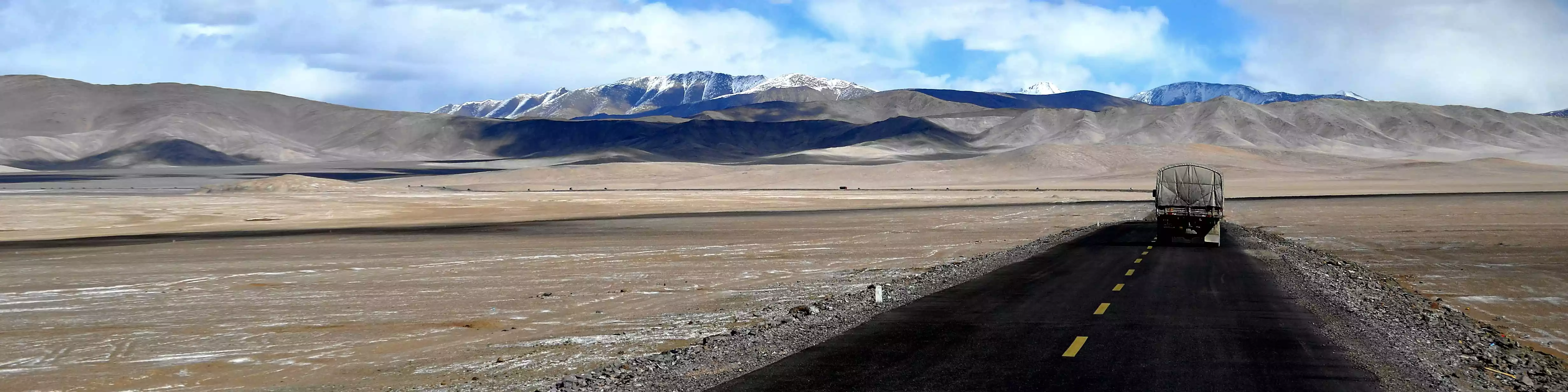
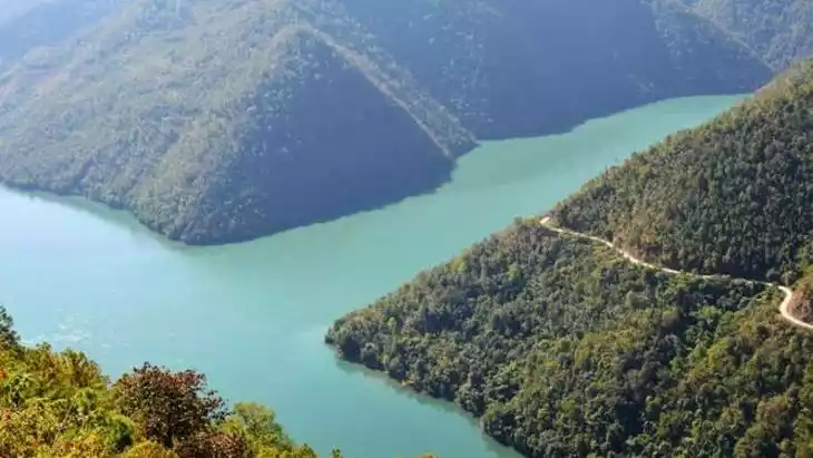
Starting from Jinghong, we sail upstream to Tiger Leaping Rock. There, the river narrows gradually, reaching a narrow spot of only about 20 meters. Jagged rocks line both banks, and the surging river, flanked by jagged peaks, creates a natural spectacle. The lush green waters and lush mountains complement each other, creating a breathtaking natural landscape.
Tickets
free
160 yuan/person (cable car)
Attraction opening hours
All day
Most Popular FAQs for Lancang River
What is the history and significance of this attraction/city?
The Lancang River (in China) is the upper course of the Mekong River, originating in the Qinghai-Tibet Plateau and flowing through Yunnan before entering Southeast Asia. It is a critical river for ecology, hydropower, agriculture, transport, and transnational cooperation (Lancang-Mekong Cooperation). Along its banks are many ethnic communities whose cultures and livelihoods are intimately tied to the river. The river also features dramatic canyons (e.g. Meili Grand Canyon) and is an important natural corridor and scenic resource.
Where is it located and how do I get there (metro, bus, taxi, walking)?
The Lancang River spans multiple provinces in China, especially in Yunnan (through Diqing, Nujiang, Dali, Baoshan, Lincang, Pu’er, Xishuangbanna). For example, in Xishuangbanna, one can start from Jinghong and take river cruises or local boats along the Lancang / Mekong stretch. To reach scenic canyon parts (e.g. Meili Grand Canyon), you travel by road to Deqin / Diqing Prefecture and then approach canyon access roads. Once near the river, local roads, boats, ferries, and hiking paths are used to access viewpoints or riverbanks.
What are the opening hours and best times to visit?
As a natural site, the river is accessible year-round. For boat cruises and tourist shipping, schedules depend on services (e.g., the new Lancang-Mekong international route). The best seasons for scenic beauty and navigation are the wet season / high water months for rafting (May to October) and the shoulder seasons for calmer landscapes and fewer crowds.
What is the entrance fee/ticket price, and how to buy tickets (online/offline)?
Because the Lancang River is a natural corridor, there is no single “entrance ticket” for the whole river. Specific scenic areas (canyons, parks, dam visitor centers) may charge admission. Boat cruises or river tours typically sell tickets via operators (online or at ticket offices).
Do I need to book tickets in advance, and how far in advance?
For popular river cruises or the new international shipping route, booking in advance is recommended, especially in peak season. For rafting tours in canyon stretches, reserve with a tour operator ahead to ensure safety and availability.
How much time is needed to fully explore it?
For a given section (cruise + local stops) you may spend half a day to one full day. For river corridors across multiple prefectures or combining canyon, villages, and boat trip, allow several days.
What are the must-see highlights or main areas inside?
Meili Grand Canyon stretch (steep, dramatic canyon) Rapids and canyon sections for rafting in Diqing / upstream reaches River stretch in Xishuangbanna where the river becomes gentler and forests, ethnic villages line the banks Infrastructure and landmarks such as Jinghong Dam Major bridges (e.g. Lancang River Railway Bridge) for views of river canyon from above
Are guided tours or audio guides available (and in which languages)?
Yes — many rafting / cruise / canyon tours include guides (Chinese and sometimes bilingual) who explain natural features, ecology, local culture. Some larger cruise services or scenic area operators may offer audio guides or multilingual commentary.
What are the best viewpoints or photography spots?
From canyon rims overlooking narrow river gorges (steep cliffs) in Meili Grand Canyon; Bridge vantage points (e.g. from the arch railway bridge) looking down on the river valley; Along riverbanks in gentler stretches (Xishuangbanna) with waterside forests and reflections; From boat on the river, looking toward shores and upstream/downstream transitions.
What is the recommended route or itinerary inside?
For a sample itinerary: start upstream (e.g. Deqin / Meili canyon) → travel downward through canyon stretches → stop at ethnic villages and forests → continue toward gentler river sections (Pu’er, Xishuangbanna) → end at Jinghong port or cross-border points along the Mekong. For day trip: focus on one scenic canyon segment or one cruise segment with local stops.
Are night visits, light shows, or special tours available?
Night river cruises are rare; most river activity is by day for visibility and safety. Some operators may run evening cruises or sunset cruises (check locally). In the international shipping route, overnight passage may occur on multi-day voyages.
Is it crowded, and when are the least crowded times/days to visit?
Key scenic stretches are more visited in high season (summer, holidays). Least crowded times are weekdays, shoulder seasons, early in the day. Remote canyon reaches see fewer visitors by default.
What facilities are available (toilets, food, water, rest areas, shops)?
In major river cruise terminals or scenic area entrances: ticket offices, restrooms, small shops, visitor centers. Along the river route in villages: local eateries, rest stops. On remote stretches: limited facilities; bring water, snacks, supplies.
Is the attraction accessible for elderly, children, or disabled visitors?
Gentler river segments and cruise portions are more accessible. Canyon hiking, steep trails, rafting sections may be difficult for those with mobility issues. Boat segments should be assessed for boarding difficulty.
Is cash needed or are cards/mobile payments accepted?
In more developed towns and tour operators, mobile payments (WeChat Pay / Alipay) are often accepted. In remote villages or small vendors, cash is safer.
What restaurants or cafes are available inside or nearby?
In towns along the river: local restaurants serving ethnic Yunnan cuisine. On boat cruise terminals: snack cafes or small restaurants. Villages along route may offer home-style meals.
Are there vegetarian/vegan/halal food options?
Vegetarian / vegan options (vegetables, tofu) likely available in towns. Halal options may be limited depending on local communities; in larger towns some Muslim restaurants may exist.
What hotels or accommodations are close to the site?
Towns and cities along the river (e.g. Deqin, Lincang, Pu’er, Jinghong) have hotels, guesthouses. In scenic or canyon zones likely guesthouses near river access points.
What other attractions or landmarks are nearby and easy to combine in a day trip?
In Deqin area: Meili Snow Mountain, Tibetan villages. In Xishuangbanna: tropical rainforest reserves, Dai culture villages, botanical gardens. Within Yunnan: tea plantations, ethnic cultural towns, forest parks. Infrastructure landmarks: Jinghong Dam, railway bridge crossings.
Are there souvenir shops and what are the typical souvenirs?
In towns and tourist bases: handicrafts from ethnic minorities (woven textiles, wood carving, local teas, local snacks). River-themed souvenirs in cruise terminals or scenic area gift shops.
What are the best transportation options to continue the trip after visiting?
Continue by road, bus, or private car along the river corridor to the next city. Use river cruise / shipping route (e.g. the Chinese side of Lancang-Mekong cruise) to go downstream to Laos / Thailand. Connect to nearby airports or railheads in cities like Jinghong, Lincang, Pu’er.