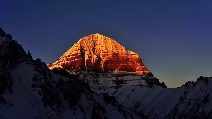
Namunani Peak
What are the most recommended things to do in Namunani Peak?
- Trek to the summit of Namunani Peak for panoramic views of the surrounding Himalayas.
- Photography of snow-capped mountains, glaciers, and alpine meadows.
- Camping at base or mid-altitude camps for sunrise and sunset views.
- Explore nearby valleys and high-altitude lakes.
- Birdwatching and observing local wildlife endemic to the Tibetan Plateau.
Introducing Namunani Peak
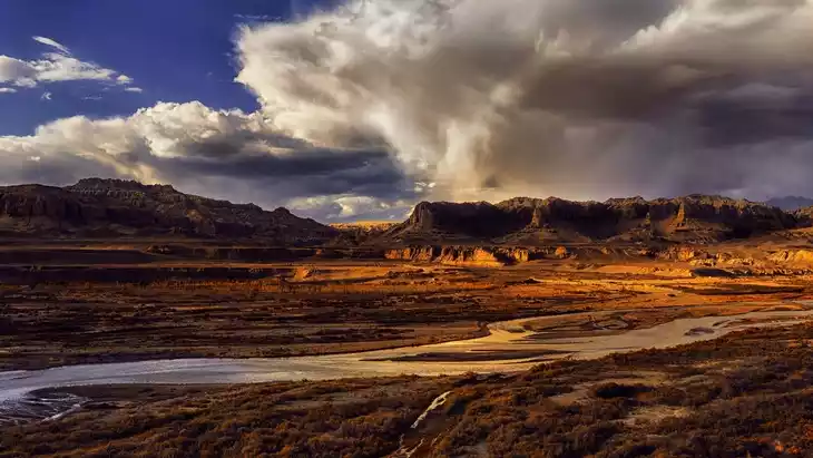
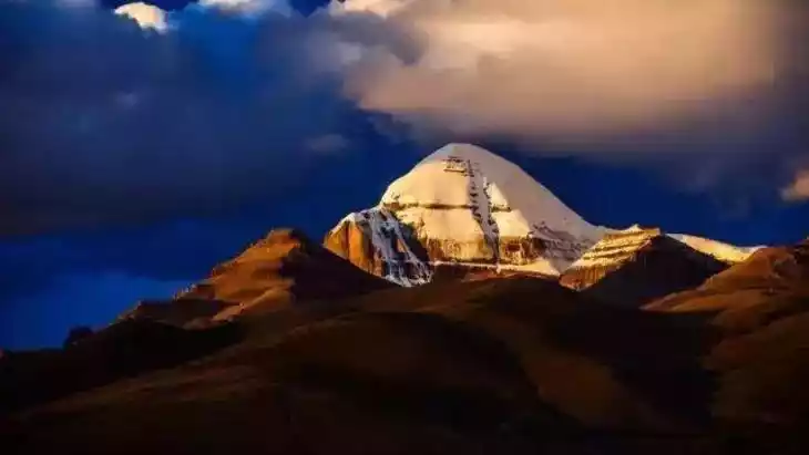
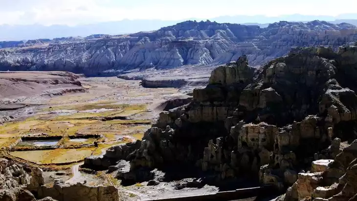
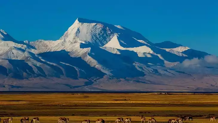
Mount Namunani, at 7,694 meters, is located in Purang County, Ngari Prefecture, Tibet, in the western Himalayas, facing the sacred Mount Kailash at 6,638 meters. Five massive glaciers cascade down the canyon, their surface dotted with crevasses and steep cliffs.
Tibetans call Namuani Peak "Mountain of the Holy Mother" or "Goddess Peak." The western ridges fan out from north to south, while the sole eastern ridge has been eroded into a sharp, sheer ridge, forming a cliff with a drop of nearly 2,000 meters. In contrast, the western slope is more gradual, with five massive glaciers cascading through the canyons, their surface dotted with crevasses and steep cliffs.
Climate and best time to travel
Purang County has a plateau subarctic arid climate, with abundant sunshine and large daily temperature fluctuations. May to late June is a good time for hiking; the rainy season, generally from July to August, is not recommended.
Recommended number of days and locations for visiting
Recommended playing time: about 1 hour
Tickets
free
Attraction opening hours
All day
Most Popular FAQs for Namunani Peak
What is the history and significance of this attraction/city?
Namunani Peak is a high Himalayan peak in Tibet, valued for its natural beauty, trekking potential, and pristine environment. It is culturally significant to local Tibetan communities and often features in adventure and mountaineering activities.
Where is it located and how do I get there (metro, bus, taxi, walking)?
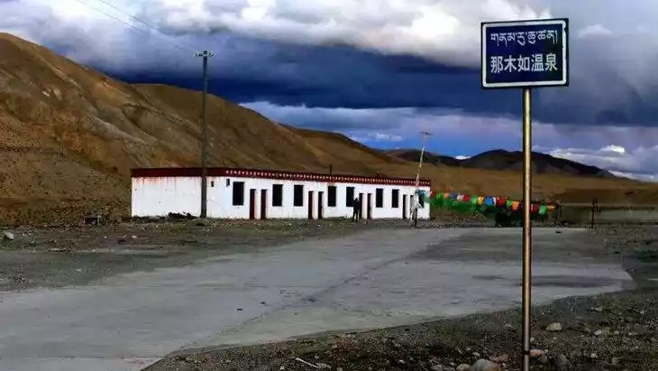
Located in western Tibet, usually accessed via road from major towns like Shiquanhe. Travelers typically reach the base via private vehicle or taxi, followed by trekking to the summit. Public transport is very limited.
What are the opening hours and best times to visit?
Open year-round, but the best visiting season is May to September when weather conditions are safer and trekking routes are accessible.
What is the entrance fee/ticket price, and how to buy tickets (online/offline)?
There is usually no formal entrance fee; permits may be required for trekking, available at local authorities or through organized tours.
Do I need to book tickets in advance, and how far in advance?
Advance booking is recommended for trekking permits and organized tours, ideally 1–2 weeks ahead, especially during peak season.
How much time is needed to fully explore it?
A full trek to the peak and return can take 2–3 days depending on the route and pace.
What are the must-see highlights or main areas inside?
- The summit of Namunani Peak
- Alpine meadows and high-altitude lakes nearby
- Glacial formations along the trekking route
- Panoramic views of the western Tibetan Himalayas
Are guided tours or audio guides available (and in which languages)?
Guided trekking tours are available in English, Mandarin, and Hindi. Audio guides are not commonly provided.
What are the best viewpoints or photography spots?
- Summit of Namunani Peak
- Glacial valleys along the trekking path
- High-altitude lakes and meadows
- Sunrise and sunset spots from ridge lines
What is the recommended route or itinerary inside?
Start from the base camp, trek through alpine meadows and valleys, set up mid-camp if needed, and ascend to the summit early morning for panoramic views. Return via the same route or an alternate safe path.
Are night visits, light shows, or special tours available?
Night camping is possible, providing stargazing opportunities. No organized light shows or special tours are available.
Is it crowded, and when are the least crowded times/days to visit?
The area is generally quiet and uncrowded due to its remote location. Weekdays see fewer trekkers than weekends or peak season periods.
What facilities are available (toilets, food, water, rest areas, shops)?
Minimal facilities; carry your own food, water, and camping supplies. Toilets are available only at base camps.
Is the attraction accessible for elderly, children, or disabled visitors?
Due to high altitude and trekking requirements, it is not suitable for elderly, young children, or disabled visitors without special support.
Is cash needed or are cards/mobile payments accepted?
Cash is necessary for local purchases, permits, and small services. Card or mobile payments are rarely accepted.
What restaurants or cafes are available inside or nearby?
Small teahouses and local eateries exist near base camps or nearby villages, offering basic Tibetan meals.
Are there vegetarian/vegan/halal food options?
Vegetarian options are available; vegan options may be limited. Halal food is not common.
What hotels or accommodations are close to the site?
Guesthouses and small hotels are available in nearby towns or at base camps. Camping is an option for trekkers.
What other attractions or landmarks are nearby and easy to combine in a day trip?
- Nearby high-altitude lakes and valleys
- Other Himalayan peaks in western Tibet
- Local Tibetan villages and cultural sites
Are there souvenir shops and what are the typical souvenirs?
Limited souvenir options; mainly Tibetan handicrafts, prayer flags, and local wool products.
What are the best transportation options to continue the trip after visiting?
Private vehicles or taxis are recommended to return to nearby towns or to continue trekking in the region. Public transport is minimal.