Day 1: Anywhere → or → Lhasa ★Assembly Day★
All day
Today, tourists from all over the country arrived in Lhasa according to their own means of transportation. They will go to the meeting hotel to register their China-TravelNote+name and check in. After checking in, it is recommended that you rest and adjust to the plateau so as to prepare for the rest of the trip.
Don't get too excited when you first arrive in Lhasa! On your arrival day, avoid showering. Drink plenty of water, eat plenty of vegetables and fruits, eat light meals (only until you're 80% full), and stay up late (going to bed early will cause you to wake up in the middle of the night and have trouble falling asleep). Avoid smoking and drinking. A positive mental state is the key to overcoming altitude sickness. Numerous studies have shown that maintaining an open-minded and optimistic attitude can alleviate the physical discomfort caused by altitude sickness.
Tourists in good physical condition can go to the scenic spots in Lhasa. Remember to slow down when traveling in the plateau.
If you feel unwell, please contact your online itinerary manager or group staff immediately for assistance.
Recommended attractions in Lhasa
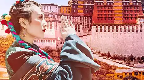
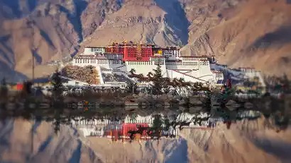
The Potala Palace: A renowned landmark in Tibet, it's an ancient palace complex that combines palaces, castles, and monasteries. Its beauty can't be appreciated from a distance; only up close can its infinite charm be truly felt.
You need to visit the Potala Palace at least 14 days in advance (the specific time is subject to the official mini program, and tickets are released at irregular intervals). You must make an appointment on the Potala Palace ticket reservation mini program. On the day of the visit, you must arrive at the security check at the main entrance of the Potala Palace one hour in advance.
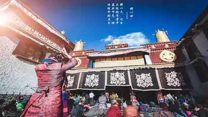
Jokhang Temple: This revered central temple in the Tibetan region. Here, you can experience the Tibetans lighting butter lamps and circumambulating the Barkhor Street. The entire Barkhor Street resounds with the chanting of the six-syllable mantra, "Om Mani Padme Hum," creating a magnificent spectacle. (Visiting the Jokhang Temple requires booking a time slot one day in advance through the Jokhang Temple ticket reservation app. On the day of your visit, present your reservation code at the entrance to purchase your ticket.)
Barkhor Street: After visiting the Jokhang Temple, you can freely stroll through Barkhor Street, boasting over 1,300 years of history. Despite its age, the old city remains remarkably intact, offering a glimpse into Lhasa's urban life. Dinner is free to dine at. Lhasa Kitchen and Snowland Restaurant are both excellent, and Guangming Teahouse offers both sweet and butter tea. The menu offers a wide variety of Tibetan, Nepalese, Sichuan, and Western cuisine.
Sera Monastery: Together with Drepung Monastery and Ganden Monastery, Sera Monastery is known as one of the three great monasteries of Lhasa. They are famous for their debate rituals. The debates take place in the debate arena on the north side of the monastery. The debates are often crowded, so arrive early to secure a good seat.
Drepung Monastery: The white buildings covering the hillside look like a huge rice pile from a distance, hence the name "Drepung". Famous buildings in the monastery include "Ganden Phodrang", "Coqen Hall", and the four major "Zhacang" and its affiliated Kangcun.
Zhaji Monastery: Located on Zhaji Road in the northern suburbs of Lhasa, Zhaji Monastery is a Tibetan temple dedicated to the God of Wealth. Although small, it is incredibly popular, attracting numerous Tibetans and Han Chinese every Wednesday. Zhaji Monastery is a branch of Sera Monastery, a Gelugpa monastery of Tibetan Buddhism, and is free to visit.
Border Pass Related (Must Read)
There are many border checkpoints in Ngari Prefecture. Currently, the document processing hall is mostly used by individual tourists. Group tourists still need to go to the window to process in their own name, which can lead to long queues. In serious cases, it may affect the itinerary. Therefore, tourists are required to apply for a border pass in advance at their registered residence or place of residence, and then go to the nearby police station to provide their second-generation ID card. The pass is usually issued on the spot (subject to the processing time of the police station).
Reason for travel to Tibet: Fill in “tourism”.
Destination: Tibet Autonomous Region, Shigatse Prefecture, Shannan Prefecture, Ngari Prefecture (Must be typed, handwritten is not accepted!!)
Day 2 Lhasa → Yamdrok Lake → Karola Glacier → Shigatse
All day
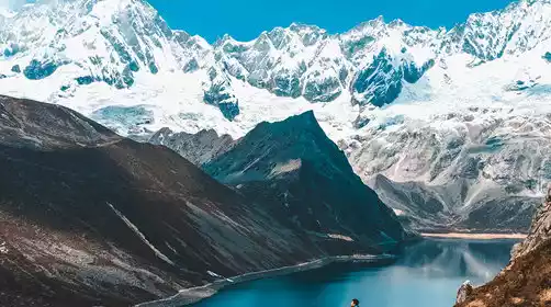
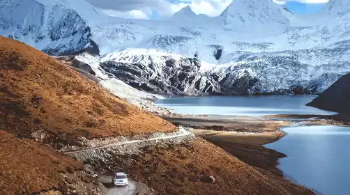
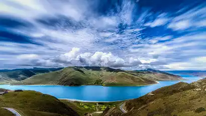
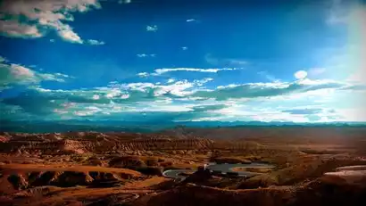
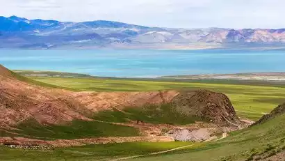
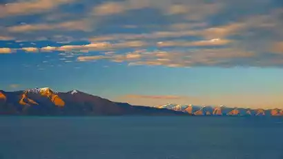
After breakfast, we officially set off, crossing the Gangbala Mountain at an altitude of 4,990 meters, overlooking the Gangbala Radar Station; we followed the old road to Yamdrok Lake, the world's highest freshwater lake, known as the Holy Lake in Heaven. The lake water here is as clear as mutton fat, and the azure blue lake merges into the snow-capped mountains in the distance. The journey was refreshing.
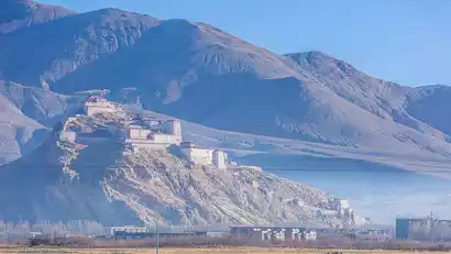
We'll continue along Yanghu Lake, passing through Langkazi County and having lunch. We'll then continue our journey, passing the slumbering ice beauty, the Karola Glacier. This place is not only a geological history written by the passage of time and ice and snow, but also a magnificent work of art sculpted by time! From a distance, we'll admire the site of the heroic anti-British army's battles, Zongshan Fort, and appreciate the charm of this heroic city.
Arrive at Shigatse, a major city in western Tibet, in the evening and check in to the hotel for rest.
Day 3 Shigatse → 5000m Square on National Highway 318 → Sakya Monastery → Mount Everest Scenic Area
All day
Depart at the right time after breakfast at the hotel
Passing the 5000km square on National Highway 318, we arrived at Sakya Monastery, the main temple of the Sakya sect of Tibetan Buddhism. The walls of Sakya Monastery are painted with red, symbolizing Manjushri Bodhisattva; white, symbolizing Avalokitesvara Bodhisattva; and blue, symbolizing Vajrapani Bodhisattva. Therefore, the Sakya sect is also commonly known as the "Flower Sect".
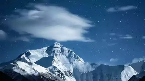
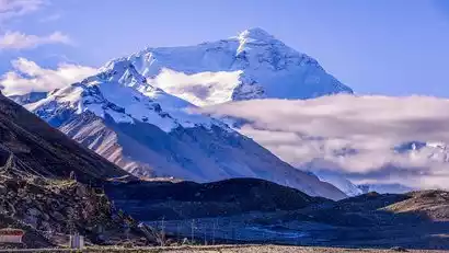
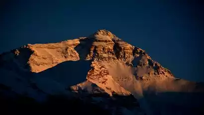
We then continue towards the Himalayas, passing the Xilin Observation Deck and the Makalu Observation Deck, arriving at Basong Village, a village at the foot of Mount Everest. We'll then transfer to the Everest Scenic Area's eco-friendly bus to Everest Base Camp for photos. You can first visit Rongbuk Monastery, the world's highest temple (at your own expense), and then take a photo at the Mount Everest stele. If the weather is good, you can also wait for the sunset at Mount Everest. Remember to descend before the last bus departs.
After going down the mountain, return to Basong Village Hotel or B&B to rest.
Day 4: Mount Everest Scenic Area → Gawu La Pass → Mount Everest Fortress → Pekutso → Asia No. 1 Observation Deck → Jilong Town
All day
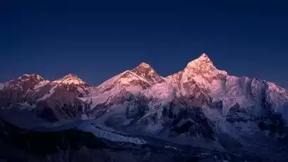
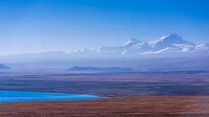
Today we need to get up early and go to Gawu La Pass to watch the Himalayan sunrise. If you are lucky, you can see four snow-capped mountains over 8,000 meters from here, namely: Makalu (8,463 meters), Lhotse (8,516 meters), Mount Everest (8,844 meters), and Cho Oyu (8,201 meters). Here, the snow-capped peaks are in full view, and life is nakedly facing the majesty of the world and the universe. Then, drive out of the Mount Everest Scenic Area along the 108 bends of Mount Everest and head to Old Dingri (Gangga Town).
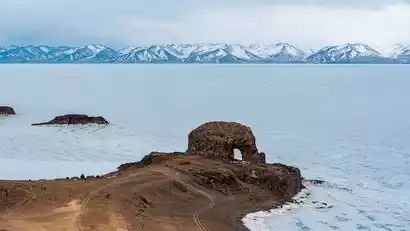
After arriving in Lao Dingri, we headed to the ruins of Mount Everest Castle. As a historical relic, although most of the castle has been eroded by wind and rain, you will still be shocked by the relics left by time. It is also a very good viewing point for Mount Everest.
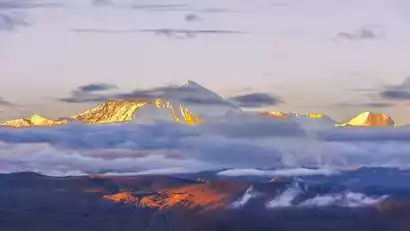
Continuing along Highway G219, we came upon Shishapangma, the "Auspicious Sacred Mountain," at 8,027 meters. We gazed at the snow-capped peak, shimmering in the sunlight, its majestic majesty. We then reached the shores of Peikucuo Lake, admiring the magnificent natural scenery. It's said that anyone who can capture Shishapangma from Peikucuo will be blessed with good fortune. While this is just a legend, the blessing of the snow-capped mountain and lake has intensified our desire to explore.
Then we will enter Jilong and go to the "Asia No. 1 Observation Deck", which is known as "Asia No. 1" because it can offer a full view of the magnificent snow-capped mountains.
The road leading to Asia No. 1 Scenic Area is currently under construction. If this is impassable, we will visit Jeep Canyon instead.
After taking some photos, we returned to Jilong Town to check in.
Day 5 Jilong Town → Nai Village → Saga → King Peak → Zhongba
All day
After breakfast at the hotel, we'll depart for Nai Village in Jilong Town (approximately a 30-minute drive. Weather permitting, we'll be happy to wake up early to watch the sunrise). Nai Village means "holy place on the top of a mountain" in Tibetan. The natural scenery here is magnificent, with grasslands, snow-capped mountains, forests, clouds, sunrises, and the idyllic scenery of the plateau. The rural Tibetan dwellings create a sense of paradise.
After the tour, return to Jilong Town and depart for Saga. Have lunch and rest in Saga County.
After lunch, we'll head to King Peak (Pulaxiqiong) in the Gangdise Mountains. King Peak, at approximately 6,530 meters above sea level, is a satellite peak of Lengbugangri (7,095 meters), the highest peak in the Gangdise Mountains. Its shape resembles a pyramid frozen in Tibet, a majestic and mysterious presence. In local legend, Lengbugangri is known as the "Minister's Snow Mountain," while Pulaxiqiong is the "King." The two are considered brothers, jointly protecting this sacred land.
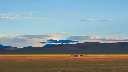
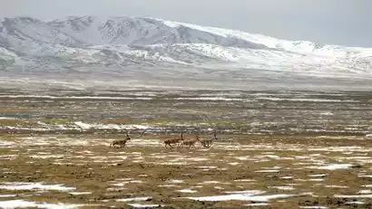
If we are lucky, we will see wild animals such as Tibetan wild donkeys from afar, and take pictures of the vast snow-capped mountains and grasslands along the way, as well as the herds of yaks.
Then we returned to National Highway 219 and drove along the asphalt road of the southern Ali line, arriving in Zhongba County in the evening to check in.
Day 6 Zhongba → Zhongba Sand Dunes → Mayumula Pass → Wild Yak Valley → Lake Manasarovar → Lake Laangtso → Tachin
All day
Today, we will officially enter the "Secret Land of Western Tibet, Heavenly Ali"
After setting out from Zhongba County, you can see the Maquan River, the upper reaches of the Yarlung Zangbo River, on the left side of the road. Continuing forward, you will see the Zhongba Sand Dunes.
Travel along National Highway 219 to the gate of Ngari Prefecture. After crossing the Mayumula Pass (5,200 meters above sea level), the azure Gongzhutso Lake will appear on the left side of the road. The grasslands beside the lake are fertile and there are herds of cattle and sheep.
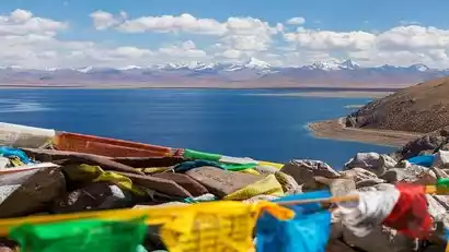
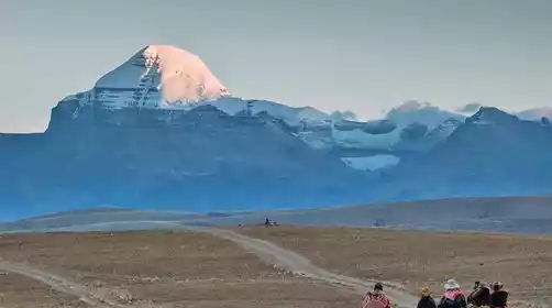
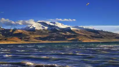
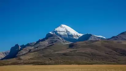
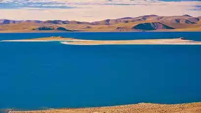
After passing Gongzhu Co, Mount Namnayi soon comes into view, with Mount Kailash just around the corner. Mount Kailash, meaning "Mountain of the Gods" in Tibetan, resembles the icy crown of a pyramid. Though modest in height, it possesses a breathtaking aura. Nestled alongside Mount Kailash are the sacred lakes of Manasarovar and Lhakhang Co, two closely connected yet distinctly different sister lakes. Lake Manasarovar is as smooth as a mirror, its vast expanse azure blue, and its shores are frequented by pilgrims. Meanwhile, just across the hill, Lhakhang Lake is turbulent, haunted, and deserted. These two lakes were originally one, but climate change has caused them to recede, creating two separate lakes.
We will first be led by the staff to a secret place which we call "Wild Yak Valley". Wild yaks can be seen here most of the time. We can watch and photograph the wild yaks here, and then return to visit the sacred mountain and holy lake.
Today we stayed at a hotel at the foot of Mount Kailash.
Day 7 Taqin → Silver City → Malang Canyon → Guge Kingdom → Zanda
All day
Today we depart, bid farewell to the sacred mountain Mount Kailash, and head to Zhada [Qionglong Silver City].
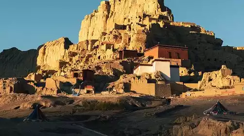
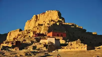
The Dome Silver City, shaped like a roc, was the first of the eighteen empires of the ancient Zhangzhung Empire. We ascended the scenic plank path, reaching the summit where the remains of a red-walled palace stood. On either side, caves dotted the colorful earth forests. The Langchen Zangbo River flowed gently before the ruins, and a hot spring perpetually steamed through its midst. The calcification of the hot spring has created a myriad of bizarre rock formations.
We then entered the territory of Zhada. As the vehicle drove on, your soul was slowly overwhelmed by the scenery before you, amazed by the wonders of nature's creation. Is this Earth? It felt like being on a planet in outer space, desolate, majestic, and with incredible shapes. Arriving at Malang Canyon, the scenery was even more extraordinary. Descending to the bottom of the canyon, another wonderful scene was revealed: lush green, the occasional leap of life, and an endless vitality. Yet, the surface was crystal clear, and the tranquil river merged with the surrounding earth forest.
In the afternoon, we will arrive at the Guge Kingdom, where is the birthplace of the ancient Ali civilization. The Guge Kingdom was once prosperous, but it suddenly disappeared without a trace around the 17th century, leaving only a few records and various mysterious legends.
Stay in the heart of Ali - Zhada County at night!
Dear friends, Zada is the center of the ancient Ali Kingdom. Come and have a good sleep under the starry sky~
Day 8: Zhada → Toling Monastery → Xiayi Valley → Shiquan River → Pangong Lake → Rutog
All day
Today we will visit Toling Monastery, the first Buddhist temple built in Ngari during the Guge Kingdom (10th-17th centuries AD). Toling, meaning "flying in the sky," was a key site for the Guge Dynasty to promote Buddhist culture.
Afterward, we'll drive to the Zada Earth Forest National Geopark (Xiayigou), a place rarely seen by even locals. Instead of admiring the magnificent earth forest from a distance, we'll experience its exquisite beauty up close.
When we pass through Shiquanhe Town, we will go to the Ali Prefecture Culture and Tourism Bureau to receive the "Warrior Certificate" issued by the official on-site.
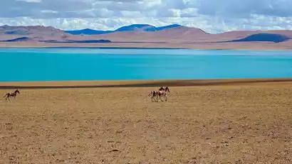
Then we went to visit the red wave of Comu Ngla [Pangong Tso], which is located about 12 kilometers northwest of Rutog County in Ngari Prefecture. The peculiarity of Pangong Tso is that the water of the lake is fresh water, brackish water and salt water from east to west. The water of the lake in my country is turquoise, with good water quality and abundant products. Wild animals can be seen roaming nearby.
Check in tonight at the hotel in Rutog County.
Day 9 Ritog → Shiquanhe → Cuonacuo → Yare → Renduo
All day
Today we will enter the vast uninhabited area, starting from Rutog and passing through Geji and Yare. Many wild animals such as wild yaks, Tibetan antelopes, Tibetan gazelles, wolves, Tibetan wild donkeys, etc. will appear in our sight.
In the afternoon we passed by the Comaguso Lake in Yare Township, a beautiful saline lake, and arrived at Renduo Township in the evening to check in.
Day 10: Renduo → Renqing Xiubucuo → Zhabuye Chaka → Cuoqin
All day
Today, you'll see numerous lakes dotted with stars along the way, allowing you to experience the grandeur of "making one mistake after another." Yesterday's beauty was just a prelude, and today's stunning scenery will be even more amazing.
After departing from Renduo Township, we'll pass Renqingxiubucuo, a lake hailed by locals as a paradise on earth, and the stunning and mysterious plateau salt lake Zhabuye Chaka, home to the world's third-largest lithium deposit. In addition, there are many smaller lakes, less famous or even unnamed, yet equally captivating.
Arrive at Coqen County in the evening and check in.
Day 11: Cuoqin → Zhari Nam Co → Dangre Yong Co → Wenbu Nan Village
All day
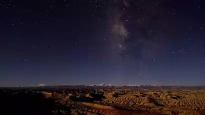
We got up early and set off for the mysterious northern Tibet, the largest lake in Ngari [Zhari Namtso], with dust all the way.
In the afternoon, we arrived at the ancient holy lake [Dangre Yumco] worshipped by Bon believers. It is also the third largest lake in Tibet. It is shaped like a shoe sole and is surrounded by mountains on three sides.
We will spend the night at Wenbunan Village, next to Dangre Yongcuo, one of the most beautiful lakes on the northern line of Ali.
With a sky full of stars and a tranquil lake, you will find that this is paradise.
No. 12 Tianwenbunan Village → Dazecuo → Wurucuo → Selincuo → Bange
All day
In the morning, photograph the stunning sunrise at Dangre Yumco Lake. Then, journey along the beautiful grasslands to Nima County and continue to Daze Co Lake, a haven for Tibetan antelopes. You'll spot a variety of wildlife along the way! Today's main attraction is the lakes and snow-capped mountains. The stunning scenery of these lakes is sure to captivate you. Selin Co Lake, Tibet's largest and China's second-largest saltwater lake, is also home to the renowned Black-necked Crane Breeding Nature Reserve. While the road conditions may be poor today, the breathtaking scenery will surely ease your fatigue. Before you know it, you'll arrive in Bange.
Day 13 Bange → Bange Tso → Holy Elephant Gate → Nagen La Pass → Lhasa
All day
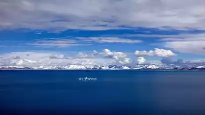
In the morning, we set off for the Holy Elephant Gate. Driving along the Qinghai-Tibet Highway, we admired the scenic grasslands and pastures of northern Tibet. Arriving at the Holy Elephant Gate, we found the renowned Chadu Namtso Island on the northern shore of Namtso. From a distance, the Namtso shoreline formed two arcs, with a massive rock rising abruptly in the middle. Up close, it resembled an elephant. This angle offered a uniquely beautiful view of Namtso, and few tour groups visited. After our visit, we departed the scenic area, with the Nyainqentanglha Mountains visible to the right of the car window.
[Special reminder] Shengxiang Tianmen Scenic Area is currently in the individual reservation state. If it is not possible to reserve Shengxiang Tianmen Scenic Area for all members, we will go to Namtso [Zaxi Peninsula] Scenic Area
We will return to the holy city of Lhasa to end the activities. We will arrive back to Lhasa late that night. Accommodation is included tonight.
Day 14 Lhasa ★ All day Disbandment day ★
All day
Today is the day of disbanding. We will bid farewell to our beautiful holy city Lhasa according to our flight or train schedule.
If you have time, you can go to Barkhor Street on your own and bring back some gifts for friends and family. However, you should bargain sincerely and use your own taste. Our advice is: enjoy small purchases, but be cautious with expensive items.