
Day 1: Across the country → Lhasa
All day
Today is the all-day gathering day. All tourists will go to the Lhasa city center to gather at the hotel.
After checking in, tourists are advised to rest and adapt to the plateau and prepare for the rest of the trip.
Tourists in good physical condition can go to Barkhor Street for a walk. It is important to slow down and maintain a calm mindset when traveling on the plateau.


Day 2 Lhasa → Jiali County → Jianai Yucuo → Jiali County
All day
Hiking Information
Hiking route: Jianai Yucuo (4500m);
Hiking distance: about 4-8KM;
Hiking time: 4-5 hours;
Meal information: It is recommended to bring your own meals;
Luggage Information: Travel light and carry only the essentials for the day of hiking.
Today's itinerary
Starting from Lhasa and heading east, we pass through Medog County.
This is the location of Zhigongti Temple, the founder of the Zhigong Kagyu sect of Tibetan Buddhism. Continue forward and enter Jiali County.
[Jiali County] is a small town surrounded by snow-capped mountains. It was once an important post station on the ancient Tea-Horse Road. Today, it is still well-connected, with three national highways passing through it, making it a fortress in eastern Tibet.
In the afternoon, depart from Jiali County and head to [Jianai Yucuo].
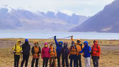
Jianaiyucuo is a plateau lake in Jiali County. The lake water is crystal clear and is surrounded by vast grasslands and continuous snow-capped mountains. The scenery is spectacular.
We conducted an adaptation hike by the lake and learned how to use trekking poles and other outdoor knowledge related to plateau walking.
P.S. Hiking Option 1: Walk along the lakeside starting point, circle halfway around the lake to the bus pick-up point; Hiking Option 2: Walk along the lakeside starting point to the temple, check in and return to the bus (first day of plateau hiking, choose adaptive hiking according to personal conditions)
Day 3 Jiali County → Bada Village → Bunanggou Hiking → Niwu Township
All day
Hiking Information
Hiking route: Bunanggou Hiking (4400m);
Hiking distance: about 10km, climbing 400m;
Hiking time: 4-5 hours;
Meal information: It is recommended to bring your own meals;
Luggage Information: Travel light and carry only the essentials for the day of hiking.
Today's itinerary
Starting from Jiali County, follow the county road to Bada Village and enter the valley
Continue driving for about 8 kilometers to reach the starting point of the hike. On the way, you can enjoy the plateau scenery of eastern Tibet.
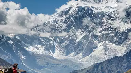
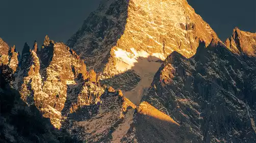
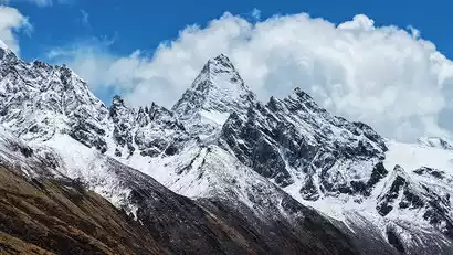
Starting from the hiking starting point, enter the [Bunanggou] for hiking. The hiking distance is about 8 kilometers, with the highest altitude of 4,800 meters. The whole journey is extremely pristine.
There are three beautiful pyramid-shaped peaks in the Bunang Valley: Kagaqiao Peak (6447 meters), Manazhuo Peak (6264 meters) and Zasolluzan Peak (6144 meters).
Because of its unique conical mountain, its shape is as unique as the Matterhorn. During the hike, you can enjoy the magnificent snow-capped mountains, glacial lakes and rich plateau vegetation.
After the hike, we will go to Niwu Township. Tourists who still have energy can take a walk to "Lharibenpa", one of the four white pagodas of the "Nyingma School" of Tibetan Buddhism after lunch.
Day 4: Tianniwu Township → Yiga Glacier → Bianba County
All day
Hiking Information
Hiking route: Yiga Glacier Hiking;
Hiking distance: about 4KM;
Hiking time: 2-3 hours;
Meal information: It is recommended to bring your own meals;
Luggage Information: Travel light and carry only the essentials for the day of hiking.
Today's itinerary
Depart from Niwu Township and take an off-road vehicle for about 3 hours to reach the foot of the glacier
When the weather is good, you can see the first wave along the way.
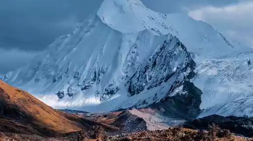
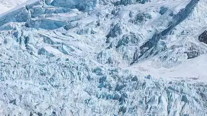
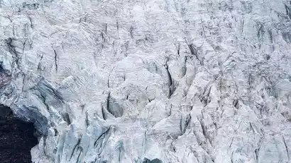
Head to Yiga Glacier, known as the glacier growing on the forest;
At Yiga Glacier, travel light and experience the charm of the glacier up close
A giant glacier tongue tens of kilometers long cascades down the mountain along the canyon.
It was like being paused suddenly. This scene was really more shocking than the ancient glacier.
Finally, we will go from Yiga Glacier to Bianba County, where we can enjoy the natural scenery of the plateau along the way.
Day 5: Tianbianba County → Sap Holy Lake → Sap Base Camp
All day
Hiking Information
Hiking route: Hiking to Sapu Mountain and Holy Lake;
Hiking distance: about 10KM;
Hiking time: 5-6 hours;
Meal information: It is recommended to bring your own meals;
Luggage Information: Travel light and carry only the essentials for the day of hiking.
Today's itinerary
Depart from Bianba County and arrive at Sapu Sacred Mountain and Holy Lake
Take a sightseeing bus from the entrance of the scenic area to the base camp of Sapu Mountain
After a short rest, we will walk along the lake and head towards the ice lake.
You can adjust according to your physical condition. If you are physically fit, you can return to the base camp to rest.
Wait for the sunset, and if the weather is good, you can also see the brilliant starry sky of Sap at night

Day 6: Sap Base Camp → Burang County → Dam Monastery Skull Wall → Nagqu County
All day
Today's itinerary
After waking up early to watch the sunrise, we set off from [Sap Base Camp]
After a section of dirt road, we arrived at Biru County
Starting from Biru County, take National Highway 317 to Nagqu County
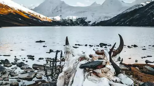
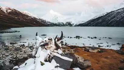
Stop at the [Dam Temple Skull Wall] on the way
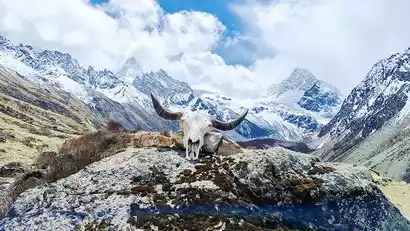
At the Damu Temple, 4,500 meters above sea level, the mysterious and solemn sky burial platform and skull wall
The vast wilderness of the northern Tibetan Plateau coincides with the "birth and death" of life.
Here, you can appreciate and respect life.
We will fully experience the scenery of the northern Tibetan grasslands and the flora and fauna of the plateau along the way. We will stop by the roadside to appreciate and take pictures when appropriate.
Nagqu County is the center of the northern Tibetan Plateau and one of the famous Cordyceps production areas.
Rest in Nagqu at night


Day 7 Nagqu County → Namtso Scenic Area → Nagen La Pass → Dismissal in Lhasa
All day
Hiking Information
Hiking route: Namtso hike;
Hiking distance: about 2KM;
Hiking time: 1 hour;
Meal information: It is recommended to bring your own meals;
Luggage Information: Travel light and carry only the essentials for the day of hiking.
Today's itinerary
This morning was quite hard
Depart from Nagqu County at 7 o'clock and take the G317 National Highway to [Namtso Scenic Area]
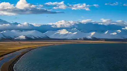
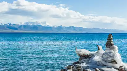
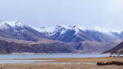
After arriving at Namtso Scenic Area, visit Namtso Lake and admire the azure waters of the lake and the distant Nyainqentanglha Mountains.
Namtso Lake is 4,718 meters above sea level and is one of the three sacred lakes in Tibet.
There are Mani piles and prayer flags by the lake, and many waterfowl live in the lake.
After visiting Namtso Scenic Area, we headed to Nagenla Pass, which is the only way to Namtso.
At Nagenla Pass, you can overlook the panoramic view of Namtso Lake and feel the grandeur, vastness and vastness of the plateau.
There is a stone tablet at the mountain pass indicating the altitude, and the Mani piles are hung with prayer flags, symbolizing the Tibetan people's reverence for the gods.
Finally, after arriving in Lhasa, the trip ended and the group disbanded.