Day 1 Various locations - Kashgar (★Activity gathering day)
All day
Today is the gathering day for the event. Tourists from all over the country will check in at their hotels in Kashgar, the heart of southern Xinjiang. Simply provide "China-Travel Note + Name" to check in.
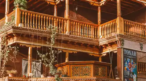
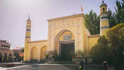
If you have more time, you can plan your own activities in Kashgar. We recommend a free stroll through Kashgar Old Town. In Kashgar Old Town, you can visit the Id Kah Mosque, the largest in China (admission not included). For Muslims, it's not just a place of worship; it's a spiritual haven. Kashgar Old Town boasts a maze-like network of houses, all constructed in a monolithic, earthen, and brick-and-wood Islamic style. The streets are intricate and labyrinthine, and the century-old teahouse on the corner was a filming location for the movie "The Kite Runner." In the evening, discover local delicacies at the Khan Bazaar, the Old Town night market.
Border Pass Description: (Updated on August 11)
The team will go to D2 to apply for a border pass, one per person (bring ID card, apply in person); children under 16 years old: must be accompanied by their parents (bring household registration book + ID card).
Kind tips:
The off-road route goes deep into the Karakoram Mountains, offering a more niche experience! One night's accommodation in a local farmhouse with shared bathrooms is perfect for adventure lovers!
Day 2 Kashgar → Border Pass Application → Karakoram Highway → Baisha Lake North Shore → Muji Township Crater → Bulunkou Township
All day
[Beijing time 9:30-9:45] Wait in the hotel lobby. The driver will pick you up and you will first go to apply for a border pass (you need to bring your ID card/household registration booklet, see D1 instructions for details), then the journey will officially begin.
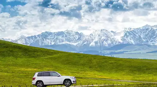
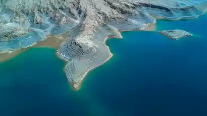
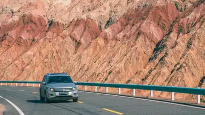
We traveled along the Karakoram Highway, a friendship highway between China and Pakistan, towards the Pamir Plateau. "Pamir" means "Roof of the World" in Tajik, and the ancient Silk Road passed through this region. Along the way, we admired the magnificent Aoyitake Red Mountain, also known as the "Flaming Mountains of Southern Xinjiang" (a drive-through). As we continued our journey, we stopped by the north shore of Baisha Lake for photos. Compared to the more touristy south shore, this spot offers a magical juxtaposition of blue lakes and sand dunes.
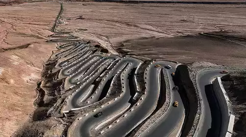
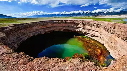
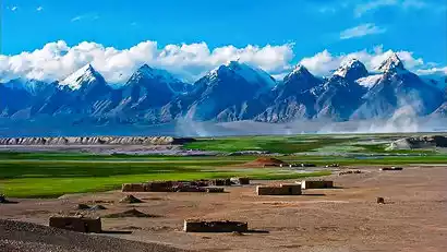
In the afternoon, we arrived at the mysterious border village of Muji Township, home to the unique Kare Temir Volcanic Cluster, with 13 craters formed by eruptions 1,500 years ago. Marvel at the magical charm of nature with its iconic craters, rare plateau wetlands, clear glacial lakes, and sweet glacial water. In the distance, the snow-capped mountains, lined up in a row, are known as the "Eighteen Arhats Snow Mountain Honor Guard," guarding this secret plateau landscape.
Day 3: Bulunkou Township → Karakul Lake → Tree Hole Road → Taheman Wetland → Khunjerab Pass → Tashkurgan County
·morning
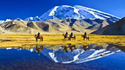
After breakfast, we will depart for Karakul Lake to admire the reflection of Muztagh Ata, the "Father of Glaciers," at 7,546 meters above sea level. You can also photograph the three Kunlun Mountains reflected in the lake: Kongur Peak at 7,649 meters above sea level, Kongur Jiubie Peak at 7,530 meters above sea level, and Muztagh Ata Peak at 7,509 meters above sea level.
Afterward, China-TravelNote will take you on a privately-built, off-the-beaten-path route, admiring the "Tree Hole Road" beneath the snow-capped mountains. Stretching for several kilometers, the road is lined with unique plateau trees, their branches connected at the top. Passing through these tree holes creates a sense of time travel. Continuing on, we'll explore the Taheman Wetland, admiring the wetlands and grasslands nurtured by the meltwater from the Muztagh Ata glacier.
·afternoon
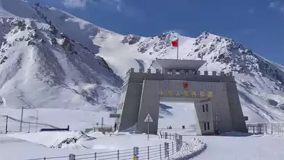
After lunch, we will head to Khunjerab Pass. Khunjerab means "blood-stained passage" in Tajik. It is the highest national gate in my country. There are only more than 80 days of frost-free period a year, and it is covered with snow even in summer.
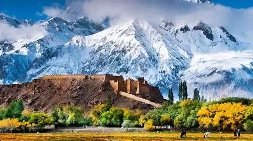
We arrived in Tashkurgan County that evening. This small border town (around 3,000 meters above sea level, with little altitude sickness) is primarily populated by the Tajik people, who are known for their unparalleled reputation for not picking up things on the road and leaving their doors unlocked at night. This is a noble ethnicity on the Pamir Plateau. That evening, we met up with our group to explore the plateau's unique cuisine (yak hotpot, yak beef, etc.).
Day 4: Tianta County → Panlong Ancient Road → Tasha Ancient Road → Bandir Blue Lake → Alemalek Village (Xinghua Village) / Tashi County
All day
We will set off after breakfast. If the Panlong Ancient Road is open, we will cross the Panlong Ancient Road, a popular plateau highway. It has hundreds of hairpin turns and winds down. I believe everyone will be shocked by the strength of the road builders.
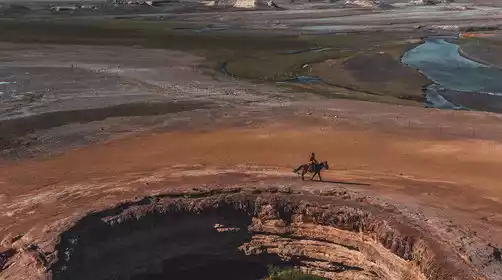
Afterwards, drive into the [Tasha Ancient Road] and follow the route that Xuanzang took on his return journey to the west, deep into the Kunlun Mountains. Passing by the Bandir Blue Lake, where meltwater from the snow-capped mountains converges, it looks like a huge blue gem embedded in the heart of the Kunlun Mountains.
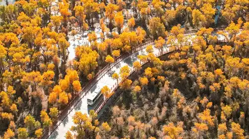
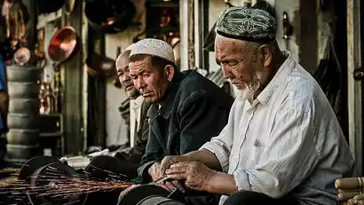
In the afternoon, we arrived at Alemalek Village. In spring, apricot blossoms blanketed the mountains. We visited local Tajik families and arranged some simple home visits to learn more about the Tajik people, known as "China's only Caucasian people." Thanks to the Party's policies, nomadic herders living in the mountains now have new, ethnically distinctive houses and clean, modern homes. The simple Tajik villagers warmly welcomed our visitors from afar, and we might even share a Tajik dance.
Tonight, we stayed at the home of a Tajik fellow villager and experienced authentic Tajik life.
Important Notes (Updated July 9):
1. The Panlong Ancient Trail is at a high altitude and has many continuous bends. It may be temporarily closed in case of snowfall. If it is impossible to cross it, you will have to give up the trip and increase the time spent in the Tajik village. Thank you for your understanding.
2. The second half of the Tasha Trail is currently closed due to landslides! The Tasha Trail runs through the Karakoram Mountains, with steep terrain and complex road conditions. Landslides and road closures are common in the Tal Township-Shache section.
Alternative plan: On Day 4, return to Tashkurgan County from Alemalek Village along the same route to stay overnight. On Day 5, abandon the second half of the Tasha Ancient Road and return to Shache along the same route. The difference in accommodation prices, increased fuel costs, and driver fees will be borne by China-TravelNote.
Day 5: Alemalek Village → Tasha Ancient Road (Scenic and Cultural Scenery Along the Way) → Yarkand
All day
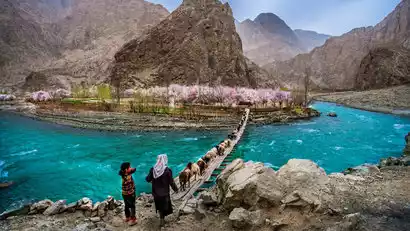
After breakfast, we'll set off today, continuing our journey through the Kunlun Mountains. We'll stop and go along the Tasha Ancient Trail, deep into the heart of the Pamir Plateau. The quaint villages and towering Karakoram Mountains whizz by on either side of the off-road vehicle, accompanied by the simple Tajik customs, create a cozy and comfortable experience. The deeper we go into the mountains, the more we feel the warm and friendly Tajik people. We'll chat with them and learn about their lives.
In the evening, we will cross the Karakoram Mountains and arrive at the hotel to check in and rest.

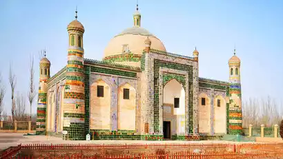
Day 6 Shache → Yarkand Khan Palace or Yarkand Khanate Mausoleum → Taklamakan Desert → Wuqia County
·morning
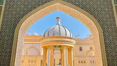
After breakfast, we will leave for Yarkand Khan Palace (also known as Shache Intangible Cultural Heritage Expo Park), a film and television base built on the site of the former Yarkand Palace. The exquisite brick carvings, arches, domes, symmetrical figures, regular patterns, and colorful colors perfectly restore the luxury of the Islamic-style palace.
Important Notes:
The Yarkand Khanate Palace is currently under renovation and is temporarily closed for maintenance. We will change our itinerary to visit the Yarkand Khanate Mausoleum. Thank you for your understanding!
·afternoon
We then drove to the Taklamakan Desert, the largest desert in China. We arrived at the N39 Desert Camp, where we could climb sand dunes for a panoramic view, or experience the thrill of a UTV off-road trip (at our own expense), where we could go deep into the desert and surf.
After having fun, we headed west to Wuqia County, the westernmost county in China, and checked into the hotel to rest.

Day 7 Wuqia County → Fossil Mountain → The intersection of two mountains → Westmost Monument → Simhana Village → Irkeshtam Port → Kashgar
All day
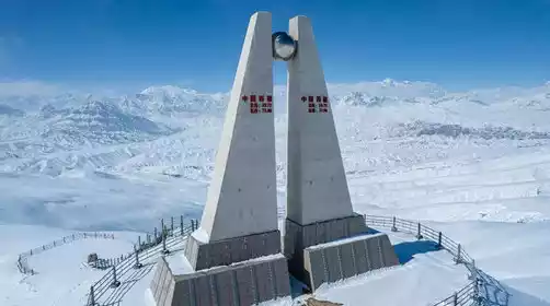
Today we will head towards the [Westernmost Point of China] along the border road between China and Kyrgyzstan!
Stop by Fossil Mountain for photos. This mountain range is renowned for its rich fossil reserves and is known as the "Home of Dinosaurs in China." The area preserves a rich variety of paleontological fossils, including dinosaurs, mammals, and reptiles. The mountain's unique shapes and cascading rock formations create a sense of grandeur and mystery, allowing you to experience the wonders of geological evolution.
As we continued westward, the majestic Kunlun Mountains loomed on our left, while the 2,500-kilometer-long Tianshan Mountains stretched to our right. These two vast mountain ranges gradually approached and converged here. We arrived at the Tianshan + Kunlun Mountain Intersection Observation Deck, where the Tianshan Mountains appeared camel-colored and the Kunlun Mountains dark blue. We took in the unique features of these two great mountain ranges at a glance, and experienced the vigorous mountain-building movement.
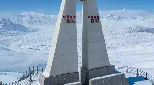
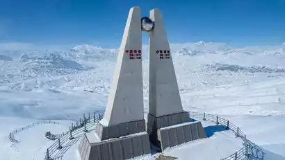
In the afternoon, we arrived in Jigen Township, China's westernmost township, and headed for the Westernmost Boundary Monument. We climbed to the Last Ray of Sunshine Observation Deck at the summit, overlooking the Kunlun Snow Mountain. At the foot of the mountain, the Irkeshtam Port, a crucial passage between China and Kyrgyzstan, was bustling with traffic, transporting supplies. This is where the sun sets last in China!
After going down the mountain, we headed to the last village in the west, Smukhana Village, and took photos at the Irkeshtam Port (the port is strictly inspected, so you can take photos from a distance outside and not enter the port).
Leave at the right time and return to Kashgar Hotel to rest.
Day 8 Kashgar - Various locations (★Event end date)
All day
Today is the day for the whole day to disband. Everyone left Kashgar reluctantly according to their respective travel times and returned to their warm homes.
If you are interested in the culture of southern Xinjiang, it is recommended to stay in Kashgar for one more day.
Kind tips:
Check-out time for Xinjiang hotels is 2:00 PM. Kashgar Airport is approximately 9 kilometers from downtown and costs about 30 yuan by taxi.