
Day 1: All Locations → → Korla (★All-day gathering day)
All day
Tourists from all over the country, heading to Korla, the gateway city of southern Xinjiang, go to the meeting hotel on their own and report "China-Travel Note + Name" to the front desk when checking in.
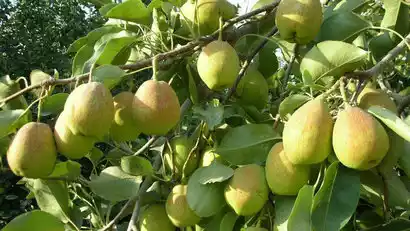
Korla, a strategic point along the ancient Silk Road's Central Route, is also known as the "Pear City" for its renowned "Korla Fragrant Pear." Early arrivals can visit the Bazhou Museum and encounter the Loulan beauties unearthed from the Lop Nur ruins; stroll along the Peacock River and encounter migrating wild swans; and in the evening, savor freshwater fish from Bosten Lake. Korla's red willow barbecue is also excellent.
Border Pass Description:
The team will go to D6 to apply for a border pass. Each person has one pass (bring your ID card and apply in person)
Children under 16 years old: must be accompanied by their parents (bring household registration book + ID card)
Traffic Tips:
Korla Railway Station: There is an intercity high-speed rail from Urumqi Station to Korla Station, which takes 3-4 hours. The railway station is not far from the city center.
Korla Airport: It has domestic flights and is not far from the city center. A taxi is about 30-45 yuan. It is easy to get a taxi.

Day 2 Korla → Luntai Populus euphratica forest → Kuqa
All day
After breakfast, we headed west, with the majestic Tianshan Mountains on the right and the Tarim Basin, China's largest basin, on the left.
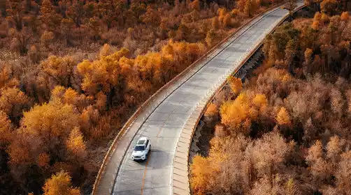
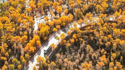
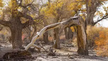
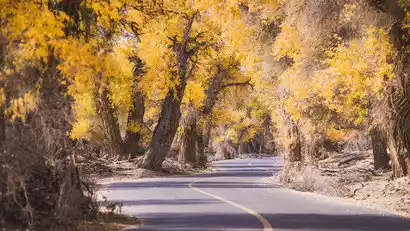
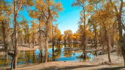
In the afternoon, we'll arrive at the renowned Luntai Tarim Populus euphratica Forest Park, home to the largest pristine poplar forest in the Tarim River basin, home to over 90% of the world's poplars. We'll take a scenic bus deep into the forest, then take the scenic train (at your own expense) or stroll along the train tracks, taking photos amidst the vibrant golden leaves.
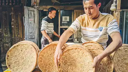
After enjoying the fun, head to your hotel in Kuqa City for rest. Kuqa, formerly known as Qiuci, is a nationally renowned historical and cultural city and a key junction on the ancient Silk Road. It was home to the ancient Qiuci, one of the "Thirty-Six Kingdoms of the Western Regions." In the evening, tourists can explore this exotic town and discover the delicious cuisine of southern Xinjiang, including barbecue, mixed noodles, pepper chicken, meatball soup, and the wheel-sized Kuqa naan.
Day 3 Kuche → Tianshan Red Stone Forest → Kizil Thousand Buddha Caves → Kuche Grand Temple → Kuche Old Street → Kuche
·morning
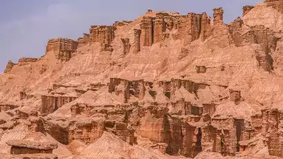
After breakfast, we'll depart for the Tianshan Red Stone Forest, a newly discovered hidden gem discovered by China-TravelNote. The Red Stone Forest is composed of reddish-brown Yardang wind-eroded landforms. Millions of years of wind and rain have eroded the rock and soil, creating a diverse array of valleys, peaks, terraces, and pillars. Within the winding gullies, large and small, layers of brown-red, yellow-green, and gray-green earthen mounds overlap, resembling a deserted ancient city.
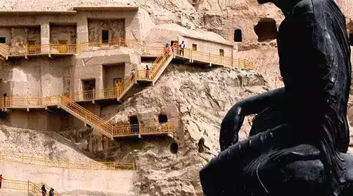
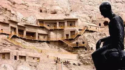
Afterwards, visit the Kizil Thousand Buddha Caves, a massive grotto complex in Xinjiang known as the "Second Mogao Grottoes." Predating the Dunhuang Mogao Grottoes by over a century, it is a key component of the Silk Road World Heritage Site. For millennia, Buddhism flourished here, with numerous monks. It was from here that Buddhism spread eastward to the Central Plains.
Kind tips:
Tickets for the Kizil Thousand Buddha Caves Scenic Area are available for pre-sale in limited quantities and time periods each day. The order of today's tours will be adjusted based on ticket availability. If tickets cannot be issued due to special circumstances, an alternative option will be to visit the Kuqa Tianshan Grand Canyon. Thank you for your understanding.
·afternoon
Proceed to Kuqa Grand Mosque, the second largest mosque in Xinjiang, second only to the Id Kah Mosque in Kashgar, with a history of 460 years.
After leaving the Great Mosque, take a walk along Restan Road in Kuqa Old Street. Restan means "shopping mall" in Uyghur. There are densely populated traditional shops here, and you can also take photos with the colorful carved wooden doors.
After having fun, return to the hotel to rest.
Day 4 Kuqa → Shaya Populus euphratica Forest → Aral City
All day
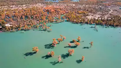
Hidden deep in the Tarim River basin, the Shaya Poplar Forest is a hidden gem for autumn viewing, often missed even by Xinjiang locals. A China-TravelNote product manager made a special trip to explore the area. The poplar trees grow along the riverbank, their golden crowns reflected on the lake surface, creating a rare "water poplar" landscape in southern Xinjiang. Compared to the more well-known Luntai Poplar Forest, the Shaya Poplar Forest offers a more pristine and tranquil atmosphere.
We had most of the day to fully experience the splendor of the Populus euphratica. China-TravelNote specially arranged a 3km light hike on the Populus euphratica (mainly on flat plank roads, easy and not tiring. If you don’t want to walk, you can take the scenic shuttle bus) to experience the Populus euphratica’s tenacious vitality up close.
After having fun, we left and went to Aral City, a corps city on the edge of the Taklamakan Desert, to check in and rest (the headquarters of the First Division of the Xinjiang Production and Construction Corps).
Day 5 Aral → Desert Highway → Sand Dunes and Poplar Trees → Wensu Grand Canyon → Aksu
·morning
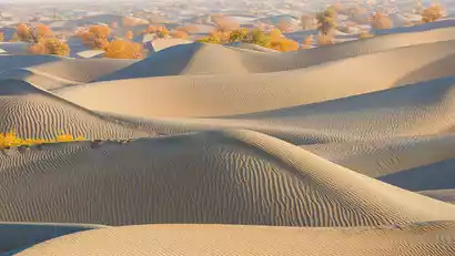
After breakfast, we will leave and cross the Tarim River into the Taklamakan Desert, known as China's largest desert. We will take a section of the [Taklamakan Desert Highway]. The Aral-Hotan Highway runs through the Taklamakan Desert from north to south, and the scenery along the way is magnificent.
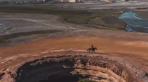
We walked and played along the way, looking for golden poplar forests among the sand dunes. The golden sand dunes and the poplars deep in the desert formed a very layered picture. You can also climb step by step along the corners of the sand dunes to the highest point and look out at the vast desert.
Kind tips:
The desert highway is 440 kilometers long and takes about 7+ hours to drive. The scenery is repetitive and the temperature is high. China-TravelNote arranges to drive a section of the desert highway (about 50 kilometers) and then turn around, not crossing the entire route.
·afternoon
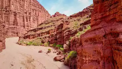
Depart for the Wensu Grand Canyon (also known as the Tomur Grand Canyon). The Wensu Grand Canyon boasts unique salt karst, Danxia, yardang, and sub-yardang landforms. It was once a crucial route on the ancient Muzhat Road, connecting the northern and southern Tianshan Mountains. Within the canyon, the rock formations are clearly defined, with folds formed by compression. Millions of years of wind and rain have eroded the canyon, creating a unique landscape of towering cliffs, towering peaks, and jagged, bizarre, and vibrant colors. We'll enter by a wild shuttle bus, journeying through the spectacular canyon, marveling at the wonders of nature and gazing down at the breathtaking city of mountains. On clear days, we'll even be able to see Tomur Peak, the highest peak in the Tianshan Mountains.
After having fun, we went to Aksu, the city of apples, to rest.
Day 6 Aksu → Kashgar (half day free at leisure)
All day
After breakfast, we'll depart for Kashgar, the heart of southern Xinjiang. We'll first apply for border passes to Tashkurgan County. After checking into our hotel, we'll have some free time. Tourists can also explore Kashgar Old Town (free of charge).
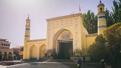
In the old city of Kashgar, you can visit the grand Id Kah Mosque (a paid scenic spot with exterior view). All roads in the old city of Kashgar lead to this mosque. For Muslims, this is not only a place of worship, but also a home for their purified souls.
The houses in the old city of Kashgar are of different heights, all of which are Islamic-style buildings made of earth, wood, brick and wood. The streets are intricate and maze-like. The century-old teahouse on the corner was the filming location of the movie "The Kite Runner"; the children playing and fighting in the alleys will be very excited to pose in various shapes for you to take pictures of them. What you see in their bright eyes is their simple hearts.
At night, you can go to Khan Bazaar Night Market (opposite the mosque) to find local specialties!

Day 7 Kashgar → Karakoram Highway → Muji Township Crater → Taheman Wetland → Tashkurgan County
·morning
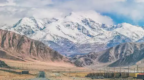
Today, we'll travel along the beautiful Karakoram Highway (China-Pakistan Friendship Highway) to the Pamir Plateau! Pamir means "Roof of the World" in Tajik. Anciently known as Buzhou Mountain and Congling, it was also where the ancient Silk Road passed through. Passing by the north shore of Baisha Lake, we'll enjoy the spectacular sight of the blue lake and sand dunes.
·afternoon
Arriving at the mysterious border village of Muji Township, we discover the unique surface volcanic cluster, the Kazhitiemi Volcanic Cluster, with 13 rare surface craters formed by eruptions 1,500 years ago. In the distance, snow-capped mountains stand in a row, known as the "Eighteen Arhats Snow Mountain Honor Guard," guarding this secret plateau.
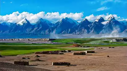
Continue to the Pamir Plateau, passing through the Taheman Wetland, and admire the wetland grasslands nurtured by the meltwater of the Muztagh Ata glacier.
In the evening, we arrived in Tashkurgan County, a small border town (around 3,000 meters above sea level, with little altitude sickness). Its predominant population is the Tajiks, a noble people of the Pamir Plateau who don't pick up lost items on the road and leave their doors unlocked at night. In the evening, you'll be free to meet up with friends and enjoy Tashkurgan's famous yak beef hotpot.
Day 8: Tianta County → Khunjerab Pass → Wakhan Corridor → Panlong Ancient Road → Visiting a Tajik Family → Tashkurgan County
·morning
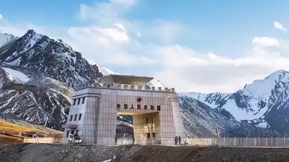
After breakfast, we will depart for a visit to Khunjerab Pass (4,700 meters above sea level). Khunjerab Pass means "blood-stained passage" in Tajik. It is the highest national gate in my country, with only 80 days of frost-free season a year. Even in summer, it is covered with snow.
·afternoon
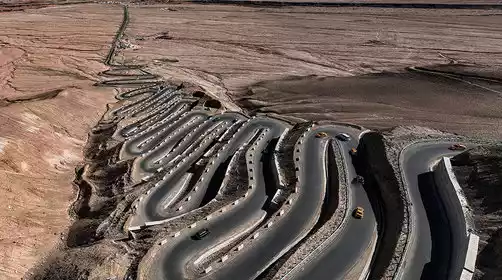
Check in at the "crossroads of the four Central Asian countries" [Wakhan Corridor], which is a narrow strip of land between China, Afghanistan, Tajikistan and Pakistan, and is also a land route connecting China and Afghanistan.
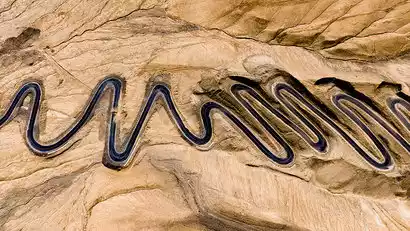
Afterwards, we changed to a small car (1 person, 1 seat) and crossed the internet-famous highway [Panlong Ancient Road], winding down with hundreds of hairpin turns in a row. "Today I have walked through all the detours in life, and from now on life will be smooth sailing."
China-TravelNote has specially arranged a [Visit to the Tajik Home], where you can visit the places where fellow villagers used to live, listen to the ethnic stories of the "Eagles of the Plateau", immerse yourself in the traditional dances of the Tajik people, and experience the charm of the nation firsthand.
Kind tips:
The Panlong Ancient Road is at a high altitude (the highest point is 4,250 meters) and has many bends. If the road is closed due to snow, you may visit the Golden Grassland Wetland and Stone City in the Pamir Scenic Area. Please understand.
Day 9: Tianta County → Shudong Highway → Karakul Lake (Muztagh Ata Peak) → Baisha Lake → Kashgar
All day
After breakfast, we'll depart for the Tree Hole Highway, our first stop! Lining the several-kilometer-long road are uniquely plateau-growing trees, their branches connected at the top. Walking through the tree holes feels like traveling back in time.
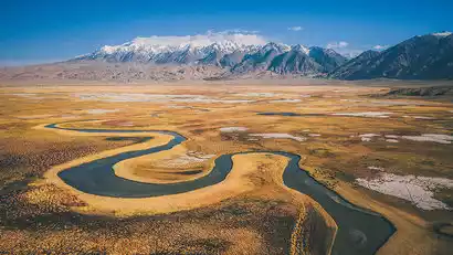
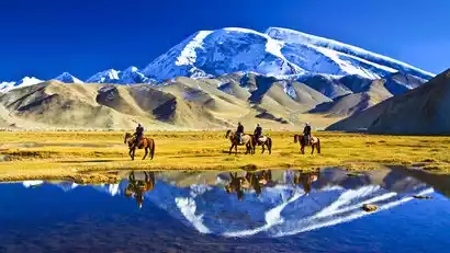
Our second stop was Karakul Lake, where we gazed upon the three majestic peaks of Kunlun: Kongur Peak (7,649 meters), Kongur Jiubie Peak (7,530 meters), and Muztagh Ata Peak (7,546 meters). The emerald blue glacial lake reflected Muztagh Ata, the "Father of Icebergs."
The third stop is to visit the Baisha Lake scenic area, where you can admire the wonders of the sand mountains and blue lakes up close.
Arrive in Kashgar in the evening and explore this bustling city in the western regions. In the evening, meet at the food street to continue shopping and eating.
Day 10 Kashgar → Warm Home (★ All Day Dismissal Day)
All day
Today is the day for the whole day to disband. Everyone left Kashgar reluctantly according to their respective travel times and returned to their warm homes.
Kashgar is the cultural center of the Western Regions. Tourists with ample time are advised to stay an extra day and explore the city freely.
Kind tips:
Check-out time for Xinjiang hotels is 14:00. The airport is about 10 kilometers from the city center (20 minutes' drive) and costs about 20-30 yuan. It is very convenient to take a taxi.