Day 1 Various locations → → Lhasa ★ Lhasa gathering day
All day
Today, tourists from all over the country will arrive in Lhasa according to their own transportation options. After checking into your hotel, you are advised to rest and acclimate to the plateau before preparing for the upcoming hike. Your tour leader will meet you at the hotel that evening to discuss the route. If you feel unwell, please contact your tour leader and guide immediately for assistance. When you first arrive on the plateau, drink plenty of water, eat a moderate amount of fruit, and rest early.
Tourists arriving by train can take a shared taxi for 20 yuan per person to the hotel; tourists arriving by plane can first take the civil aviation bus to the city center (about 1 hour), and then take a taxi for 10 yuan to the hotel.
[Tip] Tourists with ample time are advised to arrive in Lhasa a day early to rest and recuperate. On the day of arrival, avoid showering, eat plenty of vegetables and fruits, drink plenty of water, and avoid smoking and drinking. A positive mental attitude is the key to overcoming altitude sickness. Numerous studies have shown that maintaining an open-minded and optimistic attitude can alleviate the physical discomfort caused by altitude sickness.
Day 2 Lhasa → Yamdrok Lake → Karola Glacier → Manla Reservoir → Shigatse
All day
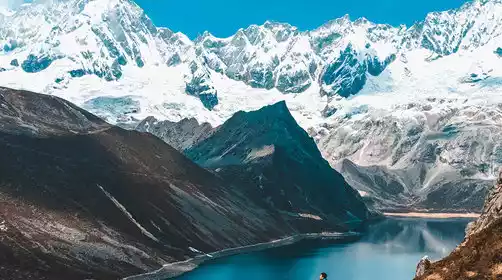
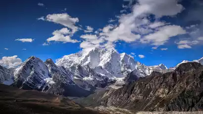
After breakfast, we'll depart and cross the Gangbala Snow Mountain Pass at an altitude of 4,990 meters to reach Yamdrok Lake, the world's highest freshwater lake and known as the Celestial Holy Lake. Known as "Jade Lake" in Tibetan, it's one of Tibet's three sacred freshwater lakes, boasting water as clear as mutton fat and sweet enough to drink. On clear days, you'll also be able to admire the Ningjin Kangsha Snow Mountain (7,206 meters) in the distance. A must-see here is to get up close and personal with the lake and pose for some crazy fun!
After lunch at Langkazi, we'll continue along the old road, passing through distinctive Tibetan villages. We'll soon reach the Karola Glacier: a sleeping ice beauty (crystal blue, majestic, misty, and breathtakingly beautiful, it's not just a geological history written by the passage of time and ice and snow, but a magnificent work of art sculpted by time). We'll cross the Manla Reservoir and reach the heroic city of Gyantse. From afar, we'll admire the Zongshan Ancient Fortress, the site of the heroic resistance against the British, allowing us to appreciate the charm of this heroic city. We'll arrive in Shigatse in the evening and check in.
Day 3 Shigatse → Jiacuo La Pass → Tingri County → Jiawu La Pass → Zhaxi Zong Township → Qudang Township
All day
After breakfast, we departed from Shigatse, passing through Lhaze and crossing the Jiacuo La Pass (also known as the Dingri Boundary) at an altitude of 5,220 meters. Countless prayer flags fluttered in the wind, and we stopped here for photos. After lunch in Dingri, we arrived at the entrance to the Mount Everest Nature Reserve. We continued along the winding mountain road, crossing the Jiawula Pass at an altitude of 5,210 meters, where we stopped for photos.
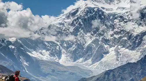
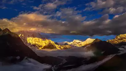
If you're lucky, you'll be able to see four snow-capped peaks over 8,000 meters: Makalu (8,463 meters), Lhotse (8,516 meters), Everest (8,844 meters), and Cho Oyu (8,201 meters). The snow-capped peaks are a panoramic view. After descending the mountain, we'll reach Tashi Dzong, the fork in the road between Everest Base Camp and Qudang Township. We'll pass through a series of stone formations left behind by tectonic shifts, and arrive in Qudang Township in the evening, dusty and windy.
Day 4: Qudang Township 3650 km → Rebu Village 3900 km → Dampu → Xiaowu Co 4650 km (Day 1 of Trekking)
All day
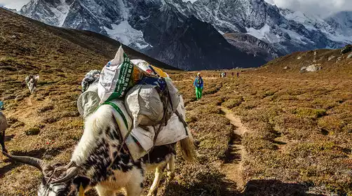
After breakfast, we'll be transported to today's hike starting point, Rebu Village. After warming up, we'll begin our hike. From Rebu, we'll ascend along a river valley to Xiaowu Co Camp, located below the Xiaowu La Pass. The hike involves three significant climbs, and the entire journey takes about six hours. Xiaowu Co is an alpine lake below the Xiaowu La Pass. On clear days, you can see Mount Makalu and Mount Everest.
Day 5: Xiaowu Co 4550 km → Xiaowu La Pass 4900 km → Zhuoxiang 3900 km (Day 2 of the trek)
All day
If you get up early and the weather is good, you'll be able to see Makalu (the world's fifth highest peak) and Mount Everest, both reflected in the sunlight, reflected in Xiaowu Lake. This is one of the best views of Makalu on this trip (and in China). When the first rays of sunlight hit Makalu's summit, I imagine it's a beauty you've never seen before.
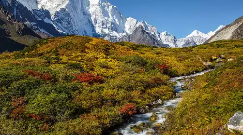
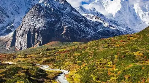
After breakfast, we'll depart at 9:30 AM to cross the Xiaowula Pass. We'll then descend through the Xueruo River Valley to reach Zhuoxiang Camp at its end. From the pass, we'll gaze upon Makalu and the lower Gama Valley. The drop from the snow-capped peaks to the Gama Valley is nearly 5,000 meters. The Xueruo Valley is lush with vegetation, and in June, large expanses of alpine rhododendrons bloom.
Day 6: Zhuoxiang 3900m → Cuolang Lake 4320m → Xianong Ranch 4450m → Tangxiang Viewing Platform 4550m (Day 3 of the Trek)
All day
After breakfast, we'll depart for the mountain trek. This climb primarily takes place within primeval forest, and the ridge at the forest's edge offers a stunning view of Gama Valley. We'll then hike through the Himalayan alpine meadows, ascending and descending, passing through [Mikai Pasture], [Colang Lake], [Tasong Pasture], and [Xianniang Pasture], then descending to our campsite at [Tangxiang].
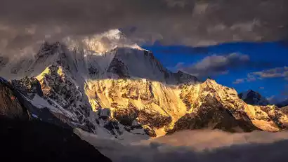
This is a rare viewing platform for our hike. When the weather is fine, you can see a series of snow-capped mountains including Mount Everest, Lhotse, Makalu, Qomolangma, Tola Gangpoche, etc. at the same time. It is one of the places to take panoramic photos of the snow-capped mountains. Another shooting point is Coxue Rinma.
Day 7: Tangxiang Viewpoint 4550m → Batang 4330m → Ega 4650m (Day 4 of Trekking)
All day
Tangxiang Camp is one of the photo spots on this trip. From here, we can simultaneously see Mount Everest, Lhotse, and Makalu's satellite peak, Qomolangzhu. Get up early to watch the sunrise over the snow-capped mountains. After breakfast, we'll depart for Ega at 9:30 AM. We'll first descend to the bottom of Gama Valley, cross the small bridge at camp, and then ascend slightly to reach Batang Camp. Further up, we'll ascend rapidly and traverse a large landslide. This area is prone to rockfall, so proceed in order and exercise caution. After crossing the landslide and passing several traverses, we'll see a large meadow and arrive at Ega, our campsite for the day.
Day 8: Ega 4650m → Baidang 4950m → Everest East Base Camp 5320m → Ega 4650m (Day 5 of the trek)
All day
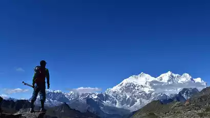
We set off early. The route from Oga to Baidang passes through two mountain ranges extending upward from Oga. The road is on the right mountain, but you can also go up the ridge on the left. It is recommended to go on the left when going up for a better view, and go down the mountain on the right when coming back. [Baidang] is a large pasture. On a clear day, the end of Baidang is the huge massif of Mount Everest and Lhotse. Across the canyon is Qomolangma, one of the best places to take photos of the snow-capped mountains.
You can choose whether to go to Dongpo Base Camp. Team members not going to Dongpo can leave later after taking photos at Oga. Team members planning to go to Everest Dongpo Base Camp should leave early after taking photos of the sunrise at Oga, arriving in about 6 hours, and then return to Baidang Camp. Today we have a closing time, and the descent back to Baidang Camp should be before 2 pm.
Day 9: Oga 4650 km → Batang 4320 km → Rega 4200 km → Cuoxuerenma 5000 km (Day 6 of the trek)
All day
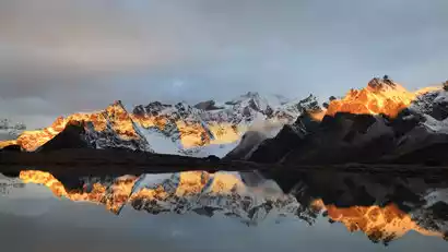
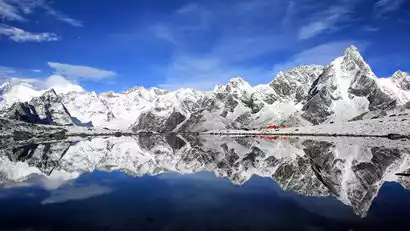
We woke up early to a feast of snowy mountains, including the remains of a vast glacier. After a series of ascents and traverses, we crossed the ridge and arrived at a valley to the right of the degraded glacier. After crossing the mountain, we could see a vast rocky beach in the center of the valley, with the Tola Gangpoche Snow Mountain directly opposite. In the evening, we arrived at our campsite, Tsokshul Rinma, a great spot for photographing the reflections of Mount Everest, Lhotse, Makalu, and Mount Qomolangma.
Day 10: Cuo Xue Ren Ma 5000 → 1 day to rest! (Day 7 of the trek)
All day
Cuoxuerenma was the highlight of the trip; the stunning scenery was well worth the effort and wait! After six days of hiking, we finally saw this visual feast. Cuoxuerenma, as a key photo spot on this trip, was well worth an extra day. It also allowed us to recover from days of high-altitude hiking and prepare for the final trek!
Day 11: Cuo Xuerenma → Langmala Pass (5400km) → Laze Camp (4550km) → Lunzhulin (4250km) → Qudang (trekking day 8) → Dinggye/Tingri
All day
Tsogol Rinma is the highlight of this trip. From here, you can not only see Mount Everest, Lhotse, Makalu, Qomolangdjo, and Tola Gangpoche, but more importantly, Tsogol Rinma acts as a mirror, allowing you to see them all reflected in it. Departing at 10:00 AM, we'll cross the Langmala Pass and return to Lunzhulin via Laze Co. We'll soon be back in civilization.
Day 12 Dingjie/Tingri → Shigatse → Lhasa (★Dismissal day)
All day
The East Slope Hike Challenge of Mount Everest is over! Today's itinerary is very relaxing, so you can sleep in a little this morning and set off in time for the return to Shigatse. On the way, let's share the hardships and enjoyments, the pain and joy of the journey, sing a farewell song, and dance happily.
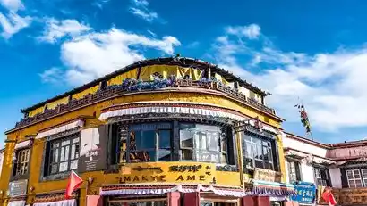
Depending on your flight or train schedule, you'll reluctantly bid farewell to the holy city of Lhasa. If you have more time, you can go to Barkhor Street and bring back some gifts for your friends and family. However, bargaining should be sincere, and it all depends on your taste. Our advice is: enjoy small purchases, but be cautious with valuables. Arrive in Lhasa around 7:00 PM
Lhasa city is about 50km from Lhasa Airport, a 50-minute drive. (Lhasa Airport, also known as Gonggar Airport, is located in Gonggar County.)