Day 1 Anywhere → or → Urumqi (★All-day gathering day)
All day
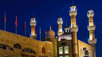
Today is the gathering day for the event. All tourists will proceed to the meeting hotel in Urumqi, the capital of Xinjiang Autonomous Region, and check in by submitting "China-TravelNote+Name".
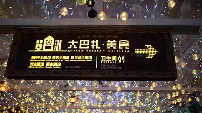
Located in the heart of Asia, Urumqi is world-renowned for its song and dance, fruits, gold, and jade. If you have more time, you can plan your own activities in downtown Urumqi. For those interested in learning about Xinjiang's culture and history, the Xinjiang Museum (free; closed on Mondays) is highly recommended. For an exotic experience, the Erdaoqiao International Grand Bazaar showcases unique Western culture and a dazzling array of goods—you might find some great finds.
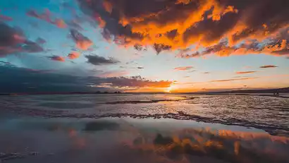
When in Urumqi, don't miss the delicious Xinjiang cuisine: the nationally renowned Dapanji (Big Plate Chicken), crispy grilled lamb chops, grilled lamb skewers, Yili horse intestines, and various specialty noodles. In autumn, sunset typically occurs at 9:00 PM, and Urumqi remains bustling even at night. Explore the Grand Bazaar Night Market for a bite to eat.
Kind tips:
1. It is recommended to prepare some dry food and snacks on your own in Urumqi on the gathering day, as there are few supply points on this trip!
2. You need to bring your own sleeping bag for this trip (comfort temperature -5°C). You can also make a note when placing an order. We provide paid rentals, but the quantity is limited.

Day 2 Urumqi → Turpan Karez → Tuyugou Mazar Village → Kumtag Desert → Shanshan
·morning
After breakfast, we'll depart for Turpan, known as the "Fire Continent," a city with one of the highest average temperatures in China. We'll visit the Jiaoheyi Karez Source, where snow from the Tianshan Mountains, dozens of kilometers away, flows through the Karez wells and becomes clear springs. This spring nourishes Turpan's Uighur people and irrigates tens of thousands of acres of vineyards, a testament to human wisdom.
Depart for Tuyugou, the sacred site of Eastern Xinjiang known as the "Little Mecca of the East." Tuyugou is a confluence of many renowned world religions and cultures. Designated a "Famous Historical and Cultural Village of China," Tuyugou Mazar Village boasts over 1,700 years of history and is one of Xinjiang's oldest remaining Uyghur villages, preserving traditional Uyghur customs. Step inside and take in the local culture and architecture.
·afternoon
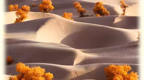
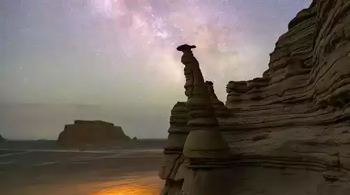
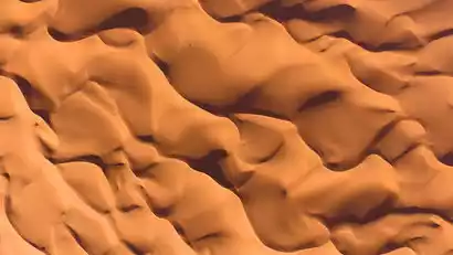
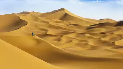
In the afternoon, we'll head to the hotel for a rest before heading to the Kumtag Desert. Located south of Shanshan County, the desert is part of the Taklamakan Desert. The golden expanse of the desert is majestic and spectacular, with sand remaining untouched and green undiminished for thousands of years.
We took the scenic shuttle bus into the desert and were specially arranged to ride a desert surfing car for a desert surfing experience. We went into the desert to shoot the spectacular sunset. The main element here is not sand dunes, but sand mountains. The curves of the desert are very beautiful. After sunset, we can explore the local specialties together in the evening.
Day 3 Shanshan → Hami Dahaidao → No Man's Land Safari → Dahaidao Core Area → Dahaidao Starry Night
·morning
After breakfast, we set off to explore the uninhabited area and officially headed towards the core area of Dahaidao.
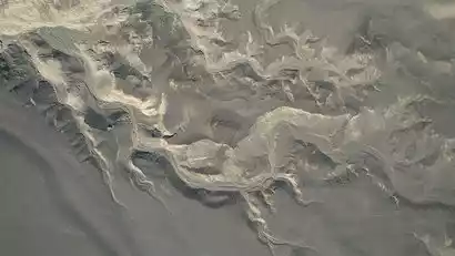
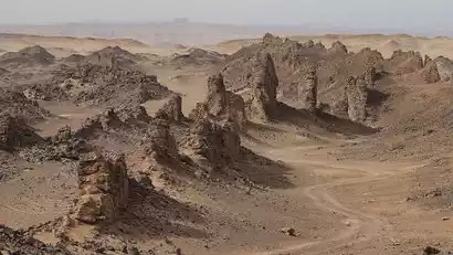
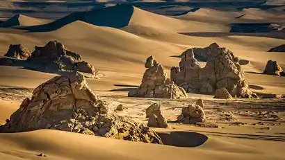
The Dahaidao, also known as the Sand Sea Road, is named after the vast sea of sand. It boasts ancient castles, beacon towers, post stations, prehistoric settlements, fossil mountains, mirages, herds of wild desert camels, and numerous other rare landforms. The Dahaidao runs southeast, stretching from Dikaner Village in Turpan, Xinjiang, in the west to Yumen Pass in Gansu, covering a distance of 456 kilometers. At its ends, it connects two important historical and cultural centers on the Silk Road: Turpan and Dunhuang.
The Hami Dahaidao, the most vibrant section of the Dahaidao, boasts the world's largest collection of yardang landforms. Today's "No Man's Land Safari" journey begins as our off-road vehicle journey continues deep into the Gobi Desert. Along the way, you can collect colorful rocks, encounter the uninhabited area's small animals, and, if you're lucky, even spot wild camels. Enjoy the scenic journey and take photos along the way.
Special Notes:
Due to the changeable climate in the no-man's land, we will flexibly arrange the itinerary in the no-man's land according to the actual situation while ensuring safety. Thank you for your understanding!
·afternoon
In the afternoon, we headed deeper into the heart of Dahaidao, taking photos as we went. We also looked for camera positions for capturing the starry sky at night. The less people go, the more rare and beautiful the scenery is.
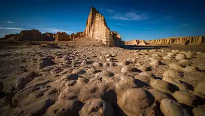
The first stop is the [Yardang Mural], a continuous mural wall over 5 meters long. The erosion of flowing water and the carving of wind and sand have created this unique water-wind erosion composite landform. It not only maintains the typical characteristics of the Yardang landform, but also exhibits rare graphic art.
The second stop is the Fairy Cave (also known as the Tongtian Cave). On the vertical section of the Yadan rock mass, the wind erosion and vortex action that has lasted for tens of millions of years has shaped layers of nested "U"-shaped etchings. A narrow crack has appeared in the cave ceiling, and sunlight is pouring down.
Leave at the right time and head to the Pterosaur Grand Canyon, where a large number of Hami pterosaur fossils have been unearthed. Wind erosion has made the cliff top undulating like a relief.
In the evening, we will look for a suitable place to set up camp and the logistics team will set up tents for everyone.
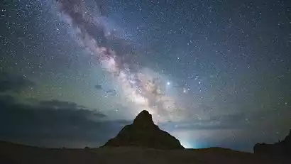
·night
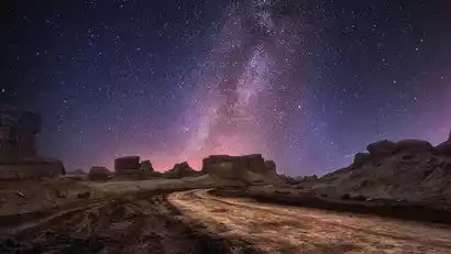
At night, under the guidance of a photography team leader, we created starry sky photography works along Dahaidao. Through astronomical observation and research, the cloudless nights, lack of light pollution, and high air transparency, combined with the ever-changing and bizarre shapes of the Yadan landforms, have made this a holy land for starry sky photography. This time, we'll let China-TravelNote starry sky photography enthusiasts capture as much as they can!
Day 4: Sunrise at Dahaidao → Safari in No Man's Land → Secret Great Wall → Eye of Lop Nur → Hotel in No Man's Land
·morning
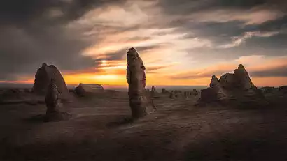
Get up early to capture the sunrise on the Dahaidao Highway, then head to one of the most famous photo spots: the "Dinosaur Eggs" on the Dahaidao Highway. The wind-eroded mushrooms in the foreground resemble dinosaur eggs, while the Yadan rock cliffs in the distance are bizarre and full of strange shapes.
Warm reminder: After photographing the sunrise, we packed up the tent and went to Hongliu Beach Restaurant for breakfast. It is recommended to bring some dry food.
·morning
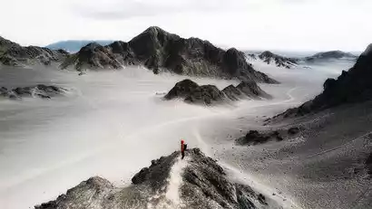
After breakfast, we started today's [No Man's Land Safari] exploration trip again. There is almost no life on the Gobi Desert. "There are no ancients in front and no future generations behind." Every step you take may be the first step of mankind. Only by going deep into it can you feel the desolation and beauty.
·afternoon
Head to the heart of Dahaidao to visit the "Great Wall of Despair" and photograph the "Eye of Lop Nur." (To capture a panoramic view of the Eye of Lop Nur, you'll need an Air-class drone or higher.) This little-known spot in the southwest of Dahaidao Scenic Area features a 2-kilometer-long, wall-like formation of yardangs, resembling the bones of a dragon. This naturally formed barrier, like a Great Wall constructed by the earth itself, derives its name from this.
·night
Tonight, we've specially arranged to stay at a newly opened hotel in the no-man's land. In the vast no-man's land, we'll wait for the sunset and enjoy a wonderful time there!
Day 5: Dahaidao → Dunhuang (free time)
All day
After breakfast, we will depart for Dunhuang, bid farewell to the mysterious Dahaidao, and have free time after check-in.
"Dun" means "big"; "huang" means "prosperous." "Dunhuang" embodies grandeur and splendor. Since ancient times, Dunhuang has served as a key Silk Road route connecting China to the Western Regions, Central Asia, and Europe, consistently serving as a thriving commercial and economic center. Today, Dunhuang stands as a center of art and culture where Eastern and Western cultures converge. It can be said to be a "Silk Pearl" nestled amidst the vast Gobi Desert.
Recommended free activities (at your own expense, pay attention to safety):
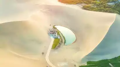
Mingsha Mountain and Crescent Moon Spring: Mingsha Mountain and Crescent Moon Spring Scenic Area, named after the sound of moving sand, is located five kilometers south of Dunhuang City. The sand and spring coexist, creating a wonderful natural beauty. It has been famous as a "desert wonder" since ancient times.
Shazhou Night Market: At night, you can go to Shazhou Night Market to pick up some local souvenirs, explore the snack shops here, order a few big skewers of meat, and then have a glass of apricot peel water. Don't mention how comfortable it is~
Day 6 Dunhuang → Heidu Mountain → Yanzhi Mountain → Lenghu Town
All day
After breakfast, we headed to Heidu Mountain for a photo tour. This is a hidden gem that has only become popular in the past two years. The continuous Yadans surround the Heidu Mountain Gobi Desert, creating a beautiful scene reminiscent of an ink painting against the vast sea of sand.
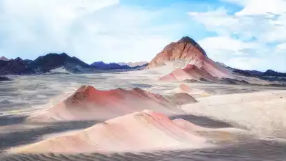
Deep within Heidu Mountain lies an even more unique site: Yanzhi Mountain. Located right next to Heidu Mountain, Yanzhi Mountain is tinged with red, resembling a touch of crimson in a natural ink painting. It's a great place to take photos, and we'll drive there to capture it.
It is suitable to leave and go to Lenghu Town for accommodation.
Day 7 Lenghu Town → Eboliang Ghost City (all day creation)
·morning
After several days of hard work, you can take a nap and have a good rest today.
Depart after breakfast and take photos of the unique desert landscape along the way.
·afternoon
Landing at the [Mars Camp], the desolate and rugged scenery around the camp makes you feel like you are on Mars.
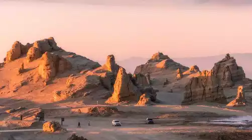
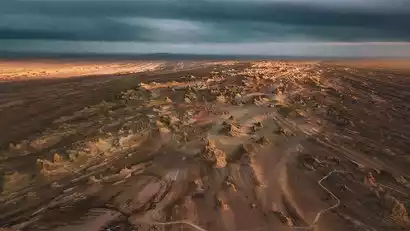
Drive to the core area of Eboliang Ghost City. If nature is likened to a skilled craftsman, the fierce northwest wind is his nimble chisel, and the clusters of hillocks before us are the unfinished work. From a distance, they resemble the surface of an alien planet; up close, their shapes vary. From a bird's-eye view, the hillocks, rigidly parallel due to wind erosion, resemble fleets sailing across the desert.
·night
In the evening, we will look for a suitable place to set up camp, and our logistics team will set up tents for everyone.
After nightfall, under the guidance and leadership of the photography team leader, we created the starry sky of Eboliang Devil City.
Day 8: Eboliang (Sunrise) → Aiken Spring → Mangya City
All day
Get up early to capture the sunrise at Eboliang Devil City. In the morning light, this desolate place, carved by time, captivates photographers with its unique charm.
Leave at the right time and head to Mangya City. If we arrive early, we will check in at the hotel and rest.
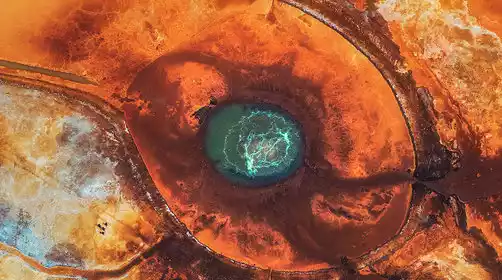
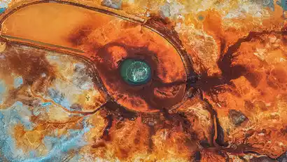
Deep within the Aral Grassland lies the Aiken Spring, a geothermal spring that has been bubbling for millennia. We'll approach the spring and, from the observation deck, gaze down upon it. Its shape resembles a medical cross-section of an eye, its veins clear and lifelike, dotted with numerous turquoise springs. From an aerial perspective, it resembles a phoenix spreading its wings in soaring flight.
Day 9 Mangya City → Mangya Emerald Lake (Sunrise) → Ruoqiang County
All day
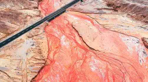
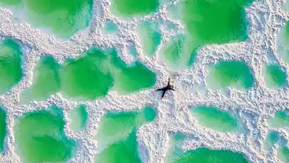
This morning, we headed to Mangya Emerald Lake for photography. After more than a decade of meticulous care by potash fertilizer workers, its color has become pure and translucent, like a piece of unpolished jade embedded in the Gobi Desert, transforming it into a new "mirror of the sky." The sun, filtering through thinner clouds, casts a myriad of colors, illuminating the lake with a dazzling array of colors.
After enjoying the photo shoot, we went to the hotel in Ruoqiang County to rest.
Special Notes:
Today's itinerary is relatively relaxed, and you can have a good rest after many days of hard work. On the way to Ruoqiang County, you will pass by the [Milan Ancient City Ruins]. If you are interested, you can visit it at your own expense.
Day 10: Ruoqiang County → Loulan Museum → Tata Secret Land (Poplars, desert, lake, stay in the scenic area)
·morning
After breakfast, we'll depart for the Loulan Museum, a museum dedicated to Loulan culture. This museum integrates the excavation, preservation, and display of cultural relics, covering sites such as the ancient city of Loulan, the Milan Ruins, and the Xiaohe Cemetery. The museum's most notable treasure, the "Loulan Beauty," boasts a 3,800-year-old artifact unearthed from the Loulan Tombs.
·afternoon
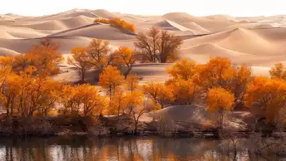
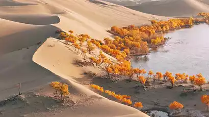
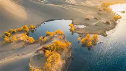
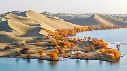
Go to [Tata Secret Land Lop Lake], which is located in a desert oasis scenic area in Yuli County, Bayingolin Mongol Autonomous Prefecture, Xinjiang. It is located on the edge of the Taklamakan Desert and at the confluence of the Tarim River and the Peacock River.
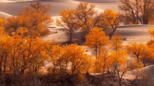
Here, you can capture the fusion of desert and lake: Robe Lake is like a sapphire inlaid in the golden desert, forming a "half sand and half water" spectacle.
You can also take photos of the combination of poplar forest, desert and lake: the clear lake water reflects the sand dunes and the sky, and together with the surrounding poplar forest, it forms a colorful natural painting.
At sunset, the lake water swallowed up the setting sun, and the entire lake turned into a "mirror of molten gold", and the leaves of the poplar trees turned into "burning golden flames". China-TravelNote specially arranged to stay in the scenic area, so there was plenty of time to take pictures.
Day 11 Tata Secret Realm → Huludao → 33rd Regiment
All day
After breakfast, depart for Huludao. Located on the edge of the Taklamakan Desert, the Tarim River bends here, creating a unique landscape of desert surrounded by emerald waters. A striking feature is the symbiosis of poplar forests, desert, and lakes. Growing between the lake and sand dunes, these trees create a remarkable spectacle of "poplars in water." This is especially true in mid-to-late October, when the leaves turn from green to yellow. Their golden shadows are reflected in the clear waters, creating a vibrant canvas against the rolling sand dunes.
Day 12 Huludao → Korla → Urumqi (Farewell Dinner)
All day
After breakfast, we will depart for Urumqi by bus and have a farewell dinner in the evening.
Estimated arrival time: 20:00. Hotel accommodation tonight is included.
Korla departure instructions:
The group is expected to arrive in Korla at 13:00. You can choose to leave Korla (the room fee for that night can be refunded if two people stay together, please note when placing the order). There are direct flights from Korla to the mainland (please book flights after 15:00).


Day 13 Urumqi (★All-day meeting day)
All day
Today is a full-day disbanding day. Tourists can sleep until they wake up naturally and bid farewell to Xinjiang reluctantly according to their own return time.