Day 1 Across the country - Kashgar (★Activity gathering day)
All day
Today is the gathering day for the event. Tourists from all over the country will check in at their hotels in Kashgar, the center of southern Xinjiang. Simply provide "China-Travel Note + Name" to check in.
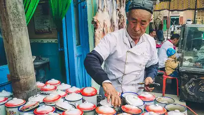
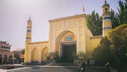
If you have more time, you can plan your own activities in Kashgar. We recommend exploring Kashgar's Old City on your own. In Kashgar's Old City, you can visit the Id Kah Mosque, China's largest mosque (not included in admission). All roads in Kashgar's Old City lead to this mosque. For Muslims, it's not just a place of worship, but a spiritual haven. Kashgar's Old City boasts a maze-like network of houses, all constructed in a uniform Islamic style of earth, wood, and brick. The streets are a maze-like experience, making it a filming location for the movie "The Kite Runner." Children playing in the alleys are eager to pose for photos, their bright eyes revealing their simple hearts. In the evening, discover local delicacies at Khan Bazaar, the Old City's night market!
Border Pass Description:
Mainland Chinese tourists: The group will go to the border control station on D8 to apply for a border pass. Each person has one pass (bring your ID card and apply in person)
Visitors from Hong Kong, Macau, and Taiwan: Please go to the Kashgar Immigration Affairs Service Center (10:00-19:00) or the local police station in your place of residence in mainland China to handle the matter.
Destination: Akto County, Kizilsu Kirgiz Autonomous Prefecture; Tashkurgan County, Kashgar Prefecture;
Traffic Tips:
Kashgar Airport is about 10 kilometers from the city center. It takes 30 minutes by taxi and costs 30-40 yuan. Taxis are plentiful and easy to get.

Day 2 Kashgar → Yarkand Khan Palace or Yarkand Khan Mausoleum → Daolang Muqam Performance → Bachu County
·morning
After breakfast, we will depart for Yarkand Khan Palace in Shache County. It is a Western Region architectural complex rebuilt on the site of the former Yarkand Palace. The exquisite brick carvings, arches, domes, symmetrical figures, regular patterns and colorful colors perfectly restore the luxury of the Islamic palace.
Important Tips
The Yarkand Khanate Palace is currently under renovation and is temporarily closed for maintenance. If it is not open in the fall, we will reroute our itinerary to visit the Yarkand Khanate Mausoleum. Thank you for your understanding!
·afternoon
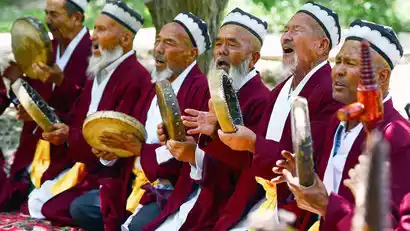
The banks of the Yarkand Khan River in southern Xinjiang are the birthplace of "Daolang Culture" and the hometown of Amanishahan, the "Mother of Uyghur Music and Dance". The people living here have not only created abundant material wealth with their hard work and wisdom, but also created a spiritual wealth that is rich in ethnic and regional characteristics and colorful - the Daolang culture represented by "Daolang Maixilaifu", "Daolang Muqam" and "Daolang Peasant Painting".
China-TravelNote specially invited the inheritors of intangible cultural heritage to perform the [Daolang Muqam Performance], which fully depicted the hunting scene and the joy of triumph.
After enjoying the photoshoot, we went to the hotel to rest.
Day 3 Bachu County → Bachu Populus euphratica Forest → Wensu Grand Canyon → Aksu
·morning
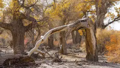
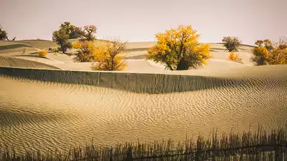
After breakfast, we set off to shoot at the Bachu Populus euphratica forest. Bachu was the seat of the Weitou Kingdom, one of the 36 kingdoms in the Western Regions, and a must-pass place in the southern border of the ancient Silk Road.
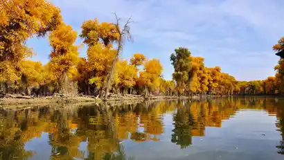
This area boasts 3.16 million mu (approximately 1.3 acres) of pristine wild poplar forest, the world's largest and oldest, earning it the nickname "Poplar Sea." Legend has it that Tang Monk and his disciples visited this area, and that the national hero Lin Zexu also stopped by. The poplar forests here are scattered along both sides of the Yarkand River. Growing naturally along the riverbanks, their golden crowns reflected in the lake, creating a rare "poplars in the water" spectacle in southern Xinjiang.
·afternoon
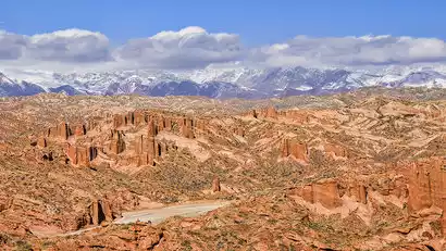
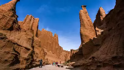
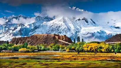
We then continued eastward along the northern edge of the Tarim Basin. In the afternoon, we arrived at the Wensu Grand Canyon for photography (featuring unique salt rock karst, Danxia, yardang, and sub-yardang landforms). This area was once a key point on the ancient Muzhat Road, connecting the northern and southern Tianshan Mountains. The canyon's walls are clearly defined, with folds formed by compression. Millions of years of wind and rain have eroded these folds, creating a unique landscape of towering cliffs, towering peaks, and jagged, bizarre, and vibrant colors. Wandering through the magnificent canyon, we marvel at the wonders of nature and gaze down upon the city of mountains. On clear days, we can even see Tomur Peak, the highest peak in the Tianshan Mountains.
Day 4 Aksu → Kuche Tianshan Grand Canyon → Baicheng Red Stone Forest → Kuche
·morning
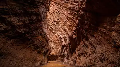
After breakfast, we'll depart for the Kuche Tianshan Grand Canyon, a short drive along the Duku Highway. The enigmatic Kuche Tianshan Grand Canyon, a canyon on the southern side of the Tianshan Mountains, is formed from reddish-brown rock through eons of wind and rain erosion. The canyon's winding paths offer a unique experience, with mountains of varying shapes and peaks soaring into the sky. Light filtering down from the canyon's summit creates a rich tapestry of light and shadow, a truly captivating spectacle for photographers. Known as the "Antelope Valley of Xinjiang," it's a breathtaking spectacle.
·afternoon
In the afternoon, we headed to China-TravelNote's newly discovered, lesser-known Red Stone Forest. Composed of reddish-brown Yardang wind-eroded landforms, the rock and soil, eroded by wind and rain over thousands of years in an arid environment, have formed a diverse array of valleys, peaks, terraces, and pillars. Within the winding gullies, large and small, layers of brown-red, yellow-green, and gray-green earthen blankets stacked one upon another resemble a deserted historic city.
After enjoying the photoshoot, we returned to the hotel to rest.

Day 5 Kuqa → Luntai Tarim Populus euphratica Forest → Luntai
All day
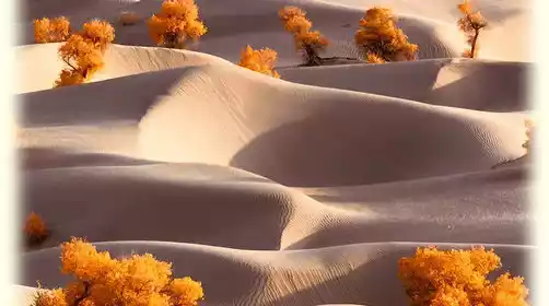
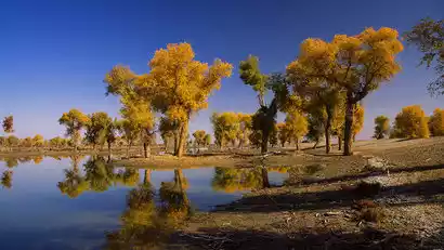
After breakfast, we'll travel east to Luntai Tarim Populus euphratica Forest Park, China's largest poplar forest park. Located in the heart of the Tarim Populus euphratica Nature Reserve, the park is known as "Toklak," meaning "beautiful tree" in Uyghur. Populus euphratica, known as "Toklak" in Uyghur, lives on both sides of the Tarim River in the northern reaches of the Taklamakan Desert, a sea of death. 90% of China's poplars are found in the Tarim River basin.
Take the shuttle bus to go deeper into the scenic area to play and take photos. According to your own shooting needs, you can choose to take the small train to go deeper (the train fee is at your own expense), or you can choose to walk and shoot along the train track. After enjoying the photos, leave the Populus euphratica forest and go to the hotel to rest.
6. Tianluntai → Shaya Populus euphratica Forest → Alar
All day
After breakfast, we will leave for Shaya Populus euphratica Forest, which is located along the Tarim River. Populus euphratica forests grow densely here. Compared with Luntai County, this area is more niche and the growth state is more primitive, so you can enjoy photography.
We left at the right time and went to Aral, the Corps city on the Tarim River, to stay and rest.
Day 7 Aral → Taklimakan Desert Highway → Hotan
All day
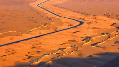
We set out early to capture the sunrise in the Taklamakan Desert. As the crimson sun slowly rose, we searched for the silhouettes of poplar trees nestled among the sand dunes, a myriad of playful light and shadow. Afterward, we journeyed south along the Desert Highway, crossing the Taklamakan Desert, a sea of death. The straight desert highway cuts through the Tarim Basin from north to south. The scenery along the way was magnificent, featuring vast expanses of golden poplar forests and clusters of sand dunes resembling a roaring dragon, their scales gleaming in the sun.
We will travel along the desert highway, photographing the surroundings, and arrive in Hotan, a major city in southern Xinjiang, in the afternoon. After check-in, we will have free time at our leisure. Hotan, formerly known as Khotan, was a key city on the southern route of the ancient Silk Road, located on the southern edge of the Tarim Basin and the northern foothills of the Karakoram Mountains. Visitors can explore Hotan's Tuancheng (Tuancheng) to photograph the local culture, or meet up at the Hotan Night Market to sample local delicacies. Afterwards, we will return to our hotel on our own.
Day 8 Hotan → Kashgar (half day free for photography)
All day
After breakfast, we will depart for Kashgar, apply for a border pass, and then check into the hotel to rest.
Today, you have half a day to take photos freely. Tourists can go to Kashgar Old Town and take photos freely according to their own preferences. After taking enough photos, they can return to the hotel to rest.
Kashgar Photoshoot Guide:
[Old Town of Kashgar]: In the Old Town of Kashgar, you can see the daily life of the Uyghur people. The houses in the Old Town of Kashgar are scattered at different heights, and the buildings are all made of earth, wood, brick and wood. The intricate streets were once the filming location of the movie "The Kite Runner". Children playing in the alleys will be very excited to pose in various shapes for you to take pictures. You can see their simple hearts from their bright eyes.
[Id Kah Mosque]: The largest mosque in the country. All roads in the old city lead to this mosque. For Muslims, this is not only a place of worship, but also a home for their purified souls.
Century-Old Teahouse: For the elderly Uyghurs living near the Id Kah Mosque, visiting the old teahouse for tea is a daily ritual. In winter, they gather around the fire, in summer, spread out on a carpet in the shade. For 1.5 yuan, they can enjoy a pot of tea, a round naan, and chat with old friends.
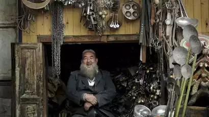
Gaotai Residences: Gaotai Residences are a Uyghur settlement in Kashgar's old city, with a history dating back 600 years. Uyghurs have lived here for generations, building their houses against the cliffs. As a family's population grows, they add a new floor to their ancestral home. This successive layering of houses and buildings has created a network of over 50 alleys that crisscross and connect in all directions, making it easy for outsiders to get lost.
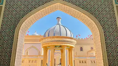
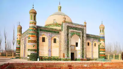
Tomb of the Fragrant Concubine: Built around 1640 AD, this 2-hectare mausoleum, a typical ancient Islamic architectural complex, serves as the burial site of a descendant of the Islamic saint. Resembling a magnificent palace, it comprises five sections: a gatehouse, a small mosque, a large mosque, a scripture hall, and the main burial chamber.
Kashgar Grand Bazaar (Under Demolition and Reconstruction): Kashgar Grand Bazaar, also known as the East Gate Grand Bazaar, stands for Central and West Asia International Trade Market. It is the largest international trade market in northwest my country. With a history spanning over 2,000 years, it was known in ancient times as "Asia's Greatest Bazaar."
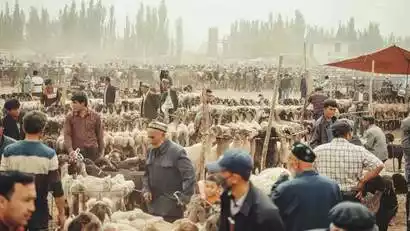
Kashgar Cattle, Sheep and Horse Bazaar: (Every Sunday during the day) This is Xinjiang's largest livestock market, and also Asia's largest cattle and livestock market. The livestock trading scene on Sundays is quite spectacular, reflecting the local customs and culture of southern Xinjiang. You will need to take a taxi to get there.
Day 9 Kashgar → Karakoram Highway → Baisha Lake North Shore → Muji Crater → Bulunkou Township
·morning
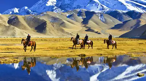
After breakfast, we'll depart along the Karakoram Highway (connecting Pakistan, also known as the China-Pakistan Friendship Highway) to photograph the Pamir Plateau, known as the "Roof of the World." "Pamir" means "Roof of the World" in Tajik, a crucial stop on the ancient Silk Road and part of the Karakoram Mountains.
·afternoon
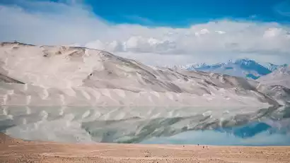
As the car continued to go deeper, we passed the north bank of Baisha Lake. Compared with the south bank with more tourists, here you can enjoy the magical landscape of blue lake and sand dunes coexisting.
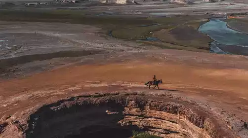
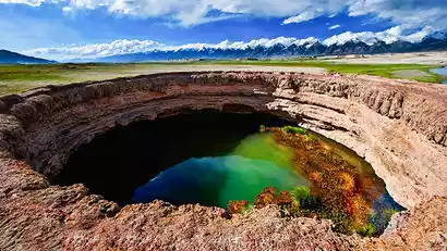
Afterward, we'll travel to the mysterious border village of Muji Township, home to the unique Kare Temir volcanic cluster, with 13 craters formed by eruptions 1,500 years ago. The Kare Temir volcanic cluster boasts classic craters, rare plateau wetlands, clear glacial lakes, and sweet glacial snowwater. Its unique geological landscapes will leave you marveling at the magical charm of nature. In the distance, the "Eighteen Arhats Snow Mountain Honor Guard" stands in formation, like guardians of the mountains, protecting this secret realm deep within the plateau.
Afterwards, we will go to the Bulenkou Township Hotel to check in and rest. As soon as we step out, we can enjoy the wonders of the coexistence of Baisha Lake and Sand Mountain. On a clear night, we can also encounter the vast starry sky of the plateau.
Day 10: Bulunkou Township → Karakul Lake (Sunrise at Muztagh Ata) → Panlong Ancient Road (Change to a car) → Taheman Wetland → Tashkurgan County
·morning
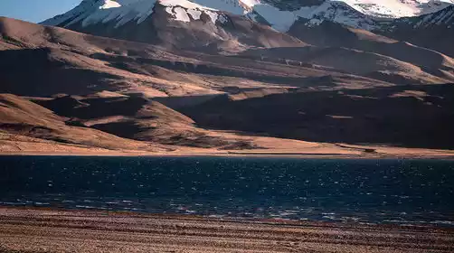
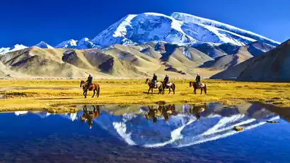
Depart early in the morning (breakfast to pack) and head to Karakul Lake to capture the sunrise over Muztagh Ata, the father of glaciers. You can also photograph the three peaks of Kunlun Mountain (7,649 meters, Kongur Peak, 7,530 meters, Kongur Jiubie Peak, and 7,509 meters) reflected in the lake.
·morning
After enjoying the photo ops, we continued deeper into the Pamir Plateau, arriving at Tashkurgan County (abbreviated as Tashkurgan County). Tashkurgan County is a famous county on my country's northwestern border (at an altitude of 3,000 meters, with virtually no altitude sickness). Its population is primarily Tajiks, a noble ethnic group living on the Pamir Plateau who don't pick up lost items on the road or lock their doors at night.
·afternoon
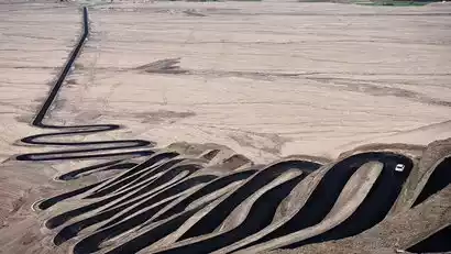
We'll traverse the Panlong Ancient Road, a popular plateau highway. With hundreds of hairpin bends and winding curves, we'll surely be astounded by the dedication of the road builders. This road, a path to poverty alleviation and prosperity, significantly shortens the distance between Waqia Township and the county seat, shortening the travel time for herders. This is of immense significance. Because the mountains along the ancient road are composed of loose sand and rock, tunnels and elevated bridges are impractical. Therefore, the road was constructed around the mountain's terrain, following the terrain in a circular S-shaped path. This resulted in the Panlong Ancient Road, with over 600 bends.
Afterwards, go to the Taheman Wetland Observation Deck to take photos of the plateau wetland scenery under the Muztagh Ata Peak, wait for the sunset, and take photos of the Muztagh Ata Peak in the golden sunlight.
After the tour, we will return to the hotel in Tashi County. In the evening, we can dine freely in Tashi County and meet up with friends to taste the local specialty yak beef hotpot.
Kind tips:
1. The Panlong Ancient Road restricts vehicles with less than 7 seats. We will change to a small car in Tashi County, with one seat per person, and stop along the way to play.
2. In October, the Panlong Ancient Road may be blocked by heavy snow. If it is impassable, the alternative route will be D11 to Muztagh Ata Glacier Park. Please understand.
Day 11: Tianta County → Sunrise at Golden Grass Beach → Tree Hole Highway → Kashgar
·morning
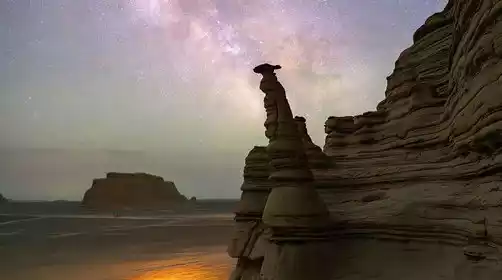
We woke up early and headed to the Pamir Scenic Area to photograph the sunrise over the Golden Grassland Wetland, with the wetland in the foreground and the Karakoram Mountains in the background. We waited for the sun to gradually illuminate the Stone City (an ancient Silk Road ruin, with broken walls and rubble inside, so the photography group didn't need to go inside).
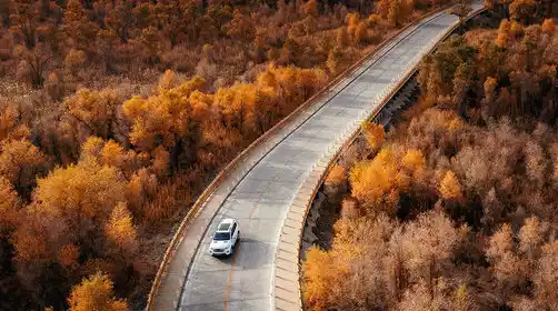
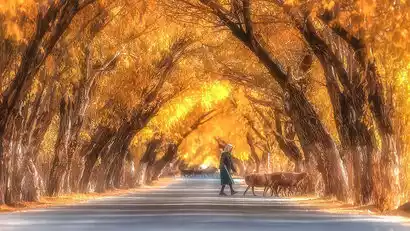
Afterwards, we headed to China-TravelNote's private, secret Tree Hole Highway. Stretching for several kilometers, the highway is lined with unique plateau-style trees, their branches connected at the top. Walking through the tree holes feels like traveling back in time.
·afternoon
Afterwards, we will return to Kashgar City Hotel along the Karakoram Highway to rest.
Day 12 Kashgar - Warm Home (★ All Day Disbandment Day)
All day
The days we spend together are always short. Today is the day for the event to end. Everyone went to Kashgar Airport or Kashgar Railway Station according to their respective travel time, reluctantly leaving southern Xinjiang and returning to their warm homes.
Kind tips:
Check-out time at Xinjiang Hotel is 14:00. The airport is about 10 kilometers away from the city center, and a taxi takes 30 minutes, costing about 30-40 yuan. There are many taxis in the city, so it is very convenient to take a taxi.