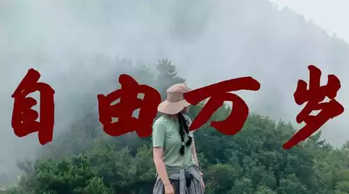
Day 1: Zhengzhou → Mawu Village → Baodu Line Sky → Baodu Village Hike to Xilian → Despair Slope → Unlit Tunnel → Xiyagou → B&B
All day
Meeting point (boarding point):
6:30 am, at the entrance of Xi'an Hotel, Zhengzhou East High-speed Railway Station (no long-term parking, please arrive early)
7:00 Zijingshan Subway Station Exit C (departs on time, please arrive early)
7:30 Liuzhuang Subway Station Exit D2 (departs on time, please arrive early)
1. Please join the WeChat travel group on the afternoon of the day before your trip (for group entry, please see the "Travel QR Code" in the app's travel notification)
2. Please arrive at the boarding point 5 minutes before the designated time. If you are late, please take a taxi to the last stop (no waiting will be made for latecomers)
10:00 Mawu Village - starting point, get ready to go
Core mission: Complete assembly and equipment inspection, and officially start hiking.
Mawu Village is located in Lingchuan, Shanxi Province, close to the cliff area at the southern foot of Taihang Mountain. Surrounded by mountains, it is the "gateway" to the core hiking area of South Taihang Mountain. Before setting off, you can quickly take a few photos of the distant mountain scenery to record the beginning of the journey.
Note: Replenish a small amount of water and energy (such as nuts, energy bars) in advance to avoid hiking on an empty stomach after departure; because the subsequent sections of the road will have many canyons and cliffs, you need to adjust your physical condition in advance and maintain good physical strength.
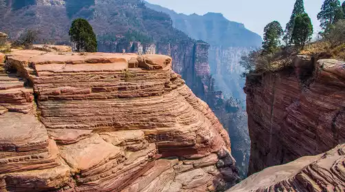
11:30 Yixiantian Grand Canyon - a midway point with both danger and beauty
Core experience: Experience the "narrow" and "dangerous" canyon crossing and appreciate the pristine natural landscape.
Yitiantian is one of the most dangerous sections of the entire route. The canyon is narrow and can only accommodate one person. One needs to use the iron chain above the rock wall to move forward slowly. When walking, pay attention to the slippery rocks under your feet (especially on rainy days) and keep a safe distance from the people in front.
You can slow down your pace and observe the natural landscape of the canyon as you go: the steep rock walls on both sides are covered with native vegetation, and sunlight shines into the canyon through the cracks, creating a mixture of light and dark, which is both "precipitous" and "beautiful". You can stop briefly at safe sections of the road to take photos.
Time arrangement: Stay here for about 15-20 minutes, take a rest and take some simple photos, then continue on your way to avoid delaying your subsequent lunch time.
13:30 Baodu Village - Rest, replenish supplies, and enjoy lunch
Upon arrival, we will go to the farmhouse that we have booked in advance to enjoy a big pot of lunch. The lunch time should be controlled within 1 hour to avoid staying too long and causing tension in the subsequent schedule.
During the meal break, you can take a quick tour of Baodu Village: there are only nine households in the village, there is no road access, and supplies are transported by iron ropes. You can experience the quiet atmosphere of this "paradise on earth".
Note: Drink plenty of water during lunch to avoid overeating; check your belongings before leaving to ensure that you have not left behind any important items (such as mobile phones, power banks, etc.).
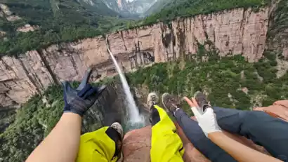
14:30 Baodu Village → Laolongkou Waterfall - Check in the iconic landscape
Core experience: Appreciate the natural wonders and take photos of the highlights of the hike.
The Laolongkou Waterfall is made up of ochre-red boulders, carved into a unique grooved landscape by the erosion of river water over hundreds of millions of years. The waterfall has a drop of over 300 meters. Standing above the waterfall, one can directly feel the steepness of the cliff and the majesty of the water flow (if it happens to be the rainy season, one can see the magnificent sight of "dragon spitting water").
Allow about 30-40 minutes for photo opportunities. You can choose to shoot from multiple angles (such as standing on the edge of a boulder to capture a panoramic view of the waterfall, or taking close-up photos of the smooth cross-section of the rock, etc.). At the same time, pay attention to safety and do not approach the dangerous area at the cliff edge. People with acrophobia should stay in flat areas.
Note: The rocks around the waterfall may be wet and slippery, so you need to walk carefully. When taking photos, keep your belongings safe to avoid dropping them while concentrating on framing the scene.
18:00 Xilian Temple - Transfer to the shuttle bus to connect to the subsequent section
Starting from Laolongkou Waterfall, it takes about 3.5 hours of hiking along the cliff edge to reach Xilian Temple. This section is the most strenuous section of the day's itinerary - walking along the edge of the cliff the entire way, passing many cliff check-in points along the way, and it is necessary to strike a balance between "viewing the scenery" and "safety", and the overall physical exertion is relatively high.
Core mission: Take the shuttle bus to quickly reach the Slope of Despair and save energy.
After arriving at Xilian Temple, there is no need to stay for long. Just go directly to the shuttle bus stop (the vehicle has been arranged in advance) and take the shuttle bus to the Slope of Despair. The journey takes about 20-30 minutes (the shuttle bus can relieve the fatigue of hiking on the cliff edge and quickly pass the flat section).
Note: Hold on to the handrail when riding the shuttle bus. Avoid walking around on the bus as the mountain road is rugged. After getting off the bus, quickly organize your equipment and prepare to enter the unlit tunnel section.
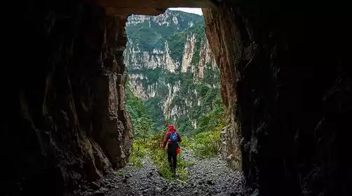
19:00 Unlit Tunnel - Adventure through the tunnel and head to the accommodation
Starting from Despair Slope, walk for about 30-40 minutes to reach the unlit tunnel. After crossing the tunnel, take a bus to Zhanggou Juyoujia. The whole journey (including tunnel crossing and bus ride) takes about 1.5 hours.
The interior of the unlit tunnel is pitch black, so you need to turn on your headlamp in advance (make sure it is fully charged). Go through it in groups of several people, and pay attention to the gravel and depressions under your feet to avoid tripping. There may be humid air currents in the tunnel, so prepare a coat in advance.
After passing through the tunnel, take a vehicle to Zhanggou near the tunnel exit. The journey takes about 20 minutes. The road along the way is mountainous. Please pay attention to safety and avoid opening the window to look out.
Note: Be careful of the slippery road when climbing the Despair Slope. If it is dark, you need to bring a headlamp. Keep the group tight when passing through the tunnel to avoid falling behind alone. Confirm the vehicle information before boarding to make sure you are going to "Zhanggou Juyoujia" to avoid riding in the wrong direction.
20:30 Zhanggou Juyoujia (farmhouse) - End of the day's itinerary, rest and relax
Core task: Complete dinner and wash up to reserve energy for the next day's trip.
After arriving at the farmhouse, place your hiking gear (such as hiking shoes and backpack) in the accommodation room and take a short break (about 10 minutes) to relieve fatigue from the whole day's hiking.
Then enjoy dinner, which consists of ten dishes and one soup. Avoid excessive drinking. Wash up as soon as possible after dinner, organize photos of the day's hike or record your thoughts and feelings. Rest before 11:00 PM to recharge your energy for the next day's trip.
Note: Before bed, please check what you'll need for the next day (especially the battery level of your power bank and drinking water). If you experience muscle soreness during the hike, simply soak your feet in hot water to relieve it.
A vehicle will be arranged to deliver your luggage to the farmhouse. If anyone is unable to complete the remaining distance the next day, they can take a bus back to Zhengzhou.

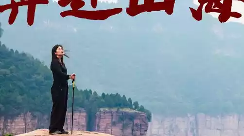
Day 2 Xiyagou B&B → Zhanggou Ladder → Shiziling → Wangmangling → Hankou → Zhengzhou
All day
The next day's itinerary focuses on the core landscape of the South Taihang Mountains, the "Double Ridge Crossing", connecting iconic nodes such as the Cross Ridge and Wangmang Ridge, combining the romance of sunrise viewing with the challenge of ridge hiking, and finally reaching the end to complete the entire journey.
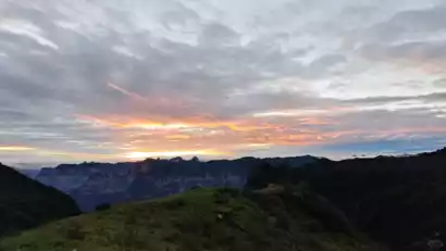
Early morning: Flexible adjustment based on weather conditions, with sunrise and hiking options available
Plan 1 (Sunrise chase preferred if the weather is fine)
04:00 Gather at the B&B and prepare for the summit: If the weather forecast indicates no rain and good visibility in the early morning, wake up at 4:00 AM, quickly wash up (it is recommended to prepare clothes, headlamps, and other equipment the night before), and after a quick breakfast (such as bread and energy bars) at the B&B, take a vehicle to the starting point of Zhanggou Ladder and begin your sunrise summit climb at Shiziling.
04:30 Depart from Zhanggou Ladder starting point and hike in the dark: With the help of headlamps, climb up the steep section of Zhanggou Ladder. This section is a high-intensity climb, so you need to concentrate and maintain a distance between the team to reach the Shiziling Viewing Platform before the dawn.
05:30-06:00 Sunrise Viewing at Shiziling: Wait for the sunrise at the highest peak in the South Taihang Mountains (1,778 meters above sea level), overlooking the rolling sea of clouds in the mountains, witnessing the sunlight penetrating the morning mist and shining on the peaks, and photographing the beautiful picture of the sunrise and the Taihang Mountain ridge.
Option 2 (Bad weather, regular departure)
06:00 Get up at the B&B, rest and prepare meals: Get up at the regular time, wash up, and enjoy a hot farm breakfast (such as millet porridge, eggs, steamed buns, etc.) at the B&B to replenish the energy needed for the whole day's hike. At the same time, check the water, dry food, sunscreen and other supplies in the backpack.
07:00 Depart from the B&B and head to the starting point of Zhanggou Ladder: Gather at the entrance of the B&B on time and take a vehicle to the starting point of Zhanggou Ladder. The drive takes about 15-20 minutes. On the way, you can briefly enjoy the morning scenery in the mountains and adjust your posture.
Morning: Cross the steep ladder and climb to the top of the highest peak in South Taihang Mountains
07:30 Starting point of Zhanggou Ladder, official hiking: Starting from Zhanggou Ladder, start climbing along the steep stairs (the railings are in disrepair, do not rely on them), use trekking poles to maintain balance, pay attention to the gravel and slippery areas under your feet, and gradually advance towards Shiziling.
09:00 Arrive at the three-way intersection and clarify the route direction: After 1.5 hours of climbing, you will reach the three-way intersection (this is the diversion point for Shiziling and Wangmangling). Follow the team leader to confirm the route to Shiziling. Stop briefly for 5-10 minutes to replenish water and relieve physical exertion.
10:00 AM Climb to the summit of Shiziling and enjoy a panoramic view of the Taihang Mountains: Continue walking along the ridgeline for another hour to reach Shiziling, the highest peak in the southern Taihang Mountains. The summit is flat, and the ridge stretches for 4-5 kilometers, offering panoramic views of the southern Taihang Mountains: south to Tianjie Mountain and Laoye Peak, west to Xiyagou and Baligou, north to Wangmangling, and east to Jiguanti and Baiyunkan. Take in the panoramic view of the "thousands of peaks towering and ravines crisscrossing" landscape. Take a photo here to commemorate your summit.
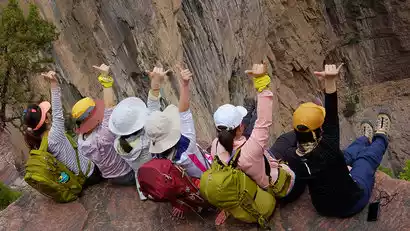
10:30 Depart from Shizilin and head towards Wangmangling: After a short rest at Shizilin, start the classic "Double Ridge Crossing Line" of South Taihang Mountains (Shizilin to Wangmangling). This section is a ridge hike at an altitude of 1500-1600 meters. Along the way, you can enjoy close views of the sea of clouds, strange peaks, pine waves, strange rocks and other landscapes. On the way, you will pass by special check-in spots such as the "囧" face, Kulong Cave, and the mountain god face. You can stop and take photos as needed.
Afternoon: Complete the Shuangling Crossing and arrive at the destination to prepare for the return journey
Resupply during the journey (flexible arrangement): You will encounter mountain supply points during the journey. You can replenish drinking water, functional drinks, instant noodles, snacks and other supplies as needed. It is recommended to limit the stop time (about 15-20 minutes) to avoid delaying the subsequent journey.
Arrive at Dishui Village at 3:00 PM and choose your descent method: After a 4.5-hour ridge hike, you'll reach Dishui Village. This is a crucial point before descending the mountain, requiring you to complete a one-hour, non-stop descent (which is challenging on the knees and balance). After descending, you can choose the following route based on your physical fitness:
Hike to Hankou (the whole journey takes about 1 hour, and the road conditions are mainly flat and descending mountain roads); (You can take a car directly to Hankou at your own expense, depending on your own situation, the drive time is about 20-30 minutes).
Arrive at Hankou at 16:00 and successfully complete the hike: No matter which method you choose, you will arrive at Hankou, the end point of this South Taihang hike, before 16:30. At this point, the "Mawu Village - Hankou" hike is successfully completed. You can take a group photo at the end to record this journey of "challenging yourself and encountering beautiful scenery."
16:30 Gather in Hankou and prepare to return to Zhengzhou: After a brief tidying up in Hankou (such as changing clothes and handling garbage), everyone gathers and takes the return vehicle to Zhengzhou, ending this South Taihang hiking trip.
Arriving in Zhengzhou city around 19:00, the bus will stop at the boarding point and kiss goodbye with tears
If you are catching a high-speed train and your trip is approaching, the bus will prioritize the fastest speed (elevated throughout the journey) and reach Zhengzhou High-speed Railway Station first to provide convenience for out-of-town tourists!
It is recommended to buy high-speed train tickets after 19:30