Bulunkou Baisha Lake
What are the most recommended things to do in Bulunkou Baisha Lake?
- Admire the turquoise lake framed by white sand hills and snow peaks.
- Photography of reflections and desert–lake contrast.
- Short walks along the lake shore.
- Enjoy sunset or sunrise views for dramatic scenery.
- Stopover on Karakoram Highway trips between Kashgar and Tashkurgan.
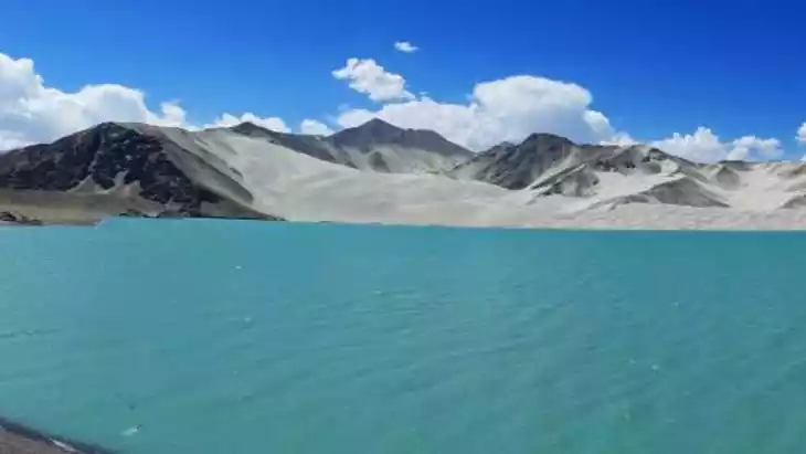
Introducing Bulunkou Baisha Lake
Bulunkou means "corner lake." It's named after the lake itself, which also has a similarly named lake to its south. Bulunkou Baisha Lake is located at the foot of a mountain on the northwest bank of the Bulunkou Reservoir in Akto County. With a maximum dam height of 35 meters and a reservoir capacity of 440 million cubic meters, its normal water level is 3,290 meters above sea level, making it a veritable "flat lake emerging from a high gorge."
The original Baisha Mountain was formed by northwest winds carrying dust from the surrounding mountains. Currently, the reservoir and Baisha Mountain are connected, and the airflow here is relatively stable, with a high probability of calm waters. The spectacular and unique combination of sand dunes, snow-capped mountains, blue sky, and white clouds often creates a striking contrast, making this an ideal photography spot.
In spring and summer, when the glacial water flow is abundant, a lake forms here. In autumn, when the flow decreases, the flat sand lake bottom emerges from the water, and thousands of streams flow along the sandy beach toward the Gaizi Gorge. Today, the Bulunkou Hydropower Station has been built here, and the lake has become flat from the high mountains. The previously visible streams and grassy wetlands along the lake are gone. However, the dam has greatly expanded the sand lake. When the water is calm, the Baisha Mountain opposite the lake is clearly reflected in the vast lake.
Climate and best time to travel
Every spring, summer, and autumn, the magical Burenkou Sand Lake offers breathtaking spectacle, with sand dancing in the wind, or a tranquil scene of mountains and water reflecting each other. The enchanting landscape and fantastic scenery of the Burenkou Sand Mountain and the lake are truly captivating.
Recommended number of days and locations for visiting
Recommended playing time: half an hour to 1 hour
Tickets
free
Attraction opening hours
All day
Most Popular FAQs for Bulunkou Baisha Lake
What is the history and significance of this attraction/city?
Bulunkou Baisha Lake, known as "White Sand Lake," formed from glacial meltwater. Its unique scenery of white sand dunes against a blue lake makes it a symbolic landscape on the Karakoram Highway.
Where is it located and how do I get there (metro, bus, taxi, walking)?
Located in Bulunkou, Kizilsu Kirgiz Autonomous Prefecture, Xinjiang, about 130 km from Kashgar along the Karakoram Highway. Accessible by car, private hire, or long-distance bus between Kashgar and Tashkurgan with a stop at the lake.
What are the opening hours and best times to visit?
Open all day, as it is a natural scenic spot. Best time: May–October, when weather is mild and lake colors are vibrant.
What is the entrance fee/ticket price, and how to buy tickets (online/offline)?
Usually free; sometimes a small fee (10–20 RMB) may be collected. Tickets, if required, are purchased on-site.
Do I need to book tickets in advance, and how far in advance?
No advance booking is necessary. Walk-in is sufficient.
How much time is needed to fully explore it?
About 1–2 hours is enough for sightseeing and photography.
What are the must-see highlights or main areas inside?
- White sand dunes surrounding the lake.
- Reflections of Muztagh Ata and snow-capped peaks.
- Color contrasts between lake, desert, and sky.
Are guided tours or audio guides available (and in which languages)?
No official guides; tours may be included in private trips from Kashgar with Mandarin- or English-speaking guides.
What are the best viewpoints or photography spots?
- Roadside viewpoint on Karakoram Highway overlooking the lake.
- Shoreline areas for sand dune reflections.
- Sunset spot on the western bank.
What is the recommended route or itinerary inside?
Stop at the roadside platform, walk down to the shore, take photos, and continue along the Karakoram Highway to Karakul Lake or Tashkurgan.
Are night visits, light shows, or special tours available?
No. It is a natural site best enjoyed in daylight.
Is it crowded, and when are the least crowded times/days to visit?
Usually quiet and uncrowded, except during summer holidays.
What facilities are available (toilets, food, water, rest areas, shops)?
Very limited facilities. Small stalls may appear in peak season, but best to bring your own water and snacks.
Is the attraction accessible for elderly, children, or disabled visitors?
Accessible from the roadside, but walking to the shore may be uneven and sandy.
Is cash needed or are cards/mobile payments accepted?
Cash is best in remote areas; mobile payments may not be reliable due to poor signal.
What restaurants or cafes are available inside or nearby?
Few or none directly at the lake. Restaurants are available along the highway or in nearby villages.
Are there vegetarian/vegan/halal food options?
Most food in the region is halal (Uyghur cuisine). Vegetarian options may be limited.
What hotels or accommodations are close to the site?
- Guesthouses in Bulunkou village.
- Hotels in Tashkurgan (south) or Kashgar (north).
What other attractions or landmarks are nearby and easy to combine in a day trip?
- Karakul Lake
- Muztagh Ata mountain
- Tashkurgan Stone Fortress
Are there souvenir shops and what are the typical souvenirs?
No official souvenir shops. In nearby towns, you can find Uyghur handicrafts, carpets, and dried fruits.
What are the best transportation options to continue the trip after visiting?
Continue south by car or bus along the Karakoram Highway to Tashkurgan, or return north to Kashgar.