New opening! 2h around Nanning, hide in the forest to unlock a healing holiday
Pingtian Mountain National Forest Park
by RevitalizeAndTravel
Feb 7, 2024
by RevitalizeAndTravel
Feb 7, 2024


Pingtianshan National Forest Park is located in Genzhu Township, Gangbei District, Guigang City, with the highest altitude of 1157.8 meters, the second highest peak in Southeast Guangxi (the first is the main peak of Darenshan in Yulin, Lianhua Peak, which is 1275.6 meters). Scattered tea gardens, hidden mountain trails in the dense fir forests, rolling alpine meadows, and if you're lucky, you might encounter the alpine sea of clouds... all are irresistibly inviting.
Location: Navigate to Pingtianshan Tea Garden (Pingtian Mountain Climbing Base), about 190 kilometers from Nanning, taking about 2.5 hours.
Tickets: Parking fee for small cars is 10 yuan, entrance ticket is 10 yuan per person (family tickets available for those with children)
Hiking distance: A round trip of 4.5-5 kilometers on the scenic area's cement stone slab road (although the route is short, it is not easy, with a continuous ascent; as observed yesterday, adults struggle to climb, while children rush up energetically)
Hiking time: About 1.5-2 hours to reach the summit, about 1 hour to descend, playtime depends on the individual
Ascent: 567 meters
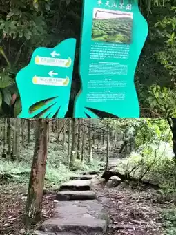
Hiking route: Tea Garden → Spring Water → Misty Rain Pavilion → Fir Forest → Mid-mountain Pavilion → Plank Path → Horse Herding Pavilion.
Check-in points: 1. Tea Garden (the scenic area has prepared two best photo spots)
2. Fir Forest on the small path of Niujiaotop (located next to the camping site) 3. Continuous alpine meadows on the mountain top, 4. Photos with cattle and horses...
Equipment suggestions: Sun hat, sun protection clothing, hiking shoes, trekking poles, quick-dry clothes, mosquito repellent, 1.5-2L of water, knee protectors (useful for descending)
Post by Ethan Cooper 890. | Jun 7, 2024