Yizhao Highway
What are the most recommended things to do in Yizhao Highway?
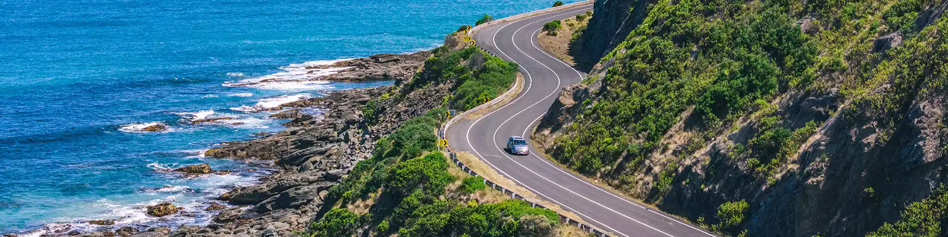
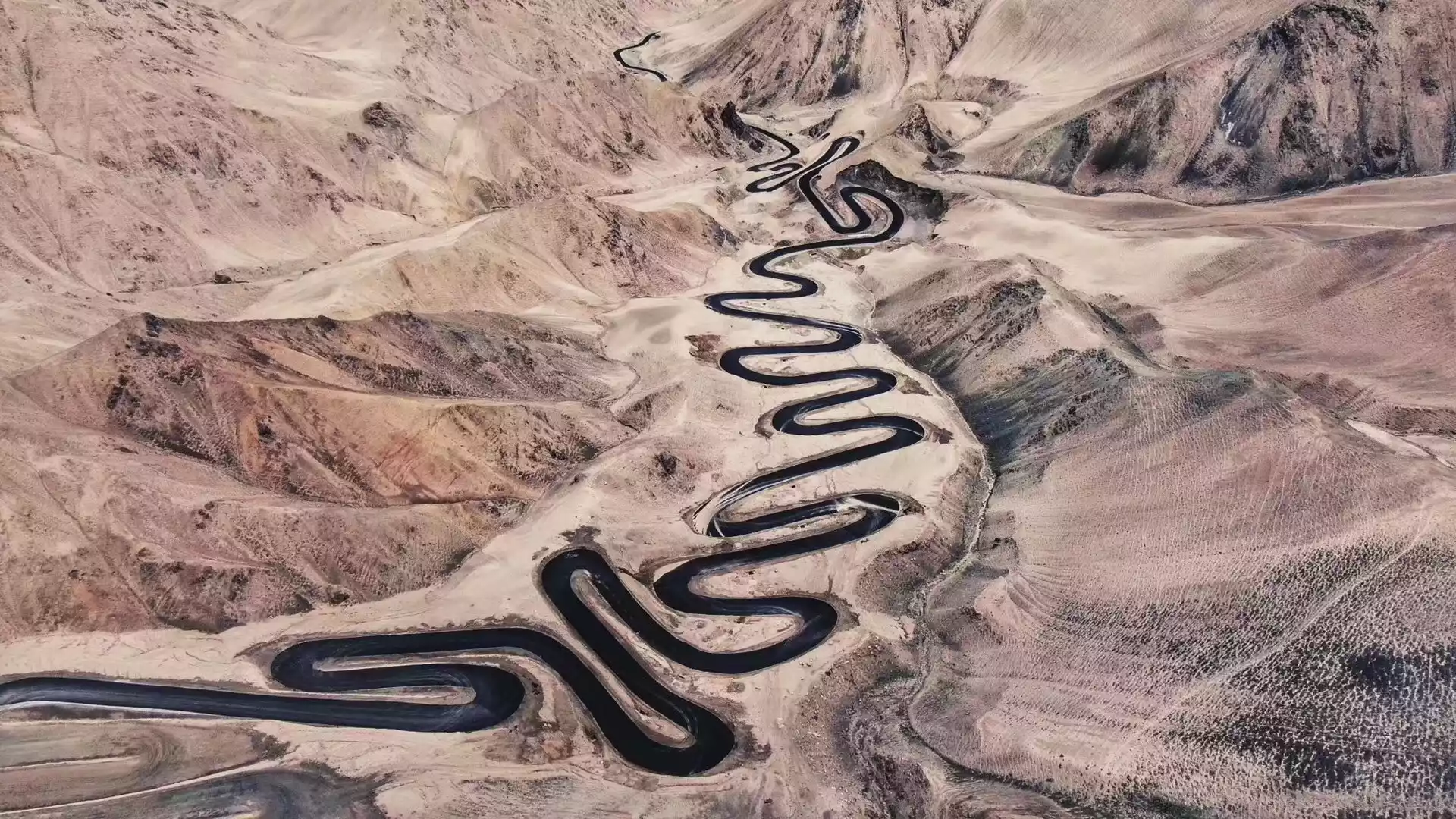
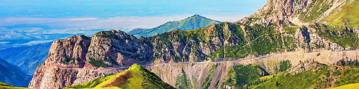
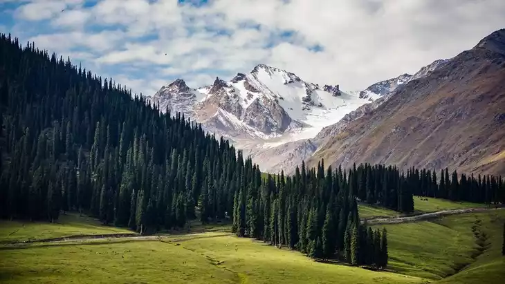
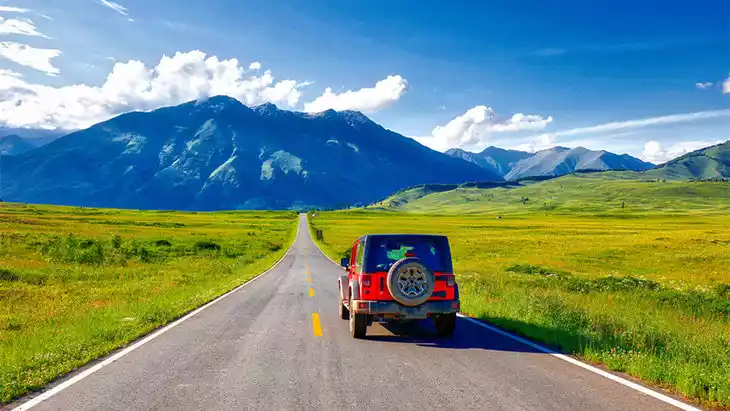
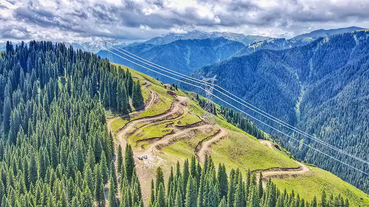
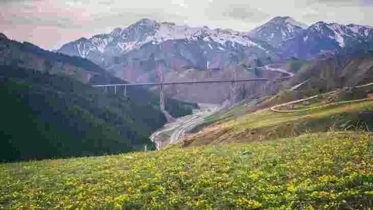
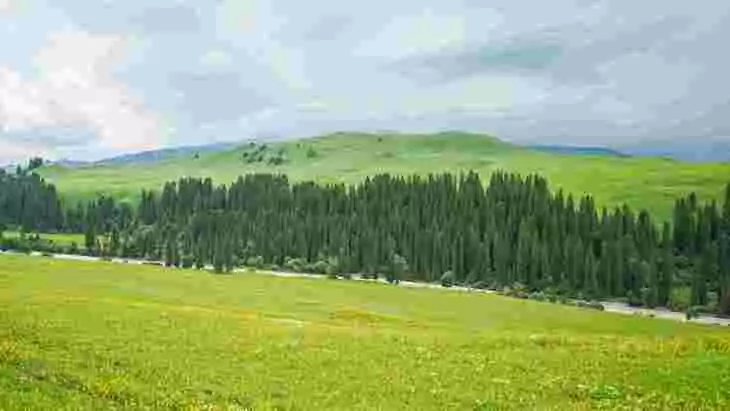
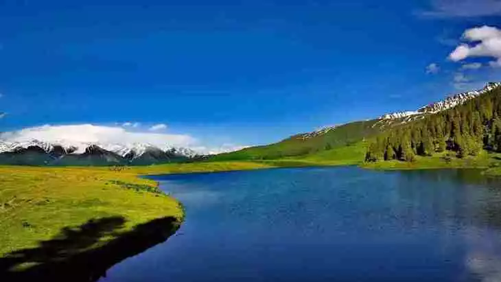
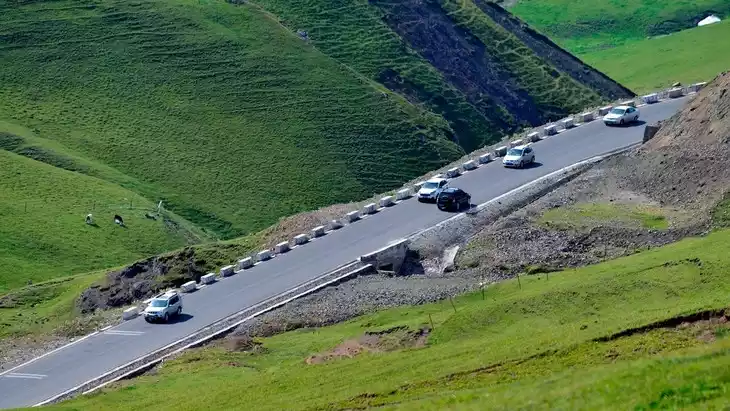
Drive or self-drive along the Yizhao Highway (S237) through the middle section of the Tianshan Mountains in the Ili Kazakh Autonomous Prefecture of Xinjiang, enjoying sweeping views of grasslands, snow-peaks, forest and river valleys. Stop at viewpoints, meadows and riversides—especially the section near the white-stone peak of Wusun Mountain and the meadow and grassland portions. Take photos of changing light and seasons—many travellers say you may see “four seasons in one day” along the route. Combine the road-trip with nearby attractions (grasslands, flower seas, ancient trails) for a full day of scenic exploration.
Introducing Yizhao Highway
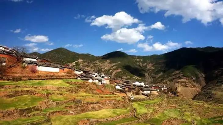
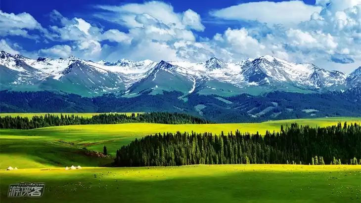
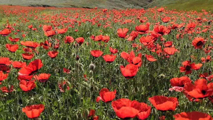
Located in Chabuchaer Sibo Autonomous County, Ili Prefecture, Xinjiang, the 180-kilometer Yizhao Highway is a veritable scenic thoroughfare, known as the "Little Duku." While not as famous as the Duku Highway, it remains one of Xinjiang's most scenic roads. Starting from the Xiate Pasture in Zhaosu County in the north and ending at the Xiate Ancient Road in Aksu Prefecture in the south, the Yizhao Highway connects the northern and southern Tianshan Mountains. The highway is closed from October each year to June, leaving it accessible for less than five months of the year. Along the way, visitors can admire a dazzling array of pine forests, Daban Passes, grasslands, alpine meadows, blooming rapeseed flowers, and herds of cattle and sheep.
Climate and best time to travel
Temperate continental climate, summer
Recommended number of days and locations for visiting
Shat Ranch, Shat Ancient Trail, one day
Tickets
free
Attraction opening hours
Open from June 1st to September 30th
Winter road closures
Most Popular FAQs for Yizhao Highway
What is the history and significance of this attraction/city?
The Yizhao Highway is an important scenic route and a segment of the old “Gongyue Road” (one of the ancient silk-road mountain paths) crossing the Tianshan. It links Yining (in Ili) to Zhaosu County, cutting through mountainous terrain and grasslands, and is often called the “Little Duku Highway” for its dramatic mountain driving. Because of its remote high-altitude route (some peaks over 3,000 m) and dramatic scenery, it has become a sought-after scenic drive in Xinjiang.
Where is it located and how do I get there (metro, bus, taxi, walking)?
Yizhao Highway is located in the Ili Kazakh Autonomous Prefecture, Xinjiang, China, running between the Yining area and Zhaosu County through the Wusun Mountain region. To access it:
- Drive or self-drive is the typical way; the scenic route is best experienced by car.
- From Yining (city) you would take a vehicle heading south towards Zhaosu via the highway route.
- Public transport options may be very limited for the full stretch; one should check local bus/van services from Yining or Zhaosu.
What are the opening hours and best times to visit?
The road is seasonally open — it generally opens in late spring/early summer and closes in late autumn due to mountain weather conditions. Travel guides say the best months are typically from June to October. As for the best time of day: start early in the morning to catch good light and avoid heavy traffic (if any) on narrow mountain stretches.
What is the entrance fee/ticket price, and how to buy tickets (online/offline)?
There is no entrance fee for driving along Yizhao Highway—it is a public highway. However, if you stop at adjacent scenic parks or grassland areas you may encounter separate fees. So check locally if you detour into specific side-attractions.
Do I need to book tickets in advance, and how far in advance?
Since Yizhao Highway itself is a road, there is no ticket to book in advance. That said:
- If you are renting a car or arranging a guided tour, it is wise to book transport ahead during peak season (summer holidays) to ensure vehicle availability.
- For nearby attractions or homestays along the route (Zhaosu, grasslands) booking ahead is recommended.
How much time is needed to fully explore it?
A drive along the key section of the Yizhao Highway typically takes 1–2 hours if just passing through and stopping briefly. However, if you plan to stop frequently for photography, grassland detours, or stay overnight in Zhaosu or stay near side attractions, allocate half a day to a full day (4–8 hours) for a richer experience.
What are the must-see highlights or main areas inside?
Highlights include:
- The winding mountain road hugging cliffs and river valleys—especially near the Wusun Mountain white-stone peak.
- Grasslands and meadows along the route where you may see herds of livestock and nomadic tents.
- Sections where forest, river, snow-peaked mountains and grasslands converge—giving the feel of “four seasons in one.”
Are guided tours or audio guides available (and in which languages)?
This is more of a scenic driving route rather than a formal attraction with built-in audio guide systems. If you book a tour (car + driver) through a travel agency in Yining or Zhaosu you may get a guide who speaks Mandarin and possibly English. But there is no standard audio-guide infrastructure documented for Yizhao Highway. Visitors should plan self-drive or private guidance accordingly.
What are the best viewpoints or photography spots?
Best photo spots:
- High mountain curves where you look down into valleys and see clouds or mist “under” you.
- Grassland meadows with snow-peaks in the background—especially in summer when green, or in autumn when poplars turn yellow.
- Riversides or meadow clearings where herds and tents might appear—this gives a “ pastoral + mountain” feel.
What is the recommended route or itinerary inside?
A recommended itinerary:
- Start from Yining city (morning), drive towards Zhaosu via Yizhao Highway. Stop at scenic loops along the way, take breaks at viewpoints and meadows.
- Mid-day lunch / brief rest in a roadside area or near a grassland village.
- Continue to the higher-altitude section (e.g., Wusun Mountain area) in the afternoon. Capture the landscape. Arrive at Zhaosu or nearby accommodation by evening.
- Optionally the next morning explore nearby attractions (grasslands, flower seas, ancient trails) before returning.
Are night visits, light shows, or special tours available?
Night visits are not the primary draw here—this is a mountain scenic road, so driving after dark may be less safe due to winding roads, fewer facilities and possibly limited lighting. There are no documented large-scale light shows along the highway. If staying overnight in Zhaosu or nearby grassland lodges, you may enjoy stargazing given low light-pollution. But plan carefully for safety and vehicle readiness.
Is it crowded, and when are the least crowded times/days to visit?
Because this route is relatively remote and seasonal, it is less crowded compared to major tourist attractions. However:
- Peak season: summer months (July-August) and autumn golden-poplar period (September) — more traffic and accommodations will fill up.
- Least crowded times: early in the season (June) or later in autumn before closure, and weekdays rather than weekend holidays. Early morning departures help avoid vehicle queues on narrow mountain stretches.
What facilities are available (toilets, food, water, rest areas, shops)?
Facilities along the highway are limited due to its remote mountainous nature. Travel tips:
- Restrooms may exist only at major stopping points or villages—not continuously along the route.
- Food & drink: very few restaurants along the road itself; bring snacks, water, sunscreen, and basic supplies.
- Gas and vehicle services: ensure fuel tank is full before entering remote stretches.
- Parking or pull-off viewpoints: there are some scenic pull-outs where you can stop safely. Reviews mention parking spots for photo stops.
Is the attraction accessible for elderly, children, or disabled visitors?
Because this is a mountain road with winding curves, altitude changes and some remote stretches, accessibility has some caveats:
- Elderly visitors: possible with car transport, but need to be comfortable with long drives, altitude and winding roads. Plan rest breaks.
- Children: fine if secured in vehicle; if you stop and walk around meadows the terrain may be uneven. Supervision advised.
- Disabled visitors: standard vehicle access is possible, but few dedicated disabled-access facilities (ramps, signage) along the road. If you have mobility challenges, plan to stay at viewpoint stops rather than hiking.
Is cash needed or are cards/mobile payments accepted?
For the highway portion itself no toll payment is specifically mentioned (aside from vehicle road tolls which may apply for the region). For any local villages, shops or homestays along the route:
- In more developed towns (Yining, Zhaosu) cards / mobile payments (e.g., WeChat Pay, Alipay) are likely accepted.
- In remote roadside villages or small stalls, cash may still be preferable. It’s wise to carry some cash (RMB) for small purchases or services.
What restaurants or cafes are available inside or nearby?
Along the main highway stretch there are very few dedicated restaurants or cafés—most dining will occur in nearby towns (Yining, Zhaosu) before or after the drive. Many travel guides warn that “there are basically no restaurants along Yizhao Highway” so plan meals in town.
Are there vegetarian/vegan/halal food options?
The region (Ili) is ethnically diverse (Kazakh, Uyghur, etc.). Halal food options are common in public eateries in towns, especially for local Muslim communities. Vegetarian/vegan options may be more limited in remote areas, so plan ahead (carry light snacks) if you follow a specific diet.
What hotels or accommodations are close to the site?
Good accommodation options are found in nearby towns such as Yining (at the start) and Zhaosu (towards the end of the route). Many visitors choose to stay overnight in Zhaosu after the drive. One travel guide recommends booking homestays or hotels ahead in Zhaosu because of limited supply in peak season.
What other attractions or landmarks are nearby and easy to combine in a day trip?
Nearby attractions you can combine include:
- Xiata Ancient Trail — ancient forest & mountain trail near Zhaosu.
- Kalajun Grassland — scenic grassland area near Zhaosu.
- Lavender Fields of Ili (in Huocheng or near Yining) — during summer a purple sea of flowers.
Are there souvenir shops and what are the typical souvenirs?
Souvenir shopping is better done in towns (Yining, Zhaosu) rather than along the highway itself. Typical souvenirs for the Ili region: dried fruits/nuts, Kazakh or Uyghur handicrafts, local wool hats, felt items, local honey or dairy-products. Bringing cash helps in smaller stalls.
What are the best transportation options to continue the trip after visiting?
After finishing the Yizhao Highway route (e.g., arriving in Zhaosu), you have options:
- Continue driving onwards into other scenic locales in Ili region (grasslands, ancient trails) or return to Yining.
- From Zhaosu or Yining you may take regional bus or arrange a car transfer back to larger hubs like Urumqi.
- If self-driving, ensure vehicle is maintained for mountainous roads; plan fuel, rest stops and return route.